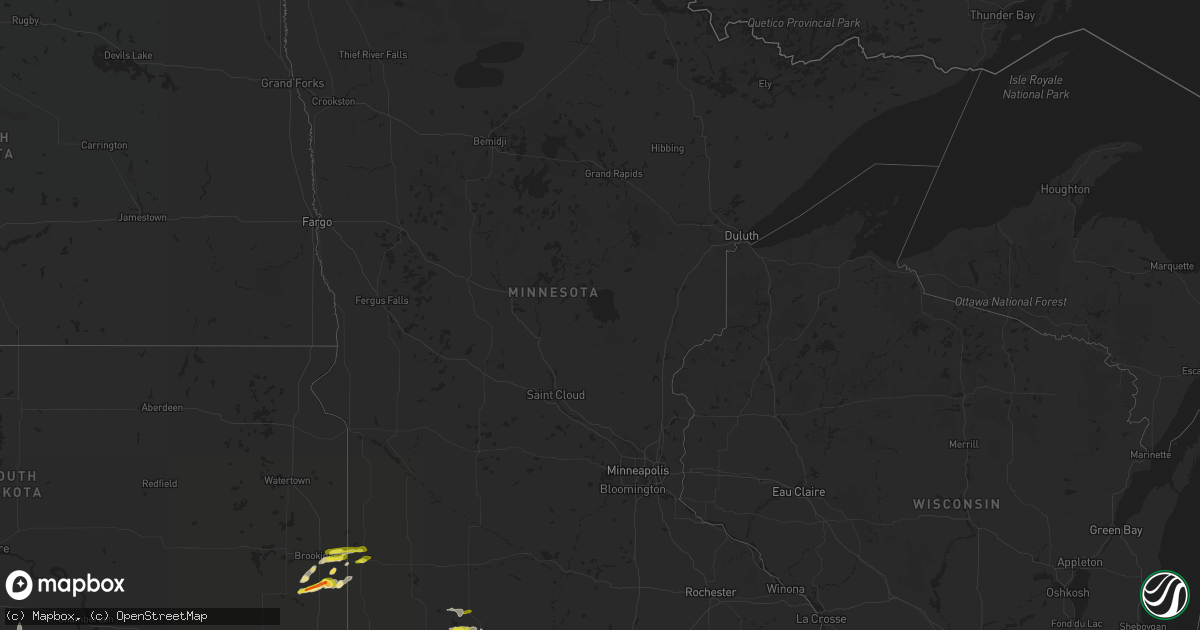
Hail Map in Minnesota on April 28, 2022
Get this storm
April 28 map
$229
one time, instant access
Download today. No call, no setup
Keep the $229
Bought the map and want the full workflow? Apply the entire $229 to a subscription within 7 days. None of it is wasted.
Every map, not just this one
This buys you this map. Subscription and you get every map we run, in the markets you choose from a few cities to whole states to nationwide. Plus real-time alerts the moment a storm fires.
Contact data
Name, contact info, occupancy, even credit band for addresses in the footprint. You go from where it hit to who to call.
Become the source they trust
Unlimited branding weather history reports on demand. You already have the documented answer ready for the property owner, and you are the one who showed up with it.
Property data and RoofTrace estimates
Pull up any address you have got, its value and the exact code rules for that jurisdiction, straight from One Click Code. Then RoofTrace estimates the squares, pitch, and roof value, priced the way you price.
Storm reports in Minnesota
Minnesota
| Date | Description |
|---|---|
| 04/28/20223:30 PM CDT | Delayed report. Public reports nickel and quarter sized hail... Did some minor damage to roof shingles. |
| 04/28/20223:00 PM CDT | A local report indicates 1.00 inch wind near 2 SSE OKABENA |
| 04/28/20222:30 PM CDT | A local report indicates 1.25 inch wind near 1 SSE WINDOM |
| 04/28/20221:42 AM CDT | At 641 PM CDT, a severe thunderstorm was located 8 miles southeast of White, or 14 miles east of Brookings, moving east at 20 mph. HAZARD...Quarter size hail. SOURCE...Radar indicated. IMPACT...Damage to vehicles is expected. This severe thunderstorm will remain over mainly rural areas of west central Lincoln and east central Brookings Counties. |
| 04/28/20221:27 AM CDT | At 626 PM CDT, a severe thunderstorm was located over Lake Benton, or 19 miles north of Pipestone, moving east at 25 mph. HAZARD...Quarter size hail. SOURCE...Radar indicated. IMPACT...Damage to vehicles is expected. This severe thunderstorm will be near... Arco around 640 PM CDT. Tyler around 645 PM CDT. |
| 04/27/202210:10 PM CDT | At 309 PM CDT, a severe thunderstorm was located near Lakefield, or 12 miles southwest of Windom, moving east at 15 mph. HAZARD...Quarter size hail. SOURCE...Radar indicated. IMPACT...Damage to vehicles is expected. Locations impacted include... Lakefield and Kilen Woods State Park. |
All States Impacted by Hail Map on April 28, 2022
Cities Impacted by Hail Map on April 28, 2022
- Albion, NE
- Wellington, KS
- Peck, KS
- Clearwater, KS
- Western, NE
- Swanton, NE
- Arapahoe, NE
- Wilsonville, NE
- Cambridge, NE
- Holbrook, NE
- Platte Center, NE
- Elgin, NE
- Clearwater, NE
- Flandreau, SD
- Elkton, SD
- Lincoln, NE
- Yankton, SD
- Mission Hill, SD
- Oxford, NE
- Milford, NE
- Seward, NE
- Pleasant Dale, NE
- Presho, SD
- Hampton, NE
- Marquette, NE
- Phillipsburg, KS
- Auburn, NE
- Prairie View, KS
- Republican City, NE
- Long Island, KS
- Agra, KS
- Naponee, NE
- Orleans, NE
- Alma, NE
- Stamford, NE
- Mount Hope, KS
- Haven, KS
- Okabena, MN
- Lakefield, MN
- Jackson, MN
- Bradshaw, NE
- Wichita, KS
- Genoa, NE
- Abilene, KS
- Oxford, KS
- Loup City, NE
- Mankato, KS
- Burr Oak, KS
- Pretty Prairie, KS
- Petersburg, NE
- Gresham, NE
- Tipton, KS
- Glen Elder, KS
- Beloit, KS
- Burrton, KS
- Buhler, KS
- Cheney, KS
- Lake Benton, MN
- Lebanon, KS
- Red Cloud, NE
- Inavale, NE
- Aurora, SD
- Brookings, SD
- White, SD
- Indianola, NE
- Monroe, NE
- Tabor, SD
- Ord, NE
- Elyria, NE
- Jewell, KS
- Randall, KS
- Luray, KS
- Saint Edward, NE
- Pierce, NE
- Wilber, NE
- Friend, NE
- Crete, NE
- Dorchester, NE
- Concordia, KS
- Wamego, KS
- Saint George, KS
- Westmoreland, KS
- Rutland, SD
- Columbus, NE
- Burden, KS
- Dexter, KS
- Winfield, KS
- Cambridge, KS
- Potter, NE
- Mayfield, KS
- Conway Springs, KS
- York, NE
- McCool Junction, NE
- Downs, KS
- Portis, KS
- Waldo, KS
- Osborne, KS
- Greeley, NE
- Spalding, NE
- Humphrey, NE
- Lindsay, NE
- Esbon, KS
- Smith Center, KS
- North Loup, NE
- Scotia, NE
- Wentworth, SD
- Colman, SD
- Pickrell, NE
- Beatrice, NE
- Sterling, NE
- De Witt, NE
- Plymouth, NE
- Adams, NE
- Tobias, NE
- Cortland, NE
- Clatonia, NE
- Saint Paul, NE
- Wolbach, NE
- Green, KS
- Clifton, KS
- Linn, KS
- Palmer, KS
- Severy, KS
- Fall River, KS
- Howard, KS
- Onaga, KS
- Alexandria, NE
- Daykin, NE
- Fairbury, NE
- Clyde, KS
- Centralia, KS
- Vermillion, KS
- Wildorado, TX
- Vega, TX
- Garden Plain, KS
- Andale, KS
- Colwich, KS
- Elwood, NE
- Hendley, NE
- Edison, NE
- Beaver City, NE
- Randolph, KS
- Barnes, KS
- Frankfort, KS
- Blue Rapids, KS
- Waterville, KS
- Hunter, KS
- Litchfield, NE
- Chapman, KS
- Wakefield, KS
- Agenda, KS
- Silver Creek, NE
- Haysville, KS
- Elba, NE
- Norfolk, NE
- Battle Creek, NE
- Bartlett, NE
- Manhattan, KS
- Glade, KS
- Henderson, NE
- Clay Center, KS
- Greenleaf, KS
- Ashton, NE
- Grenola, KS
- Rock, KS
- Cedar Vale, KS
- Atlanta, KS
- Latham, KS
- Arkansas City, KS
- Crofton, NE
- Geuda Springs, KS
- South Haven, KS
- Okeechobee, FL
- Scandia, KS
- Norway, KS
- Courtland, KS
- Formoso, KS
- Webber, KS
- Jansen, NE
- Riverton, NE
- Jamestown, KS
- Mulvane, KS
- Harper, KS
- Newman Grove, NE
- Garland, NE
- Fullerton, NE
- McCook, NE
- Osceola, NE
- Dimmitt, TX
- Hereford, TX
- Madison, NE
- Volga, SD
- Nunda, SD
- Murdock, KS
- Tryon, NE
- Kirwin, KS
- Stockton, KS
- Milton, KS
- Viola, KS
- Heron Lake, MN
- Windom, MN
- Junction City, KS
- Yates Center, KS
- Toronto, KS
- Winner, SD
- Argonia, KS
- Saint Libory, NE
- Ruthton, MN
- Pipestone, MN
- Soldier, KS
- Circleville, KS
- Piedmont, KS
- Belleville, KS
- Shelby, NE
- Ulysses, NE
- Utica, NE
- Stromsburg, NE
- Ideal, SD
- Arthur, NE
- Lemoyne, NE
- Elk Creek, NE
- Goddard, KS
- Holdrege, NE
- Havensville, KS
- Dix, NE
- Bee, NE
- Norwich, KS
- Udall, KS
- Danbury, NE
- Olsburg, KS
- Johnson, NE
- Lu Verne, IA
- Riley, KS
- Danville, KS
- Ravenna, NE
- Arco, MN
- Utica, SD
- Kensington, KS
- Cedar Rapids, NE
- Primrose, NE
- Stuart, NE
- Valley Center, KS
- Halstead, KS
- Sedgwick, KS
- Bentley, KS
- Inman, KS
- Hutchinson, KS
- Moundridge, KS
- Milford, KS
- Tyler, MN


