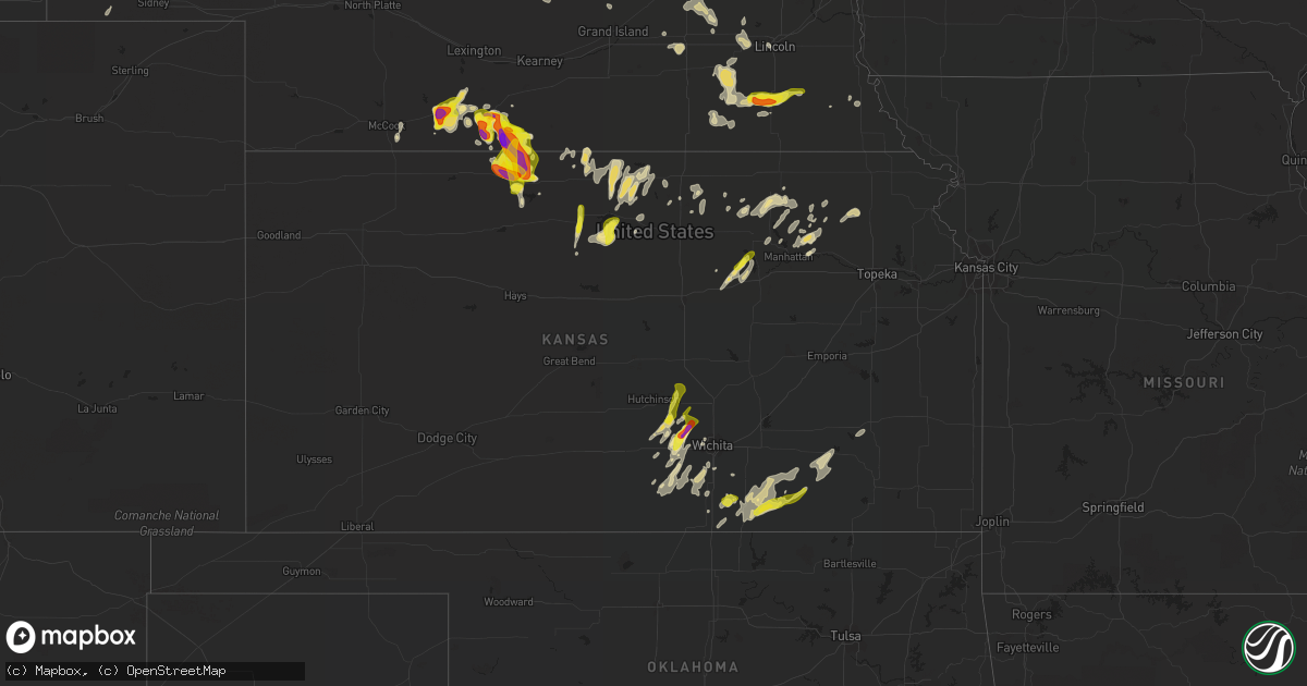
Hail Map in Kansas on April 28, 2022
Get this storm
April 28 map
$229
one time, instant access
Download today. No call, no setup
Keep the $229
Bought the map and want the full workflow? Apply the entire $229 to a subscription within 7 days. None of it is wasted.
Every map, not just this one
This buys you this map. Subscription and you get every map we run, in the markets you choose from a few cities to whole states to nationwide. Plus real-time alerts the moment a storm fires.
Contact data
Name, contact info, occupancy, even credit band for addresses in the footprint. You go from where it hit to who to call.
Become the source they trust
Unlimited branding weather history reports on demand. You already have the documented answer ready for the property owner, and you are the one who showed up with it.
Property data and RoofTrace estimates
Pull up any address you have got, its value and the exact code rules for that jurisdiction, straight from One Click Code. Then RoofTrace estimates the squares, pitch, and roof value, priced the way you price.
Storm reports in Kansas
Kansas
| Date | Description |
|---|---|
| 04/28/20226:50 PM CDT | Hail up to golf ball size lasted for about 20 minutes at highway 183 and the state line. |
| 04/28/20225:37 AM CDT | At 1035 PM CDT, severe thunderstorms were located along a line extending from 6 miles southeast of Cambridge to Stamford to near Woodruff, moving north at 10 mph. HAZARD...Half dollar size hail. SOURCE...Radar indicated. IMPACT...Damage to vehicles is expected. Locations impacted include... Cambridge, Arapahoe, Oxford, Stamford, Edison, Huntley, Hendley and Hollinger. |
| 04/28/20225:08 AM CDT | At 1007 PM CDT, a severe thunderstorm was located near Long Island, or 12 miles northwest of Phillipsburg, moving north at 10 mph. HAZARD...Half dollar size hail. SOURCE...Radar indicated. IMPACT...Damage to vehicles is expected. Locations impacted include... Primarily rural portions of northern Phillips County. |
| 04/28/20224:30 AM CDT | At 930 PM CDT, a severe thunderstorm was located near Phillipsburg, moving southeast at 15 mph. HAZARD...Golf ball size hail and 60 mph wind gusts. SOURCE...Radar indicated. IMPACT...People and animals outdoors will be injured. Expect hail damage to roofs, siding, windows, and vehicles. Expect wind damage to roofs, siding, and trees. Locations impacted include... Phillipsburg, Speed, and Glade |
| 04/28/20224:16 AM CDT | A local report indicates 1.00 inch wind near DEXTER |
| 04/28/20223:44 AM CDT | At 843 PM CDT, severe thunderstorms were located along a line extending from Agra to near Prairie View, moving south at 15 mph. HAZARD...60 mph wind gusts and half dollar size hail. SOURCE...Radar indicated. IMPACT...Hail damage to vehicles is expected. Expect wind damage to roofs, siding, and trees. Locations impacted include... Phillipsburg, Agra, Kirwin, Long Island, Prairie View, Glade and Speed. |
| 04/28/20222:59 AM CDT | At 758 PM CDT, a severe thunderstorm was located near Agra, or near Phillipsburg, moving south at 15 mph. HAZARD...Golf ball size hail and 60 mph wind gusts. SOURCE...Radar indicated. IMPACT...People and animals outdoors will be injured. Expect hail damage to roofs, siding, windows, and vehicles. Expect wind damage to roofs, siding, and trees. This severe thunderstorm will be near... Agra around 815 PM CDT.Other locations in the path of this severe thunderstorm include Gladeand Kirwin. |
| 04/28/20222:55 AM CDT | Most of the hail was pea to nickel size... But a few stones were around 2 inches in diameter. |
| 04/27/20229:45 PM CDT | Hail up to two inches in diameter reported. |
| 04/27/20229:20 PM CDT | Hail ranging from penny size to two inches in diameter reported. |
| 04/27/20229:09 PM CDT | A local report indicates 1.75 inch wind near 5 NW PHILLIPSBURG |
| 04/27/20228:40 PM CDT | Approximate time and location. |
| 04/27/20228:36 PM CDT | A few quarter size hail stones but mostly lots of smaller hail. |
| 04/27/20227:20 PM CDT | Pea to golf ball size hail. Time estimated from radar. |
All States Impacted by Hail Map on April 28, 2022
Cities Impacted by Hail Map on April 28, 2022
- Albion, NE
- Wellington, KS
- Peck, KS
- Clearwater, KS
- Western, NE
- Swanton, NE
- Arapahoe, NE
- Wilsonville, NE
- Cambridge, NE
- Holbrook, NE
- Platte Center, NE
- Elgin, NE
- Clearwater, NE
- Flandreau, SD
- Elkton, SD
- Lincoln, NE
- Yankton, SD
- Mission Hill, SD
- Oxford, NE
- Milford, NE
- Seward, NE
- Pleasant Dale, NE
- Presho, SD
- Hampton, NE
- Marquette, NE
- Phillipsburg, KS
- Auburn, NE
- Prairie View, KS
- Republican City, NE
- Long Island, KS
- Agra, KS
- Naponee, NE
- Orleans, NE
- Alma, NE
- Stamford, NE
- Mount Hope, KS
- Haven, KS
- Okabena, MN
- Lakefield, MN
- Jackson, MN
- Bradshaw, NE
- Wichita, KS
- Genoa, NE
- Abilene, KS
- Oxford, KS
- Loup City, NE
- Mankato, KS
- Burr Oak, KS
- Pretty Prairie, KS
- Petersburg, NE
- Gresham, NE
- Tipton, KS
- Glen Elder, KS
- Beloit, KS
- Burrton, KS
- Buhler, KS
- Cheney, KS
- Lake Benton, MN
- Lebanon, KS
- Red Cloud, NE
- Inavale, NE
- Aurora, SD
- Brookings, SD
- White, SD
- Indianola, NE
- Monroe, NE
- Tabor, SD
- Ord, NE
- Elyria, NE
- Jewell, KS
- Randall, KS
- Luray, KS
- Saint Edward, NE
- Pierce, NE
- Wilber, NE
- Friend, NE
- Crete, NE
- Dorchester, NE
- Concordia, KS
- Wamego, KS
- Saint George, KS
- Westmoreland, KS
- Rutland, SD
- Columbus, NE
- Burden, KS
- Dexter, KS
- Winfield, KS
- Cambridge, KS
- Potter, NE
- Mayfield, KS
- Conway Springs, KS
- York, NE
- McCool Junction, NE
- Downs, KS
- Portis, KS
- Waldo, KS
- Osborne, KS
- Greeley, NE
- Spalding, NE
- Humphrey, NE
- Lindsay, NE
- Esbon, KS
- Smith Center, KS
- North Loup, NE
- Scotia, NE
- Wentworth, SD
- Colman, SD
- Pickrell, NE
- Beatrice, NE
- Sterling, NE
- De Witt, NE
- Plymouth, NE
- Adams, NE
- Tobias, NE
- Cortland, NE
- Clatonia, NE
- Saint Paul, NE
- Wolbach, NE
- Green, KS
- Clifton, KS
- Linn, KS
- Palmer, KS
- Severy, KS
- Fall River, KS
- Howard, KS
- Onaga, KS
- Alexandria, NE
- Daykin, NE
- Fairbury, NE
- Clyde, KS
- Centralia, KS
- Vermillion, KS
- Wildorado, TX
- Vega, TX
- Garden Plain, KS
- Andale, KS
- Colwich, KS
- Elwood, NE
- Hendley, NE
- Edison, NE
- Beaver City, NE
- Randolph, KS
- Barnes, KS
- Frankfort, KS
- Blue Rapids, KS
- Waterville, KS
- Hunter, KS
- Litchfield, NE
- Chapman, KS
- Wakefield, KS
- Agenda, KS
- Silver Creek, NE
- Haysville, KS
- Elba, NE
- Norfolk, NE
- Battle Creek, NE
- Bartlett, NE
- Manhattan, KS
- Glade, KS
- Henderson, NE
- Clay Center, KS
- Greenleaf, KS
- Ashton, NE
- Grenola, KS
- Rock, KS
- Cedar Vale, KS
- Atlanta, KS
- Latham, KS
- Arkansas City, KS
- Crofton, NE
- Geuda Springs, KS
- South Haven, KS
- Okeechobee, FL
- Scandia, KS
- Norway, KS
- Courtland, KS
- Formoso, KS
- Webber, KS
- Jansen, NE
- Riverton, NE
- Jamestown, KS
- Mulvane, KS
- Harper, KS
- Newman Grove, NE
- Garland, NE
- Fullerton, NE
- McCook, NE
- Osceola, NE
- Dimmitt, TX
- Hereford, TX
- Madison, NE
- Volga, SD
- Nunda, SD
- Murdock, KS
- Tryon, NE
- Kirwin, KS
- Stockton, KS
- Milton, KS
- Viola, KS
- Heron Lake, MN
- Windom, MN
- Junction City, KS
- Yates Center, KS
- Toronto, KS
- Winner, SD
- Argonia, KS
- Saint Libory, NE
- Ruthton, MN
- Pipestone, MN
- Soldier, KS
- Circleville, KS
- Piedmont, KS
- Belleville, KS
- Shelby, NE
- Ulysses, NE
- Utica, NE
- Stromsburg, NE
- Ideal, SD
- Arthur, NE
- Lemoyne, NE
- Elk Creek, NE
- Goddard, KS
- Holdrege, NE
- Havensville, KS
- Dix, NE
- Bee, NE
- Norwich, KS
- Udall, KS
- Danbury, NE
- Olsburg, KS
- Johnson, NE
- Lu Verne, IA
- Riley, KS
- Danville, KS
- Ravenna, NE
- Arco, MN
- Utica, SD
- Kensington, KS
- Cedar Rapids, NE
- Primrose, NE
- Stuart, NE
- Valley Center, KS
- Halstead, KS
- Sedgwick, KS
- Bentley, KS
- Inman, KS
- Hutchinson, KS
- Moundridge, KS
- Milford, KS
- Tyler, MN


