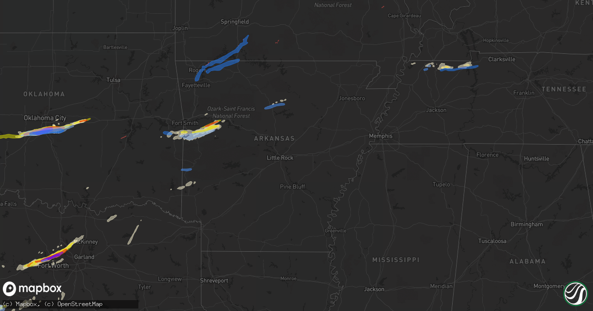
Hail Map in Arkansas on April 28, 2021
Get this storm
April 28 map
$229
one time, instant access
Download today. No call, no setup
Keep the $229
Bought the map and want the full workflow? Apply the entire $229 to a subscription within 7 days. None of it is wasted.
Every map, not just this one
This buys you this map. Subscription and you get every map we run, in the markets you choose from a few cities to whole states to nationwide. Plus real-time alerts the moment a storm fires.
Contact data
Name, contact info, occupancy, even credit band for addresses in the footprint. You go from where it hit to who to call.
Become the source they trust
Unlimited branding weather history reports on demand. You already have the documented answer ready for the property owner, and you are the one who showed up with it.
Property data and RoofTrace estimates
Pull up any address you have got, its value and the exact code rules for that jurisdiction, straight from One Click Code. Then RoofTrace estimates the squares, pitch, and roof value, priced the way you price.
Storm reports in Arkansas
Arkansas
| Date | Description |
|---|---|
| 04/28/20219:15 AM CDT | Damage to a barn. Photo posted on office facebook page. Time estimated via radar. |
| 04/28/20218:00 AM CDT | Large tree on home. |
| 04/28/20217:44 AM CDT | 1 inch tree limbs broken. Relayed via nwschat. |
| 04/28/20217:00 AM CDT | Roof damage to home. Numerous shingles removed. |
| 04/28/20215:29 AM CDT | At 1028 PM CDT, a severe thunderstorm was located near Booneville, moving northeast at 40 mph. HAZARD...60 mph wind gusts and quarter size hail. SOURCE...Radar indicated. IMPACT...Hail damage to vehicles is expected. Expect wind damage to roofs, siding, and trees. Locations impacted include... Booneville... Paris... Magazine... Subiaco... Scranton... Blue Mountain... Mount Magazine... Midway in Logan County... Tokalon... Lake Dardanelle... Havana... Barber... Dublin... Chismville... Wilkins... Corley... Grayson... Glendale in Logan County... Ione... Spring Lake Campground... |
| 04/28/20214:55 AM CDT | At 955 PM CDT, a severe thunderstorm was located 5 miles northwest of Booneville, moving northeast at 40 mph. HAZARD...Golf ball size hail and 70 mph wind gusts. SOURCE...Radar indicated. IMPACT...People and animals outdoors will be injured. Expect hail damage to roofs, siding, windows, and vehicles. Expect considerable tree damage. Wind damage is also likely to mobile homes, roofs, and outbuildings. Locations impacted include... Clarksville... Booneville... Paris... Lamar... Magazine... Knoxville... Subiaco... Hartman... Scranton... Ratcliff... Hinkle... Hoyt... Mount Magazine... Midway in Logan County... Spadra... Tokalon... Lake Dardanelle... Coal Hill... Caulksville... Morrison Bluff...This includes Interstate 40 between mile markers 54 and 63. |
| 04/28/20214:27 AM CDT | At 927 PM CDT, a severe thunderstorm was located over Excelsior, moving east at 40 mph. HAZARD...70 mph wind gusts. SOURCE...Radar indicated. IMPACT...Expect considerable tree damage. Damage is likely to mobile homes, roofs, and outbuildings. Locations in or near the path include... Fort Smith... Charleston... Greenwood... Barling... Lavaca... Hackett... Huntington... Branch... Midland... Excelsior... Bloomer... Washburn... Burnville... Fort Chaffee... Jenny Lind... Central City... Arkola... Crossroads... Witcherville... Dayton...This includes Interstate 540 between mile markers 12 and 13. |
| 04/28/20214:17 AM CDT | At 917 PM CDT, a severe thunderstorm was located over Midland, or 17 miles east of Poteau, moving east at 50 mph. HAZARD...Golf ball size hail and 70 mph wind gusts. SOURCE...Radar indicated. IMPACT...People and animals outdoors will be injured. Expect hail damage to roofs, siding, windows, and vehicles. Expect considerable tree damage. Wind damage is also likely to mobile homes, roofs, and outbuildings. Locations impacted include... Booneville... Paris... Mansfield... Magazine... Ratcliff... Blue Mountain... Echo... Caulksville... Barber... Roseville... Lucas... Chismville... Liberty... Carbon City... Sugar Grove... Driggs... Carolan... Grayson... Glendale in Logan County... Ione... |
| 04/28/20214:06 AM CDT | At 906 PM CDT, a severe thunderstorm was located 3 miles northwest of Cameron, moving northeast at 30 mph. HAZARD...70 mph wind gusts and quarter size hail. SOURCE...Radar indicated. IMPACT...Hail damage to vehicles is expected. Expect considerable tree damage. Wind damage is also likely to mobile homes, roofs, and outbuildings. Locations in or near the path include... Fort Smith... Van Buren... Poteau... Greenwood... Barling... Pocola... Spiro... Arkoma... Panama... Hackett... Huntington... Bonanza... Midland... Cameron... Moffett... Excelsior... Fort Smith Regional Airport... Jenny Lind... Burnville... Shady Point...This includes the following highways, Interstate 40 in Arkansas between mile markers 4 and 6. Interstate 540 between mile markers 1 and 14. |
| 04/28/20212:34 AM CDT | At 734 PM CDT, a severe thunderstorm was located 4 miles northeast of Ratcliff, moving east at 60 mph. HAZARD...60 mph wind gusts and quarter size hail. SOURCE...Radar indicated. IMPACT...Hail damage to vehicles is expected. Expect wind damage to roofs, siding, and trees. Locations in or near the path include... Altus... Denning... Wiederkehr Village... Etna... Peter Pender... Alix... Meg... |
| 04/27/20219:38 PM CDT | Trees down on highway 252. |
| 04/27/20219:33 PM CDT | Reported on highway 10. |
| 04/27/20219:25 PM CDT | Fire department reports pea to quarter size hail. |
| 04/27/20217:42 PM CDT | Golf ball size hail reported in denning. |
Cities Impacted by Hail Map on April 28, 2021
- Brownwood, TX
- Lohn, TX
- Rochelle, TX
- Rockwood, TX
- Santa Anna, TX
- Brookesmith, TX
- Gouldbusk, TX
- Doole, TX
- Uvalde, TX
- Leakey, TX
- Utopia, TX
- Vanderpool, TX
- Barksdale, TX
- Hunt, TX
- Rocksprings, TX
- Mountain Home, TX
- Camp Wood, TX
- Gustine, TX
- Garden City, TX
- Haslet, TX
- Azle, TX
- Southlake, TX
- Keller, TX
- Fort Worth, TX
- Roanoke, TX
- Novice, TX
- San Angelo, TX
- Newcastle, OK
- Blanchard, OK
- Colorado City, TX
- Westbrook, TX
- Coahoma, TX
- San Antonio, TX
- Wingate, TX
- Robert Lee, TX
- Bronte, TX
- Brackettville, TX
- Ovalo, TX
- Baird, TX
- Coleman, TX
- Goldsboro, TX
- Winters, TX
- Cross Plains, TX
- Clyde, TX
- Amber, OK
- Norman, OK
- Tuttle, OK
- Newalla, OK
- Pocasset, OK
- Eden, TX
- Millersview, TX
- Concan, TX
- Medina, TX
- Rio Frio, TX
- Eola, TX
- Devine, TX
- Hondo, TX
- Castroville, TX
- D Hanis, TX
- Sabinal, TX
- Rio Medina, TX
- Melvin, TX
- Blanket, TX
- Comanche, TX
- Sidney, TX
- Dublin, TX
- Rising Star, TX
- May, TX
- Early, TX
- Bangs, TX
- Aspermont, TX
- Old Glory, TX
- Paint Rock, TX
- Knippa, TX
- Justin, TX
- Menard, TX
- Coal Hill, AR
- Altus, AR
- Ozark, AR
- Magazine, AR
- Paris, AR
- Branch, AR
- Ratcliff, AR
- Comstock, TX
- Del Rio, TX
- Rule, TX
- Weinert, TX
- Throckmorton, TX
- Haskell, TX
- Rochester, TX
- Hurst, TX
- North Richland Hills, TX
- Bedford, TX
- Euless, TX
- Haltom City, TX
- Colleyville, TX
- Hico, TX
- Rotan, TX
- Atascosa, TX
- Lytle, TX
- Natalia, TX
- La Coste, TX
- Quemado, TX
- Laughlin Afb, TX
- La Pryor, TX
- Batesville, TX
- Eagle Pass, TX
- Bulverde, TX
- Kerrville, TX
- Jbsa Lackland, TX
- Tarpley, TX
- Comfort, TX
- Mico, TX
- Von Ormy, TX
- Cibolo, TX
- Center Point, TX
- Yancey, TX
- Bandera, TX
- New Braunfels, TX
- Poteet, TX
- Schertz, TX
- Somerset, TX
- Kyle, TX
- Canyon Lake, TX
- Pearsall, TX
- San Marcos, TX
- Moore, TX
- Gracemont, OK
- Prague, OK
- Anadarko, OK
- Chickasha, OK
- Shawnee, OK
- Verden, OK
- Tecumseh, OK
- Mcloud, OK
- Oklahoma City, OK
- Earlsboro, OK
- Seminole, OK
- Paden, OK
- Stanton, TX
- Clinton, AR
- Prosper, TX
- Frisco, TX
- Flower Mound, TX
- Grapevine, TX
- Lewisville, TX
- Lake Dallas, TX
- Millsap, TX
- The Colony, TX
- Little Elm, TX
- Mckinney, TX
- Weatherford, TX
- Itasca, TX
- Clarksville, AR
- Hartman, AR
- Talpa, TX
- Union City, TN
- South Fulton, TN
- Spur, TX
- Snyder, TX
- Vancourt, TX
- Christoval, TX
- Eldorado, TX
- Martin, TN
- Mccurtain, OK
- Nocona, TX
- Saint Jo, TX
- Cameron, OK
- Pocola, OK
- Windom, TX
- Dodd City, TX
- Bonham, TX
- Honey Grove, TX
- Dresden, TN
- Fort Smith, AR
- Charleston, AR
- Subiaco, AR
- Huntington, AR
- Booneville, AR
- Greenwood, AR
- Big Spring, TX
- Sulphur Springs, TX
- Kopperl, TX
- Palmersville, TN
- Paris, TN
- Cottage Grove, TN
- Olney, TX
- Newcastle, TX
- Fluvanna, TX
- Dover, TN
- Puryear, TN
- Buchanan, TN
- Springville, TN
- Big Sandy, TN
- Mullin, TX
- Pottsville, TX
- Mountain View, AR
- Ozona, TX
- Jayton, TX
- Strawn, TX
- Gordon, TX
- Boyd, TX
- Hackett, AR
- Walnut Springs, TX
- Iredell, TX
- Springtown, TX
- Umpire, AR
- Dierks, AR
- Lampasas, TX
- Burnet, TX
- Grannis, AR
- Dickens, TX
- Lawn, TX
- Scranton, AR
- Breckenridge, TX
- Glen Rose, TX
- Grandview, TX
- Eagletown, OK
- Gillham, AR
- Bokoshe, OK
- Carlton, TX
- Poteau, OK
- Spiro, OK
- Hartford, AR
- Mansfield, AR
- Shady Point, OK
- Midland, AR
- Broken Bow, OK
- Pattonville, TX
- Mineral Wells, TX
- Aledo, TX
- Santo, TX
- Celina, TX
- Burkett, TX
- Choctaw, OK
- Argyle, TX
- Paris, TX
- Cooper, TX
- Lake Creek, TX
- Bowie, TX
- Montague, TX
- Justiceburg, TX
- Milburn, OK
- Tishomingo, OK
- Norton, TX
- Fox, AR
- Shirley, AR
- Wickes, AR
- Ralls, TX
- Crosbyton, TX
- Fort Cobb, OK
- Carnegie, OK
- Okemah, OK
- Boley, OK
- Loraine, TX
- Ingram, TX
- Rives, TN
- Stewart, TN
- Keota, OK
- Indianola, OK
- Mcalester, OK
- Lake Ariel, PA
- Dalton, PA
- Factoryville, PA
- Moscow, PA
- Clarks Summit, PA
- Scranton, PA
- Olyphant, PA
- Jessup, PA
- Caddo, TX
- Zephyr, TX
- Crystal City, TX
- Chadwick, MO
- Rockaway Beach, MO
- Eagle Rock, MO
- Shell Knob, MO
- Reeds Spring, MO
- Springdale, AR
- Branson, MO
- Garfield, AR
- Lampe, MO
- Blue Eye, MO
- Rogers, AR
- Fayetteville, AR
- Golden, MO
- Berryville, AR
- Eureka Springs, AR
- Garrison, MO
- Walnut Shade, MO
- Kimberling City, MO
- Forsyth, MO
- Taneyville, MO
- Lowell, AR
- Green Forest, AR
- Omaha, AR
- Oak Grove, AR
- Hollister, MO
- Ridgedale, MO
- Drury, MO
- Edgemont, AR
- Smithville, OK
- Mena, AR
- Hatfield, AR
- Marble Hill, MO


