Hail Map in Great Bend, KS on April 28, 2019
The weather event in Great Bend, KS on April 28, 2019 includes Hail map. 6 states and 244 cities were impacted and suffered possible damage. The total estimated number of properties impacted is 3,082.
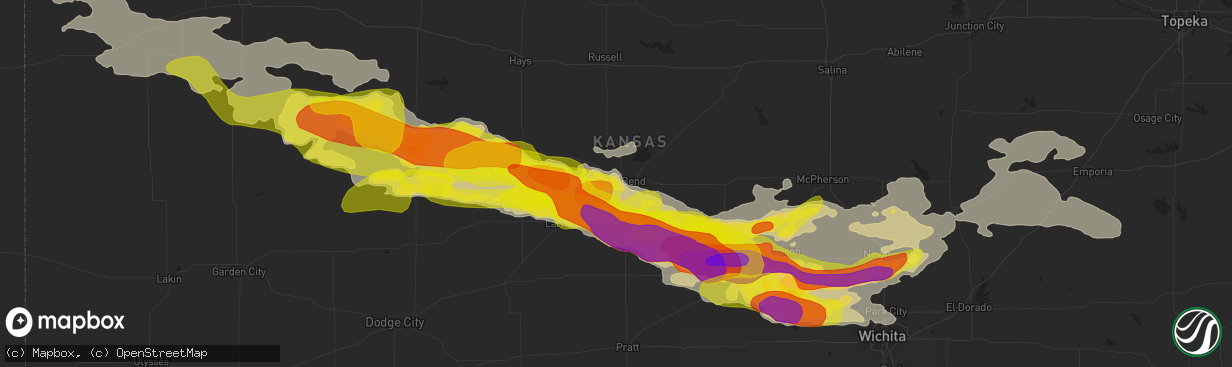
Hail
3,082
Estimated number of impacted properties by a 1.00" hail or larger53
Estimated number of impacted properties by a 1.75" hail or larger0
Estimated number of impacted properties by a 2.50" hail or largerStorm reports in Great Bend, KS
Great Bend, KS
| Date | Description |
|---|---|
| 04/27/201911:05 PM CDT | At se 50 road and se 60 ave. |
| 04/27/201910:56 PM CDT | A local report indicates 74 MPH wind near GREAT BEND AIRPORT |
| 04/27/201910:55 PM CDT | A local report indicates 67 MPH wind near GREAT BEND AIRPORT |
| 04/27/201910:55 PM CDT | West side of town. |
| 04/27/201910:50 PM CDT | At west 56 highway and sw 40 ave. |
All Cities Impacted by Hail Map on April 28, 2019
- Ness City, KS
- Park, KS
- Gove, KS
- Quinter, KS
- Rush Center, KS
- Topeka, KS
- Maple Hill, KS
- Whitewater, KS
- Newton, KS
- Halstead, KS
- Hillsboro, KS
- Bushton, KS
- Scott City, KS
- Healy, KS
- Roxbury, KS
- Canton, KS
- Galva, KS
- Gypsum, KS
- Cedar Point, KS
- Elmdale, KS
- Cottonwood Falls, KS
- Norborne, MO
- Burrton, KS
- Sedgwick, KS
- Hutchinson, KS
- Bazine, KS
- La Crosse, KS
- Alexander, KS
- Cheney, KS
- Sterling, KS
- Stafford, KS
- Dighton, KS
- Ellinwood, KS
- Brownell, KS
- McCracken, KS
- Rozel, KS
- Alden, KS
- Nickerson, KS
- Great Bend, KS
- Bentley, KS
- Ransom, KS
- Albert, KS
- Otis, KS
- Haven, KS
- South Hutchinson, KS
- Pretty Prairie, KS
- Hudson, KS
- Abbyville, KS
- Raymond, KS
- Beeler, KS
- Colwich, KS
- Mount Hope, KS
- Maize, KS
- Sylvia, KS
- Mcpherson, KS
- Arnold, KS
- Larned, KS
- Partridge, KS
- Pawnee Rock, KS
- Nekoma, KS
- Utica, KS
- Buhler, KS
- Plevna, KS
- St John, KS
- Inman, KS
- Andale, KS
- Carrollton, MO
- Salisbury, MO
- Keytesville, MO
- Clifton Hill, MO
- Brunswick, MO
- Slater, MO
- Dalton, MO
- De Witt, MO
- Miami, MO
- Imperial, NE
- Strong City, KS
- Fayette, MO
- Edson, KS
- Saint Francis, KS
- Goodland, KS
- Sharon Springs, KS
- Liberty, MO
- Hardin, MO
- Richmond, MO
- Kansas City, MO
- Riverside, MO
- Excelsior Springs, MO
- Rayville, MO
- Orrick, MO
- Kansas City, KS
- Missouri City, MO
- Independence, MO
- Winona, KS
- Grinnell, KS
- Crook, CO
- Venango, NE
- Burdick, KS
- Bird City, KS
- Wilson, KS
- Sylvan Grove, KS
- Hays, KS
- Durham, KS
- Lehigh, KS
- Tampa, KS
- Lindsborg, KS
- Marquette, KS
- Fontanelle, IA
- Earlham, IA
- Bridgewater, IA
- Stuart, IA
- Casey, IA
- Menlo, IA
- Anita, IA
- Dexter, IA
- Massena, IA
- Greenfield, IA
- Monument, KS
- Hull, IL
- Basehor, KS
- Tonganoxie, KS
- Leavenworth, KS
- McLouth, KS
- Burdett, KS
- Jamestown, MO
- Marion, KS
- Madison, KS
- Collyer, KS
- Florence, KS
- Wilsey, KS
- Walton, KS
- Hartford, KS
- Little River, KS
- Arlington, KS
- Council Grove, KS
- Elbing, KS
- Kechi, KS
- North Newton, KS
- Windom, KS
- Americus, KS
- Moundridge, KS
- Peabody, KS
- Burns, KS
- Goessel, KS
- Valley Center, KS
- Hesston, KS
- Matfield Green, KS
- Wichita, KS
- Lyons, KS
- Oakley, KS
- Olpe, KS
- Turon, KS
- Wallace, KS
- Emporia, KS
- Sturgeon, MO
- Clark, MO
- West Des Moines, IA
- Waukee, IA
- Claflin, KS
- Hoisington, KS
- Ellsworth, KS
- Otterville, MO
- Bunceton, MO
- Dorrance, KS
- Brookville, KS
- Baileyville, KS
- Wakefield, KS
- Abilene, KS
- Longford, KS
- Julesburg, CO
- Sedgwick, CO
- Haxtun, CO
- Holyoke, CO
- Ovid, CO
- Champion, NE
- Geneseo, KS
- Kanopolis, KS
- Chase, KS
- Lorraine, KS
- Holyrood, KS
- Winterset, IA
- Van Meter, IA
- De Soto, IA
- Adel, IA
- Prairie Home, MO
- Centralia, MO
- Russell, KS
- Ellis, KS
- McDonald, KS
- Hannibal, MO
- Weskan, KS
- Garden Plain, KS
- Redfield, IA
- Shawnee, KS
- Marshall, MO
- Victoria, KS
- Pfeifer, KS
- Smithton, MO
- Sedalia, MO
- Lucas, KS
- Lincoln, KS
- Princeton, KS
- Ottawa, KS
- Rantoul, KS
- Hope, KS
- Herington, KS
- Barnes, KS
- Wakeeney, KS
- Ogallah, KS
- Lincolnville, KS
- Lost Springs, KS
- Cumberland, IA
- El Dorado, KS
- Glasgow, MO
- Nelson, MO
- Franklin, MO
- Gorham, KS
- Saint Marys, KS
- Emmett, KS
- Adair, IA
- Bison, KS
- Salina, KS
- Bosworth, MO
- Olmitz, KS
- Hamilton, KS
- Sweet Springs, MO
- Palmer, KS
- Enders, NE
- Huntsville, MO
- Potwin, KS
- Sidney, NE
- Greenleaf, KS
- Green, KS
- Marysville, KS
- Home, KS
- Cassoday, KS
- Grant, NE
- Jetmore, KS
- Cimarron, KS
- Hanston, KS
- Clive, IA
- Windsor Heights, IA
- Urbandale, IA
- Des Moines, IA


