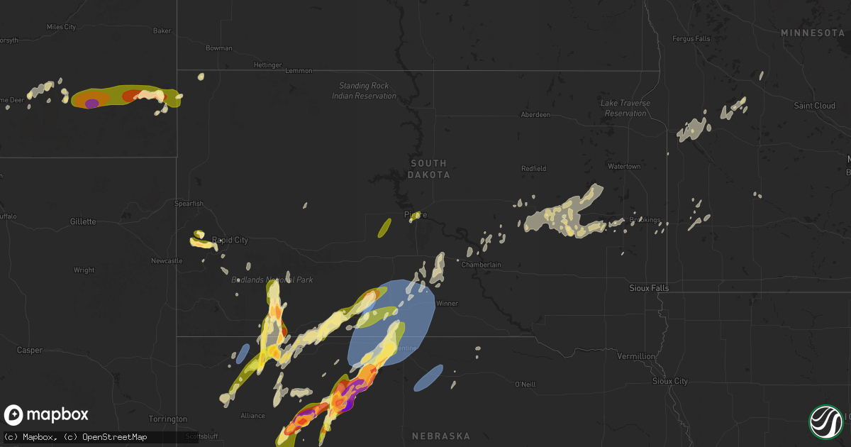
Hail Map in South Dakota on April 27, 2025
Get this storm
April 27 map
$229
one time, instant access
Download today. No call, no setup
Keep the $229
Bought the map and want the full workflow? Apply the entire $229 to a subscription within 7 days. None of it is wasted.
Every map, not just this one
This buys you this map. Subscription and you get every map we run, in the markets you choose from a few cities to whole states to nationwide. Plus real-time alerts the moment a storm fires.
Contact data
Name, contact info, occupancy, even credit band for addresses in the footprint. You go from where it hit to who to call.
Become the source they trust
Unlimited branding weather history reports on demand. You already have the documented answer ready for the property owner, and you are the one who showed up with it.
Property data and RoofTrace estimates
Pull up any address you have got, its value and the exact code rules for that jurisdiction, straight from One Click Code. Then RoofTrace estimates the squares, pitch, and roof value, priced the way you price.
Storm reports in South Dakota
South Dakota
| Date | Description |
|---|---|
| 04/27/20252:10 AM CDT | Mesonet station ocms2 oacoma 2w |
| 04/27/20251:15 AM CDT | A local report indicates 66 MPH wind near 1 S White River |
| 04/27/202512:57 AM CDT | A local report indicates 1.00 inch wind near Mission |
| 04/27/202512:50 AM CDT | A local report indicates 67 MPH wind near 7 ESE Rosebud |
| 04/27/202512:35 AM CDT | Trees down and roof damage. |
| 04/27/202512:32 AM CDT | A local report indicates 77 MPH wind near 6 W Parmelee |
| 04/26/202510:55 PM CDT | Most hail stones between nickel and quarter size. |
| 04/26/20259:15 PM CDT | A local report indicates 1.75 inch wind near 3 S Mystic |
| 04/26/20258:47 PM CDT | A local report indicates 1.50 inch wind near 3 NW Silver City |
| 04/26/20258:47 PM CDT | A local report indicates 1.50 inch wind near 7 WSW Nemo |
| 04/26/20258:40 PM CDT | A local report indicates 1.00 inch wind near 1 S Rockyford |
| 04/26/20258:00 PM CDT | A local report indicates 1.00 inch wind near 6 SE Oglala |
| 04/26/20258:00 PM CDT | A local report indicates 2.00 inch wind near Manderson |
| 04/26/20257:25 PM CDT | Golf ball sized hail reported in the wolf creek community. |
All States Impacted by Hail Map on April 27, 2025
Cities Impacted by Hail Map on April 27, 2025
- Robinsonville, MS
- Lake Cormorant, MS
- Hernando, MS
- Sarah, MS
- Coldwater, MS
- Senatobia, MS
- Clarksdale, MS
- Sledge, MS
- Como, MS
- Watson, AR
- Lambert, MS
- Kosciusko, MS
- Holt, FL
- Marks, MS
- Sardis, MS
- Kilmichael, MS
- French Camp, MS
- Batesville, MS
- Crestview, FL
- Tutwiler, MS
- Oxford, MS
- Taylor, MS
- Charleston, MS
- Ellabell, GA
- Brooklet, GA
- Baker, FL
- Tunica, MS
- Cascilla, MS
- Stewart, MS
- Enid, MS
- Pope, MS
- Guyton, GA
- Eupora, MS
- Milton, FL
- Water Valley, MS
- Tillatoba, MS
- Lisco, NE
- Lame Deer, MT
- Holcomb, MS
- Mathiston, MS
- Grenada, MS
- Scobey, MS
- Coffeeville, MS
- Philadelphia, MS
- Carthage, MS
- Ellsworth, NE
- Springfield, GA
- Oshkosh, NE
- Carrollton, MS
- Bruce, MS
- Union, MS
- Forsyth, MT
- Pittsboro, MS
- Houlka, MS
- Randolph, MS
- Vardaman, MS
- McCarley, MS
- Calhoun City, MS
- Lakeside, NE
- Derma, MS
- Houston, MS
- Pontotoc, MS
- Winona, MS
- Duck Hill, MS
- Blackshear, GA
- Alma, GA
- Mershon, GA
- Fort Valley, GA
- Bingham, NE
- Hyannis, NE
- Rushville, NE
- Decatur, MS
- Dothan, AL
- Little Rock, MS
- Byron, GA
- Bristol, GA
- Hay Springs, NE
- Lubbock, TX
- Uvalda, GA
- Slaton, TX
- Ransom Canyon, TX
- Patterson, GA
- Idalou, TX
- Otter, MT
- Volborg, MT
- Hickory, MS
- Chunky, MS
- Vidalia, GA
- Ashby, NE
- Lorenzo, TX
- Cordele, GA
- Morton, MS
- Lena, MS
- Lyons, GA
- Chadron, NE
- Merriman, NE
- Pine Ridge, SD
- Whitman, NE
- Lodge Grass, MT
- Busby, MT
- Olive, MT
- Broadus, MT
- Batesland, SD
- Arthur, NE
- Manderson, SD
- Saint Xavier, MT
- Garryowen, MT
- Wounded Knee, SD
- Forest, MS
- Collins, GA
- Porcupine, SD
- Crow Agency, MT
- Pulaski, MS
- Kyle, SD
- Powderville, MT
- Gordon, NE
- Hemingford, NE
- Hill City, SD
- Lead, SD
- Cody, NE
- Biddle, MT
- Valentine, NE
- Whitney, NE
- Alliance, NE
- Rapid City, SD
- Custer, SD
- Marsland, NE
- Paris, MS
- Mantee, MS
- Hermosa, SD
- Lenox, GA
- Tifton, GA
- Ekalaka, MT
- Boyes, MT
- Hammond, MT
- Fairburn, SD
- Keystone, SD
- Enigma, GA
- Cochran, GA
- Fitzgerald, GA
- Ocilla, GA
- Bridgeport, NE
- Mission, SD
- Buffalo Gap, SD
- Martin, SD
- Wray, GA
- Broadwater, NE
- White River, SD
- Wood, SD
- Alapaha, GA
- Kilgore, NE
- Crookston, NE
- Fort Pierre, SD
- Box Elder, SD
- Ambrose, GA
- Capitol, MT
- Tuthill, SD
- Wall, SD
- Pierre, SD
- Douglas, GA
- Saint Francis, SD
- Presho, SD
- Winner, SD
- Ideal, SD
- Okaton, SD
- Witten, SD
- Draper, SD
- Kennebec, SD
- Camp Crook, SD
- Buffalo, SD
- Parmelee, SD
- Norris, SD
- Long Valley, SD
- Lower Brule, SD
- Reliance, SD
- Rosebud, SD
- Fort Thompson, SD
- Chamberlain, SD
- Gann Valley, SD
- Nenzel, NE
- Sparks, NE
- Okreek, SD
- Miller, SD
- Saint Lawrence, SD
- Wessington, SD
- Long Pine, NE
- Ainsworth, NE
- Wessington Springs, SD
- Hoboken, GA
- Fall Creek, WI
- Alpena, SD
- Huron, SD
- Virgil, SD
- Wolsey, SD
- Hitchcock, SD
- Johnstown, NE
- Wood Lake, NE
- Iroquois, SD
- Artesian, SD
- Cavour, SD
- Bassett, NE
- Mills, NE
- Carthage, SD
- Yale, SD
- Fedora, SD
- Carpenter, SD
- Willow Lake, SD
- De Smet, SD
- Oldham, SD
- Bryant, SD
- Howard, SD
- Arlington, SD
- Lake Preston, SD
- Ramona, SD
- Vienna, SD
- Nunda, SD
- Neillsville, WI
- Volga, SD
- Brookings, SD
- Bruce, SD
- Elkton, SD
- Flandreau, SD
- Lake Benton, MN
- Marietta, MN
- Bellingham, MN
- Ruthton, MN
- Tyler, MN
- Appleton, MN
- Correll, MN
- Ortonville, MN
- Madison, MN
- Odessa, MN
- Long Prairie, MN
- Osakis, MN
- Lynd, MN
- Minneota, MN
- Holloway, MN
- Taunton, MN
- Russell, MN
- Balaton, MN
- Hancock, MN
- Morris, MN
- Ghent, MN
- Clontarf, MN
- Benson, MN
- Marshall, MN
- Tracy, MN
- Danvers, MN
- Starbuck, MN
- Glenwood, MN
- Brooten, MN
- Morton, MN
- Madison, SD
- Redwood Falls, MN
- Floydada, TX


