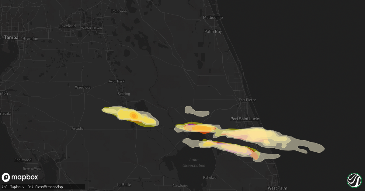
Hail Map in Okeechobee, FL on April 27, 2015
Get this storm
April 27 map
$229
one time, instant access
Download today. No call, no setup
Keep the $229
Bought the map and want the full workflow? Apply the entire $229 to a subscription within 7 days. None of it is wasted.
Every map, not just this one
This buys you this map. Subscription and you get every map we run, in the markets you choose from a few cities to whole states to nationwide. Plus real-time alerts the moment a storm fires.
Contact data
Name, contact info, occupancy, even credit band for addresses in the footprint. You go from where it hit to who to call.
Become the source they trust
Unlimited branding weather history reports on demand. You already have the documented answer ready for the property owner, and you are the one who showed up with it.
Property data and RoofTrace estimates
Pull up any address you have got, its value and the exact code rules for that jurisdiction, straight from One Click Code. Then RoofTrace estimates the squares, pitch, and roof value, priced the way you price.
Storm reports in Okeechobee, FL
Okeechobee, FL
| Date | Description |
|---|---|
| 04/27/20154:47 PM CDT | A trained spotter southeast of taylor creek in okeechobee reported golf-ball sized hail at their residence. |
| 04/27/20154:35 PM CDT | Broadcast media wptv reports quarter-sized hail at a car dealership near the intersection of sw 32nd st. And us-441 in okeechobee. |
All Cities Impacted by Hail Map on April 27, 2015
- Abbeville, LA
- Hollywood, FL
- Cross Plains, TX
- Burkett, TX
- Brownwood, TX
- May, TX
- Rising Star, TX
- Vernon, TX
- Belle Rose, LA
- Pierre Part, LA
- Port Sulphur, LA
- Braithwaite, LA
- Maringouin, LA
- Grosse Tete, LA
- Saint Martinville, LA
- Egan, LA
- Rayne, LA
- Crowley, LA
- Hobe Sound, FL
- Stuart, FL
- Palm City, FL
- Sulphur, LA
- Lake Placid, FL
- Maurice, LA
- Opelousas, LA
- Creole, LA
- Grand Chenier, LA
- San Saba, TX
- Lampasas, TX
- Bend, TX
- Richland Springs, TX
- Lometa, TX
- New Iberia, LA
- Bell City, LA
- Oakdale, LA
- Okeechobee, FL
- Evant, TX
- Rotonda West, FL
- Englewood, FL
- Port Charlotte, FL
- Placida, FL
- Bunkie, LA
- Washington, LA
- Palmetto, LA
- Plaucheville, LA
- Batchelor, LA
- Saint Francisville, LA
- Melville, LA
- Hineston, LA
- Rochelle, TX
- Kenner, LA
- Ponchatoula, LA
- Westwego, LA
- Sebring, FL
- Gonzales, LA
- Geismar, LA
- Saint Amant, LA
- Sorrento, LA
- Port Allen, LA
- Prairieville, LA
- Sunshine, LA
- Saint Gabriel, LA
- Addis, LA
- Baton Rouge, LA
- Buna, TX
- Silsbee, TX
- Call, TX
- Merryville, LA
- Elton, LA
- Kinder, LA
- Thibodaux, LA
- Des Allemands, LA
- Orange, TX
- Dequincy, LA
- Kirbyville, TX
- Newton, TX
- Port Arthur, TX
- Nederland, TX
- Beaumont, TX
- Crandall, TX
- Ferris, TX
- Seagoville, TX
- Kaufman, TX
- Denham Springs, LA
- Brusly, LA
- Plaquemine, LA
- Iowa, LA
- Fred, TX
- Spurger, TX
- Iota, LA
- Indiantown, FL
- Ama, LA
- Groves, TX
- Lafitte, LA
- Belle Chasse, LA
- Port Neches, TX
- Port Barre, LA
- Erath, LA
- Jeanerette, LA
- White Castle, LA
- Napoleonville, LA
- Luling, LA
- Barataria, LA
- Paradis, LA
- Boutte, LA
- Raceland, LA
- Marrero, LA
- Hahnville, LA
- Cameron, LA
- Hackberry, LA
- Lake Charles, LA
- Ville Platte, LA
- Lorida, FL
- Pitkin, LA
- Dry Creek, LA
- Basile, LA
- Jupiter, FL
- Deridder, LA
- Broaddus, TX
- Dulac, LA
- Simmesport, LA
- Morganza, LA
- Lottie, LA
- Oberlin, LA
- Krotz Springs, LA
- Saint Landry, LA
- Lettsworth, LA
- Fordoche, LA
- Morrow, LA
- Eunice, LA
- Glenmora, LA
- Mittie, LA
- Ragley, LA
- Reeves, LA
- Singer, LA
- Vinton, LA
- Bridge City, TX
- Golden Meadow, LA
- Franklin, LA
- Zolfo Springs, FL
- Arcadia, FL
- Broussard, LA
- Scott, LA
- Carencro, LA
- Lafayette, LA
- Breaux Bridge, LA
- Duson, LA
- Jennings, LA
- Evangeline, LA
- Loreauville, LA
- Plattenville, LA
- Donaldsonville, LA
- Branch, LA
- Waxahachie, TX
- Red Oak, TX
- Palmer, TX
- Scurry, TX
- Sugartown, LA
- Hemphill, TX
- Westlake, LA
- Church Point, LA
- Oscar, LA
- Livonia, LA
- Port Saint Lucie, FL
- Opa Locka, FL
- North Miami Beach, FL
- Miami, FL
- Miami Beach, FL
- Miami Gardens, FL
- Erwinville, LA
- Lakeland, LA
- Bon Wier, TX
- Kountze, TX
- Buras, LA
- Springfield, LA
- Holden, LA
- Livingston, LA
- Gatesville, TX
- Gibson, LA
- Schriever, LA
- Morgan City, LA
- Jensen Beach, FL
- Jackson, LA
- Hialeah, FL
- Hallandale, FL
- Pembroke Pines, FL
- Fort Lauderdale, FL
- Lancaster, TX
- New Orleans, LA
- French Settlement, LA
- Pineland, TX
- Theriot, LA
- Montegut, LA
- Chauvin, LA
- Houma, LA
- Larose, LA
- Galliano, LA
- North Port, FL
- Saint Rose, LA
- Metairie, LA
- Baldwin, LA
- Bronson, TX
- Kaplan, LA
- Saint James, LA
- Saint Bernard, LA
- Labadieville, LA
- Welsh, LA
- Arnaudville, LA
- Mamou, LA
- Longville, LA
- Sunset, LA
- Greenwell Springs, LA
- Carville, LA
- Estherwood, LA
- Youngsville, LA
- Delcambre, LA
- Morse, LA
- Rosedale, LA
- Roanoke, LA
- Bedias, TX
- Madisonville, TX
- Thornton, TX
- Maurepas, LA
- Anacoco, LA
- Florien, LA
- Starks, LA
- Coral Springs, FL
- Pompano Beach, FL


