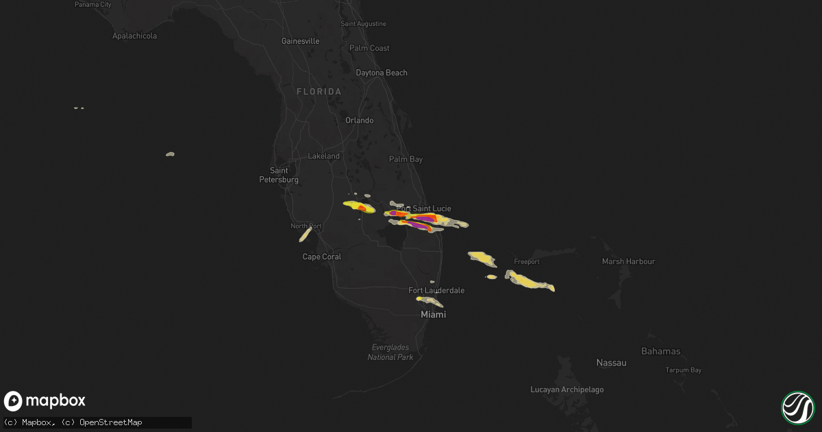
Hail Map on April 27, 2015
Get this storm
April 27 map
$229
one time, instant access
Download today. No call, no setup
Keep the $229
Bought the map and want the full workflow? Apply the entire $229 to a subscription within 7 days. None of it is wasted.
Every map, not just this one
This buys you this map. Subscription and you get every map we run, in the markets you choose from a few cities to whole states to nationwide. Plus real-time alerts the moment a storm fires.
Contact data
Name, contact info, occupancy, even credit band for addresses in the footprint. You go from where it hit to who to call.
Become the source they trust
Unlimited branding weather history reports on demand. You already have the documented answer ready for the property owner, and you are the one who showed up with it.
Property data and RoofTrace estimates
Pull up any address you have got, its value and the exact code rules for that jurisdiction, straight from One Click Code. Then RoofTrace estimates the squares, pitch, and roof value, priced the way you price.
Storm reports
Florida
| Date | Description |
|---|---|
| 04/27/20155:48 PM CDT | Tree and several large branches down. Time estimated based on radar. |
| 04/27/20155:40 PM CDT | Quarter-sized hail reported near the intersection of se osprey st. And se federal hwy us-1 in hobe sound. |
| 04/27/20155:40 PM CDT | Spotter estimates hail between 3/4 of an inch and 1 inch fell along se osceola st. And the st. Lucie river in stuart. |
| 04/27/20155:40 PM CDT | Cocorahs report of golf ball sized hail near the intersection of se cove road and us-1 se federal highway in stuart. Also reported...estimated wind speeds of 60 mph. |
| 04/27/20155:40 PM CDT | Spotter reports half-dollar sized hail near the intersection of sw salerno road and kanner hwy in palm city. |
| 04/27/20155:39 PM CDT | Report of a tree uprooted and fell onto a vehicle near the intersection of us-1 se federal highway and se indian st. In stuart. Person was temporarily trapped but was a |
| 04/27/20155:36 PM CDT | Spotter report of nickel to quarter sized hail near the intersection of se dixie highway and se st. Lucie blvd. |
| 04/27/20155:35 PM CDT | Trained spotter reports golf ball sized hail in stuart near the intersection of se cove road and se federal highway us-1. |
| 04/27/20155:35 PM CDT | Trained spotter reports golf ball sized hail in the pinelake gardens and estates subdivision in stuart. |
| 04/27/20155:35 PM CDT | Half-dollar sized hail reported by spotter about 1 mile east of intersection of i-95 and sw kanner hwy...exit 101. |
| 04/27/20155:35 PM CDT | Trained spotter reported nickel to quarter-sized hail near witham field airport. |
| 04/27/20155:33 PM CDT | Trained spotter just north of witham field airport in stuart reports half dollar sized hail. |
| 04/27/20155:30 PM CDT | Trained spotter reported quarter-sized hail about 1 mile ne of exit 133...sw martin hwy...on the florida turnpike. |
| 04/27/20155:29 PM CDT | A storm spotter reported quarter-sized hail falling near the intersection of sw high meadows avenue and sw martin avenue just east of the florida turnpike. |
| 04/27/20155:29 PM CDT | A trained spotter reported half-dollar sized hail at their residence just south of becker road along the c-23 canal. |
| 04/27/20155:20 PM CDT | Numerous storm spotter reports of hail varying in size from peas to as large as golf balls in the stuart...palm city...and port salerno area of martin county between 62 |
| 04/27/20155:10 PM CDT | Received a report from social media of quarter sized hail in pembroke pines. |
| 04/27/20154:58 PM CDT | An off duty nws employee reported quarter sized hail at pines blvd and sw 186th ave |
| 04/27/20154:57 PM CDT | A trained weather spotter reported quarter sized hail at 180th ave and pines blvd. |
| 04/27/20154:47 PM CDT | A trained spotter southeast of taylor creek in okeechobee reported golf-ball sized hail at their residence. |
| 04/27/20154:35 PM CDT | Broadcast media wptv reports quarter-sized hail at a car dealership near the intersection of sw 32nd st. And us-441 in okeechobee. |
| 04/27/20154:08 PM CDT | Highlands county sherrifs reported quarter to golf ball size hail in lake placid. Pictures on social media also show hail in the quarter to golf ball size range. |
| 04/27/20154:08 PM CDT | Highlands county sheriffs office reported numerous powerlines down in lake placid. |
Louisiana
| Date | Description |
|---|---|
| 04/27/20156:25 PM CDT | Near the port vincent area |
| 04/27/20153:45 PM CDT | A local report indicates 1.00 inch wind near 1 S KINDER |
| 04/27/201510:50 AM CDT | Coop observer recorded 66 mph gusts. |
| 04/27/201510:45 AM CDT | A few trees reported down and some awnings blown off buildings at belle chasse naval air station. |
| 04/27/201510:35 AM CDT | Emergency management and media report several rail cars blown off elevated rail approach to huey p long bridge. Time estimated. |
| 04/27/201510:30 AM CDT | Roof blown off house in kenner. |
| 04/27/201510:28 AM CDT | Wind gust to 61kt or 70 mph measured at new orleans armstrong airport. |
| 04/27/201510:23 AM CDT | Multiple trees and power poles uprooted...snapped...or bent over between duncan canal and the corner of w esplanade and loyola. Minor roof damage also occurred to sever |
| 04/27/201510:10 AM CDT | Trees and power lines down in bayou gauche...paradis and des allemands areas. Power poles snapped along highways la306 and la632. Time estimated. |
| 04/27/201510:10 AM CDT | Several trees and power pole reported down. Time estimated by radar |
| 04/27/201510:08 AM CDT | Nws damage survey found an ef0 tornado in the community of bayou gauche with 75 mph winds...max width of 50 yards...and a path length of 0.8 miles. Houses experienced d |
| 04/27/20159:45 AM CDT | Several power poles blown down. |
| 04/27/20159:43 AM CDT | Broadcast media reported roofs off several houses in the thibodaux area. |
| 04/27/20159:43 AM CDT | Nws survey of damage 2.5 ssw of chickbay found ef1 tornado with max estimated winds 90 mph...path length 0.5 miles...and max width 75 yards. Tree damage...some uprooted |
| 04/27/20159:40 AM CDT | Several trees down in houma area |
| 04/27/20159:40 AM CDT | Tornado visually sighted by sheriffs office personnel. This is likely the same report that was surveyed by nws 4 miles north of thibodaux or 2.5 miles ssw of chickbay. |
| 04/27/20159:40 AM CDT | Front door blown off of a commerical business on choctaw drive. |
| 04/27/20159:40 AM CDT | Large tree limbs and one large tree downed by thunderstorm wind gusts |
| 04/27/20159:30 AM CDT | Trees reported down in multiple locations across iberville parish. |
| 04/27/20159:30 AM CDT | Numerous trees down near julia rd |
| 04/27/20159:30 AM CDT | Thunderstorm wind gusts downed large limbs and trees in several communities in ascension parish. Four homes were damaged by fallen trees. |
| 04/27/20159:28 AM CDT | Max estimated winds 85 mph... Rated ef-0. Path length 0.8 miles... Max width 75 yards. Large tree branches snapped and trees uprooted. |
| 04/27/20159:20 AM CDT | Large tree down on an apartment at tiger bend road |
| 04/27/20159:20 AM CDT | *** 1 inj *** large tree branches and isolated trees were blown down in scattered areas across baton rouge. A man was injured when a tree fell onto the automobile he wa |
| 04/27/20159:20 AM CDT | Trees and power lines blown down in many communities in assumption parish. Some houses with roof damage. At current time most concentrated damage in the napoleonville a |
| 04/27/20159:16 AM CDT | Sheriffs dept reports tree down and debris on road on chitimacha trail. |
| 04/27/20159:15 AM CDT | Max estimated winds 100 mph... Rated ef-1. Path length 0.65 miles... Max width 150 yards. Home damage and snapped hardwood trees. A carport was destroyed on one home an |
| 04/27/20159:13 AM CDT | Sheriffs dept reports tree down. |
| 04/27/20159:10 AM CDT | Approximately 10 power poles damaged along la highway 1. Time estimated by radar |
| 04/27/20159:10 AM CDT | Approximately 10 power poles damaged along la highway 1. Time estimated by radar |
| 04/27/20159:05 AM CDT | Tree down on hwy 87. |
| 04/27/20158:45 AM CDT | Trees blown down in several areas of pointe coupee parish. Three houses and two vehicles damaged by fallen trees. Time estimated from radar. |
| 04/27/20158:42 AM CDT | Sheriffs dept reports telephone pole down on house. |
| 04/27/20158:41 AM CDT | Tree reported down on i-10 blocking west bound traffic. |
| 04/27/20158:31 AM CDT | Pd reports tree down on grant and south main st. |
| 04/27/20158:26 AM CDT | A local report indicates 60 MPH wind near LAFAYETTE |
| 04/27/20158:22 AM CDT | Tree down on power line. Tree on fire. |
| 04/27/20158:18 AM CDT | Tree down in williana. |
| 04/27/20158:06 AM CDT | Report from lsu ag center crowley. |
| 04/27/20158:05 AM CDT | Trees down in pollock. |
| 04/27/20158:05 AM CDT | Spotter reports tree down on abbeville hwy. |
| 04/27/20158:03 AM CDT | Several trees reported down in the crowley area. |
| 04/27/20157:52 AM CDT | Trees and power lines down throughout the parish. |
| 04/27/20157:50 AM CDT | Trees and power lines down throughout the parish. |
| 04/27/20157:47 AM CDT | Power poles down |
| 04/27/20157:47 AM CDT | Power lines down |
| 04/27/20157:33 AM CDT | Power poles down |
| 04/27/20157:27 AM CDT | Trees down |
| 04/27/20157:19 AM CDT | Roof removed from a trailer home in lebleu settlement. Time estimated by radar. |
| 04/27/20157:15 AM CDT | Power pole down near sj welsh middle school. |
| 04/27/20157:13 AM CDT | A roughly 12 inch in diameter live oak blown over in hackberry. Picure received through facebook. |
| 04/27/20157:05 AM CDT | Trees down in much of the parish. |
Texas
| Date | Description |
|---|---|
| 04/27/20156:12 PM CDT | Public posted photo of hail up to the size of quarters |
| 04/27/20156:03 PM CDT | Public posted photo of hail up to the size of quarters |
| 04/27/20156:03 PM CDT | Public reported hail up to the size of golf balls |
| 04/27/20155:53 PM CDT | Public posted photo of quarter sized hail |
| 04/27/20155:45 PM CDT | Media posted a photo of mainly penny and nickel size hail with a few hailstones up to quarter size |
| 04/27/20155:40 PM CDT | Public reported hail up to the size of golf balls |
| 04/27/20152:35 PM CDT | Public posted photo of measured one and a half inch hail |
| 04/27/20152:30 PM CDT | Public measured one and a quarter inch hail. |
| 04/27/20152:10 PM CDT | A local report indicates 1.00 inch wind near FRED |
| 04/26/20158:55 PM CDT | A local report indicates 1.75 inch wind near 6 SE SAN SABA |
| 04/26/20158:13 PM CDT | A local report indicates 1.00 inch wind near 4 WSW RICHLAND SPRINGS |
Cities Impacted by Hail Map on April 27, 2015
- Abbeville, LA
- Hollywood, FL
- Cross Plains, TX
- Burkett, TX
- Brownwood, TX
- May, TX
- Rising Star, TX
- Vernon, TX
- Belle Rose, LA
- Pierre Part, LA
- Port Sulphur, LA
- Braithwaite, LA
- Maringouin, LA
- Grosse Tete, LA
- Saint Martinville, LA
- Egan, LA
- Rayne, LA
- Crowley, LA
- Hobe Sound, FL
- Stuart, FL
- Palm City, FL
- Sulphur, LA
- Lake Placid, FL
- Maurice, LA
- Opelousas, LA
- Creole, LA
- Grand Chenier, LA
- San Saba, TX
- Lampasas, TX
- Bend, TX
- Richland Springs, TX
- Lometa, TX
- New Iberia, LA
- Bell City, LA
- Oakdale, LA
- Okeechobee, FL
- Evant, TX
- Rotonda West, FL
- Englewood, FL
- Port Charlotte, FL
- Placida, FL
- Bunkie, LA
- Washington, LA
- Palmetto, LA
- Plaucheville, LA
- Batchelor, LA
- Saint Francisville, LA
- Melville, LA
- Hineston, LA
- Rochelle, TX
- Kenner, LA
- Ponchatoula, LA
- Westwego, LA
- Sebring, FL
- Gonzales, LA
- Geismar, LA
- Saint Amant, LA
- Sorrento, LA
- Port Allen, LA
- Prairieville, LA
- Sunshine, LA
- Saint Gabriel, LA
- Addis, LA
- Baton Rouge, LA
- Buna, TX
- Silsbee, TX
- Call, TX
- Merryville, LA
- Elton, LA
- Kinder, LA
- Thibodaux, LA
- Des Allemands, LA
- Orange, TX
- Dequincy, LA
- Kirbyville, TX
- Newton, TX
- Port Arthur, TX
- Nederland, TX
- Beaumont, TX
- Crandall, TX
- Ferris, TX
- Seagoville, TX
- Kaufman, TX
- Denham Springs, LA
- Brusly, LA
- Plaquemine, LA
- Iowa, LA
- Fred, TX
- Spurger, TX
- Iota, LA
- Indiantown, FL
- Ama, LA
- Groves, TX
- Lafitte, LA
- Belle Chasse, LA
- Port Neches, TX
- Port Barre, LA
- Erath, LA
- Jeanerette, LA
- White Castle, LA
- Napoleonville, LA
- Luling, LA
- Barataria, LA
- Paradis, LA
- Boutte, LA
- Raceland, LA
- Marrero, LA
- Hahnville, LA
- Cameron, LA
- Hackberry, LA
- Lake Charles, LA
- Ville Platte, LA
- Lorida, FL
- Pitkin, LA
- Dry Creek, LA
- Basile, LA
- Jupiter, FL
- Deridder, LA
- Broaddus, TX
- Dulac, LA
- Simmesport, LA
- Morganza, LA
- Lottie, LA
- Oberlin, LA
- Krotz Springs, LA
- Saint Landry, LA
- Lettsworth, LA
- Fordoche, LA
- Morrow, LA
- Eunice, LA
- Glenmora, LA
- Mittie, LA
- Ragley, LA
- Reeves, LA
- Singer, LA
- Vinton, LA
- Bridge City, TX
- Golden Meadow, LA
- Franklin, LA
- Zolfo Springs, FL
- Arcadia, FL
- Broussard, LA
- Scott, LA
- Carencro, LA
- Lafayette, LA
- Breaux Bridge, LA
- Duson, LA
- Jennings, LA
- Evangeline, LA
- Loreauville, LA
- Plattenville, LA
- Donaldsonville, LA
- Branch, LA
- Waxahachie, TX
- Red Oak, TX
- Palmer, TX
- Scurry, TX
- Sugartown, LA
- Hemphill, TX
- Westlake, LA
- Church Point, LA
- Oscar, LA
- Livonia, LA
- Port Saint Lucie, FL
- Opa Locka, FL
- North Miami Beach, FL
- Miami, FL
- Miami Beach, FL
- Miami Gardens, FL
- Erwinville, LA
- Lakeland, LA
- Bon Wier, TX
- Kountze, TX
- Buras, LA
- Springfield, LA
- Holden, LA
- Livingston, LA
- Gatesville, TX
- Gibson, LA
- Schriever, LA
- Morgan City, LA
- Jensen Beach, FL
- Jackson, LA
- Hialeah, FL
- Hallandale, FL
- Pembroke Pines, FL
- Fort Lauderdale, FL
- Lancaster, TX
- New Orleans, LA
- French Settlement, LA
- Pineland, TX
- Theriot, LA
- Montegut, LA
- Chauvin, LA
- Houma, LA
- Larose, LA
- Galliano, LA
- North Port, FL
- Saint Rose, LA
- Metairie, LA
- Baldwin, LA
- Bronson, TX
- Kaplan, LA
- Saint James, LA
- Saint Bernard, LA
- Labadieville, LA
- Welsh, LA
- Arnaudville, LA
- Mamou, LA
- Longville, LA
- Sunset, LA
- Greenwell Springs, LA
- Carville, LA
- Estherwood, LA
- Youngsville, LA
- Delcambre, LA
- Morse, LA
- Rosedale, LA
- Roanoke, LA
- Bedias, TX
- Madisonville, TX
- Thornton, TX
- Maurepas, LA
- Anacoco, LA
- Florien, LA
- Starks, LA
- Coral Springs, FL
- Pompano Beach, FL