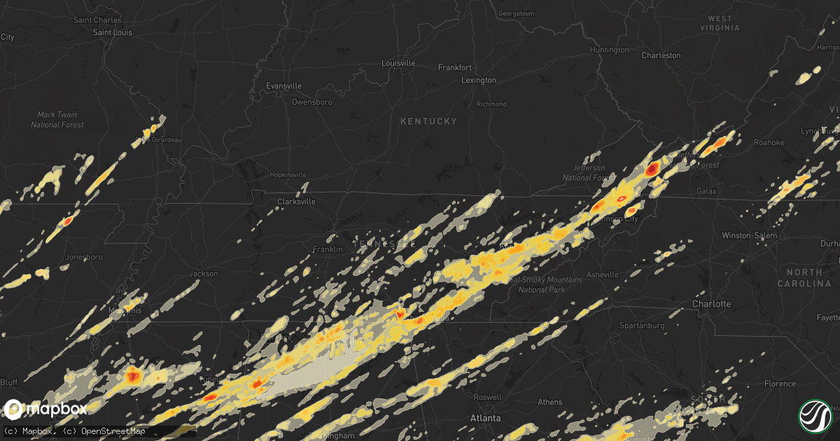
Hail Map in Virginia on April 27, 2011
Get this storm
April 27 map
$229
one time, instant access
Download today. No call, no setup
Keep the $229
Bought the map and want the full workflow? Apply the entire $229 to a subscription within 7 days. None of it is wasted.
Every map, not just this one
This buys you this map. Subscription and you get every map we run, in the markets you choose from a few cities to whole states to nationwide. Plus real-time alerts the moment a storm fires.
Contact data
Name, contact info, occupancy, even credit band for addresses in the footprint. You go from where it hit to who to call.
Become the source they trust
Unlimited branding weather history reports on demand. You already have the documented answer ready for the property owner, and you are the one who showed up with it.
Property data and RoofTrace estimates
Pull up any address you have got, its value and the exact code rules for that jurisdiction, straight from One Click Code. Then RoofTrace estimates the squares, pitch, and roof value, priced the way you price.
Storm reports in Virginia
Virginia
| Date | Description |
|---|---|
| 04/27/20116:59 PM CDT | Near shannon hill road |
| 04/27/20116:50 PM CDT | A local report indicates 1.00 inch wind near 5 ENE AXTON |
| 04/27/20116:45 PM CDT | A local report indicates 1.75 inch wind near COLUMBIA |
| 04/27/20116:35 PM CDT | A couple of trees down over the road near oakpark. |
| 04/27/20116:33 PM CDT | Tornado reported on the ground vicinty i64 and 295 |
| 04/27/20116:30 PM CDT | A local report indicates 1.00 inch wind near CHATHAM |
| 04/27/20116:25 PM CDT | Nws storm survey determined the damage was consistent with an ef1 tornado. Tornado track measured at approximately 100 yards wide. The tornado tracked from bridgewater |
| 04/27/20116:25 PM CDT | A local report indicates 2.00 inch wind near DRY FORK |
| 04/27/20116:15 PM CDT | 62 mph wind measured |
| 04/27/20116:13 PM CDT | At 541 whitmell school road |
| 04/27/20116:10 PM CDT | A local report indicates 1.75 inch wind near 4 S CUMBERLAND |
| 04/27/20116:05 PM CDT | Trees down on bollingbrook drive. |
| 04/27/20116:04 PM CDT | Two trees down over state farm boulevard. |
| 04/27/20116:03 PM CDT | Tree over scottsville road. |
| 04/27/20116:00 PM CDT | About 10 large oak trees blown down 1.5 miles east of route 53 and route 20 intersection. |
| 04/27/20116:00 PM CDT | Nws storm survey determined damage consistent with an ef-1 tornado. Tornado track measured at approximately 150 yards wide and 5.5 miles long. A more detailed prelimina |
| 04/27/20116:00 PM CDT | One inch hail |
| 04/27/20115:50 PM CDT | Approximately six trees and numerous large tree limbs down |
| 04/27/20115:50 PM CDT | Approximately six trees and numerous large tree limbs down |
| 04/27/20115:44 PM CDT | A local report indicates 1.00 inch wind near BALLSVILLE |
| 04/27/20115:43 PM CDT | A local report indicates 1.75 inch wind near MACON |
| 04/27/20115:24 PM CDT | Large tree down across roadway in the dumfries and triangle area |
| 04/27/20115:20 PM CDT | A local report indicates 1.75 inch wind near AXTON |
| 04/27/20115:17 PM CDT | A local report indicates 1.50 inch wind near 1 NE DUMFRIES |
| 04/27/20115:16 PM CDT | Quarter size hail in dumfries |
| 04/27/20115:15 PM CDT | 3 to 5 minutes of hail up to quarter sized. |
| 04/27/20115:14 PM CDT | Reported by quantico observer 1 to 2 miles west of quantico. |
| 04/27/20115:12 PM CDT | Tree limbs about 15 to 17 inches in diameter were blown down. A christmas tree that was laying in the backyard was moved about 60 feet. A funnel cloud was also sited. |
| 04/27/20115:12 PM CDT | A local report indicates 1.50 inch wind near 1 W DUMFRIES |
| 04/27/20115:05 PM CDT | A local report indicates 1.25 inch wind near CONCORD |
| 04/27/20115:05 PM CDT | Quarter to half dollar size |
| 04/27/20115:05 PM CDT | A local report indicates 1.00 inch wind near RIDGEWAY |
| 04/27/20115:03 PM CDT | Near longwood university |
| 04/27/20114:50 PM CDT | A local report indicates 1.00 inch wind near 1 E FARMVILLE |
| 04/27/20114:45 PM CDT | Trees down. |
| 04/27/20113:58 PM CDT | In the 1600 block of hairfield lane |
| 04/27/20113:50 PM CDT | A local report indicates 1.00 inch wind near 1 W THORNHILL |
| 04/27/20113:00 PM CDT | Reported by effort baptist church. Quarter to half dollar size. |
| 04/27/20112:45 PM CDT | A local report indicates 1.00 inch wind near 1 NW SCOTTSVILLE |
| 04/27/20112:45 PM CDT | Tree down on scottsville road one mile north of scottsville. |
| 04/27/20111:11 PM CDT | 3 ft diameter tree blown down and knocked down power and phone lines |
| 04/27/20115:15 AM CDT | Several trees downed in the willis area...including on buffalo mountain rd. |
| 04/27/20114:16 AM CDT | Tree down on wires. |
| 04/27/20114:10 AM CDT | Roof gone... Side of house down at 430 boyers rd |
| 04/27/20112:56 AM CDT | Ef-1 tornado. Peak winds 90 mph. Path length 1.8 miles. Path width 150 yards. |
| 04/27/20112:45 AM CDT | Damage was observed along forest rd 59 where several large trees were uprooted or snapped. Several more trees were snapped or uprooted along several points of forest rd |
| 04/27/20112:45 AM CDT | Ef-0 tornado. Peak winds 70 mph. Path length 5.3 miles. Path width 175 yards. Tornado continued into frederick county. |
| 04/27/20112:44 AM CDT | Tree uprooted on hite lane. |
| 04/27/20112:30 AM CDT | Numerous trees down near natural bridge. Tree fell on a trailer in colen hollow. |
| 04/27/20112:01 AM CDT | Ef-1 tornado. Peak winds 90 mph. Path length 0.9 miles. Path width 50 yards. |
| 04/27/20112:00 AM CDT | Dozens of snapped and uprooted trees....and damage to houses on spring house circle. |
| 04/27/20111:49 AM CDT | A local report indicates 58 MPH wind near 1 WSW STRASBURG |
| 04/27/20111:46 AM CDT | A local report indicates 62 MPH wind near 2 ENE ALONZAVILLE |
| 04/27/20111:40 AM CDT | Several trees down in the indian valley area on roads and a couple of houses. |
| 04/27/20111:31 AM CDT | 4 mile track. Not yet rated. Numerous trees snapped or uprooted. Damage to several houses. Roofing removed on multiple residences. Several out buildings destroyed. |
| 04/27/20111:26 AM CDT | Numerous large trees uprooted and snapped on hidden spring ln. Damage to home across the street. |
| 04/27/20111:21 AM CDT | Trees down and structural damage to house. |
| 04/27/20111:16 AM CDT | Multiple trees down. Tops twisted off. |
| 04/27/20111:12 AM CDT | Large tree down and power lines down in the 15000 and 16000 block of little dry river road near fulks run... Va |
| 04/27/20111:00 AM CDT | Large tree down on potts mountain...route 311 |
| 04/27/201112:36 AM CDT | Numerous trees down near natural bridge. Tree fell on a trailer in colen hollow. |
| 04/27/201112:35 AM CDT | Tree down at intersection of mertens rd and oldtown orleans rd se |
| 04/27/201112:30 AM CDT | Several trees down in warm springs along sr 220 and along rocky ridge. |
| 04/27/201112:25 AM CDT | A local report indicates 1.00 inch wind near NEWPORT |
| 04/27/201112:20 AM CDT | A local report indicates 1.50 inch wind near PEMBROKE |
| 04/27/201112:20 AM CDT | A local report indicates 2.00 inch wind near 1 S POPLAR HILL |
| 04/27/201112:15 AM CDT | *** 1 inj *** a nws storm survey team concluded that a tornado entered smyth county from washington county at 115 am edt and lifted along carlock creek road near brushy |
| 04/27/201112:15 AM CDT | Public reported hen egg to tennis ball size hail in poplar hill. |
| 04/27/201112:15 AM CDT | A local report indicates 2.50 inch wind near 5 SSE PEARISBURG |
| 04/27/201112:15 AM CDT | Several trees reported downed in the rocky ridge area. Time estimated from radar. |
| 04/27/201112:10 AM CDT | A local report indicates 1.00 inch wind near PEARISBURG |
| 04/26/201111:55 PM CDT | A local report indicates 63 MPH wind near MAX MEADOWS |
| 04/26/201111:45 PM CDT | A local report indicates 2.00 inch wind near WHITE GATE |
| 04/26/201111:25 PM CDT | A local report indicates 1.25 inch wind near MARION |
| 04/26/201111:05 PM CDT | Power line blown down that took out power for most of the county |
| 04/26/201110:25 PM CDT | Relatively continuous tree damage was noted along a 1.1 mile track from sunset hills road to wiehle avenue near north shore drive and fairway drive. This tornado prelim |
| 04/26/201110:17 PM CDT | A local report indicates 1.75 inch wind near 1 SSE CHILHOWIE |
| 04/26/201110:17 PM CDT | A local report indicates 1.00 inch wind near CHILHOWIE |
| 04/26/201110:15 PM CDT | A local report indicates 1.00 inch wind near BLUEFIELD |
| 04/26/20119:57 PM CDT | Structural damage to retail shopping center. |
| 04/26/20119:51 PM CDT | Tree down near wittens mills |
| 04/26/20119:50 PM CDT | Tree down along route 460 eastbound near the intersection of route 781 |
| 04/26/20119:47 PM CDT | Corrected start location of track after damage survey today. Tornado was rated ef-1. Additional damage includes numerous snapped and uprooted trees...siding and shingle |
| 04/26/20119:46 PM CDT | Tree down on central avenue |
| 04/26/20119:45 PM CDT | Inside ceiling panels were blown out of harris teeter in bristow center |
| 04/26/20119:45 PM CDT | Tree blown onto power lines causing sparks |
| 04/26/20119:44 PM CDT | Tree down in thompson valley |
| 04/26/20119:32 PM CDT | Reports of numerous trees and large branches down in and around town |
| 04/26/20119:32 PM CDT | Reports of numerous trees and large branches down in and around town |
| 04/26/20119:30 PM CDT | Multiple trees down on lake park road. |
| 04/26/20119:30 PM CDT | Numerous trees down. |
| 04/26/20119:23 PM CDT | A local report indicates 1.00 inch wind near RICHLANDS |
| 04/26/20119:19 PM CDT | A local report indicates 1.25 inch wind near 10 N BRISTOL TN |
| 04/26/20119:15 PM CDT | Ef0. Just south of abingdon. Path length of 2 miles. Width was very narrow. Max winds of 75 mph. Damage was mainly limited to downed trees. |
| 04/26/20119:00 PM CDT | Trees down. |
| 04/26/20119:00 PM CDT | Fell along shop street in marion. |
| 04/26/20118:55 PM CDT | A local report indicates 1.75 inch wind near 7 NNE BRISTOL TN |
| 04/26/20118:45 PM CDT | A local report indicates 2.00 inch wind near 7 W BRISTOL VA |
| 04/26/20117:58 PM CDT | Possible tornado...in the ruther glen area south... Southwest of golansville. Numerous other reports of funnel clouds. |
| 04/26/20117:55 PM CDT | Nws storm survey determined damage consistent with an ef-1 tornado. Tornado track measured at approximately 100 yards wide. The tornado crossed jericho road...approxima |
| 04/26/20117:40 PM CDT | Two trees down along route 522. |
| 04/26/20117:32 PM CDT | Several trees down on route 7 in round hill |
| 04/26/20117:25 PM CDT | Nws storm survey determined damage consistent with an ef-1 tornado along a 2 mile long...100-150 yard wide path across eastern goochland and western hanover counties. A |
| 04/26/20117:15 PM CDT | Tornado on the ground near oilville...near i-64 and rte 617. |
| 04/26/20117:04 PM CDT | A local report indicates 1.00 inch wind near 3 ENE BLAIRS |
All States Impacted by Hail Map on April 27, 2011
Cities Impacted by Hail Map on April 27, 2011
- Sweetwater, TN
- Dadeville, AL
- Lafayette, AL
- Camp Hill, AL
- Whitley City, KY
- Griffin, GA
- Tennessee Ridge, TN
- Cumberland City, TN
- Dover, TN
- Maben, MS
- Pheba, MS
- Mathiston, MS
- Eupora, MS
- New Market, TN
- Dandridge, TN
- Jefferson City, TN
- Kodak, TN
- Coudersport, PA
- Lock Haven, PA
- Knoxville, TN
- Hixson, TN
- Bloomsburg, PA
- Coahoma, MS
- Clarksdale, MS
- Friars Point, MS
- Dundee, MS
- Hickory, MS
- Salley, SC
- Pelion, SC
- Wagener, SC
- Batesburg, SC
- Leesville, SC
- Sardis, GA
- Penrose, NC
- Hendersonville, NC
- Cedar Mountain, NC
- Pisgah Forest, NC
- Brevard, NC
- Rosman, NC
- Kellyton, AL
- Moro, AR
- Marianna, AR
- Barnesville, GA
- Hillsboro, GA
- Milner, GA
- Zebulon, GA
- Molena, GA
- Forsyth, GA
- Jackson, GA
- Yatesville, GA
- Meansville, GA
- Juliette, GA
- Monticello, GA
- Thomaston, GA
- The Rock, GA
- Aiken, SC
- Ridge Spring, SC
- Monetta, SC
- Hollywood, AL
- Fackler, AL
- Concord, VA
- Appomattox, VA
- Lynchburg, VA
- Evington, VA
- Rustburg, VA
- Louisville, TN
- Maryville, TN
- Greenback, TN
- Friendsville, TN
- Farragut, TN
- Lenoir City, TN
- Fulks Run, VA
- Bergton, VA
- Sewanee, TN
- Sherwood, TN
- Tazewell, VA
- Huntsville, TN
- Pioneer, TN
- Oneida, TN
- Cohocton, NY
- Deer Lodge, TN
- Sunbright, TN
- Lancing, TN
- Doniphan, MO
- Fremont, MO
- Catlett, VA
- Mount Hope, WV
- Batesville, MS
- Tutwiler, MS
- Taylor, MS
- Lambert, MS
- Pope, MS
- Enid, MS
- Oakland, MS
- Water Valley, MS
- Sardis, MS
- Courtland, MS
- Oxford, MS
- Paris, MS
- Prospect, TN
- Mosheim, TN
- Greeneville, TN
- Parrottsville, TN
- Del Rio, TN
- Salisbury, NC
- Tallassee, AL
- Coffee Springs, AL
- Chancellor, AL
- Enterprise, AL
- Cleveland, AR
- Russellville, AR
- Center Ridge, AR
- Atkins, AR
- Hattieville, AR
- Clinton, AR
- Scotland, AR
- Jerusalem, AR
- Bee Branch, AR
- Damascus, AR
- Quitman, AR
- Menlo, GA
- Chickamauga, GA
- Marion Junction, AL
- Uniontown, AL
- Safford, AL
- Austin, PA
- Benezett, PA
- Emporium, PA
- Houston, MS
- Cullman, AL
- Horton, AL
- Guntersville, AL
- Blountsville, AL
- Holly Pond, AL
- Hanceville, AL
- Albertville, AL
- Princeton, AL
- Hollytree, AL
- Scottsboro, AL
- Thorsby, AL
- Peterstown, WV
- Ballard, WV
- Trenton, KY
- Guthrie, KY
- Clarksville, TN
- Houlka, MS
- Okolona, MS
- Philadelphia, MS
- Carthage, MS
- Walnut Grove, MS
- Lewisburg, TN
- Vincent, AL
- Sterrett, AL
- Woodville, AL
- Grant, AL
- Vinemont, AL
- Gallion, AL
- Faunsdale, AL
- Meridian, MS
- Rose Hill, MS
- Enterprise, MS
- Graysville, TN
- Dayton, TN
- Pikeville, TN
- Adamsville, AL
- Mulga, AL
- Sulligent, AL
- Beaverton, AL
- Greenwood Springs, MS
- Detroit, AL
- Hamilton, AL
- Cornersville, TN
- Belfast, TN
- Winslow, AR
- Kingsport, TN
- Fall Branch, TN
- Rogersville, TN
- Cleveland, TN
- Chattanooga, TN
- Rohwer, AR
- Beulah, MS
- Benoit, MS
- Cleveland, MS
- Harriet, AR
- Hustontown, PA
- McConnellsburg, PA
- Fort Littleton, PA
- Needmore, PA
- Three Springs, PA
- Harrisonville, PA
- Crossville, TN
- Sparta, TN
- Kilmichael, MS
- Damascus, VA
- Laurel Bloomery, TN
- Rockford, TN
- Loudon, TN
- Seymour, TN
- Strawberry Plains, TN
- Sevierville, TN
- Estill Springs, TN
- Winchester, TN
- Kelso, TN
- Flintville, TN
- Mulberry, TN
- Belvidere, TN
- Williamsburg, KY
- Bland, VA
- Ochlocknee, GA
- De Kalb, MS
- Broseley, MO
- Poplar Bluff, MO
- Fisk, MO
- Eagle Rock, VA
- Altenburg, MO
- Jackson, MO
- Wedgefield, SC
- Pinewood, SC
- Charlotte Court House, VA
- Randolph, VA
- Brookneal, VA
- Nathalie, VA
- Biglerville, PA
- Pulaski, VA
- Pound, VA
- Mcminnville, TN
- Shannon, MS
- Baxter, TN
- Cedarbluff, MS
- West Point, MS
- Prairie, MS
- Russellville, AL
- Mount Hope, AL
- Spring City, TN
- Rockwood, TN
- Eutaw, AL
- Woodbridge, VA
- Palmyra, VA
- Scottsville, VA
- Lexington, SC
- Gaston, SC
- Opelika, AL
- Staffordsville, VA
- Pearisburg, VA
- Russellville, KY
- Olmstead, KY
- Athens, AL
- Elora, TN
- Wappapello, MO
- Harviell, MO
- Puxico, MO
- Williamsville, MO
- Naylor, MO
- Oxly, MO
- Fairdealing, MO
- Berlin, PA
- Murfreesboro, TN
- Readyville, TN
- Christiana, TN
- Beechgrove, TN
- Bradyville, TN
- Danville, VA
- Dry Fork, VA
- Axton, VA
- Madison, AL
- Valhermoso Springs, AL
- Huntsville, AL
- Collierville, TN
- Bell Buckle, TN
- Keeling, VA
- Blairs, VA
- Leopold, MO
- Burfordville, MO
- Marble Hill, MO
- Cape Girardeau, MO
- Wolf Lake, IL
- Whitewater, MO
- Grand Tower, IL
- Nettleton, MS
- Atkins, VA
- Ceres, VA
- Marion, VA
- Grovetown, GA
- Augusta, GA
- Evans, GA
- Thomson, GA
- Harlem, GA
- Dearing, GA
- Appling, GA
- Clarks Hill, SC
- Spout Spring, VA
- Quincy, FL
- Westville, FL
- Geneva, AL
- Keezletown, VA
- Whitwell, TN
- Palmer, TN
- Tracy City, TN
- Lookout Mountain, TN
- Rossville, GA
- Harrison, TN
- Bryant, AL
- Lookout Mountain, GA
- Whiteside, TN
- Flintstone, GA
- Wildwood, GA
- Guild, TN
- Trenton, GA
- South Pittsburg, TN
- Biggers, AR
- Pocahontas, AR
- Narrows, VA
- Tuscaloosa, AL
- Ralph, AL
- Buhl, AL
- Coker, AL
- Fosters, AL
- Forest, MS
- Berry, AL
- Fayette, AL
- Signal Mountain, TN
- North Augusta, SC
- Sparta, GA
- Mount Vernon, AR
- Greenbrier, AR
- Rose Bud, AR
- Heber Springs, AR
- Oak Ridge, TN
- Clinton, TN
- Pounding Mill, VA
- Meadowview, VA
- Cedar Bluff, VA
- Glade Spring, VA
- Tannersville, VA
- Saltville, VA
- High Point, NC
- Kernersville, NC
- Colfax, NC
- Pansey, AL
- Gordon, AL
- Elkmont, AL
- Fayetteville, TN
- Millen, GA
- Putney, KY
- Loyall, KY
- Harlan, KY
- Ages Brookside, KY
- Evarts, KY
- Bledsoe, KY
- Baxter, KY
- Oakman, AL
- Pleasant Plains, AR
- Toney, AL
- Harvest, AL
- Hazel Green, AL
- New Market, AL
- West Fork, AR
- Tennille, GA
- Sandersville, GA
- Winfield, TN
- Memphis, TN
- Maplesville, AL
- Clanton, AL
- Ider, AL
- Banks, AR
- Star City, AR
- Wilmar, AR
- Rison, AR
- New Edinburg, AR
- Warren, AR
- Morganton, NC
- Hector, AR
- Columbia, TN
- Stevenson, AL
- East Freedom, PA
- Hollidaysburg, PA
- Duncansville, PA
- Ringgold, GA
- Fort Oglethorpe, GA
- Alton, MO
- Fulton, MS
- Tremont, MS
- Vina, AL
- Camden, SC
- Lugoff, SC
- York, AL
- Ward, AL
- Pelsor, AR
- Lamar, AR
- Paris, AR
- Hartman, AR
- Mount Judea, AR
- Ozone, AR
- Clarksville, AR
- Coal Hill, AR
- Hagarville, AR
- Cordova, AL
- Jasper, AL
- Florence, MS
- Fort Payne, AL
- Rainsville, AL
- Phil Campbell, AL
- Bear Creek, AL
- Oliver Springs, TN
- Wartburg, TN
- Lenoir, NC
- Hackleburg, AL
- Craigsville, VA
- Goshen, VA
- Wytheville, VA
- New Paris, PA
- Rapidan, VA
- Culpeper, VA
- Locust Dale, VA
- Oilville, VA
- Powhatan, VA
- Maidens, VA
- Rockville, VA
- Cumberland, VA
- Goochland, VA
- Crozier, VA
- State Farm, VA
- Marianna, FL
- Knoxville, AL
- Valley Head, AL
- Mentone, AL
- Henagar, AL
- Princeton, WV
- Glen Lyn, VA
- Rich Creek, VA
- Defuniak Springs, FL
- Spotsylvania, VA
- Fredericksburg, VA
- Locust Grove, VA
- Farmville, VA
- Amelia Court House, VA
- Hampden Sydney, VA
- Rice, VA
- Petersburg, TN
- Pulaski, TN
- Shelbyville, TN
- Lynnville, TN
- Hillsboro, AL
- Eastover, SC
- Hopkins, SC
- Olive Branch, MS
- Hudson, NC
- Jasper, TN
- Sequatchie, TN
- Aberdeen, MS
- Alexander City, AL
- Eclectic, AL
- Quitman, MS
- Booneville, AR
- Fort Smith, AR
- Charleston, AR
- Branch, AR
- Athens, TN
- Pickens, AR
- Dumas, AR
- Lindside, WV
- Greenville, WV
- Madison Heights, VA
- Petersburg, PA
- Warrenton, VA
- West Point, GA
- Dublin, VA
- Judsonia, AR
- Pangburn, AR
- Bradford, AR
- Oil Trough, AR
- Wilburn, AR
- Port Gibson, MS
- Lorman, MS
- Beech Creek, PA
- Renovo, PA
- Smithville, TN
- Columbia, SC
- Elizabethton, TN
- Byram, MS
- Terry, MS
- Winfield, AL
- Eldridge, AL
- Abingdon, VA
- Dothan, AL
- Pontotoc, MS
- Thaxton, MS
- Bristol, TN
- Bluff City, TN
- Jackson, SC
- Wartrace, TN
- Tullahoma, TN
- Cave City, AR
- Sulphur Rock, AR
- Marks, MS
- Moulton, AL
- Marshall, AR
- Norfork, AR
- Calico Rock, AR
- Flippin, AR
- Eatonton, GA
- Union, WV
- Chester, AR
- Carrollton, MS
- Greenwood, MS
- Demopolis, AL
- Livingston, AL
- Cleveland, GA
- Blountville, TN
- Mitchell, GA
- Maynard, AR
- Liverpool, PA
- Dalmatia, PA
- Millersburg, PA
- Adairsville, GA
- White, GA
- Centre, AL
- Newport, AR
- Inverness, MS
- Como, MS
- Lagrange, GA
- Elgin, SC
- Mill Spring, MO
- Brandon, MS
- Pulaski, MS
- Raleigh, MS
- Pelahatchie, MS
- Morton, MS
- Doswell, VA
- Montpelier, VA
- Beaverdam, VA
- Ruther Glen, VA
- Westport, PA
- Milledgeville, GA
- Haddock, GA
- Chapel Hill, TN
- Staunton, VA
- Swoope, VA
- Black, AL
- Slocomb, AL
- Graceville, FL
- Hartford, AL
- Bonifay, FL
- Town Creek, AL
- Holcomb, MS
- Grenada, MS
- Saluda, SC
- Ninety Six, SC
- Charleston, TN
- Braxton, MS
- Pearl, MS
- Richland, MS
- Imboden, AR
- Powhatan, AR
- Smithville, AR
- Lynn, AR
- Black Rock, AR
- Lauderdale, MS
- Toomsuba, MS
- Lynn, AL
- Haleyville, AL
- Florence, AL
- Iron City, TN
- Killen, AL
- North Bend, PA
- Waynesboro, GA
- Bristol, VA
- Gordonsville, VA
- Keswick, VA
- Adona, AR
- Morrilton, AR
- Perry, AR
- Birmingham, AL
- Pinson, AL
- Ringgold, VA
- Vernon Hill, VA
- Java, VA
- Chatham, VA
- Schellsburg, PA
- Friedens, PA
- Central City, PA
- Ridgeway, VA
- Eden, NC
- Helenwood, TN
- Rugby, TN
- Newcomb, TN
- Robbins, TN
- Counce, TN
- Michie, TN
- Savannah, TN
- Fayetteville, AR
- Briceville, TN
- Ashville, AL
- Waverly, AL
- Jakin, GA
- Donalsonville, GA
- Nokesville, VA
- Utica, MS
- Hermanville, MS
- Bean Station, TN
- Morristown, TN
- Leoma, TN
- Lawrenceburg, TN
- Carrollton, AL
- Ardmore, TN
- Bascom, FL
- Greenwood, FL
- Sneads, FL
- Port Matilda, PA
- Golden, MS
- Millerstown, PA
- Hampshire, TN
- Mount Pleasant, TN
- McGehee, AR
- Culleoka, TN
- Madera, PA
- West Decatur, PA
- Olanta, PA
- Osceola Mills, PA
- Houtzdale, PA
- Saint Joe, AR
- Pembroke, VA
- Ripplemead, VA
- Eggleston, VA
- Waverly, TN
- Stewart, TN
- Covington, GA
- Mcdonough, GA
- Social Circle, GA
- Herndon, PA
- Gibson, GA
- Avera, GA
- Philipsburg, PA
- Crenshaw, MS
- Calhoun, TN
- Ooltewah, TN
- Riceville, TN
- McDonald, TN
- Stapleton, GA
- Boligee, AL
- Smithville, MS
- Vernon, AL
- Orange, VA
- Elizabeth, AR
- Viola, AR
- Walland, TN
- Akron, AL
- Sawyerville, AL
- Millington, TN
- Cuthbert, GA
- Newton, MS
- Dahlonega, GA
- Suches, GA
- Thomasville, GA
- Tuscumbia, AL
- Senatobia, MS
- Gepp, AR
- Sturkie, AR
- Moody, MO
- Dolph, AR
- West Plains, MO
- Mountain Home, AR
- Mill Hall, PA
- Fork Union, VA
- Parrish, AL
- White Sulphur Springs, WV
- Lexington, AL
- Rogersville, AL
- Anderson, AL
- Brilliant, AL
- New Albany, MS
- Ecru, MS
- Blue Springs, MS
- Decatur, MS
- Stilwell, OK
- Grandin, MO
- Norwood, GA
- Shiloh, GA
- Salem, AL
- Hamilton, GA
- Pine Mountain, GA
- Valley, AL
- Cusseta, AL
- Pine Mountain Valley, GA
- Brickeys, AR
- Hughes, AR
- Tanner, AL
- Tyrone, GA
- Leighton, AL
- Muscle Shoals, AL
- Zalma, MO
- Warrenton, GA
- Crawfordville, GA
- Herndon, WV
- Rocky Gap, VA
- Jeffersonton, VA
- Success, AR
- Sharps Chapel, TN
- Cropwell, AL
- Pell City, AL
- Riverside, AL
- Alexandria, AL
- Ohatchee, AL
- Lincoln, AL
- Anniston, AL
- Gadsden, SC
- Orrville, AL
- Brush Creek, TN
- Wellington, AL
- Piedmont, AL
- Gadsden, AL
- Jacksonville, AL
- Wrens, GA
- Campbellton, FL
- Cottonwood, AL
- Columbia, VA
- Bremo Bluff, VA
- Arvonia, VA
- Louisa, VA
- Kents Store, VA
- Dunlap, TN
- Garrett, PA
- Highlands, NC
- Dillard, GA
- Scaly Mountain, NC
- Gretna, VA
- New Tazewell, TN
- Newport, TN
- Bybee, TN
- Shady Valley, TN
- Mountain City, TN
- Butler, TN
- Fort Blackmore, VA
- Dungannon, VA
- Nickelsville, VA
- McCormick, SC
- Lincolnton, GA
- Troy, SC
- Uniontown, AR
- Cedarville, AR
- Natural Dam, AR
- Cullen, VA
- Phenix, VA
- Clover, VA
- Couch, MO
- Van Buren, MO
- Kinston, AL
- Samson, AL
- Arab, AL
- Baileyton, AL
- Joppa, AL
- Union Grove, AL
- Eva, AL
- Hampton, GA
- Jamestown, TN
- Huntland, TN
- Dutton, AL
- Weiner, AR
- Cash, AR
- Grand Ridge, FL
- Tupelo, MS
- Evensville, TN
- Bigler, PA
- Woodland, PA
- New Millport, PA
- Clearfield, PA
- Wallaceton, PA
- Quebeck, TN
- Walling, TN
- Doyle, TN
- Spencer, TN
- Rock Island, TN
- Charlottesville, VA
- Troy, VA
- Stearns, KY
- Loretto, TN
- Logan, AL
- Goodwater, AL
- Morrison, TN
- Earle, AR
- Heth, AR
- Widener, AR
- Calhoun City, MS
- Vardaman, MS
- Sugar Grove, VA
- Chilhowie, VA
- Troutdale, VA
- Rural Retreat, VA
- Crockett, VA
- Meridianville, AL
- Spruce Pine, AL
- Somerville, AL
- Trinity, AL
- Decatur, AL
- Courtland, AL
- Danville, AL
- Amory, MS
- Hodges, AL
- Guin, AL
- Tichnor, AR
- Manchester, GA
- Warm Springs, GA
- Derma, MS
- Duck Hill, MS
- Gore Springs, MS
- Vaughan, MS
- Benton, MS
- Pickens, MS
- Gladys, VA
- Washington, GA
- Vaiden, MS
- Stewart, MS
- Winona, MS
- Toomsboro, GA
- Martinsville, VA
- Clayton, LA
- Sicily Island, LA
- Harrisonburg, LA
- Ferriday, LA
- Five Points, AL
- Ozark, AR
- Ratcliff, AR
- Magazine, AR
- Greensboro, NC
- Browns Summit, NC
- Myrtle, MS
- Ethel, MS
- Kosciusko, MS
- Monteagle, TN
- Forkland, AL
- Bellamy, AL
- Yazoo City, MS
- Swansea, SC
- Louisville, GA
- Sylacauga, AL
- Porum, OK
- Mellwood, AR
- Elaine, AR
- Sumter, SC
- Blacksburg, SC
- Smyrna, SC
- Rising Fawn, GA
- Silver Point, TN
- Mendenhall, MS
- Waynesboro, TN
- Greenwood, AR
- Tignall, GA
- Callands, VA
- Cascade, VA
- Stoneville, NC
- Grady, AR
- Monticello, AR
- Stanley, VA
- Luray, VA
- Greenville, MO
- Ellsinore, MO
- Rutledge, GA
- Mansfield, GA
- Marion, AL
- Beckley, WV
- Glen Daniel, WV
- Grassflat, PA
- Winburne, PA
- Morrisdale, PA
- Munson, PA
- Harriman, TN
- Rutledge, TN
- Chunky, MS
- Daleville, MS
- Louin, MS
- Cuba, AL
- Stonewall, MS
- Collinsville, MS
- Pachuta, MS
- Bailey, MS
- Marion, MS
- Madison, NC
- Mayodan, NC
- Byhalia, MS
- Nesbit, MS
- Southaven, MS
- Hernando, MS
- Holly Grove, AR
- Arlington, TN
- Aubrey, AR
- Marion, AR
- Atoka, TN
- Proctor, AR
- Clarendon, AR
- Drummonds, TN
- Munford, TN
- West Memphis, AR
- Lake Cormorant, MS
- Marvell, AR
- Mifflin, PA
- Chuckey, TN
- Double Springs, AL
- Laceys Spring, AL
- Plantersville, MS
- Mantachie, MS
- Aliceville, AL
- Newport, VA
- Boyle, MS
- Heflin, AL
- Decatur, TN
- Alligator, MS
- Duncan, MS
- Snow Lake, AR
- Watson, AR
- Alexandria, VA
- Fort Washington, MD
- Cherokee, AL
- Saint Joseph, TN
- Red Bay, AL
- Howard, PA
- Bellefonte, PA
- Tyler, AL
- Lowndesboro, AL
- Hayneville, AL
- Prattville, AL
- Manakin Sabot, VA
- Pamplin, VA
- Keysville, VA
- Lake, MS
- Brooks, GA
- Lawley, AL
- Bishopville, SC
- Ranburne, AL
- Bowdon, GA
- Silver Creek, GA
- Lindale, GA
- Rome, GA
- Cammal, PA
- Cedar Run, PA
- Waterville, PA
- Newnan, GA
- Grantville, GA
- Roanoke, AL
- Franklin, GA
- Hogansville, GA
- Gruetli Laager, TN
- Arley, AL
- Rockford, AL
- Equality, AL
- Cottondale, AL
- Fort Walton Beach, FL
- Mohawk, TN
- Midway, TN
- Hollandale, MS
- Monterey, TN
- Pleasant Hill, TN
- Dover, AR
- The Plains, VA
- Cartersville, GA
- Aragon, GA
- Kingston, GA
- Rome, PA
- Towanda, PA
- Ulster, PA
- Wysox, PA
- Osterburg, PA
- Imler, PA
- Brinson, GA
- Coldwater, MS
- Cogan Station, PA
- Trout Run, PA
- Jersey Shore, PA
- Triangle, VA
- Quantico, VA
- Stafford, VA
- Dumfries, VA
- Banner, MS
- Soddy Daisy, TN
- Tillar, AR
- McCarley, MS
- Moundville, AL
- Greensboro, AL
- Senoia, GA
- Greenville, GA
- Luthersville, GA
- Gay, GA
- Oark, AR
- Big Sandy, TN
- Hephzibah, GA
- Blythe, GA
- Matthews, GA
- Lancaster, TN
- Louisville, MS
- Preston, MS
- Bastian, VA
- Otto, NC
- Rabun Gap, GA
- Clayton, GA
- Gurley, AL
- Bremen, AL
- Rossville, TN
- Batesville, AR
- Butler, AL
- Madisonville, TN
- Georgetown, TN
- Vonore, TN
- Niota, TN
- Englewood, TN
- Owens Cross Roads, AL
- Paint Rock, AL
- New Hope, AL
- Trenton, AL
- Unicoi, TN
- Johnson City, TN
- Mooreville, MS
- Gilbert, SC
- Shady Spring, WV
- Hinton, WV
- Williamsport, TN
- Cave Spring, GA
- Cedartown, GA
- Lebanon, TN
- Jasper, GA
- Randolph, MS
- Drew, MS
- Mound Bayou, MS
- Parchman, MS
- Merigold, MS
- Gray, GA
- Wayland, NY
- Arkport, NY
- Avoca, NY
- Sallis, MS
- Middleburg, VA
- Granite Falls, NC
- Marietta, SC
- Hawk Run, PA
- Lanse, PA
- Karthaus, PA
- Drifting, PA
- Allport, PA
- Orviston, PA
- Snow Shoe, PA
- Kylertown, PA
- Clarence, PA
- Moshannon, PA
- Edgefield, SC
- White Plains, GA
- Camak, GA
- Modoc, SC
- Hiltons, VA
- Luttrell, TN
- Maynardville, TN
- Wetumpka, AL
- Titus, AL
- Mantee, MS
- Stanley, NC
- Mount Holly, NC
- Huntersville, NC
- Bridgeport, AL
- Bartow, GA
- Davisboro, GA
- Clarkrange, TN
- Lorton, VA
- North, SC
- Hampton, AR
- Magee, MS
- Oakdale, TN
- Centerville, TN
- Enola, AR
- Patrick, SC
- Saltillo, MS
- Linden, TN
- Hohenwald, TN
- Winchester, VA
- Hayden, AL
- Cleveland, AL
- Oneonta, AL
- Harrisville, MS
- Powell, TN
- Heiskell, TN
- Baldwyn, MS
- Booneville, MS
- Woodbury, TN
- Milton, TN
- Bruce, MS
- Big Creek, MS
- Coffeeville, MS
- Arkansas City, AR
- Dermott, AR
- Greensboro, GA
- Kingston, TN
- Townley, AL
- Orrtanna, PA
- Springville, AL
- Canton, GA
- Tillatoba, MS
- Trussville, AL
- Huntsville, AR
- Taylorsville, GA
- Walnut Cove, NC
- Pine Hall, NC
- Crawford, TN
- Wilder, TN
- Rickman, TN
- Allred, TN
- Alpine, TN
- Union Point, GA
- Rayle, GA
- Sutherlin, VA
- Julian, PA
- Lisman, AL
- Linden, AL
- Thomaston, AL
- Sweet Water, AL
- Jachin, AL
- Pennington, AL
- Harrisonburg, VA
- Shenandoah, VA
- Martinsburg, PA
- Fairmount, GA
- Talking Rock, GA
- Waleska, GA
- Blairsville, GA
- Ellijay, GA
- Dawsonville, GA
- Rydal, GA
- Ranger, GA
- Flat Rock, AL
- Millersville, MO
- Caledonia, MS
- Crystal Springs, MS
- Manchester, TN
- Mount Olive, AL
- Remlap, AL
- Graysville, AL
- Brookwood, AL
- Adger, AL
- Emelle, AL
- Ragland, AL
- Macon, MS
- Morris, AL
- Fairfield, AL
- Porterville, MS
- Docena, AL
- Vance, AL
- Odenville, AL
- Fultondale, AL
- Bessemer, AL
- Dolomite, AL
- Brookside, AL
- Pleasant Grove, AL
- Steele, AL
- Gardendale, AL
- Moody, AL
- Northport, AL
- Scooba, MS
- Aldie, VA
- Purcellville, VA
- Leesburg, VA
- Marshall, VA
- Frankewing, TN
- Auburntown, TN
- Watertown, TN
- Ashland, AL
- Lineville, AL
- Talladega, AL
- Muldrow, OK
- Partridge, KY
- Eolia, KY
- Lanett, AL
- Surgoinsville, TN
- Pigeon Forge, TN
- Decherd, TN
- Addison, AL
- Brownsboro, AL
- Squire, WV
- Honaker, VA
- Philadelphia, TN
- Lupton City, TN
- Ardmore, AL
- Gattman, MS
- Lebanon, VA
- Estillfork, AL
- Sale Creek, TN
- Russellville, TN
- Limestone, TN
- Alcoa, TN
- Grandview, TN
- Hartford, TN
- Mendota, VA
- Hamilton, MS
- Piney Flats, TN
- Nauvoo, AL
- Bandy, VA
- Ten Mile, TN
- Talbott, TN
- Etowah, TN
- Pisgah, AL
- Telford, TN
- Langston, AL
- Swords Creek, VA
- Afton, TN
- Bluefield, VA
- Crane Hill, AL
- Tallassee, TN
- Apison, TN
- Higdon, AL
- Jewell Ridge, VA
- Whitesburg, TN
- Townsend, TN
- Birchwood, TN
- Falkville, AL
- Reliance, TN
- Tellico Plains, TN
- Church Hill, TN
- Mascot, TN
- Broadford, VA
- Houston, AL
- Benton, TN
- Taft, TN
- Bulls Gap, TN
- Sheffield, AL
- North Carrollton, MS
- Jonesborough, TN
- Berwind, WV
- Cosby, TN
- Cowan, TN
- North Tazewell, VA
- Richlands, VA
- Delano, TN
- Mount Carmel, TN
- Ocoee, TN
- Section, AL
- Woodland, MS
- Castlewood, VA
- Gate City, VA
- Raven, VA
- White Pine, TN
- Rosedale, VA
- Cookeville, TN
- Newberry, SC
- Prosperity, SC
- Portland, IN
- Madison, GA
- Unionville, VA
- Lake Lure, NC
- Huntingdon, PA
- Centre Hall, PA
- Boalsburg, PA
- Elkins, AR
- Moreland, GA
- Buckingham, VA
- Blue Mountain, MS
- Dumas, MS
- Ripley, MS
- Welch, WV
- Northfork, WV
- Hickory, NC
- Connelly Springs, NC
- Empire, AL
- Unionville, TN
- Rockvale, TN
- Meadow Bridge, WV
- Wallins Creek, KY
- Closplint, KY
- Daviston, AL
- Westfield, NC
- Mountain Rest, SC
- Huntington, AR
- Ball Ground, GA
- Drasco, AR
- Locust Grove, AR
- Ida, AR
- Tumbling Shoals, AR
- Concord, AR
- Delta, AL
- Normandy, TN
- Marble Hill, GA
- Nebo, NC
- Marion, NC
- Six Mile Run, PA
- Saxton, PA
- Hopewell, PA
- Hartselle, AL
- Etta, MS
- Lena, MS
- Roaring Spring, PA
- Allensville, KY
- Collinsville, VA
- Thayer, MO
- Forrest City, AR
- Saint Matthews, SC
- Kings Mountain, NC
- Clover, SC
- Gastonia, NC
- Fairburn, GA
- Bluefield, WV
- Somerville, TN
- Whiteville, TN
- Medon, TN
- Mercer, TN
- Toone, TN
- Wadley, GA
- Belmont, MS
- McIntyre, GA
- Frenchville, PA
- Raymond, MS
- Camden, AL
- Girard, GA
- Midville, GA
- Perkins, GA
- Alexandria, TN
- Liberty, TN
- Mifflintown, PA
- West Columbia, SC
- Minor Hill, TN
- Lester, AL
- Oak Hill, WV
- Stanton, AL
- Newbern, AL
- Dellrose, TN
- Tunica, MS
- Allardt, TN
- Pine Knot, KY
- Lonoke, AR
- Pavo, GA
- Houston, AR
- Mountainburg, AR
- Belden, MS
- Rainbow City, AL
- Whitesville, WV
- Reidsville, NC
- Jacksons Gap, AL
- Gatlinburg, TN
- Duck River, TN
- Cairo, GA
- Woodbury, PA
- New Enterprise, PA
- Itta Bena, MS
- Moorhead, MS
- Stephens, GA
- Lexington, GA
- Taylorsville, NC
- Washburn, TN
- Hurt, VA
- Brentwood, TN
- Nashville, TN
- Franklin, TN
- Wesley, AR
- Haynes, AR
- Strawberry, AR
- Locust Grove, GA
- Dornsife, PA
- Webster Springs, WV
- Cowen, WV
- Crumrod, AR
- Stephens City, VA
- Middletown, VA
- Orbisonia, PA
- Churchville, VA
- Vance, MS
- Rosedale, MS
- Sumner, MS
- Abbeville, MS
- University, MS
- Charleston, MS
- Pall Mall, TN
- Jellico, TN
- Fayetteville, WV
- Goodman, MS
- West, MS
- Witts Springs, AR
- Chatsworth, GA
- Crandall, GA
- Corryton, TN
- Primm Springs, TN
- Santa Fe, TN
- Daleville, AL
- Newton, AL
- Midland City, AL
- Odd, WV
- Flat Top, WV
- Josephine, WV
- Cool Ridge, WV
- Ghent, WV
- Salem, AR
- Ruffin, NC
- Tuckasegee, NC
- Verona, MS
- West Blocton, AL
- Brent, AL
- Centreville, AL
- Clarkesville, GA
- Hayes, VA
- Chattahoochee, FL
- Geraldine, AL
- Collinsville, AL
- Dawson, AL
- Crossville, AL
- Richfield, PA
- McAlisterville, PA
- Lakemont, GA
- Long Creek, SC
- Tiger, GA
- Crawfordsville, AR
- Turrell, AR
- Gordon, GA
- Duncannon, PA
- Newport, PA
- South Boston, VA
- Halifax, VA
- Long Island, VA
- Remington, VA
- Hillsboro, TN
- Jersey Mills, PA
- Jewell, GA
- Concord, GA
- Murphysboro, IL
- Pomona, IL
- Shaw Afb, SC
- Williamson, GA
- Plum Branch, SC
- Shady Dale, GA
- Graniteville, SC
- Neeses, SC
- Keysville, GA
- Warthen, GA
- Woodbury, GA
- Dalzell, SC
- Blackville, SC
- Warrenville, SC
- Beech Island, SC
- Gloverville, SC
- Flovilla, GA
- Springfield, SC
- Williston, SC
- Johnston, SC
- Trenton, SC
- Rembert, SC
- Reform, AL
- Gordo, AL
- Palmetto, GA
- Lawrence, MS
- Waterproof, LA
- Georgetown, MS
- Blythewood, SC
- Weogufka, AL
- Ridgeville, IN
- Deerfield, VA
- Smyrna, TN
- Altavista, VA
- Lyon, MS
- McBee, SC
- Blacksburg, VA
- Macon, GA
- Ethridge, TN
- Summertown, TN
- Columbus, MS
- Steens, MS
- Jeffersonville, GA
- Dry Branch, GA
- Fort Eustis, VA
- Williamsburg, VA
- Ruth, MS
- Summit, MS
- Bogue Chitto, MS
- Union, SC
- Coldiron, KY
- La Fayette, GA
- Layland, WV
- Lookout, WV
- Glen Jean, WV
- Scarbro, WV
- Thurmond, WV
- Clifton, TN
- Linwood, NC
- Lexington, NC
- Brooksville, MS
- Autaugaville, AL
- Ward, SC
- Dowelltown, TN
- Kennedy, AL
- Bankston, AL
- Carbon Hill, AL
- Dora, AL
- Elrod, AL
- Appalachia, VA
- Trion, GA
- Starkville, MS
- Howardsville, VA
- Schuyler, VA
- Esmont, VA
- Notasulga, AL
- Butler, GA
- Morris, PA
- Pelham, NC
- Sugar Grove, WV
- Jonesboro, AR
- Montgomery, AL
- Pike Road, AL
- Fayetteville, GA
- Gould, AR
- Summerfield, NC
- Conway, AR
- Almyra, AR
- De Witt, AR
- Crocketts Bluff, AR
- Stuttgart, AR
- Cleveland, VA
- McGee, MO
- Sturdivant, MO
- Auburn, AL
- Thorn Hill, TN
- De Soto, IL
- Bainbridge, GA
- King, NC
- Jackson, TN
- Elmore, AL
- Deatsville, AL
- Pipestem, WV
- Forest Hill, WV
- Indian Mound, TN
- Ravenden, AR
- Helen, GA
- Hiawassee, GA
- Attalla, AL
- Rockmart, GA
- Tiplersville, MS
- Walnut, MS
- Cashiers, NC
- Glenville, NC
- Sharon, SC
- Cayce, SC
- Rocky Top, TN
- Andersonville, TN
- Pittsboro, MS
- Danbury, NC
- Warm Springs, VA
- Scranton, AR
- New Blaine, AR
- Siler, KY
- Buena Vista, TN
- Bruceton, TN
- Sallisaw, OK
- Olivehill, TN
- Jonesville, SC
- Honey Grove, PA
- Fort Belvoir, VA
- Richford, NY
- Canehill, AR
- Jayess, MS
- Monticello, MS
- Cassatt, SC
- Lincoln, AR
- Union City, GA
- Atlanta, GA
- Belspring, VA
- Poughkeepsie, AR
- Piedmont, MO
- Ellington, MO
- Craigsville, WV
- Richwood, WV
- Winchester, IN
- Farmland, IN
- Koshkonong, MO
- Chelsea, AL
- Montevallo, AL
- Pelham, AL
- Brierfield, AL
- Alabaster, AL
- Harpersville, AL
- Columbiana, AL
- Wilsonville, AL
- Romance, AR
- Strunk, KY
- Neelyville, MO
- Stigler, OK
- Whitefield, OK
- Richardsville, VA
- Helena, AR
- Gunnison, MS
- Shelby, MS
- Thida, AR
- Tuckerman, AR
- Wadley, AL
- Mississippi State, MS
- Whigham, GA
- Gladstone, VA
- Ridgeway, SC
- Sebring, FL
- Gainesboro, TN
- Broad Top, PA
- Todd, PA
- Cobbs Creek, VA
- Mathews, VA
- Bethune, SC
- Linden, PA
- Hesston, PA
- James Creek, PA
- Sautee Nacoochee, GA
- Williston, TN
- Lascassas, TN
- Boomer, NC
- Moravian Falls, NC
- Millport, AL
- Liberty, PA
- Blossburg, PA
- Tompkinsville, KY
- Summer Shade, KY
- Mount Hermon, KY
- Iuka, MS
- Tishomingo, MS
- Bradley, SC
- Wingina, VA
- Powder Springs, TN
- Windsor, SC
- Winston Salem, NC
- Elba, AL
- Birch Tree, MO
- Sharpsburg, GA
- Red House, VA
- Buckhead, GA
- Selma, AL
- Plumerville, AR
- Springfield, AR
- Denmark, TN
- Oakland, TN
- Moscow, TN
- Port Trevorton, PA
- Lynchburg, TN
- Shuqualak, MS
- Paulding, MS
- Benton, IL
- Harrison, GA
- Irwinton, GA
- Calhoun, GA
- Plainville, GA
- Woodland, AL
- Graham, AL
- Searcy, AR
- Bealeton, VA


