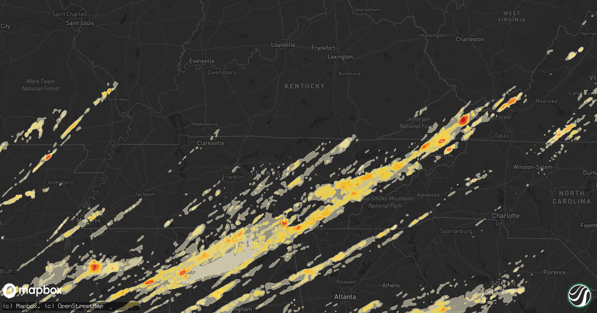
Hail Map in Missouri on April 27, 2011
Get this storm
April 27 map
$229
one time, instant access
Download today. No call, no setup
Keep the $229
Bought the map and want the full workflow? Apply the entire $229 to a subscription within 7 days. None of it is wasted.
Every map, not just this one
This buys you this map. Subscription and you get every map we run, in the markets you choose from a few cities to whole states to nationwide. Plus real-time alerts the moment a storm fires.
Contact data
Name, contact info, occupancy, even credit band for addresses in the footprint. You go from where it hit to who to call.
Become the source they trust
Unlimited branding weather history reports on demand. You already have the documented answer ready for the property owner, and you are the one who showed up with it.
Property data and RoofTrace estimates
Pull up any address you have got, its value and the exact code rules for that jurisdiction, straight from One Click Code. Then RoofTrace estimates the squares, pitch, and roof value, priced the way you price.
Storm reports in Missouri
Missouri
| Date | Description |
|---|---|
| 04/27/20114:22 PM CDT | Ten inch cherry snapped above the ground at highway ff and highway 61. |
| 04/27/20114:10 PM CDT | A local report indicates a tornado near 2 W CHAFFEE |
| 04/27/20114:00 PM CDT | Late report...trees down with some twisted at the base. One tree fell on a home causing structural damage. Event occurred off of highway 61 near fruitland. |
| 04/27/20112:55 PM CDT | Trees down |
| 04/27/20112:30 PM CDT | A local report indicates 65 MPH wind near ELLSINORE |
| 04/27/20112:03 PM CDT | A local report indicates 1.00 inch wind near JACKSON |
| 04/27/20112:00 PM CDT | A local report indicates 1.75 inch wind near FRUITLAND |
| 04/27/20111:59 PM CDT | A local report indicates 1.00 inch wind near FRUITLAND |
| 04/27/20111:58 PM CDT | A local report indicates 1.50 inch wind near JACKSON |
| 04/27/20111:54 PM CDT | A local report indicates 1.00 inch wind near JACKSON |
| 04/27/20111:30 PM CDT | Dime to quarter size hail |
| 04/27/20111:10 PM CDT | At wappapello dam from corps of engineers |
| 04/27/20111:00 PM CDT | A local report indicates 1.75 inch wind near 5 N POPLAR BLUFF |
| 04/27/20111:00 PM CDT | A local report indicates 1.75 inch wind near FRUITLAND |
| 04/27/201112:59 PM CDT | Northwest side of poplar bluff at highway 67 and barron road |
| 04/27/201112:45 PM CDT | A local report indicates 1.00 inch wind near FAIRDEALING |
All States Impacted by Hail Map on April 27, 2011
Cities Impacted by Hail Map on April 27, 2011
- Sweetwater, TN
- Dadeville, AL
- Lafayette, AL
- Camp Hill, AL
- Whitley City, KY
- Griffin, GA
- Tennessee Ridge, TN
- Cumberland City, TN
- Dover, TN
- Maben, MS
- Pheba, MS
- Mathiston, MS
- Eupora, MS
- New Market, TN
- Dandridge, TN
- Jefferson City, TN
- Kodak, TN
- Coudersport, PA
- Lock Haven, PA
- Knoxville, TN
- Hixson, TN
- Bloomsburg, PA
- Coahoma, MS
- Clarksdale, MS
- Friars Point, MS
- Dundee, MS
- Hickory, MS
- Salley, SC
- Pelion, SC
- Wagener, SC
- Batesburg, SC
- Leesville, SC
- Sardis, GA
- Penrose, NC
- Hendersonville, NC
- Cedar Mountain, NC
- Pisgah Forest, NC
- Brevard, NC
- Rosman, NC
- Kellyton, AL
- Moro, AR
- Marianna, AR
- Barnesville, GA
- Hillsboro, GA
- Milner, GA
- Zebulon, GA
- Molena, GA
- Forsyth, GA
- Jackson, GA
- Yatesville, GA
- Meansville, GA
- Juliette, GA
- Monticello, GA
- Thomaston, GA
- The Rock, GA
- Aiken, SC
- Ridge Spring, SC
- Monetta, SC
- Hollywood, AL
- Fackler, AL
- Concord, VA
- Appomattox, VA
- Lynchburg, VA
- Evington, VA
- Rustburg, VA
- Louisville, TN
- Maryville, TN
- Greenback, TN
- Friendsville, TN
- Farragut, TN
- Lenoir City, TN
- Fulks Run, VA
- Bergton, VA
- Sewanee, TN
- Sherwood, TN
- Tazewell, VA
- Huntsville, TN
- Pioneer, TN
- Oneida, TN
- Cohocton, NY
- Deer Lodge, TN
- Sunbright, TN
- Lancing, TN
- Doniphan, MO
- Fremont, MO
- Catlett, VA
- Mount Hope, WV
- Batesville, MS
- Tutwiler, MS
- Taylor, MS
- Lambert, MS
- Pope, MS
- Enid, MS
- Oakland, MS
- Water Valley, MS
- Sardis, MS
- Courtland, MS
- Oxford, MS
- Paris, MS
- Prospect, TN
- Mosheim, TN
- Greeneville, TN
- Parrottsville, TN
- Del Rio, TN
- Salisbury, NC
- Tallassee, AL
- Coffee Springs, AL
- Chancellor, AL
- Enterprise, AL
- Cleveland, AR
- Russellville, AR
- Center Ridge, AR
- Atkins, AR
- Hattieville, AR
- Clinton, AR
- Scotland, AR
- Jerusalem, AR
- Bee Branch, AR
- Damascus, AR
- Quitman, AR
- Menlo, GA
- Chickamauga, GA
- Marion Junction, AL
- Uniontown, AL
- Safford, AL
- Austin, PA
- Benezett, PA
- Emporium, PA
- Houston, MS
- Cullman, AL
- Horton, AL
- Guntersville, AL
- Blountsville, AL
- Holly Pond, AL
- Hanceville, AL
- Albertville, AL
- Princeton, AL
- Hollytree, AL
- Scottsboro, AL
- Thorsby, AL
- Peterstown, WV
- Ballard, WV
- Trenton, KY
- Guthrie, KY
- Clarksville, TN
- Houlka, MS
- Okolona, MS
- Philadelphia, MS
- Carthage, MS
- Walnut Grove, MS
- Lewisburg, TN
- Vincent, AL
- Sterrett, AL
- Woodville, AL
- Grant, AL
- Vinemont, AL
- Gallion, AL
- Faunsdale, AL
- Meridian, MS
- Rose Hill, MS
- Enterprise, MS
- Graysville, TN
- Dayton, TN
- Pikeville, TN
- Adamsville, AL
- Mulga, AL
- Sulligent, AL
- Beaverton, AL
- Greenwood Springs, MS
- Detroit, AL
- Hamilton, AL
- Cornersville, TN
- Belfast, TN
- Winslow, AR
- Kingsport, TN
- Fall Branch, TN
- Rogersville, TN
- Cleveland, TN
- Chattanooga, TN
- Rohwer, AR
- Beulah, MS
- Benoit, MS
- Cleveland, MS
- Harriet, AR
- Hustontown, PA
- McConnellsburg, PA
- Fort Littleton, PA
- Needmore, PA
- Three Springs, PA
- Harrisonville, PA
- Crossville, TN
- Sparta, TN
- Kilmichael, MS
- Damascus, VA
- Laurel Bloomery, TN
- Rockford, TN
- Loudon, TN
- Seymour, TN
- Strawberry Plains, TN
- Sevierville, TN
- Estill Springs, TN
- Winchester, TN
- Kelso, TN
- Flintville, TN
- Mulberry, TN
- Belvidere, TN
- Williamsburg, KY
- Bland, VA
- Ochlocknee, GA
- De Kalb, MS
- Broseley, MO
- Poplar Bluff, MO
- Fisk, MO
- Eagle Rock, VA
- Altenburg, MO
- Jackson, MO
- Wedgefield, SC
- Pinewood, SC
- Charlotte Court House, VA
- Randolph, VA
- Brookneal, VA
- Nathalie, VA
- Biglerville, PA
- Pulaski, VA
- Pound, VA
- Mcminnville, TN
- Shannon, MS
- Baxter, TN
- Cedarbluff, MS
- West Point, MS
- Prairie, MS
- Russellville, AL
- Mount Hope, AL
- Spring City, TN
- Rockwood, TN
- Eutaw, AL
- Woodbridge, VA
- Palmyra, VA
- Scottsville, VA
- Lexington, SC
- Gaston, SC
- Opelika, AL
- Staffordsville, VA
- Pearisburg, VA
- Russellville, KY
- Olmstead, KY
- Athens, AL
- Elora, TN
- Wappapello, MO
- Harviell, MO
- Puxico, MO
- Williamsville, MO
- Naylor, MO
- Oxly, MO
- Fairdealing, MO
- Berlin, PA
- Murfreesboro, TN
- Readyville, TN
- Christiana, TN
- Beechgrove, TN
- Bradyville, TN
- Danville, VA
- Dry Fork, VA
- Axton, VA
- Madison, AL
- Valhermoso Springs, AL
- Huntsville, AL
- Collierville, TN
- Bell Buckle, TN
- Keeling, VA
- Blairs, VA
- Leopold, MO
- Burfordville, MO
- Marble Hill, MO
- Cape Girardeau, MO
- Wolf Lake, IL
- Whitewater, MO
- Grand Tower, IL
- Nettleton, MS
- Atkins, VA
- Ceres, VA
- Marion, VA
- Grovetown, GA
- Augusta, GA
- Evans, GA
- Thomson, GA
- Harlem, GA
- Dearing, GA
- Appling, GA
- Clarks Hill, SC
- Spout Spring, VA
- Quincy, FL
- Westville, FL
- Geneva, AL
- Keezletown, VA
- Whitwell, TN
- Palmer, TN
- Tracy City, TN
- Lookout Mountain, TN
- Rossville, GA
- Harrison, TN
- Bryant, AL
- Lookout Mountain, GA
- Whiteside, TN
- Flintstone, GA
- Wildwood, GA
- Guild, TN
- Trenton, GA
- South Pittsburg, TN
- Biggers, AR
- Pocahontas, AR
- Narrows, VA
- Tuscaloosa, AL
- Ralph, AL
- Buhl, AL
- Coker, AL
- Fosters, AL
- Forest, MS
- Berry, AL
- Fayette, AL
- Signal Mountain, TN
- North Augusta, SC
- Sparta, GA
- Mount Vernon, AR
- Greenbrier, AR
- Rose Bud, AR
- Heber Springs, AR
- Oak Ridge, TN
- Clinton, TN
- Pounding Mill, VA
- Meadowview, VA
- Cedar Bluff, VA
- Glade Spring, VA
- Tannersville, VA
- Saltville, VA
- High Point, NC
- Kernersville, NC
- Colfax, NC
- Pansey, AL
- Gordon, AL
- Elkmont, AL
- Fayetteville, TN
- Millen, GA
- Putney, KY
- Loyall, KY
- Harlan, KY
- Ages Brookside, KY
- Evarts, KY
- Bledsoe, KY
- Baxter, KY
- Oakman, AL
- Pleasant Plains, AR
- Toney, AL
- Harvest, AL
- Hazel Green, AL
- New Market, AL
- West Fork, AR
- Tennille, GA
- Sandersville, GA
- Winfield, TN
- Memphis, TN
- Maplesville, AL
- Clanton, AL
- Ider, AL
- Banks, AR
- Star City, AR
- Wilmar, AR
- Rison, AR
- New Edinburg, AR
- Warren, AR
- Morganton, NC
- Hector, AR
- Columbia, TN
- Stevenson, AL
- East Freedom, PA
- Hollidaysburg, PA
- Duncansville, PA
- Ringgold, GA
- Fort Oglethorpe, GA
- Alton, MO
- Fulton, MS
- Tremont, MS
- Vina, AL
- Camden, SC
- Lugoff, SC
- York, AL
- Ward, AL
- Pelsor, AR
- Lamar, AR
- Paris, AR
- Hartman, AR
- Mount Judea, AR
- Ozone, AR
- Clarksville, AR
- Coal Hill, AR
- Hagarville, AR
- Cordova, AL
- Jasper, AL
- Florence, MS
- Fort Payne, AL
- Rainsville, AL
- Phil Campbell, AL
- Bear Creek, AL
- Oliver Springs, TN
- Wartburg, TN
- Lenoir, NC
- Hackleburg, AL
- Craigsville, VA
- Goshen, VA
- Wytheville, VA
- New Paris, PA
- Rapidan, VA
- Culpeper, VA
- Locust Dale, VA
- Oilville, VA
- Powhatan, VA
- Maidens, VA
- Rockville, VA
- Cumberland, VA
- Goochland, VA
- Crozier, VA
- State Farm, VA
- Marianna, FL
- Knoxville, AL
- Valley Head, AL
- Mentone, AL
- Henagar, AL
- Princeton, WV
- Glen Lyn, VA
- Rich Creek, VA
- Defuniak Springs, FL
- Spotsylvania, VA
- Fredericksburg, VA
- Locust Grove, VA
- Farmville, VA
- Amelia Court House, VA
- Hampden Sydney, VA
- Rice, VA
- Petersburg, TN
- Pulaski, TN
- Shelbyville, TN
- Lynnville, TN
- Hillsboro, AL
- Eastover, SC
- Hopkins, SC
- Olive Branch, MS
- Hudson, NC
- Jasper, TN
- Sequatchie, TN
- Aberdeen, MS
- Alexander City, AL
- Eclectic, AL
- Quitman, MS
- Booneville, AR
- Fort Smith, AR
- Charleston, AR
- Branch, AR
- Athens, TN
- Pickens, AR
- Dumas, AR
- Lindside, WV
- Greenville, WV
- Madison Heights, VA
- Petersburg, PA
- Warrenton, VA
- West Point, GA
- Dublin, VA
- Judsonia, AR
- Pangburn, AR
- Bradford, AR
- Oil Trough, AR
- Wilburn, AR
- Port Gibson, MS
- Lorman, MS
- Beech Creek, PA
- Renovo, PA
- Smithville, TN
- Columbia, SC
- Elizabethton, TN
- Byram, MS
- Terry, MS
- Winfield, AL
- Eldridge, AL
- Abingdon, VA
- Dothan, AL
- Pontotoc, MS
- Thaxton, MS
- Bristol, TN
- Bluff City, TN
- Jackson, SC
- Wartrace, TN
- Tullahoma, TN
- Cave City, AR
- Sulphur Rock, AR
- Marks, MS
- Moulton, AL
- Marshall, AR
- Norfork, AR
- Calico Rock, AR
- Flippin, AR
- Eatonton, GA
- Union, WV
- Chester, AR
- Carrollton, MS
- Greenwood, MS
- Demopolis, AL
- Livingston, AL
- Cleveland, GA
- Blountville, TN
- Mitchell, GA
- Maynard, AR
- Liverpool, PA
- Dalmatia, PA
- Millersburg, PA
- Adairsville, GA
- White, GA
- Centre, AL
- Newport, AR
- Inverness, MS
- Como, MS
- Lagrange, GA
- Elgin, SC
- Mill Spring, MO
- Brandon, MS
- Pulaski, MS
- Raleigh, MS
- Pelahatchie, MS
- Morton, MS
- Doswell, VA
- Montpelier, VA
- Beaverdam, VA
- Ruther Glen, VA
- Westport, PA
- Milledgeville, GA
- Haddock, GA
- Chapel Hill, TN
- Staunton, VA
- Swoope, VA
- Black, AL
- Slocomb, AL
- Graceville, FL
- Hartford, AL
- Bonifay, FL
- Town Creek, AL
- Holcomb, MS
- Grenada, MS
- Saluda, SC
- Ninety Six, SC
- Charleston, TN
- Braxton, MS
- Pearl, MS
- Richland, MS
- Imboden, AR
- Powhatan, AR
- Smithville, AR
- Lynn, AR
- Black Rock, AR
- Lauderdale, MS
- Toomsuba, MS
- Lynn, AL
- Haleyville, AL
- Florence, AL
- Iron City, TN
- Killen, AL
- North Bend, PA
- Waynesboro, GA
- Bristol, VA
- Gordonsville, VA
- Keswick, VA
- Adona, AR
- Morrilton, AR
- Perry, AR
- Birmingham, AL
- Pinson, AL
- Ringgold, VA
- Vernon Hill, VA
- Java, VA
- Chatham, VA
- Schellsburg, PA
- Friedens, PA
- Central City, PA
- Ridgeway, VA
- Eden, NC
- Helenwood, TN
- Rugby, TN
- Newcomb, TN
- Robbins, TN
- Counce, TN
- Michie, TN
- Savannah, TN
- Fayetteville, AR
- Briceville, TN
- Ashville, AL
- Waverly, AL
- Jakin, GA
- Donalsonville, GA
- Nokesville, VA
- Utica, MS
- Hermanville, MS
- Bean Station, TN
- Morristown, TN
- Leoma, TN
- Lawrenceburg, TN
- Carrollton, AL
- Ardmore, TN
- Bascom, FL
- Greenwood, FL
- Sneads, FL
- Port Matilda, PA
- Golden, MS
- Millerstown, PA
- Hampshire, TN
- Mount Pleasant, TN
- McGehee, AR
- Culleoka, TN
- Madera, PA
- West Decatur, PA
- Olanta, PA
- Osceola Mills, PA
- Houtzdale, PA
- Saint Joe, AR
- Pembroke, VA
- Ripplemead, VA
- Eggleston, VA
- Waverly, TN
- Stewart, TN
- Covington, GA
- Mcdonough, GA
- Social Circle, GA
- Herndon, PA
- Gibson, GA
- Avera, GA
- Philipsburg, PA
- Crenshaw, MS
- Calhoun, TN
- Ooltewah, TN
- Riceville, TN
- McDonald, TN
- Stapleton, GA
- Boligee, AL
- Smithville, MS
- Vernon, AL
- Orange, VA
- Elizabeth, AR
- Viola, AR
- Walland, TN
- Akron, AL
- Sawyerville, AL
- Millington, TN
- Cuthbert, GA
- Newton, MS
- Dahlonega, GA
- Suches, GA
- Thomasville, GA
- Tuscumbia, AL
- Senatobia, MS
- Gepp, AR
- Sturkie, AR
- Moody, MO
- Dolph, AR
- West Plains, MO
- Mountain Home, AR
- Mill Hall, PA
- Fork Union, VA
- Parrish, AL
- White Sulphur Springs, WV
- Lexington, AL
- Rogersville, AL
- Anderson, AL
- Brilliant, AL
- New Albany, MS
- Ecru, MS
- Blue Springs, MS
- Decatur, MS
- Stilwell, OK
- Grandin, MO
- Norwood, GA
- Shiloh, GA
- Salem, AL
- Hamilton, GA
- Pine Mountain, GA
- Valley, AL
- Cusseta, AL
- Pine Mountain Valley, GA
- Brickeys, AR
- Hughes, AR
- Tanner, AL
- Tyrone, GA
- Leighton, AL
- Muscle Shoals, AL
- Zalma, MO
- Warrenton, GA
- Crawfordville, GA
- Herndon, WV
- Rocky Gap, VA
- Jeffersonton, VA
- Success, AR
- Sharps Chapel, TN
- Cropwell, AL
- Pell City, AL
- Riverside, AL
- Alexandria, AL
- Ohatchee, AL
- Lincoln, AL
- Anniston, AL
- Gadsden, SC
- Orrville, AL
- Brush Creek, TN
- Wellington, AL
- Piedmont, AL
- Gadsden, AL
- Jacksonville, AL
- Wrens, GA
- Campbellton, FL
- Cottonwood, AL
- Columbia, VA
- Bremo Bluff, VA
- Arvonia, VA
- Louisa, VA
- Kents Store, VA
- Dunlap, TN
- Garrett, PA
- Highlands, NC
- Dillard, GA
- Scaly Mountain, NC
- Gretna, VA
- New Tazewell, TN
- Newport, TN
- Bybee, TN
- Shady Valley, TN
- Mountain City, TN
- Butler, TN
- Fort Blackmore, VA
- Dungannon, VA
- Nickelsville, VA
- McCormick, SC
- Lincolnton, GA
- Troy, SC
- Uniontown, AR
- Cedarville, AR
- Natural Dam, AR
- Cullen, VA
- Phenix, VA
- Clover, VA
- Couch, MO
- Van Buren, MO
- Kinston, AL
- Samson, AL
- Arab, AL
- Baileyton, AL
- Joppa, AL
- Union Grove, AL
- Eva, AL
- Hampton, GA
- Jamestown, TN
- Huntland, TN
- Dutton, AL
- Weiner, AR
- Cash, AR
- Grand Ridge, FL
- Tupelo, MS
- Evensville, TN
- Bigler, PA
- Woodland, PA
- New Millport, PA
- Clearfield, PA
- Wallaceton, PA
- Quebeck, TN
- Walling, TN
- Doyle, TN
- Spencer, TN
- Rock Island, TN
- Charlottesville, VA
- Troy, VA
- Stearns, KY
- Loretto, TN
- Logan, AL
- Goodwater, AL
- Morrison, TN
- Earle, AR
- Heth, AR
- Widener, AR
- Calhoun City, MS
- Vardaman, MS
- Sugar Grove, VA
- Chilhowie, VA
- Troutdale, VA
- Rural Retreat, VA
- Crockett, VA
- Meridianville, AL
- Spruce Pine, AL
- Somerville, AL
- Trinity, AL
- Decatur, AL
- Courtland, AL
- Danville, AL
- Amory, MS
- Hodges, AL
- Guin, AL
- Tichnor, AR
- Manchester, GA
- Warm Springs, GA
- Derma, MS
- Duck Hill, MS
- Gore Springs, MS
- Vaughan, MS
- Benton, MS
- Pickens, MS
- Gladys, VA
- Washington, GA
- Vaiden, MS
- Stewart, MS
- Winona, MS
- Toomsboro, GA
- Martinsville, VA
- Clayton, LA
- Sicily Island, LA
- Harrisonburg, LA
- Ferriday, LA
- Five Points, AL
- Ozark, AR
- Ratcliff, AR
- Magazine, AR
- Greensboro, NC
- Browns Summit, NC
- Myrtle, MS
- Ethel, MS
- Kosciusko, MS
- Monteagle, TN
- Forkland, AL
- Bellamy, AL
- Yazoo City, MS
- Swansea, SC
- Louisville, GA
- Sylacauga, AL
- Porum, OK
- Mellwood, AR
- Elaine, AR
- Sumter, SC
- Blacksburg, SC
- Smyrna, SC
- Rising Fawn, GA
- Silver Point, TN
- Mendenhall, MS
- Waynesboro, TN
- Greenwood, AR
- Tignall, GA
- Callands, VA
- Cascade, VA
- Stoneville, NC
- Grady, AR
- Monticello, AR
- Stanley, VA
- Luray, VA
- Greenville, MO
- Ellsinore, MO
- Rutledge, GA
- Mansfield, GA
- Marion, AL
- Beckley, WV
- Glen Daniel, WV
- Grassflat, PA
- Winburne, PA
- Morrisdale, PA
- Munson, PA
- Harriman, TN
- Rutledge, TN
- Chunky, MS
- Daleville, MS
- Louin, MS
- Cuba, AL
- Stonewall, MS
- Collinsville, MS
- Pachuta, MS
- Bailey, MS
- Marion, MS
- Madison, NC
- Mayodan, NC
- Byhalia, MS
- Nesbit, MS
- Southaven, MS
- Hernando, MS
- Holly Grove, AR
- Arlington, TN
- Aubrey, AR
- Marion, AR
- Atoka, TN
- Proctor, AR
- Clarendon, AR
- Drummonds, TN
- Munford, TN
- West Memphis, AR
- Lake Cormorant, MS
- Marvell, AR
- Mifflin, PA
- Chuckey, TN
- Double Springs, AL
- Laceys Spring, AL
- Plantersville, MS
- Mantachie, MS
- Aliceville, AL
- Newport, VA
- Boyle, MS
- Heflin, AL
- Decatur, TN
- Alligator, MS
- Duncan, MS
- Snow Lake, AR
- Watson, AR
- Alexandria, VA
- Fort Washington, MD
- Cherokee, AL
- Saint Joseph, TN
- Red Bay, AL
- Howard, PA
- Bellefonte, PA
- Tyler, AL
- Lowndesboro, AL
- Hayneville, AL
- Prattville, AL
- Manakin Sabot, VA
- Pamplin, VA
- Keysville, VA
- Lake, MS
- Brooks, GA
- Lawley, AL
- Bishopville, SC
- Ranburne, AL
- Bowdon, GA
- Silver Creek, GA
- Lindale, GA
- Rome, GA
- Cammal, PA
- Cedar Run, PA
- Waterville, PA
- Newnan, GA
- Grantville, GA
- Roanoke, AL
- Franklin, GA
- Hogansville, GA
- Gruetli Laager, TN
- Arley, AL
- Rockford, AL
- Equality, AL
- Cottondale, AL
- Fort Walton Beach, FL
- Mohawk, TN
- Midway, TN
- Hollandale, MS
- Monterey, TN
- Pleasant Hill, TN
- Dover, AR
- The Plains, VA
- Cartersville, GA
- Aragon, GA
- Kingston, GA
- Rome, PA
- Towanda, PA
- Ulster, PA
- Wysox, PA
- Osterburg, PA
- Imler, PA
- Brinson, GA
- Coldwater, MS
- Cogan Station, PA
- Trout Run, PA
- Jersey Shore, PA
- Triangle, VA
- Quantico, VA
- Stafford, VA
- Dumfries, VA
- Banner, MS
- Soddy Daisy, TN
- Tillar, AR
- McCarley, MS
- Moundville, AL
- Greensboro, AL
- Senoia, GA
- Greenville, GA
- Luthersville, GA
- Gay, GA
- Oark, AR
- Big Sandy, TN
- Hephzibah, GA
- Blythe, GA
- Matthews, GA
- Lancaster, TN
- Louisville, MS
- Preston, MS
- Bastian, VA
- Otto, NC
- Rabun Gap, GA
- Clayton, GA
- Gurley, AL
- Bremen, AL
- Rossville, TN
- Batesville, AR
- Butler, AL
- Madisonville, TN
- Georgetown, TN
- Vonore, TN
- Niota, TN
- Englewood, TN
- Owens Cross Roads, AL
- Paint Rock, AL
- New Hope, AL
- Trenton, AL
- Unicoi, TN
- Johnson City, TN
- Mooreville, MS
- Gilbert, SC
- Shady Spring, WV
- Hinton, WV
- Williamsport, TN
- Cave Spring, GA
- Cedartown, GA
- Lebanon, TN
- Jasper, GA
- Randolph, MS
- Drew, MS
- Mound Bayou, MS
- Parchman, MS
- Merigold, MS
- Gray, GA
- Wayland, NY
- Arkport, NY
- Avoca, NY
- Sallis, MS
- Middleburg, VA
- Granite Falls, NC
- Marietta, SC
- Hawk Run, PA
- Lanse, PA
- Karthaus, PA
- Drifting, PA
- Allport, PA
- Orviston, PA
- Snow Shoe, PA
- Kylertown, PA
- Clarence, PA
- Moshannon, PA
- Edgefield, SC
- White Plains, GA
- Camak, GA
- Modoc, SC
- Hiltons, VA
- Luttrell, TN
- Maynardville, TN
- Wetumpka, AL
- Titus, AL
- Mantee, MS
- Stanley, NC
- Mount Holly, NC
- Huntersville, NC
- Bridgeport, AL
- Bartow, GA
- Davisboro, GA
- Clarkrange, TN
- Lorton, VA
- North, SC
- Hampton, AR
- Magee, MS
- Oakdale, TN
- Centerville, TN
- Enola, AR
- Patrick, SC
- Saltillo, MS
- Linden, TN
- Hohenwald, TN
- Winchester, VA
- Hayden, AL
- Cleveland, AL
- Oneonta, AL
- Harrisville, MS
- Powell, TN
- Heiskell, TN
- Baldwyn, MS
- Booneville, MS
- Woodbury, TN
- Milton, TN
- Bruce, MS
- Big Creek, MS
- Coffeeville, MS
- Arkansas City, AR
- Dermott, AR
- Greensboro, GA
- Kingston, TN
- Townley, AL
- Orrtanna, PA
- Springville, AL
- Canton, GA
- Tillatoba, MS
- Trussville, AL
- Huntsville, AR
- Taylorsville, GA
- Walnut Cove, NC
- Pine Hall, NC
- Crawford, TN
- Wilder, TN
- Rickman, TN
- Allred, TN
- Alpine, TN
- Union Point, GA
- Rayle, GA
- Sutherlin, VA
- Julian, PA
- Lisman, AL
- Linden, AL
- Thomaston, AL
- Sweet Water, AL
- Jachin, AL
- Pennington, AL
- Harrisonburg, VA
- Shenandoah, VA
- Martinsburg, PA
- Fairmount, GA
- Talking Rock, GA
- Waleska, GA
- Blairsville, GA
- Ellijay, GA
- Dawsonville, GA
- Rydal, GA
- Ranger, GA
- Flat Rock, AL
- Millersville, MO
- Caledonia, MS
- Crystal Springs, MS
- Manchester, TN
- Mount Olive, AL
- Remlap, AL
- Graysville, AL
- Brookwood, AL
- Adger, AL
- Emelle, AL
- Ragland, AL
- Macon, MS
- Morris, AL
- Fairfield, AL
- Porterville, MS
- Docena, AL
- Vance, AL
- Odenville, AL
- Fultondale, AL
- Bessemer, AL
- Dolomite, AL
- Brookside, AL
- Pleasant Grove, AL
- Steele, AL
- Gardendale, AL
- Moody, AL
- Northport, AL
- Scooba, MS
- Aldie, VA
- Purcellville, VA
- Leesburg, VA
- Marshall, VA
- Frankewing, TN
- Auburntown, TN
- Watertown, TN
- Ashland, AL
- Lineville, AL
- Talladega, AL
- Muldrow, OK
- Partridge, KY
- Eolia, KY
- Lanett, AL
- Surgoinsville, TN
- Pigeon Forge, TN
- Decherd, TN
- Addison, AL
- Brownsboro, AL
- Squire, WV
- Honaker, VA
- Philadelphia, TN
- Lupton City, TN
- Ardmore, AL
- Gattman, MS
- Lebanon, VA
- Estillfork, AL
- Sale Creek, TN
- Russellville, TN
- Limestone, TN
- Alcoa, TN
- Grandview, TN
- Hartford, TN
- Mendota, VA
- Hamilton, MS
- Piney Flats, TN
- Nauvoo, AL
- Bandy, VA
- Ten Mile, TN
- Talbott, TN
- Etowah, TN
- Pisgah, AL
- Telford, TN
- Langston, AL
- Swords Creek, VA
- Afton, TN
- Bluefield, VA
- Crane Hill, AL
- Tallassee, TN
- Apison, TN
- Higdon, AL
- Jewell Ridge, VA
- Whitesburg, TN
- Townsend, TN
- Birchwood, TN
- Falkville, AL
- Reliance, TN
- Tellico Plains, TN
- Church Hill, TN
- Mascot, TN
- Broadford, VA
- Houston, AL
- Benton, TN
- Taft, TN
- Bulls Gap, TN
- Sheffield, AL
- North Carrollton, MS
- Jonesborough, TN
- Berwind, WV
- Cosby, TN
- Cowan, TN
- North Tazewell, VA
- Richlands, VA
- Delano, TN
- Mount Carmel, TN
- Ocoee, TN
- Section, AL
- Woodland, MS
- Castlewood, VA
- Gate City, VA
- Raven, VA
- White Pine, TN
- Rosedale, VA
- Cookeville, TN
- Newberry, SC
- Prosperity, SC
- Portland, IN
- Madison, GA
- Unionville, VA
- Lake Lure, NC
- Huntingdon, PA
- Centre Hall, PA
- Boalsburg, PA
- Elkins, AR
- Moreland, GA
- Buckingham, VA
- Blue Mountain, MS
- Dumas, MS
- Ripley, MS
- Welch, WV
- Northfork, WV
- Hickory, NC
- Connelly Springs, NC
- Empire, AL
- Unionville, TN
- Rockvale, TN
- Meadow Bridge, WV
- Wallins Creek, KY
- Closplint, KY
- Daviston, AL
- Westfield, NC
- Mountain Rest, SC
- Huntington, AR
- Ball Ground, GA
- Drasco, AR
- Locust Grove, AR
- Ida, AR
- Tumbling Shoals, AR
- Concord, AR
- Delta, AL
- Normandy, TN
- Marble Hill, GA
- Nebo, NC
- Marion, NC
- Six Mile Run, PA
- Saxton, PA
- Hopewell, PA
- Hartselle, AL
- Etta, MS
- Lena, MS
- Roaring Spring, PA
- Allensville, KY
- Collinsville, VA
- Thayer, MO
- Forrest City, AR
- Saint Matthews, SC
- Kings Mountain, NC
- Clover, SC
- Gastonia, NC
- Fairburn, GA
- Bluefield, WV
- Somerville, TN
- Whiteville, TN
- Medon, TN
- Mercer, TN
- Toone, TN
- Wadley, GA
- Belmont, MS
- McIntyre, GA
- Frenchville, PA
- Raymond, MS
- Camden, AL
- Girard, GA
- Midville, GA
- Perkins, GA
- Alexandria, TN
- Liberty, TN
- Mifflintown, PA
- West Columbia, SC
- Minor Hill, TN
- Lester, AL
- Oak Hill, WV
- Stanton, AL
- Newbern, AL
- Dellrose, TN
- Tunica, MS
- Allardt, TN
- Pine Knot, KY
- Lonoke, AR
- Pavo, GA
- Houston, AR
- Mountainburg, AR
- Belden, MS
- Rainbow City, AL
- Whitesville, WV
- Reidsville, NC
- Jacksons Gap, AL
- Gatlinburg, TN
- Duck River, TN
- Cairo, GA
- Woodbury, PA
- New Enterprise, PA
- Itta Bena, MS
- Moorhead, MS
- Stephens, GA
- Lexington, GA
- Taylorsville, NC
- Washburn, TN
- Hurt, VA
- Brentwood, TN
- Nashville, TN
- Franklin, TN
- Wesley, AR
- Haynes, AR
- Strawberry, AR
- Locust Grove, GA
- Dornsife, PA
- Webster Springs, WV
- Cowen, WV
- Crumrod, AR
- Stephens City, VA
- Middletown, VA
- Orbisonia, PA
- Churchville, VA
- Vance, MS
- Rosedale, MS
- Sumner, MS
- Abbeville, MS
- University, MS
- Charleston, MS
- Pall Mall, TN
- Jellico, TN
- Fayetteville, WV
- Goodman, MS
- West, MS
- Witts Springs, AR
- Chatsworth, GA
- Crandall, GA
- Corryton, TN
- Primm Springs, TN
- Santa Fe, TN
- Daleville, AL
- Newton, AL
- Midland City, AL
- Odd, WV
- Flat Top, WV
- Josephine, WV
- Cool Ridge, WV
- Ghent, WV
- Salem, AR
- Ruffin, NC
- Tuckasegee, NC
- Verona, MS
- West Blocton, AL
- Brent, AL
- Centreville, AL
- Clarkesville, GA
- Hayes, VA
- Chattahoochee, FL
- Geraldine, AL
- Collinsville, AL
- Dawson, AL
- Crossville, AL
- Richfield, PA
- McAlisterville, PA
- Lakemont, GA
- Long Creek, SC
- Tiger, GA
- Crawfordsville, AR
- Turrell, AR
- Gordon, GA
- Duncannon, PA
- Newport, PA
- South Boston, VA
- Halifax, VA
- Long Island, VA
- Remington, VA
- Hillsboro, TN
- Jersey Mills, PA
- Jewell, GA
- Concord, GA
- Murphysboro, IL
- Pomona, IL
- Shaw Afb, SC
- Williamson, GA
- Plum Branch, SC
- Shady Dale, GA
- Graniteville, SC
- Neeses, SC
- Keysville, GA
- Warthen, GA
- Woodbury, GA
- Dalzell, SC
- Blackville, SC
- Warrenville, SC
- Beech Island, SC
- Gloverville, SC
- Flovilla, GA
- Springfield, SC
- Williston, SC
- Johnston, SC
- Trenton, SC
- Rembert, SC
- Reform, AL
- Gordo, AL
- Palmetto, GA
- Lawrence, MS
- Waterproof, LA
- Georgetown, MS
- Blythewood, SC
- Weogufka, AL
- Ridgeville, IN
- Deerfield, VA
- Smyrna, TN
- Altavista, VA
- Lyon, MS
- McBee, SC
- Blacksburg, VA
- Macon, GA
- Ethridge, TN
- Summertown, TN
- Columbus, MS
- Steens, MS
- Jeffersonville, GA
- Dry Branch, GA
- Fort Eustis, VA
- Williamsburg, VA
- Ruth, MS
- Summit, MS
- Bogue Chitto, MS
- Union, SC
- Coldiron, KY
- La Fayette, GA
- Layland, WV
- Lookout, WV
- Glen Jean, WV
- Scarbro, WV
- Thurmond, WV
- Clifton, TN
- Linwood, NC
- Lexington, NC
- Brooksville, MS
- Autaugaville, AL
- Ward, SC
- Dowelltown, TN
- Kennedy, AL
- Bankston, AL
- Carbon Hill, AL
- Dora, AL
- Elrod, AL
- Appalachia, VA
- Trion, GA
- Starkville, MS
- Howardsville, VA
- Schuyler, VA
- Esmont, VA
- Notasulga, AL
- Butler, GA
- Morris, PA
- Pelham, NC
- Sugar Grove, WV
- Jonesboro, AR
- Montgomery, AL
- Pike Road, AL
- Fayetteville, GA
- Gould, AR
- Summerfield, NC
- Conway, AR
- Almyra, AR
- De Witt, AR
- Crocketts Bluff, AR
- Stuttgart, AR
- Cleveland, VA
- McGee, MO
- Sturdivant, MO
- Auburn, AL
- Thorn Hill, TN
- De Soto, IL
- Bainbridge, GA
- King, NC
- Jackson, TN
- Elmore, AL
- Deatsville, AL
- Pipestem, WV
- Forest Hill, WV
- Indian Mound, TN
- Ravenden, AR
- Helen, GA
- Hiawassee, GA
- Attalla, AL
- Rockmart, GA
- Tiplersville, MS
- Walnut, MS
- Cashiers, NC
- Glenville, NC
- Sharon, SC
- Cayce, SC
- Rocky Top, TN
- Andersonville, TN
- Pittsboro, MS
- Danbury, NC
- Warm Springs, VA
- Scranton, AR
- New Blaine, AR
- Siler, KY
- Buena Vista, TN
- Bruceton, TN
- Sallisaw, OK
- Olivehill, TN
- Jonesville, SC
- Honey Grove, PA
- Fort Belvoir, VA
- Richford, NY
- Canehill, AR
- Jayess, MS
- Monticello, MS
- Cassatt, SC
- Lincoln, AR
- Union City, GA
- Atlanta, GA
- Belspring, VA
- Poughkeepsie, AR
- Piedmont, MO
- Ellington, MO
- Craigsville, WV
- Richwood, WV
- Winchester, IN
- Farmland, IN
- Koshkonong, MO
- Chelsea, AL
- Montevallo, AL
- Pelham, AL
- Brierfield, AL
- Alabaster, AL
- Harpersville, AL
- Columbiana, AL
- Wilsonville, AL
- Romance, AR
- Strunk, KY
- Neelyville, MO
- Stigler, OK
- Whitefield, OK
- Richardsville, VA
- Helena, AR
- Gunnison, MS
- Shelby, MS
- Thida, AR
- Tuckerman, AR
- Wadley, AL
- Mississippi State, MS
- Whigham, GA
- Gladstone, VA
- Ridgeway, SC
- Sebring, FL
- Gainesboro, TN
- Broad Top, PA
- Todd, PA
- Cobbs Creek, VA
- Mathews, VA
- Bethune, SC
- Linden, PA
- Hesston, PA
- James Creek, PA
- Sautee Nacoochee, GA
- Williston, TN
- Lascassas, TN
- Boomer, NC
- Moravian Falls, NC
- Millport, AL
- Liberty, PA
- Blossburg, PA
- Tompkinsville, KY
- Summer Shade, KY
- Mount Hermon, KY
- Iuka, MS
- Tishomingo, MS
- Bradley, SC
- Wingina, VA
- Powder Springs, TN
- Windsor, SC
- Winston Salem, NC
- Elba, AL
- Birch Tree, MO
- Sharpsburg, GA
- Red House, VA
- Buckhead, GA
- Selma, AL
- Plumerville, AR
- Springfield, AR
- Denmark, TN
- Oakland, TN
- Moscow, TN
- Port Trevorton, PA
- Lynchburg, TN
- Shuqualak, MS
- Paulding, MS
- Benton, IL
- Harrison, GA
- Irwinton, GA
- Calhoun, GA
- Plainville, GA
- Woodland, AL
- Graham, AL
- Searcy, AR
- Bealeton, VA


