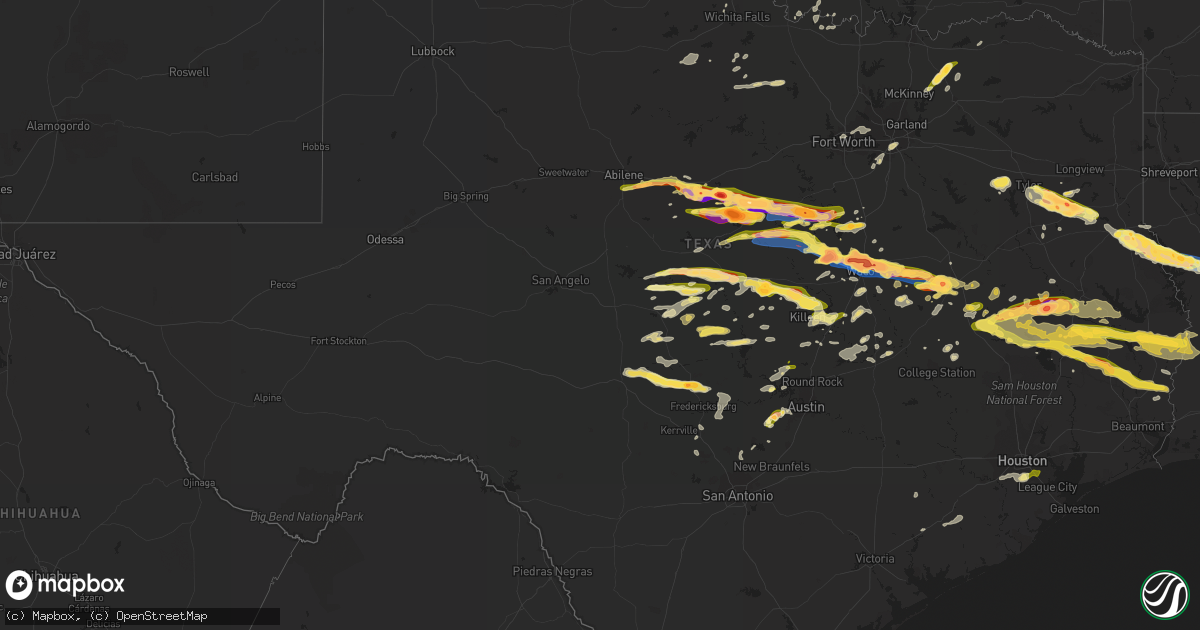
Hail Map in Texas on April 26, 2023
Get this storm
April 26 map
$229
one time, instant access
Download today. No call, no setup
Keep the $229
Bought the map and want the full workflow? Apply the entire $229 to a subscription within 7 days. None of it is wasted.
Every map, not just this one
This buys you this map. Subscription and you get every map we run, in the markets you choose from a few cities to whole states to nationwide. Plus real-time alerts the moment a storm fires.
Contact data
Name, contact info, occupancy, even credit band for addresses in the footprint. You go from where it hit to who to call.
Become the source they trust
Unlimited branding weather history reports on demand. You already have the documented answer ready for the property owner, and you are the one who showed up with it.
Property data and RoofTrace estimates
Pull up any address you have got, its value and the exact code rules for that jurisdiction, straight from One Click Code. Then RoofTrace estimates the squares, pitch, and roof value, priced the way you price.
Storm reports in Texas
Texas
| Date | Description |
|---|---|
| 04/26/20236:47 PM CDT | Reported via social media. |
| 04/26/20236:45 PM CDT | Quarter size hail reported just south of the huxley area via social media. |
| 04/26/20236:44 PM CDT | Ham radio report of ping pong ball-sized hail in mart. |
| 04/26/20236:28 PM CDT | Hail up to half dollar size near the campti community in shelby county. |
| 04/26/20236:27 PM CDT | Hail up to quarter size reported in the shelbyville community. |
| 04/26/20236:23 PM CDT | Tennis ball sized hail in walnut springs. |
| 04/26/20236:22 PM CDT | Trained spotter reports baseball-sized hail in hallsburg. |
| 04/26/20236:20 PM CDT | Corrects previous tstm wnd dmg report from 6 ne center. Hail reported northeast of center near the james community. |
| 04/26/20236:20 PM CDT | Hail reported northeast of center near the james community. |
| 04/26/20236:17 PM CDT | 4.5 inch diameter hail 2 miles east of waco. |
| 04/26/20236:14 PM CDT | Baseball-sized hail measured in walnut springs. |
| 04/26/20236:11 PM CDT | Trained spotter reports large amounts of quarter-sized hail just north of walnut springs. |
| 04/26/20236:06 PM CDT | Ham radio report of golf ball-sized hail at the baylor campus. |
| 04/26/20235:56 PM CDT | Ping pong sized hail reported at mcclennan community college main campus. |
| 04/26/20235:50 PM CDT | Widespread powerlines and trees down in the timpson area. |
| 04/26/20235:48 PM CDT | Trees and powerlines day southwest of gary city around the area of fm road 999 and county roads 178... 179... And 180. Damage also extends south into northern shelby co |
| 04/26/20235:47 PM CDT | Softball sized hail bosqueville to near waco regional airport. |
| 04/26/20235:44 PM CDT | Ping pong ball sized hail between whitney and hillsboro. |
| 04/26/20235:39 PM CDT | Softball sized hail in de leon. |
| 04/26/20235:39 PM CDT | Waco... Tx |
| 04/26/20235:37 PM CDT | Social media video of large amounts of hail up to tennis ball size 4 miles outside of dublin. |
| 04/26/20235:34 PM CDT | Ham radio report of quarter-sized hail near bosqueville on the north side of waco. |
| 04/26/20235:29 PM CDT | Baseball sized hail in de leon. |
| 04/26/20235:29 PM CDT | Amateur radio spotter reported quarter sized hail 2 miles south of whitney. |
| 04/26/20235:26 PM CDT | Twitter video evidence of a brief... Small tornado in this area. No damage found or reported. |
| 04/26/20235:25 PM CDT | A local report indicates 1.00 inch wind near 1 SW INDIAN CREEK |
| 04/26/20235:18 PM CDT | Social media video of tennis to baseball sized hail falling south of stephenville. |
| 04/26/20235:16 PM CDT | Quarter sized hail in stephenville. |
| 04/26/20235:13 PM CDT | Large amounts of baseball sized hail... Possibly larger... Reported just east-southeast of valley mills by trained spotter.om along hwy 41 near the border of levy and alachua |
| 04/26/20235:13 PM CDT | Large amounts of baseball sized hail... Possibly larger... Reported just east-southeast of valley mills by trained spotter. |
| 04/26/20235:13 PM CDT | Dublin fire department reporting baseball sized hail in the city of dublin. |
| 04/26/20235:06 PM CDT | Amateur radio spotter reported quarter-sized hail in china springs. |
| 04/26/20235:05 PM CDT | Several reports of windshields and skylights broken... Along with damaged traffic signals and power outages. Hail over 2 inches reported across the city. |
| 04/26/20235:05 PM CDT | Corrects previous hail report from henderson. Several reports of windshields and skylights broken... Along with damaged traffic signals and power outages. Hail up to ba |
| 04/26/20235:05 PM CDT | Delayed report - cocorahs spotter reported a large amount of hail that lasted for roughly 20 minutes 0.9 miles ese of valley mills that led to shredded leaves... Car de |
| 04/26/20235:00 PM CDT | Significant hailstorm across the city of henderson. Widespread hail ranging from quarter to golf ball size. |
| 04/26/20234:58 PM CDT | Video evidence of a brief... Small tornado in this area. No damage found or reported. |
| 04/26/20234:57 PM CDT | Trained spotter reported baseball-sized hail 10 miles northeast of de leon. |
| 04/26/20234:56 PM CDT | Quarter size hail reported near intersection of van buren st and hwy 64 in henderson. |
| 04/26/20234:55 PM CDT | Reported on county road 405 d southwest of henderson via social media. |
| 04/26/20234:50 PM CDT | Golf ball sized hail reported on highway 6 and fm 854 west of valley mills. |
| 04/26/20234:50 PM CDT | Quarter size hail in the carlisle price community. |
| 04/26/20234:46 PM CDT | Public measured hail slightly above 2 inches in the turnertown community. |
| 04/26/20234:45 PM CDT | Hail covering the ground from dime size to half dollar size just south of towns of overton and new london along fm road 838. |
| 04/26/20234:42 PM CDT | Golf ball size reported in the selman city community via social media. |
| 04/26/20234:40 PM CDT | Hail up to golfball size reported in the arp area via social media. |
| 04/26/20234:39 PM CDT | *** 1 inj *** sheriff office reports a turned over mobile home on county road 4623 and a tree on a vehicle on county road 4619. Both reports occurred near the henrys ch |
| 04/26/20234:35 PM CDT | Trees and powerlines down in the areas of county roads 2138... 2166 and 2169 in southern smith county near the town of troup. |
| 04/26/20234:32 PM CDT | Social media picture of tennis-ball sized hail near gorman. |
| 04/26/20234:31 PM CDT | Numerous trees and power lines down. |
| 04/26/20234:30 PM CDT | Trained spotter reported 3 inch hail near gorman near highway 6. |
| 04/26/20234:19 PM CDT | Ham spotter in iredell reports nickel to quarter-sized hail. |
| 04/26/20234:16 PM CDT | A local report indicates 2.50 inch wind near 1 W CARBON |
| 04/26/20234:10 PM CDT | A local report indicates 1.00 inch wind near 1 W IREDELL |
| 04/26/20234:02 PM CDT | A local report indicates 1.00 inch wind near 1 S CISCO |
| 04/26/20233:50 PM CDT | A local report indicates 1.00 inch wind near PUTNAM |
| 04/26/20233:29 PM CDT | . |
| 04/26/20233:29 PM CDT | A local report indicates 1.00 inch wind near 5 WNW ADMIRAL |
| 04/26/20233:23 PM CDT | A local report indicates 1.00 inch wind near 3 S BAIRD |
| 04/26/20233:04 PM CDT | A local report indicates 1.75 inch wind near EULA |
| 04/26/20232:55 PM CDT | A local report indicates 1.00 inch wind near 1 WSW POTOSI |
| 04/26/20234:51 AM CDT | Quarter size hail at beamer and beltway 8. |
| 04/26/20233:20 AM CDT | 1 inch size hail reported near ford park. |
| 04/26/202312:39 AM CDT | Social media post of a picture of a weather station screen reporting a wind gust to 76 mph. |
| 04/25/202311:30 PM CDT | Local em reports trees down along fm 1745 n. Some trees were also snapped off at their tops; small tree limbs and tree debris covered the road. |
| 04/25/202311:25 PM CDT | Tyler co. Em reports 1 inch hail across the city of chester. |
| 04/25/202311:20 PM CDT | Reports of 7 homes damaged in the corrigan area due to fallen trees. Downed power lines reported off of us 59n. |
| 04/25/202311:13 PM CDT | Large tree limbs were downed by strong thunderstorm wind gusts in moscow. Nickel sized hail was also observed. |
| 04/25/202311:00 PM CDT | Spotter report of fallen trees and power outage. Pea size hail. |
| 04/25/202310:47 PM CDT | A local report indicates 1.00 inch wind near 3 SSE LIBERTY HILL |
| 04/25/202310:43 PM CDT | A local report indicates 1.00 inch wind near 2 N LIBERTY HILL |
| 04/25/202310:35 PM CDT | Time estimated by radar. |
| 04/25/202310:29 PM CDT | A local report indicates 1.75 inch wind near 14 NE GROVETON |
| 04/25/202310:22 PM CDT | A local report indicates 2.75 inch wind near 9 SE KENNARD |
| 04/25/202310:06 PM CDT | Report received via mping. |
| 04/25/202310:01 PM CDT | Social media picture. |
| 04/25/20239:57 PM CDT | A local report indicates 1.25 inch wind near MIDWAY |
| 04/25/20239:55 PM CDT | A local report indicates 1.00 inch wind near 5 ENE MADISONVILLE |
| 04/25/20239:29 PM CDT | Strong thunderstorm wind gusts resulted in downed trees in a residential area of crockett. Time estimated based on radar. |
| 04/25/20239:15 PM CDT | Delayed report - train spotter reported quarter-sized hail in eastern leon county near cr 112. |
| 04/25/20238:47 PM CDT | Quarter to golf ball sized hail near i-35 at loop 363. |
| 04/25/20238:15 PM CDT | A local report indicates 2.00 inch wind near 7 W JEWETT |
| 04/25/20238:00 PM CDT | A local report indicates 1.75 inch wind near 9 WNW JEWETT |
| 04/25/20237:50 PM CDT | Report of ping pong ball size hail 3.3 miles northeast of dripping springs. Report received via cocorahs. |
| 04/25/20237:50 PM CDT | Golf ball sized hail reported by tv meteorologist. |
| 04/25/20237:43 PM CDT | Golf ball size hail reported on social media. |
| 04/25/20237:34 PM CDT | Kact. |
| 04/25/20237:08 PM CDT | A local report indicates 1.75 inch wind near 5 SSW EVANT |
| 04/25/20237:02 PM CDT | Golf ball sized hail on highway 164 near groesbeck. |
All States Impacted by Hail Map on April 26, 2023
Cities Impacted by Hail Map on April 26, 2023
- Ryan, OK
- Saint Jo, TX
- Seymour, TX
- Holliday, TX
- Nocona, TX
- Windthorst, TX
- Gainesville, TX
- Muenster, TX
- Henrietta, TX
- Ringling, OK
- Burneyville, OK
- Leon, OK
- Iowa Park, TX
- Fort Worth, TX
- Jesup, GA
- Guyton, GA
- Springfield, GA
- Hortense, GA
- Brunswick, GA
- Rincon, GA
- Port Wentworth, GA
- Pooler, GA
- Bloomingdale, GA
- Melbourne, FL
- Palm Bay, FL
- Abilene, TX
- Tuscola, TX
- Folkston, GA
- Jupiter, FL
- Palm Beach Gardens, FL
- Malabar, FL
- Clyde, TX
- Baird, TX
- Debary, FL
- Sanford, FL
- Hilliard, FL
- Savannah, GA
- Richmond Hill, GA
- Cuthbert, GA
- Shellman, GA
- West Palm Beach, FL
- North Palm Beach, FL
- Grant, FL
- Sebastian, FL
- Melbourne Beach, FL
- Callahan, FL
- Dawson, GA
- Ben Wheeler, TX
- Chandler, TX
- Brownsboro, TX
- Vero Beach, FL
- Cisco, TX
- Rising Star, TX
- Bryceville, FL
- Carbon, TX
- Eastland, TX
- Hico, TX
- Iredell, TX
- Oviedo, FL
- Tyler, TX
- Christmas, FL
- Orlando, FL
- Gorman, TX
- Arp, TX
- Jacksonville, FL
- Troup, TX
- Overton, TX
- Valley Mills, TX
- Ranger, TX
- De Leon, TX
- Desdemona, TX
- Henderson, TX
- Selman City, TX
- Price, TX
- Middleburg, FL
- Starke, FL
- Dublin, TX
- Stephenville, TX
- Fort Pierce, FL
- Port Saint Lucie, FL
- Jensen Beach, FL
- Stuart, FL
- Hobe Sound, FL
- Comanche, TX
- Rockwood, TX
- Santa Anna, TX
- Brookesmith, TX
- Lohn, TX
- Laneville, TX
- Meridian, TX
- Morgan, TX
- China Spring, TX
- Waco, TX
- Whitney, TX
- Hillsboro, TX
- Long Branch, TX
- Mount Enterprise, TX
- Carthage, TX
- Rochelle, TX
- Brownwood, TX
- Mullin, TX
- Gustine, TX
- Walnut Springs, TX
- Bluff Dale, TX
- Lake Butler, FL
- Keystone Heights, FL
- Brooker, FL
- Carlton, TX
- Elm Mott, TX
- Crawford, TX
- Timpson, TX
- Tenaha, TX
- Woodway, TX
- Ocala, FL
- Hamilton, TX
- Center, TX
- Glen Rose, TX
- Riesel, TX
- Goldthwaite, TX
- Gouldbusk, TX
- Laurel Hill, FL
- Loving, TX
- Albany, GA
- Murchison, TX
- Kilgore, TX
- Gatesville, TX
- Andalusia, AL
- Fort Stewart, GA
- Haltom City, TX
- Whitehouse, TX
- Paisley, FL
- Deland, FL
- Eustis, FL
- Grapevine, TX
- North Richland Hills, TX
- Colleyville, TX
- Euless, TX
- Bedford, TX
- Dallas, TX
- Hurst, TX
- Saint Cloud, FL
- Richland Springs, TX
- Mart, TX
- Axtell, TX
- Kopperl, TX
- Cranfills Gap, TX
- Shelbyville, TX
- Jonesboro, TX
- Clifton, TX
- Silver Springs, FL
- Blum, TX
- Cleburne, TX
- Joaquin, TX
- Archer, FL
- Converse, LA
- Noble, LA
- Williston, FL
- Groesbeck, TX
- Hampton, FL
- Gainesville, FL
- San Saba, TX
- Prairie Hill, TX
- Polk City, FL
- Bushnell, FL
- Zwolle, LA
- Covington, TX
- Webster, FL
- Groveland, FL
- Thornton, TX
- Fort McCoy, FL
- Anthony, FL
- Citra, FL
- Reddick, FL
- Micanopy, FL
- Evant, TX
- Lampasas, TX
- Lake Alfred, FL
- Davenport, FL
- Haines City, FL
- Lometa, TX
- Mexia, TX
- Many, LA
- Winter Haven, FL
- Copperas Cove, TX
- Wimberley, TX
- Dripping Springs, TX
- Driftwood, TX
- Austin, TX
- Cherokee, TX
- Jewett, TX
- Marquez, TX
- Buffalo, TX
- Donie, TX
- Dundee, FL
- Lake Hamilton, FL
- Belmont, LA
- Robeline, LA
- Lake Wales, FL
- Fort Hood, TX
- Babson Park, FL
- Frostproof, FL
- Killeen, TX
- Harker Heights, TX
- Nolanville, TX
- Belton, TX
- Temple, TX
- Mansfield, LA
- Centerville, TX
- Midway, TX
- Lovelady, TX
- Crockett, TX
- Mason, TX
- Junction, TX
- Madisonville, TX
- Harper, TX
- Doss, TX
- Groveton, TX
- Pennington, TX
- Kennard, TX
- Apple Springs, TX
- Trinity, TX
- Huntsville, TX
- Fredericksburg, TX
- Lufkin, TX
- Oakhurst, TX
- Farmersville, TX
- Blue Ridge, TX
- Leonard, TX
- Celeste, TX
- Bonham, TX
- Bailey, TX
- Wolfe City, TX
- Ladonia, TX
- Onalaska, TX
- Livingston, TX
- Diboll, TX
- Liberty Hill, TX
- Leander, TX
- Georgetown, TX
- Spicewood, TX
- Greenville, TX
- Midway, AL
- Clayton, AL
- Jacksboro, TX
- Lorena, TX
- Bruceville, TX
- Chilton, TX
- Eddy, TX
- Kempner, TX
- Teague, TX
- Fairfield, TX
- Lake City, FL
- Fort White, FL
- Waynesboro, MS
- Banks, AL
- Union Springs, AL
- Cross Plains, TX
- Branford, FL
- Midlothian, TX
- Itasca, TX
- Red Oak, TX
- Cedar Hill, TX
- Desoto, TX
- Duncanville, TX
- Brady, TX
- Hext, TX
- Jacksonville, TX
- Wells, TX
- Kosse, TX
- Marlin, TX
- Shubuta, MS
- Newberry, FL
- Cameron, TX
- Luverne, AL
- Glenwood, AL
- Goshen, AL
- Troy, AL
- Brantley, AL
- Franklin, TX
- Live Oak, FL
- Gary, TX
- Reagan, TX
- Bremond, TX
- McGregor, TX
- Abbott, TX
- Aquilla, TX
- Lott, TX
- Troy, TX
- Penelope, TX
- Leona, TX
- West, TX
- Morriston, FL
- Greenville, FL
- Hewitt, TX
- Lawtey, FL
- Raiford, FL
- Star, TX
- Bryson, TX
- Jermyn, TX
- London, TX
- Buckholts, TX
- Salado, TX
- Florence, TX
- Reklaw, TX
- Clewiston, FL
- Saint George, GA
- Brookhaven, MS
- Wesson, MS
- Alachua, FL
- Canyon Lake, TX
- Spring Branch, TX
- Early, TX
- Blanket, TX
- Auburndale, FL
- Waverly, FL
- Dunnellon, FL
- Oxford, FL
- Summerfield, FL
- Mount Calm, TX
- Voca, TX
- Valley Spring, TX
- Pontotoc, TX
- Clermont, FL
- Wildwood, FL
- Green Cove Springs, FL
- Logansport, LA
- Rusk, TX
- Rosebud, TX
- Oglesby, TX
- Jasper, FL
- Oakwood, TX
- Grapeland, TX
- Normangee, TX
- Zephyr, TX
- Woodville, TX
- Warren, TX
- Corrigan, TX
- Chester, TX
- Colmesneil, TX
- Jasper, TX
- Hillister, TX
- Newton, TX
- Fred, TX
- Spurger, TX
- Silsbee, TX
- Buna, TX
- Burkeville, TX
- Call, TX
- Burnet, TX
- Tow, TX
- Bertram, TX
- Llano, TX
- Bluffton, TX
- Bryan, TX
- Round Mountain, TX
- Marble Falls, TX
- Holland, TX
- Iola, TX
- North Zulch, TX
- Honey Grove, TX
- Ville Platte, LA
- Burlington, TX
- Granger, TX
- Thorndale, TX
- Bartlett, TX
- Loxahatchee, FL
- Bulverde, TX
- Milano, TX
- Rockdale, TX
- Gause, TX
- Huntington, TX
- Zavalla, TX
- Moscow, TX
- Stonewall, TX
- San Marcos, TX
- Boerne, TX
- Pipe Creek, TX
- Comfort, TX
- Jarrell, TX
- Bon Wier, TX
- Johnson City, TX
- Willow City, TX
- Deweyville, TX
- Trenton, TX
- Pointblank, TX
- Kirbyville, TX
- Deridder, LA
- Broaddus, TX
- Evans, LA
- Merryville, LA
- Blanco, TX
- The Villages, FL
- Leesville, LA
- Bronson, TX
- Wiergate, TX
- Starks, LA
- Brookeland, TX
- Columbia, MS
- Poplarville, MS
- Lumberton, MS
- Sumrall, MS
- Carriere, MS
- Hattiesburg, MS
- Perkinston, MS
- Wiggins, MS
- Lucedale, MS
- Gautier, MS
- Vancleave, MS
- Moss Point, MS
- Pearland, TX
- Houston, TX
- Pasadena, TX
- South Houston, TX
- Utica, MS
- Ventress, LA
- Jackson, LA
- Plaquemine, LA
- Saint Martinville, LA
- Opelousas, LA
- Evergreen, LA
- Palmetto, LA
- Bunkie, LA
- Morrow, LA
- Plaucheville, LA
- Washington, LA
- Saint Landry, LA
- Bogalusa, LA
- Angie, LA
- Purvis, MS
- Ethel, LA
- Breaux Bridge, LA
- White Castle, LA
- Grosse Tete, LA
- Bush, LA
- McHenry, MS
- Picayune, MS
- Morganza, LA
- Batchelor, LA
- Saint Francisville, LA
- Maringouin, LA
- Ocean Springs, MS
- Garwood, TX
- Wilmer, AL
- Church Point, LA
- Melville, LA
- Sugar Land, TX
- Fresno, TX
- Stafford, TX
- Missouri City, TX
- Arnaudville, LA
- Abita Springs, LA
- Mobile, AL
- Franklinton, LA
- Boling, TX
- Wharton, TX
- El Campo, TX
- Maurepas, LA
- Semmes, AL
- Ganado, TX
- Louise, TX
- Seminary, MS
- Ellisville, MS
- Soso, MS


