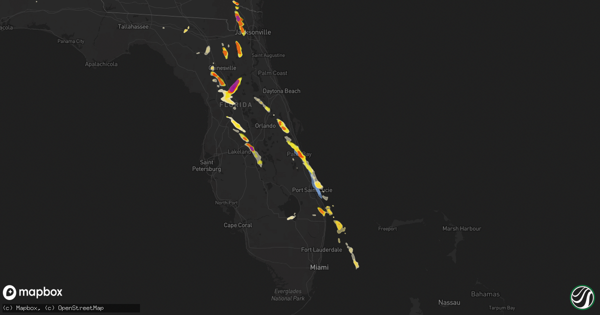
Hail Map on April 26, 2023
Get this storm
April 26 map
$229
one time, instant access
Download today. No call, no setup
Keep the $229
Bought the map and want the full workflow? Apply the entire $229 to a subscription within 7 days. None of it is wasted.
Every map, not just this one
This buys you this map. Subscription and you get every map we run, in the markets you choose from a few cities to whole states to nationwide. Plus real-time alerts the moment a storm fires.
Contact data
Name, contact info, occupancy, even credit band for addresses in the footprint. You go from where it hit to who to call.
Become the source they trust
Unlimited branding weather history reports on demand. You already have the documented answer ready for the property owner, and you are the one who showed up with it.
Property data and RoofTrace estimates
Pull up any address you have got, its value and the exact code rules for that jurisdiction, straight from One Click Code. Then RoofTrace estimates the squares, pitch, and roof value, priced the way you price.
Storm reports
Mississippi
| Date | Description |
|---|---|
| 04/26/20236:43 AM CDT | Public reports golf ball sized hail in wade... Ms in jackson county. |
| 04/26/20236:37 AM CDT | Called circle e farms and owner reports lots of golf ball hail fell. |
| 04/26/20236:31 AM CDT | Report on social media of 2 inch hail |
| 04/26/20236:29 AM CDT | Siding damage from wind driven hail in wade. Relayed via social media. |
| 04/26/20236:28 AM CDT | More damaged siding and windows from win blown hail. Hail was as at least large as golf ball but possibly larger. |
| 04/26/20236:27 AM CDT | Public reports golf ball sized hail in hurley... Ms in jackson county... Ms. |
| 04/26/20236:12 AM CDT | Call shop rite grocery on river rd in lucedale... Ms and store employee reports hail up to quarter size falling. |
| 04/26/20236:01 AM CDT | Called ramsey springs general store who reports lots of hail falling sizes ranging from nickel to quarter size. |
| 04/26/20235:33 AM CDT | Social media report with pictures of quarter hail in perkinston... Ms. |
| 04/26/20235:12 AM CDT | Skywarn spotter reports quarter hail roughly 6 miles se of poplarville in stone county... Ms. |
| 04/26/20235:12 AM CDT | Social media report with pictures of busted windows on broome school rd in george county ms. |
| 04/26/20235:12 AM CDT | Separate skywarn spotter reported golf ball hail just west of perkinston... Ms. |
| 04/26/20235:12 AM CDT | Skywarn spotter reports quarter hail roughly |
| 04/26/20234:50 AM CDT | Ham report relayed via nws mob of quarter size hail southeast of poplarville. |
| 04/26/20234:37 AM CDT | Report of trees down at savannah-millard rd and hwy 53 in pearl river county... Ms. |
| 04/26/20234:36 AM CDT | Hail up to quarter size briefly... Followed by lots of pea sized. Some reports of minor roof damage in the area. |
| 04/26/20233:59 AM CDT | Quarter size hail on pine burr rd. |
| 04/26/20233:42 AM CDT | Quarter hail in the clear creek community. |
Louisiana
| Date | Description |
|---|---|
| 04/26/20236:55 PM CDT | Public reports of hail up to baseball size near noble and converse near highway 191 along toledo bend. Also... Photos of damaged vehicle from hail near baseball size. |
| 04/25/20237:34 PM CDT | Hail covering the ground completely in the belmont area... With hail up to half dollar size. Also... Hail completely covering state hwy 175 between belmont and many. |
| 04/25/20237:20 PM CDT | Hail reported via social media up to ping pong size... Completely covering the ground northeast of zwolle. |
| 04/25/20237:18 PM CDT | Hail up to quarter size reported via social media in zwolle. |
| 04/25/20237:13 PM CDT | Hail completely covering the ground in noble up to half dollar size. |
| 04/25/20237:07 PM CDT | Hail covering the ground from dime to quarter size in converse. Report via ktbs social media. |
| 04/25/20237:05 PM CDT | Quarter size hail reported between the towns of noble and converse. |
Georgia
| Date | Description |
|---|---|
| 04/26/20233:48 PM CDT | Quarter sized hail reported east of shellman. |
| 04/26/20233:20 PM CDT | Public reported tennis ball size hail in richmond hill. |
| 04/26/20233:14 PM CDT | Pictures relayed via social media of multiple trees down along timber trail. Time estimated from radar. |
| 04/26/20233:10 PM CDT | A resident in the 70 block of gentry way reported golf ball sized hail. |
| 04/26/20233:05 PM CDT | Social media report of golf ball size hail along i-95 between exits 94 and 90. Time estimated from radar. |
| 04/26/20232:52 PM CDT | Relayed via social media. |
| 04/26/20232:31 PM CDT | Multiple hail sizes...largest estimated to be golf ball size. |
| 04/26/20232:20 PM CDT | Spotter reporting pea to quarter size hail on wyndham way. |
| 04/26/20232:15 PM CDT | Photos provided through social media. Mt. Pleasant rd near post rd. In wayne county... Ga time est. By radar. |
| 04/26/20232:10 PM CDT | Spotter reported quarter size hail along jimmy deloach pkwy at morgan lakes industrial blvd. |
| 04/26/20231:55 PM CDT | Received report of golf ball size along hwy 341 in wayne county about 2 miles w/nw of post road. Stated hail caused corner of vehicle windshield to crack. |
| 04/26/20231:55 PM CDT | Local broadcast media relayed a picture of a hail stone a little smaller than a golf ball which occurred near the intersection of hw-30 and midland road. |
| 04/26/20231:50 PM CDT | Amateur radio operator reporting quarter to half dollar size hail off shearouse rd. |
| 04/26/20231:30 PM CDT | Corrects previous hail report from 1 n gardi. Relayed via social media. Time estimated by radar. Hail within the gardi... Ga area. |
| 04/26/20231:21 PM CDT | Mping report of quarter size hail. |
| 04/26/20231:16 PM CDT | 911 call center reported multiple trees down in downtown guyton. Roads impacted included 4th street... 5th street... And 6th street. |
| 04/26/20231:11 PM CDT | 911 call center reported a tree down along highway 17 at keith road. Time estimated from radar. |
Texas
| Date | Description |
|---|---|
| 04/26/20236:47 PM CDT | Reported via social media. |
| 04/26/20236:45 PM CDT | Quarter size hail reported just south of the huxley area via social media. |
| 04/26/20236:44 PM CDT | Ham radio report of ping pong ball-sized hail in mart. |
| 04/26/20236:28 PM CDT | Hail up to half dollar size near the campti community in shelby county. |
| 04/26/20236:27 PM CDT | Hail up to quarter size reported in the shelbyville community. |
| 04/26/20236:23 PM CDT | Tennis ball sized hail in walnut springs. |
| 04/26/20236:22 PM CDT | Trained spotter reports baseball-sized hail in hallsburg. |
| 04/26/20236:20 PM CDT | Hail reported northeast of center near the james community. |
| 04/26/20236:20 PM CDT | Corrects previous tstm wnd dmg report from 6 ne center. Hail reported northeast of center near the james community. |
| 04/26/20236:17 PM CDT | 4.5 inch diameter hail 2 miles east of waco. |
| 04/26/20236:14 PM CDT | Baseball-sized hail measured in walnut springs. |
| 04/26/20236:11 PM CDT | Trained spotter reports large amounts of quarter-sized hail just north of walnut springs. |
| 04/26/20236:06 PM CDT | Ham radio report of golf ball-sized hail at the baylor campus. |
| 04/26/20235:56 PM CDT | Ping pong sized hail reported at mcclennan community college main campus. |
| 04/26/20235:50 PM CDT | Widespread powerlines and trees down in the timpson area. |
| 04/26/20235:48 PM CDT | Trees and powerlines day southwest of gary city around the area of fm road 999 and county roads 178... 179... And 180. Damage also extends south into northern shelby co |
| 04/26/20235:47 PM CDT | Softball sized hail bosqueville to near waco regional airport. |
| 04/26/20235:44 PM CDT | Ping pong ball sized hail between whitney and hillsboro. |
| 04/26/20235:39 PM CDT | Softball sized hail in de leon. |
| 04/26/20235:39 PM CDT | Waco... Tx |
| 04/26/20235:37 PM CDT | Social media video of large amounts of hail up to tennis ball size 4 miles outside of dublin. |
| 04/26/20235:34 PM CDT | Ham radio report of quarter-sized hail near bosqueville on the north side of waco. |
| 04/26/20235:29 PM CDT | Amateur radio spotter reported quarter sized hail 2 miles south of whitney. |
| 04/26/20235:29 PM CDT | Baseball sized hail in de leon. |
| 04/26/20235:26 PM CDT | Twitter video evidence of a brief... Small tornado in this area. No damage found or reported. |
| 04/26/20235:25 PM CDT | A local report indicates 1.00 inch wind near 1 SW INDIAN CREEK |
| 04/26/20235:18 PM CDT | Social media video of tennis to baseball sized hail falling south of stephenville. |
| 04/26/20235:16 PM CDT | Quarter sized hail in stephenville. |
| 04/26/20235:13 PM CDT | Large amounts of baseball sized hail... Possibly larger... Reported just east-southeast of valley mills by trained spotter.om along hwy 41 near the border of levy and alachua |
| 04/26/20235:13 PM CDT | Dublin fire department reporting baseball sized hail in the city of dublin. |
| 04/26/20235:13 PM CDT | Large amounts of baseball sized hail... Possibly larger... Reported just east-southeast of valley mills by trained spotter. |
| 04/26/20235:06 PM CDT | Amateur radio spotter reported quarter-sized hail in china springs. |
| 04/26/20235:05 PM CDT | Delayed report - cocorahs spotter reported a large amount of hail that lasted for roughly 20 minutes 0.9 miles ese of valley mills that led to shredded leaves... Car de |
| 04/26/20235:05 PM CDT | Corrects previous hail report from henderson. Several reports of windshields and skylights broken... Along with damaged traffic signals and power outages. Hail up to ba |
| 04/26/20235:05 PM CDT | Several reports of windshields and skylights broken... Along with damaged traffic signals and power outages. Hail over 2 inches reported across the city. |
| 04/26/20235:00 PM CDT | Significant hailstorm across the city of henderson. Widespread hail ranging from quarter to golf ball size. |
| 04/26/20234:58 PM CDT | Video evidence of a brief... Small tornado in this area. No damage found or reported. |
| 04/26/20234:57 PM CDT | Trained spotter reported baseball-sized hail 10 miles northeast of de leon. |
| 04/26/20234:56 PM CDT | Quarter size hail reported near intersection of van buren st and hwy 64 in henderson. |
| 04/26/20234:55 PM CDT | Reported on county road 405 d southwest of henderson via social media. |
| 04/26/20234:50 PM CDT | Golf ball sized hail reported on highway 6 and fm 854 west of valley mills. |
| 04/26/20234:50 PM CDT | Quarter size hail in the carlisle price community. |
| 04/26/20234:46 PM CDT | Public measured hail slightly above 2 inches in the turnertown community. |
| 04/26/20234:45 PM CDT | Hail covering the ground from dime size to half dollar size just south of towns of overton and new london along fm road 838. |
| 04/26/20234:42 PM CDT | Golf ball size reported in the selman city community via social media. |
| 04/26/20234:40 PM CDT | Hail up to golfball size reported in the arp area via social media. |
| 04/26/20234:39 PM CDT | *** 1 inj *** sheriff office reports a turned over mobile home on county road 4623 and a tree on a vehicle on county road 4619. Both reports occurred near the henrys ch |
| 04/26/20234:35 PM CDT | Trees and powerlines down in the areas of county roads 2138... 2166 and 2169 in southern smith county near the town of troup. |
| 04/26/20234:32 PM CDT | Social media picture of tennis-ball sized hail near gorman. |
| 04/26/20234:31 PM CDT | Numerous trees and power lines down. |
| 04/26/20234:30 PM CDT | Trained spotter reported 3 inch hail near gorman near highway 6. |
| 04/26/20234:19 PM CDT | Ham spotter in iredell reports nickel to quarter-sized hail. |
| 04/26/20234:16 PM CDT | A local report indicates 2.50 inch wind near 1 W CARBON |
| 04/26/20234:10 PM CDT | A local report indicates 1.00 inch wind near 1 W IREDELL |
| 04/26/20234:02 PM CDT | A local report indicates 1.00 inch wind near 1 S CISCO |
| 04/26/20233:50 PM CDT | A local report indicates 1.00 inch wind near PUTNAM |
| 04/26/20233:29 PM CDT | . |
| 04/26/20233:29 PM CDT | A local report indicates 1.00 inch wind near 5 WNW ADMIRAL |
| 04/26/20233:23 PM CDT | A local report indicates 1.00 inch wind near 3 S BAIRD |
| 04/26/20233:04 PM CDT | A local report indicates 1.75 inch wind near EULA |
| 04/26/20232:55 PM CDT | A local report indicates 1.00 inch wind near 1 WSW POTOSI |
| 04/26/20234:51 AM CDT | Quarter size hail at beamer and beltway 8. |
| 04/26/20233:20 AM CDT | 1 inch size hail reported near ford park. |
| 04/26/202312:39 AM CDT | Social media post of a picture of a weather station screen reporting a wind gust to 76 mph. |
| 04/25/202311:30 PM CDT | Local em reports trees down along fm 1745 n. Some trees were also snapped off at their tops; small tree limbs and tree debris covered the road. |
| 04/25/202311:25 PM CDT | Tyler co. Em reports 1 inch hail across the city of chester. |
| 04/25/202311:20 PM CDT | Reports of 7 homes damaged in the corrigan area due to fallen trees. Downed power lines reported off of us 59n. |
| 04/25/202311:13 PM CDT | Large tree limbs were downed by strong thunderstorm wind gusts in moscow. Nickel sized hail was also observed. |
| 04/25/202311:00 PM CDT | Spotter report of fallen trees and power outage. Pea size hail. |
| 04/25/202310:47 PM CDT | A local report indicates 1.00 inch wind near 3 SSE LIBERTY HILL |
| 04/25/202310:43 PM CDT | A local report indicates 1.00 inch wind near 2 N LIBERTY HILL |
| 04/25/202310:35 PM CDT | Time estimated by radar. |
| 04/25/202310:29 PM CDT | A local report indicates 1.75 inch wind near 14 NE GROVETON |
| 04/25/202310:22 PM CDT | A local report indicates 2.75 inch wind near 9 SE KENNARD |
| 04/25/202310:06 PM CDT | Report received via mping. |
| 04/25/202310:01 PM CDT | Social media picture. |
| 04/25/20239:57 PM CDT | A local report indicates 1.25 inch wind near MIDWAY |
| 04/25/20239:55 PM CDT | A local report indicates 1.00 inch wind near 5 ENE MADISONVILLE |
| 04/25/20239:29 PM CDT | Strong thunderstorm wind gusts resulted in downed trees in a residential area of crockett. Time estimated based on radar. |
| 04/25/20239:15 PM CDT | Delayed report - train spotter reported quarter-sized hail in eastern leon county near cr 112. |
| 04/25/20238:47 PM CDT | Quarter to golf ball sized hail near i-35 at loop 363. |
| 04/25/20238:15 PM CDT | A local report indicates 2.00 inch wind near 7 W JEWETT |
| 04/25/20238:00 PM CDT | A local report indicates 1.75 inch wind near 9 WNW JEWETT |
| 04/25/20237:50 PM CDT | Report of ping pong ball size hail 3.3 miles northeast of dripping springs. Report received via cocorahs. |
| 04/25/20237:50 PM CDT | Golf ball sized hail reported by tv meteorologist. |
| 04/25/20237:43 PM CDT | Golf ball size hail reported on social media. |
| 04/25/20237:34 PM CDT | Kact. |
| 04/25/20237:08 PM CDT | A local report indicates 1.75 inch wind near 5 SSW EVANT |
| 04/25/20237:02 PM CDT | Golf ball sized hail on highway 164 near groesbeck. |
Florida
| Date | Description |
|---|---|
| 04/26/20236:50 PM CDT | Corrects previous hail report from anthony. Photos of large hail relayed via social media. Largest hailstone was between 2.5 to 3 inches when laid next to measuring tap |
| 04/26/20236:50 PM CDT | Photos of large hail relayed via social media. Largest hailstone was between 2 and 2.25 inches when laid next to measuring tape. |
| 04/26/20236:50 PM CDT | Levy county public safety officer reported golf ball size hail along hwy 41 at the alachua and levy county border. Photo of measured hailstone relayed via social media. |
| 04/26/20236:50 PM CDT | Levy county emergency management submitted picture of approximately golf ball sized hail from along hwy 41 near the border of levy and alachua counties. |
| 04/26/20236:47 PM CDT | Ping pong size hail reported near archer. Hail has covered the yard. Hail appears to progressively getting bigger. |
| 04/26/20236:35 PM CDT | A local report indicates 1.25 inch wind near 2 W OCALA |
| 04/26/20236:30 PM CDT | Marion county emergency management reports that approximately 50 vehicles were damaged by hail at the public safety complex. Time of hail damage based on radar data. |
| 04/26/20236:30 PM CDT | Em reported golf ball size hail fell at marion county eoc. |
| 04/26/20236:25 PM CDT | Corrects previous hail report from archer. Levy county public safety officer in archer called in lots of hail was falling. He estimated it to be quarter size hail. |
| 04/26/20236:25 PM CDT | Levy county fireman in archer called in lots of hail was falling. He estimated it to be quarter size hail. |
| 04/26/20236:15 PM CDT | Skywarn spotter reported 1 inch diameter hail falling in the area around sw 68th court in ocala fl. |
| 04/26/20235:33 PM CDT | Delayed report... A marine thunderstorm wind gust of 59 mph / 51 knots was recorded by the wxflow mesonet station xjup located at juno beach pier. |
| 04/26/20235:20 PM CDT | Trained spotter relayed report of golf ball size hail falling at camp blanding near starke... Fl. |
| 04/26/20234:55 PM CDT | Reported 1 inch hail falling near intersection of cr 215 and n. Deer rd in middleburg... Fl. |
| 04/26/20234:40 PM CDT | Hail melted too quickly to get accurate sizes. |
| 04/26/20234:34 PM CDT | Trained spotter reports tree branches down across roads and damage to street signs in christmas. |
| 04/26/20234:31 PM CDT | Weatherflow station xstl measured a wind gust of 69kt/79mph from the north-northwest. |
| 04/26/20234:26 PM CDT | Trained spotter reports hail around 1 inch near the intersection of fort christmas rd and wheeler rd. |
| 04/26/20234:07 PM CDT | Tree fell onto a home in fort pierce... Causing damage. No injuries reported. |
| 04/26/20234:00 PM CDT | Photo of hail relayed via social media. Time estimated by radar. |
| 04/26/20234:00 PM CDT | Photo of hail relayed via social media. Time estimated by radar. |
| 04/26/20233:42 PM CDT | The asos at the vero beach regional airport |
| 04/26/20233:25 PM CDT | Multiple photos relayed of large hail estimated around golf ball size. |
| 04/26/20233:20 PM CDT | Large tree snapped at trunk. Photo relayed via social media. Damage took place near hilliard. |
| 04/26/20233:15 PM CDT | Photo report taken of golf ball sized hail in palm beach gardens. |
| 04/26/20233:12 PM CDT | Report from mping: half dollar |
| 04/26/20233:12 PM CDT | Report from mping: half dollar . |
| 04/26/20232:49 PM CDT | Delayed report. Trained spotter reports hail at least one inch in diameter in west melbourne near the intersection of eber and hollywood. |
| 04/26/20232:45 PM CDT | Delayed report. Cocorahs observer reported hail up to one and three quarter inches in diameter... Causing shredded leaves and car dents... Near the intersection of wald |
| 04/26/20232:45 PM CDT | Delayed report. Trained spotter reports hail up to one inch in diameter near the intersection of gates st sw and harlow ave. |
| 04/26/20232:45 PM CDT | Brevard county emergency manager reports roof damage; partial blown off and/or partial collapse at baer's furniture store on 4260 new haven/hwy 192. Reports of water en |
| 04/26/20232:43 PM CDT | Delayed report. Trained spotter reports one inch hail near malabar rd... Between eldron blvd and and emerson dr... For the last three to four minutes. |
| 04/26/20232:43 PM CDT | Delayed report. Trained spotter reports quarter sized hail northbound on interstate 95 near the palm bay rd exit. |
| 04/26/20232:42 PM CDT | Delayed report. Received report of hail up to quarter sized near the intersection of s babcock st and palm bay rd. |
| 04/26/20232:42 PM CDT | Received several reports and pictures of hail up to golf ball size and substantial vegetation damage due to hail in the west melbourne area around 3:40 pm. Time estimat |
| 04/26/20232:40 PM CDT | Trained spotter reports quarter sized hail near west melbourne. |
| 04/26/20232:40 PM CDT | Spotter reports damage to cars and roofs in palm bay with golf ball sized hail observed. Rome ave and nebraska ave |
| 04/26/20232:39 PM CDT | Trained spotter reports half dollar sized hail near the interstate 95 and palm bay rd ne interchange. |
| 04/26/20232:26 PM CDT | Off duty nws employee estimates wind gusts to 60mph/52kts with tree branches down near the intersection of conestee dr and potomac dr. |
| 04/26/20232:26 PM CDT | Off duty nws employee reports half dollar sized hail near the intersection of conestee dr and potomac dr. |
| 04/26/20232:23 PM CDT | Extensive damage reported in mobile home community with many structures roofs lost and a carport and shed destroyed. Multiple trees and powerlines down. |
| 04/26/20232:23 PM CDT | Delayed report. A weather station in the lamp lighter village measured a wind gust of 62kt/71mph from the north-northwest. |
| 04/26/20232:22 PM CDT | Delayed report. A power company repair crew reported damage to homes in the groveland mobil home park community near the w eau gallie blvd and interstate 95 interchange |
| 04/26/20232:22 PM CDT | Dime to penny size hail falling at nws melbourne. Began at 322 pm. Quarter size hail at 337 pm. |
| 04/25/20238:15 PM CDT | Quarter size hail report in lake wales area via ham radio and trained spotter. |
| 04/25/20238:00 PM CDT | Fdem region 3 coordinator reported damage across ocala from passing thunderstorms. Reported a structure fire due to high winds. Reported hail damage to approx. 40 count |
| 04/25/20238:00 PM CDT | Late report: thunderstorm wind damage to 2 car ports near lake starr. |
| 04/25/20237:30 PM CDT | 1-inch hail reported near intersection of u.s. Hwy 27 and lucerne park rd. Time estimated from radar. |
| 04/25/20237:25 PM CDT | Public report received via social media showed video and picture of golf ball sized hail between lake alfred and haines city. |
Alabama
| Date | Description |
|---|---|
| 04/26/20235:35 PM CDT | A few trees blown down at various locations around troy. |
| 04/26/20235:08 PM CDT | Multiple trees blown down in the goshen area. |
| 04/26/20235:05 PM CDT | Multiple trees down in glenwood with one tree on a residence. Numerous power outages across the area. Time estimated by radar. |
| 04/26/20234:56 PM CDT | Emergency manager reports numerous trees down and power lines down around the 3000 block of old brantley luverne rd. Time estimated by radar. |
| 04/26/20234:45 PM CDT | A single tree came down in brantley damaging a residence and downing powerlines on st. James st. |
Cities Impacted by Hail Map on April 26, 2023
- Ryan, OK
- Saint Jo, TX
- Seymour, TX
- Holliday, TX
- Nocona, TX
- Windthorst, TX
- Gainesville, TX
- Muenster, TX
- Henrietta, TX
- Ringling, OK
- Burneyville, OK
- Leon, OK
- Iowa Park, TX
- Fort Worth, TX
- Jesup, GA
- Guyton, GA
- Springfield, GA
- Hortense, GA
- Brunswick, GA
- Rincon, GA
- Port Wentworth, GA
- Pooler, GA
- Bloomingdale, GA
- Melbourne, FL
- Palm Bay, FL
- Abilene, TX
- Tuscola, TX
- Folkston, GA
- Jupiter, FL
- Palm Beach Gardens, FL
- Malabar, FL
- Clyde, TX
- Baird, TX
- Debary, FL
- Sanford, FL
- Hilliard, FL
- Savannah, GA
- Richmond Hill, GA
- Cuthbert, GA
- Shellman, GA
- West Palm Beach, FL
- North Palm Beach, FL
- Grant, FL
- Sebastian, FL
- Melbourne Beach, FL
- Callahan, FL
- Dawson, GA
- Ben Wheeler, TX
- Chandler, TX
- Brownsboro, TX
- Vero Beach, FL
- Cisco, TX
- Rising Star, TX
- Bryceville, FL
- Carbon, TX
- Eastland, TX
- Hico, TX
- Iredell, TX
- Oviedo, FL
- Tyler, TX
- Christmas, FL
- Orlando, FL
- Gorman, TX
- Arp, TX
- Jacksonville, FL
- Troup, TX
- Overton, TX
- Valley Mills, TX
- Ranger, TX
- De Leon, TX
- Desdemona, TX
- Henderson, TX
- Selman City, TX
- Price, TX
- Middleburg, FL
- Starke, FL
- Dublin, TX
- Stephenville, TX
- Fort Pierce, FL
- Port Saint Lucie, FL
- Jensen Beach, FL
- Stuart, FL
- Hobe Sound, FL
- Comanche, TX
- Rockwood, TX
- Santa Anna, TX
- Brookesmith, TX
- Lohn, TX
- Laneville, TX
- Meridian, TX
- Morgan, TX
- China Spring, TX
- Waco, TX
- Whitney, TX
- Hillsboro, TX
- Long Branch, TX
- Mount Enterprise, TX
- Carthage, TX
- Rochelle, TX
- Brownwood, TX
- Mullin, TX
- Gustine, TX
- Walnut Springs, TX
- Bluff Dale, TX
- Lake Butler, FL
- Keystone Heights, FL
- Brooker, FL
- Carlton, TX
- Elm Mott, TX
- Crawford, TX
- Timpson, TX
- Tenaha, TX
- Woodway, TX
- Ocala, FL
- Hamilton, TX
- Center, TX
- Glen Rose, TX
- Riesel, TX
- Goldthwaite, TX
- Gouldbusk, TX
- Laurel Hill, FL
- Loving, TX
- Albany, GA
- Murchison, TX
- Kilgore, TX
- Gatesville, TX
- Andalusia, AL
- Fort Stewart, GA
- Haltom City, TX
- Whitehouse, TX
- Paisley, FL
- Deland, FL
- Eustis, FL
- Grapevine, TX
- North Richland Hills, TX
- Colleyville, TX
- Euless, TX
- Bedford, TX
- Dallas, TX
- Hurst, TX
- Saint Cloud, FL
- Richland Springs, TX
- Mart, TX
- Axtell, TX
- Kopperl, TX
- Cranfills Gap, TX
- Shelbyville, TX
- Jonesboro, TX
- Clifton, TX
- Silver Springs, FL
- Blum, TX
- Cleburne, TX
- Joaquin, TX
- Archer, FL
- Converse, LA
- Noble, LA
- Williston, FL
- Groesbeck, TX
- Hampton, FL
- Gainesville, FL
- San Saba, TX
- Prairie Hill, TX
- Polk City, FL
- Bushnell, FL
- Zwolle, LA
- Covington, TX
- Webster, FL
- Groveland, FL
- Thornton, TX
- Fort McCoy, FL
- Anthony, FL
- Citra, FL
- Reddick, FL
- Micanopy, FL
- Evant, TX
- Lampasas, TX
- Lake Alfred, FL
- Davenport, FL
- Haines City, FL
- Lometa, TX
- Mexia, TX
- Many, LA
- Winter Haven, FL
- Copperas Cove, TX
- Wimberley, TX
- Dripping Springs, TX
- Driftwood, TX
- Austin, TX
- Cherokee, TX
- Jewett, TX
- Marquez, TX
- Buffalo, TX
- Donie, TX
- Dundee, FL
- Lake Hamilton, FL
- Belmont, LA
- Robeline, LA
- Lake Wales, FL
- Fort Hood, TX
- Babson Park, FL
- Frostproof, FL
- Killeen, TX
- Harker Heights, TX
- Nolanville, TX
- Belton, TX
- Temple, TX
- Mansfield, LA
- Centerville, TX
- Midway, TX
- Lovelady, TX
- Crockett, TX
- Mason, TX
- Junction, TX
- Madisonville, TX
- Harper, TX
- Doss, TX
- Groveton, TX
- Pennington, TX
- Kennard, TX
- Apple Springs, TX
- Trinity, TX
- Huntsville, TX
- Fredericksburg, TX
- Lufkin, TX
- Oakhurst, TX
- Farmersville, TX
- Blue Ridge, TX
- Leonard, TX
- Celeste, TX
- Bonham, TX
- Bailey, TX
- Wolfe City, TX
- Ladonia, TX
- Onalaska, TX
- Livingston, TX
- Diboll, TX
- Liberty Hill, TX
- Leander, TX
- Georgetown, TX
- Spicewood, TX
- Greenville, TX
- Midway, AL
- Clayton, AL
- Jacksboro, TX
- Lorena, TX
- Bruceville, TX
- Chilton, TX
- Eddy, TX
- Kempner, TX
- Teague, TX
- Fairfield, TX
- Lake City, FL
- Fort White, FL
- Waynesboro, MS
- Banks, AL
- Union Springs, AL
- Cross Plains, TX
- Branford, FL
- Midlothian, TX
- Itasca, TX
- Red Oak, TX
- Cedar Hill, TX
- Desoto, TX
- Duncanville, TX
- Brady, TX
- Hext, TX
- Jacksonville, TX
- Wells, TX
- Kosse, TX
- Marlin, TX
- Shubuta, MS
- Newberry, FL
- Cameron, TX
- Luverne, AL
- Glenwood, AL
- Goshen, AL
- Troy, AL
- Brantley, AL
- Franklin, TX
- Live Oak, FL
- Gary, TX
- Reagan, TX
- Bremond, TX
- McGregor, TX
- Abbott, TX
- Aquilla, TX
- Lott, TX
- Troy, TX
- Penelope, TX
- Leona, TX
- West, TX
- Morriston, FL
- Greenville, FL
- Hewitt, TX
- Lawtey, FL
- Raiford, FL
- Star, TX
- Bryson, TX
- Jermyn, TX
- London, TX
- Buckholts, TX
- Salado, TX
- Florence, TX
- Reklaw, TX
- Clewiston, FL
- Saint George, GA
- Brookhaven, MS
- Wesson, MS
- Alachua, FL
- Canyon Lake, TX
- Spring Branch, TX
- Early, TX
- Blanket, TX
- Auburndale, FL
- Waverly, FL
- Dunnellon, FL
- Oxford, FL
- Summerfield, FL
- Mount Calm, TX
- Voca, TX
- Valley Spring, TX
- Pontotoc, TX
- Clermont, FL
- Wildwood, FL
- Green Cove Springs, FL
- Logansport, LA
- Rusk, TX
- Rosebud, TX
- Oglesby, TX
- Jasper, FL
- Oakwood, TX
- Grapeland, TX
- Normangee, TX
- Zephyr, TX
- Woodville, TX
- Warren, TX
- Corrigan, TX
- Chester, TX
- Colmesneil, TX
- Jasper, TX
- Hillister, TX
- Newton, TX
- Fred, TX
- Spurger, TX
- Silsbee, TX
- Buna, TX
- Burkeville, TX
- Call, TX
- Burnet, TX
- Tow, TX
- Bertram, TX
- Llano, TX
- Bluffton, TX
- Bryan, TX
- Round Mountain, TX
- Marble Falls, TX
- Holland, TX
- Iola, TX
- North Zulch, TX
- Honey Grove, TX
- Ville Platte, LA
- Burlington, TX
- Granger, TX
- Thorndale, TX
- Bartlett, TX
- Loxahatchee, FL
- Bulverde, TX
- Milano, TX
- Rockdale, TX
- Gause, TX
- Huntington, TX
- Zavalla, TX
- Moscow, TX
- Stonewall, TX
- San Marcos, TX
- Boerne, TX
- Pipe Creek, TX
- Comfort, TX
- Jarrell, TX
- Bon Wier, TX
- Johnson City, TX
- Willow City, TX
- Deweyville, TX
- Trenton, TX
- Pointblank, TX
- Kirbyville, TX
- Deridder, LA
- Broaddus, TX
- Evans, LA
- Merryville, LA
- Blanco, TX
- The Villages, FL
- Leesville, LA
- Bronson, TX
- Wiergate, TX
- Starks, LA
- Brookeland, TX
- Columbia, MS
- Poplarville, MS
- Lumberton, MS
- Sumrall, MS
- Carriere, MS
- Hattiesburg, MS
- Perkinston, MS
- Wiggins, MS
- Lucedale, MS
- Gautier, MS
- Vancleave, MS
- Moss Point, MS
- Pearland, TX
- Houston, TX
- Pasadena, TX
- South Houston, TX
- Utica, MS
- Ventress, LA
- Jackson, LA
- Plaquemine, LA
- Saint Martinville, LA
- Opelousas, LA
- Evergreen, LA
- Palmetto, LA
- Bunkie, LA
- Morrow, LA
- Plaucheville, LA
- Washington, LA
- Saint Landry, LA
- Bogalusa, LA
- Angie, LA
- Purvis, MS
- Ethel, LA
- Breaux Bridge, LA
- White Castle, LA
- Grosse Tete, LA
- Bush, LA
- McHenry, MS
- Picayune, MS
- Morganza, LA
- Batchelor, LA
- Saint Francisville, LA
- Maringouin, LA
- Ocean Springs, MS
- Garwood, TX
- Wilmer, AL
- Church Point, LA
- Melville, LA
- Sugar Land, TX
- Fresno, TX
- Stafford, TX
- Missouri City, TX
- Arnaudville, LA
- Abita Springs, LA
- Mobile, AL
- Franklinton, LA
- Boling, TX
- Wharton, TX
- El Campo, TX
- Maurepas, LA
- Semmes, AL
- Ganado, TX
- Louise, TX
- Seminary, MS
- Ellisville, MS
- Soso, MS