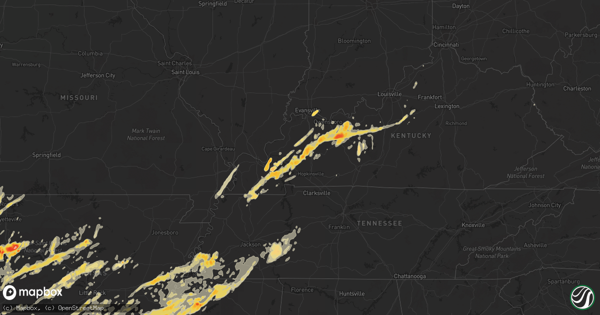
Hail Map in Tennessee on April 26, 2011
Get this storm
April 26 map
$229
one time, instant access
Download today. No call, no setup
Keep the $229
Bought the map and want the full workflow? Apply the entire $229 to a subscription within 7 days. None of it is wasted.
Every map, not just this one
This buys you this map. Subscription and you get every map we run, in the markets you choose from a few cities to whole states to nationwide. Plus real-time alerts the moment a storm fires.
Contact data
Name, contact info, occupancy, even credit band for addresses in the footprint. You go from where it hit to who to call.
Become the source they trust
Unlimited branding weather history reports on demand. You already have the documented answer ready for the property owner, and you are the one who showed up with it.
Property data and RoofTrace estimates
Pull up any address you have got, its value and the exact code rules for that jurisdiction, straight from One Click Code. Then RoofTrace estimates the squares, pitch, and roof value, priced the way you price.
Storm reports in Tennessee
Tennessee
| Date | Description |
|---|---|
| 04/26/20116:45 PM CDT | A tree was down greater than 12 inches in diameter. |
| 04/26/20116:35 PM CDT | A local report indicates 1.50 inch wind near DRUMMONDS |
| 04/26/20116:28 PM CDT | A local report indicates 1.75 inch wind near ARLINGTON |
| 04/26/20116:26 PM CDT | A local report indicates 1.50 inch wind near TIPTON |
| 04/26/20116:24 PM CDT | A local report indicates 1.00 inch wind near 5 NW MILLINGTON |
| 04/26/20116:21 PM CDT | Pea to half dollar size hail |
| 04/26/20116:20 PM CDT | Quarter hail reported at airline and wilson rd |
| 04/26/20116:03 PM CDT | Quarter size hail reported by public in downtown bartlett |
| 04/26/20113:25 PM CDT | 3 miles east of dukedom along the ky/tn border |
| 04/26/20117:17 AM CDT | Memphis international airport reported 58 mph gust. |
| 04/26/20116:50 AM CDT | An ef1 tornado with maximum winds 105 to 110 mph affected areas between viola and morrison in warren county around 650 am. Damage began northwest of viola on highway 28 |
| 04/26/20116:49 AM CDT | Numerous trees reportedly blown down. Trained spotter also reported wind gusts estimated at 60 mph. |
| 04/26/20116:48 AM CDT | Trees reported blown down. |
| 04/26/20116:46 AM CDT | Numerous trees were blown down. Damage concentrated near viola in the southwest part of the county. |
| 04/26/20116:45 AM CDT | *** 4 inj *** one trailer destroyed at intersection of wheeler road and five-mile road |
| 04/26/20116:45 AM CDT | An ef0 tornado with maximum winds 70 to 80 mph briefly touched down around 645 am in northeast coffee county. Damage was noted along swan and rock roads. The damage pat |
| 04/26/20116:31 AM CDT | Spotter estimated a 70 mph wind gust. |
| 04/26/20116:30 AM CDT | House off foundation oak hall subdivison. |
| 04/26/20116:30 AM CDT | Trees down along both rock road and new hope road off of highway 55 in summitville area. |
| 04/26/20116:20 AM CDT | Trees were blown down. A spotter measured an 82 mph gust before his home wind equipment was destroyed. |
| 04/26/20116:18 AM CDT | Heavy damage to power poles and lines. |
| 04/26/20116:18 AM CDT | Trained spotter reports a tree down near alexandria. |
| 04/26/20116:16 AM CDT | Trees down on middleton and bluebird roads. |
| 04/26/20116:15 AM CDT | An ef1 tornado with maximum winds 90 to 100 mph touched down around 615 am in extreme southeast bedford county. Damage was centered along magnolia lane and winding way |
| 04/26/20116:08 AM CDT | Trees and powerlines down. |
| 04/26/20116:07 AM CDT | Several trailers overturned with numerous trees down along highway 41a. Church roof blown off near carr creek road and motlow college road. Possible tornado. Time estim |
| 04/26/20116:05 AM CDT | A tree was blown down on a house on lois ridge road. |
| 04/26/20116:05 AM CDT | Large tree down on kingwood drive. Large limbs and lines down as well. |
| 04/26/20116:00 AM CDT | Homes damaged and trees blown down in the bethpage area. |
| 04/26/20115:58 AM CDT | Over one hundred trees down in trotter lane in murfreesboro. Roads partially blocked. Minimum to medium roof damage to homes and outbuildings destroyed. |
| 04/26/20115:57 AM CDT | Regent wood area. Trees down. Powerpole damage. Roof damage. Possible tornado. |
| 04/26/20115:57 AM CDT | Trees were blown down. Spotter measured 74 mph wind with home weather station. |
| 04/26/20115:57 AM CDT | Damage in the jamison place subdivision. Shingles off homes...trees topped and fences blown down |
| 04/26/20115:56 AM CDT | Roof damage and siding damage to houses near haynes drive...possible tornado |
| 04/26/20115:55 AM CDT | Mobile home damage. Possible tornado damage. |
| 04/26/20115:54 AM CDT | Several trees down on st. Andrews drive |
| 04/26/20115:50 AM CDT | Survey team reports an ef0 tornado in the country park subdivision just west of murfreesboro. |
| 04/26/20115:45 AM CDT | Trees down near christiana on caro road and rock springs midland road. Possible tornado. |
| 04/26/20115:45 AM CDT | Survey team reports an ef0 tornado near the community of rockvale. |
| 04/26/20115:45 AM CDT | Trees and powerlines down. |
| 04/26/20115:45 AM CDT | Trees and power lines down mainly in unionville area. |
| 04/26/20115:40 AM CDT | An ef1 tornado with maximum winds 90 to 100 mph touched down around 530 am in northeast marshall county. Damage began just west of the intersection of hwy 31a and thick |
| 04/26/20115:30 AM CDT | Boxwell. Roof off main dining hall. Possible tornado. |
| 04/26/20115:30 AM CDT | On moore road and caldwell in summertown a house destroyed and numerous houses with damage including trees as much as 3 ft in diameter on them. |
| 04/26/20115:30 AM CDT | An ef1 tornado with maximum winds 90 to 100 mph touched down around 530 am in northeast marshall county. Damage began just west of the intersection of hwy 31a and thick |
| 04/26/20115:24 AM CDT | Tree on a house on william and earl road near mt. Pleasant. Other trees were blown down countywide. |
| 04/26/20115:12 AM CDT | Sixty two mile an hour wind gust reported by a trained spotter in mount pleasant. |
| 04/26/20115:12 AM CDT | Bna asos measured 58 mph wind gust. Altimeter spiked from 29.49 inches to 29.62. |
| 04/26/20115:06 AM CDT | Survey team reports an ef1 tornado near summertown near the intersection of graham and moore roads. |
| 04/26/20114:50 AM CDT | Numerous trees were blown down. Poles and power lines were blown down. |
| 04/26/20114:30 AM CDT | Trees and power lines were reported downed across southern portions of the county. |
| 04/26/20113:21 AM CDT | A local report indicates 1.75 inch wind near RICEVILLE |
| 04/26/20112:00 AM CDT | Trees were reported down on highway 281 and highway 13 south. |
| 04/25/201110:57 PM CDT | Trained spotter rpts hail of one inch diameter. |
| 04/25/201110:50 PM CDT | Trained spotter rpts structural damage and trees down in linden. |
| 04/25/20119:30 PM CDT | Power lines down and flooding on highway 205 south and raleigh lagrange road. |
| 04/25/20119:20 PM CDT | A local report indicates 2.00 inch wind near 10 SE LEXINGTON |
| 04/25/20119:20 PM CDT | A local report indicates 60 MPH wind near 10 SE LEXINGTON |
| 04/25/20119:15 PM CDT | A local report indicates 1.00 inch wind near ATOKA |
| 04/25/20119:09 PM CDT | Quarter sized hail with winds to 50 mph. |
| 04/25/20119:04 PM CDT | Possible tornado in trailer park in jacks creek. |
| 04/25/20118:27 PM CDT | Trees were knocked down and a home suffered roof damage on hill house road near highway 138 near toone. Possible tornado. |
All States Impacted by Hail Map on April 26, 2011
Cities Impacted by Hail Map on April 26, 2011
- Clay, KY
- Dixon, KY
- Sebree, KY
- Nebo, KY
- Providence, KY
- Calhoun, KY
- Slaughters, KY
- Princeton, KY
- Moro, AR
- Atoka, OK
- Port Matilda, PA
- Julian, PA
- Nortonville, KY
- Madisonville, KY
- Frenchville, PA
- Havana, AR
- Converse, LA
- Millersburg, PA
- Hegins, PA
- Halifax, PA
- Herndon, PA
- Dornsife, PA
- Gratz, PA
- Spring Glen, PA
- Sacramento, PA
- Dalmatia, PA
- Elizabethville, PA
- Lykens, PA
- Klingerstown, PA
- Berrysburg, PA
- Mccurtain, OK
- Bokoshe, OK
- Pinconning, MI
- Bentonville, AR
- Gentry, AR
- Hiwasse, AR
- Siloam Springs, AR
- Bella Vista, AR
- Gravette, AR
- Decatur, AR
- Centerton, AR
- Garfield, AR
- Lowell, AR
- Rogers, AR
- Valliant, OK
- Gladys, VA
- Long Island, VA
- Scotland Neck, NC
- Rolling Prairie, IN
- La Porte, IN
- Sheridan, AR
- England, AR
- Redfield, AR
- Keo, AR
- Little Rock, AR
- Hensley, AR
- Scott, AR
- New Iberia, LA
- Abbeville, LA
- Erath, LA
- Franklin, LA
- Hamilton, MI
- Wyoming, MI
- Byron Center, MI
- Holland, MI
- Hudsonville, MI
- Zeeland, MI
- Grandville, MI
- Dorr, MI
- Marianna, AR
- Rattan, OK
- Nashoba, OK
- Almyra, AR
- Ethel, AR
- Chidester, AR
- Clarksdale, MS
- Pine Bluff, AR
- Queen City, TX
- Bluff City, AR
- Gurdon, AR
- Garland City, AR
- Fulton, AR
- Carthage, AR
- Lyon, MS
- Warren, AR
- West Helena, AR
- Willisville, AR
- Saint Charles, AR
- Waldo, AR
- De Witt, AR
- Sledge, MS
- Stuttgart, AR
- Lewisville, AR
- Hope, AR
- Bloomburg, TX
- Yorktown, AR
- Altheimer, AR
- Holly Grove, AR
- Hampton, AR
- Star City, AR
- Arkadelphia, AR
- Lexa, AR
- Rison, AR
- Grapevine, AR
- Texarkana, TX
- Dumas, AR
- Helena, AR
- Kingsland, AR
- Tichnor, AR
- Leola, AR
- Friars Point, MS
- Fouke, AR
- Buckner, AR
- Mellwood, AR
- Texarkana, AR
- Fordyce, AR
- Rosston, AR
- Stamps, AR
- Prescott, AR
- Sparkman, AR
- Gillett, AR
- Grady, AR
- Tunica, MS
- Dundee, MS
- Marvell, AR
- Crumrod, AR
- White Hall, AR
- Alligator, MS
- Ivan, AR
- Emmet, AR
- New Edinburg, AR
- Coahoma, MS
- Doddridge, AR
- Gould, AR
- Elaine, AR
- Stephens, AR
- Thornton, AR
- Camden, AR
- Atlanta, TX
- Bearden, AR
- Wilmar, AR
- Ruston, LA
- Holland Patent, NY
- Rome, NY
- Barneveld, NY
- Prospect, NY
- Cold Brook, NY
- Stittville, NY
- Remsen, NY
- Brooksville, MS
- Benton, KY
- Mer Rouge, LA
- Collinston, LA
- Oak Ridge, LA
- Ozark, AR
- Ashland, MS
- Judsonia, AR
- Kensett, AR
- Gladstone, VA
- White Oak, GA
- Kaplan, LA
- Caneyville, KY
- Roundhill, KY
- Brownsville, KY
- Tyrone, PA
- Grand Rapids, MI
- Lisbon, LA
- Lamar, IN
- Grandview, IN
- Gordo, AL
- Cushing, TX
- Mount Enterprise, TX
- Belding, MI
- Bakers Mills, NY
- Sheridan, IN
- Poteau, OK
- Cameron, OK
- Greenville, TX
- White Plains, KY
- Hughes, AR
- Franklin, TX
- Van Buren, AR
- Almond, NY
- Bolivar, NY
- Scio, NY
- Alfred Station, NY
- Wellsville, NY
- Belmont, NY
- Shinglehouse, PA
- Alma, NY
- Andover, NY
- Bolivar, TN
- Center, TX
- Ralston, PA
- Roaring Branch, PA
- Trout Run, PA
- Lowell, MI
- Oologah, OK
- Hulbert, OK
- Fort Gibson, OK
- Tahlequah, OK
- Waldron, AR
- Mansfield, AR
- Winnsboro, LA
- Goldonna, LA
- Linden, TN
- Decaturville, TN
- Arthur City, TX
- Boswell, OK
- Sumner, TX
- Hugo, OK
- Memphis, TN
- Tatum, TX
- Henderson, TX
- Overton, TX
- Kilgore, TX
- Hallsville, TX
- Beckville, TX
- Longview, TX
- Groesbeck, TX
- Marks, MS
- Maud, TX
- Waterford, MS
- Falkner, MS
- Byhalia, MS
- Potts Camp, MS
- Crenshaw, MS
- Sardis, MS
- Naples, TX
- Selmer, TN
- Wabbaseka, AR
- Walnut, MS
- Humphrey, AR
- Snow Lake, AR
- Red Banks, MS
- Douglassville, TX
- Marietta, TX
- Linden, TX
- Omaha, TX
- Hughes Springs, TX
- Michigan City, MS
- Batesville, MS
- Hornsby, TN
- Daingerfield, TX
- Senatobia, MS
- Sarah, MS
- Coldwater, MS
- Como, MS
- Holly Springs, MS
- Lamar, MS
- Middleton, TN
- Sherrill, AR
- Elgin, SC
- Alexander, NY
- Corfu, NY
- Borger, TX
- Panhandle, TX
- Sulphur Springs, TX
- Mountainburg, AR
- Barling, AR
- Alma, AR
- Mulberry, AR
- Keota, OK
- Arkoma, OK
- Cedarville, AR
- Gans, OK
- Charleston, AR
- Cecil, AR
- Uniontown, AR
- Fort Smith, AR
- Rudy, AR
- Spiro, OK
- Pocola, OK
- Muldrow, OK
- Lavaca, AR
- Roland, OK
- Dyer, AR
- Hosston, LA
- Ida, LA
- Crockett, TX
- Sylvan Beach, NY
- Blossvale, NY
- Durhamville, NY
- Canastota, NY
- Verona Beach, NY
- Verona, NY
- Midlothian, TX
- Venus, TX
- Hartford, KY
- Grandview, TX
- Covington, TX
- Rio Vista, TX
- Louisville, MS
- Macon, MS
- Bellwood, PA
- Cresson, PA
- Loretto, PA
- South Fork, PA
- Gallitzin, PA
- Wilmore, PA
- Sidman, PA
- Ashville, PA
- Tipton, PA
- Lilly, PA
- Mineral Point, PA
- Johnstown, PA
- Duncansville, PA
- Dysart, PA
- Portage, PA
- Summerhill, PA
- Altoona, PA
- Elkins, WV
- Glady, WV
- Bowden, WV
- Plainview, AR
- Sterlington, LA
- Monroe, LA
- Stigler, OK
- Moscow, TN
- Williston, TN
- Rossville, TN
- Bolivar, PA
- New Florence, PA
- Portland, MI
- Ionia, MI
- Lake Odessa, MI
- De Queen, AR
- Bradley, AR
- Fairland, OK
- Grove, OK
- Afton, OK
- Booneville, AR
- London, AR
- Cleveland, AR
- Atkins, AR
- Delaware, AR
- Blue Mountain, AR
- Paris, AR
- New Blaine, AR
- Dover, AR
- Hector, AR
- Jerusalem, AR
- Magazine, AR
- Dardanelle, AR
- Belleville, AR
- Scotland, AR
- Russellville, AR
- Clarksville, PA
- Rices Landing, PA
- Apple Springs, TX
- Groveton, TX
- Lovelady, TX
- Pennington, TX
- Kennard, TX
- Corrigan, TX
- Trinity, TX
- North Garden, VA
- Charlottesville, VA
- Goodwell, OK
- Keyes, OK
- Reagan, TN
- Bath Springs, TN
- Lexington, TN
- Saltillo, TN
- Scotts Hill, TN
- Sardis, TN
- Livermore, KY
- Island, KY
- Rumsey, KY
- Sacramento, KY
- Bigelow, AR
- Conway, AR
- Houston, AR
- Plumerville, AR
- Cameron, TX
- Rockdale, TX
- Milano, TX
- Gause, TX
- Hearne, TX
- Lindale, TX
- Widener, AR
- Cordova, TN
- Wheatley, AR
- Proctor, AR
- Forrest City, AR
- West Memphis, AR
- Drummonds, TN
- Heth, AR
- Brighton, TN
- Crawfordsville, AR
- Goodwin, AR
- Atoka, TN
- Millington, TN
- Arlington, TN
- Palestine, AR
- Mason, TN
- Covington, TN
- Colt, AR
- Eads, TN
- Clarendon, AR
- Munford, TN
- Madison, AR
- Earle, AR
- Brinkley, AR
- Marion, AR
- Dukedom, TN
- Dresden, TN
- Water Valley, KY
- Martin, TN
- Sedalia, KY
- Wingo, KY
- South Fulton, TN
- Fulton, KY
- Mayfield, KY
- Cooper, TX
- Donaldson, AR
- Malvern, AR
- Mount Vernon, AR
- Greenbrier, AR
- Vilonia, AR
- Enola, AR
- Romance, AR
- Oak Grove, LA
- Pioneer, LA
- Addison, NY
- Cave Springs, AR
- Summers, AR
- Springdale, AR
- Eureka Springs, AR
- Fayetteville, AR
- Lincoln, AR
- Humnoke, AR
- Rohwer, AR
- Dermott, AR
- McGehee, AR
- Ferdinand, IN
- Huntingburg, IN
- Saint Anthony, IN
- Plain Dealing, LA
- Karnack, TX
- Tennyson, IN
- Dale, IN
- Stendal, IN
- Holland, IN
- Beech Creek, PA
- Pottersdale, PA
- Renovo, PA
- Karthaus, PA
- Westport, PA
- Delhi, LA
- Rayville, LA
- Epps, LA
- Shreveport, LA
- Cameron, WV
- Hindsville, AR
- Ferris, TX
- Lancaster, TX
- Caledonia, MI
- Cayuga, NY
- Auburn, NY
- Union Springs, NY
- Philpot, KY
- Eastview, KY
- Big Clifty, KY
- Dundee, KY
- Mortons Gap, KY
- Glendale, KY
- Calvert City, KY
- Reynolds Station, KY
- Utica, KY
- Manitou, KY
- Crofton, KY
- Hawesville, KY
- Leitchfield, KY
- McHenry, KY
- Gilbertsville, KY
- Eddyville, KY
- Fordsville, KY
- Cloverport, KY
- Falls Of Rough, KY
- Dawson Springs, KY
- Cadiz, KY
- Kirksey, KY
- Centertown, KY
- Union City, TN
- Elizabethtown, KY
- Beaver Dam, KY
- Saint Charles, KY
- Cecilia, KY
- Palmersville, TN
- McDaniels, KY
- Earlington, KY
- Hudson, KY
- Hardin, KY
- Whitesville, KY
- Olaton, KY
- Horse Branch, KY
- Kuttawa, KY
- Adair, OK
- Spavinaw, OK
- Salina, OK
- Pryor, OK
- Strang, OK
- Hillsboro, TX
- Itasca, TX
- New Albany, PA
- Forksville, PA
- Dushore, PA
- Oakwood, TX
- Roxton, TX
- Schuyler, VA
- Faber, VA
- Shipman, VA
- Esmont, VA
- Rusk, TX
- Jacksonville, TX
- Henderson, TN
- Saulsbury, TN
- Tucker, AR
- Finger, TN
- Jefferson, AR
- Duncan, MS
- Monticello, AR
- Hernando, MS
- Bethel Springs, TN
- Fleming, PA
- Warriors Mark, PA
- Bellefonte, PA
- Milesburg, PA
- Ebensburg, PA
- Lock Haven, PA
- Jersey Shore, PA
- Philipsburg, PA
- Mill Hall, PA
- Saint Michael, PA
- Blanchard, PA
- Avis, PA
- Howard, PA
- Guymon, OK
- Hurricane Mills, TN
- Lobelville, TN
- Parkin, AR
- Cumby, TX
- Commerce, TX
- Lake Creek, TX
- Campbell, TX
- Lone Oak, TX
- Paris, TX
- Klondike, TX
- Tuscaloosa, AL
- Timpson, TX
- Henderson, KY
- Reed, KY
- Newburgh, IN
- Spottsville, KY
- Haileyville, OK
- Mcalester, OK
- Hartshorne, OK
- Rolling Fork, MS
- Mayersville, MS
- Buffalo, TX
- Teague, TX
- Fairfield, TX
- Spearsville, LA
- Stonewall, LA
- Gouldsboro, PA
- Moscow, PA
- Hagarville, AR
- Pattonville, TX
- Wolfe City, TX
- Ladonia, TX
- Powderly, TX
- Bagwell, TX
- Honey Grove, TX
- Enloe, TX
- Blossom, TX
- Petty, TX
- Ben Franklin, TX
- Detroit, TX
- Pecan Gap, TX
- Brookston, TX
- Homer, LA
- Italy, TX
- Doddsville, MS
- Clarkton, MO
- Holcomb, MO
- Blackville, SC
- Barnwell, SC
- Aliceville, AL
- Swansea, SC
- Ridgeway, SC
- Camden, SC
- Mineola, TX
- Van, TX
- Tyler, TX
- Memphis, NY
- Elbridge, NY
- Carthage, TX
- Joaquin, TX
- Gary, TX
- Logansport, LA
- Tenaha, TX
- Rockford, MI
- Ada, MI
- Clearfield, PA
- Woodland, PA
- Sinnamahoning, PA
- Morrisdale, PA
- Laceyville, PA
- Meshoppen, PA
- Idabel, OK
- Stanton, MI
- Sidney, MI
- Sheridan, MI
- Fenwick, MI
- Calvert, TX
- Vivian, LA
- Jefferson, TX
- Cleburne, TX
- Melrose, LA
- Natchez, LA
- Natchitoches, LA
- Montgomery, LA
- Tawas City, MI
- Au Gres, MI
- Port Saint Lucie, FL
- Smithland, KY
- Ledbetter, KY
- Symsonia, KY
- Paducah, KY
- Winona, TX
- Elm Grove, LA
- Choudrant, LA
- Coushatta, LA
- Frierson, LA
- Keatchie, LA
- Grand Cane, LA
- Hall Summit, LA
- Columbia, LA
- Chatham, LA
- Bienville, LA
- Eros, LA
- Calhoun, LA
- Simsboro, LA
- Ringgold, LA
- Quitman, LA
- Gloster, LA
- Castor, LA
- Jamestown, LA
- Jonesboro, LA
- Doyline, LA
- Gibsland, LA
- Heflin, LA
- Minden, LA
- Bossier City, LA
- Haughton, LA
- De Berry, TX
- West Monroe, LA
- Keithville, LA
- Mansfield, LA
- French Lick, IN
- Lilesville, NC
- Vestal, NY
- Apalachin, NY
- Endicott, NY
- White Haven, PA
- Hopkins, SC
- Columbia, SC
- Columbiana, AL
- Philadelphia, MS
- Flinton, PA
- Madera, PA
- Irvona, PA
- Glen Hope, PA
- Beccaria, PA
- Patton, PA
- Coalport, PA
- Nacogdoches, TX
- Fort Pierce, FL
- Bardstown, KY
- Prairie Hill, TX
- Ruleville, MS
- Shaw, MS
- Douglass, TX
- Skaneateles, NY
- Talihina, OK
- Wister, OK
- Red Oak, OK
- Caddo Mills, TX
- Farmersville, TX
- Lavon, TX
- Royse City, TX
- Rockwall, TX
- Wylie, TX
- Princeton, TX
- Nevada, TX
- Standish, MI
- Muncy Valley, PA
- Mildred, PA
- Catawissa, PA
- Houtzdale, PA
- Ramey, PA
- Fallentimber, PA
- Smithmill, PA
- Norman, AR
- Mount Ida, AR
- Antlers, OK
- Eutaw, AL
- Nedrow, NY
- Fayetteville, NY
- Marietta, NY
- Bridgeport, NY
- Ava, NY
- Lee Center, NY
- Cleveland, NY
- Syracuse, NY
- Poland, NY
- East Syracuse, NY
- Westernville, NY
- Liverpool, NY
- Manlius, NY
- La Fayette, NY
- Cicero, NY
- Minoa, NY
- Marcellus, NY
- Jamesville, NY
- Kirkville, NY
- Camillus, NY
- Taberg, NY
- Chittenango, NY
- Amherst, VA
- Wright City, OK
- Hooks, TX
- Ashdown, AR
- Blossburg, PA
- Cammal, PA
- North Bend, PA
- Valley Bend, WV
- Franklin, WV
- Seneca Rocks, WV
- Whitmer, WV
- Riverton, WV
- Bartow, WV
- Circleville, WV
- Upper Tract, WV
- Maumelle, AR
- Ringtown, PA
- Shenandoah, PA
- Boston, KY
- Clayton, OK
- New Boston, TX
- Greenville, MI
- Yazoo City, MS
- Mount Calm, TX
- Axtell, TX
- Mexia, TX
- Elm Mott, TX
- West, TX
- Woodway, TX
- Mart, TX
- Coolidge, TX
- Waco, TX
- Leesburg, TX
- Mount Pleasant, TX
- Pittsburg, TX
- Preston, MS
- Ennis, TX
- Waxahachie, TX
- Forreston, TX
- Rice, TX
- Chatfield, TX
- Perryville, AR
- Arrington, VA
- Clinton, AR
- Shirley, AR
- Mabelvale, AR
- Poyen, AR
- Prattsville, AR
- Alexander, AR
- Bauxite, AR
- Benton, AR
- Traskwood, AR
- North Little Rock, AR
- Shongaloo, LA
- Haynesville, LA
- Normangee, TX
- Victor, NY
- Farmington, NY
- Fort Towson, OK
- Spencerville, OK
- Bloomfield, KY
- Richland, MI
- Kalamazoo, MI
- Indian Lake, NY
- Decatur, MI
- Scurry, TX
- Kemp, TX
- Kaufman, TX
- Strongstown, PA
- Northern Cambria, PA
- Seward, PA
- Nanty Glo, PA
- Belsano, PA
- Colver, PA
- Mentcle, PA
- Nicktown, PA
- Heilwood, PA
- Homer City, PA
- Indiana, PA
- Clymer, PA
- Penn Run, PA
- Vintondale, PA
- Cherry Tree, PA
- Mabank, TX
- Crete, IL
- Huntington, AR
- Ralph, AL
- Fairfield Bay, AR
- West Decatur, PA
- New Millport, PA
- Glen Richey, PA
- Olanta, PA
- Ellenboro, WV
- Porters Falls, WV
- Middlebourne, WV
- Proctor, WV
- Waverly, WV
- Petroleum, WV
- Sistersville, WV
- Walker, WV
- Cairo, WV
- Reader, WV
- New Martinsville, WV
- Friendly, WV
- Saint Marys, WV
- Laneville, TX
- Zavalla, TX
- Huntington, TX
- Palmer, TX
- Enfield, IL
- Norris City, IL
- Sallisaw, OK
- Bunch, OK
- Blooming Grove, TX
- Frost, TX
- Barry, TX
- Milford, TX
- De Kalb, MS
- Ochopee, FL
- Corsicana, TX
- Roseland, VA
- Knoxville, AL
- Patrick, SC
- Davilla, TX
- Stilwell, OK
- Tulsa, OK
- Cedar Run, PA
- Texhoma, OK
- Carthage, NC
- Bernice, LA
- Chelsea, OK
- Quinlan, TX
- Plattsburgh, NY
- Derry, PA
- Blairsville, PA
- Quitman, AR
- Bee Branch, AR
- Damascus, AR
- Keene, VA
- Scottsville, VA
- Hazel, KY
- Murray, KY
- Farmington, KY
- Boyle, MS
- Cleveland, MS
- Forney, TX
- Terrell, TX
- Dodson, LA
- Pelsor, AR
- Mena, AR
- Mount Judea, AR
- Subiaco, AR
- Springfield, AR
- Vinita, OK
- Big Cabin, OK
- Owasso, OK
- Talala, OK
- Collinsville, OK
- Claremore, OK
- Donie, TX
- Jewett, TX
- Kosse, TX
- Constantia, NY
- West Monroe, NY
- Finley, OK
- Ringold, OK
- Snow, OK
- Forestport, NY
- Parsons, TN
- Adamsville, TN
- Milledgeville, TN
- Darden, TN
- Enville, TN
- Morris Chapel, TN
- Leslie, AR
- Sand Springs, OK
- East Prairie, MO
- Charleston, MO
- Crystal Springs, MS
- Utica, MS
- Canton, TX
- Ben Wheeler, TX
- Millsboro, PA
- Forbes Road, PA
- East Millsboro, PA
- Brownsville, PA
- Hiller, PA
- Ruffs Dale, PA
- Wickhaven, PA
- Greensburg, PA
- Stockdale, PA
- Dunlevy, PA
- Bovard, PA
- Dawson, PA
- California, PA
- New Stanton, PA
- Fayette City, PA
- Grindstone, PA
- Madison, PA
- Jefferson, PA
- Yukon, PA
- Perryopolis, PA
- Belle Vernon, PA
- Allenport, PA
- Coal Center, PA
- Newell, PA
- Elco, PA
- Daisytown, PA
- Smithton, PA
- Jeannette, PA
- La Belle, PA
- Crabtree, PA
- West Newton, PA
- Roscoe, PA
- Charleroi, PA
- Hunker, PA
- Denbo, PA
- Hannastown, PA
- Wyano, PA
- McRae, AR
- Searcy, AR
- Bald Knob, AR
- Blum, TX
- Whitney, TX
- Louise, MS
- Liberty, PA
- Mineral Springs, PA
- Driftwood, PA
- Cross Fork, PA
- Wellsboro, PA
- Gaines, PA
- Slate Run, PA
- Morris, PA
- Port Clinton, OH
- Lacarne, OH
- Long Lake, NY
- Colton, NY
- Mountain Top, PA
- Wapwallopen, PA
- Wilkes Barre, PA
- Nanticoke, PA
- Pleasant Hill, LA
- Marthaville, LA
- Belmont, LA
- Zwolle, LA
- Many, LA
- Cary, MS
- Lexington, MS
- Arp, TX
- Hawkins, TX
- Alvarado, TX
- Benton, MS
- Kopperl, TX
- Brownsboro, TX
- Mertens, TX
- Camden, MS
- Arcadia, LA
- Maypearl, TX
- Satartia, MS
- Sondheimer, LA
- Mangham, LA
- Kerens, TX
- Dubberly, LA
- Tallulah, LA
- Rosser, TX
- Gladewater, TX
- Bentonia, MS
- Pickens, MS
- Sibley, LA
- Seagoville, TX
- Red Oak, TX
- Transylvania, LA
- Holly Bluff, MS
- Vaughan, MS
- Valley Park, MS
- Eustace, TX
- Tinsley, MS
- Chandler, TX
- Lake Providence, LA
- Jones, LA
- Saline, LA
- Athens, TX
- Canton, MS
- Grand Saline, TX
- Grambling, LA
- Long Branch, TX
- Vicksburg, MS
- Barksdale Afb, LA
- Flora, MS
- Baldwinsville, NY
- Friendsville, PA
- Montrose, PA
- Miami, TX
- Hackett, AR
- Midland, AR
- Memphis, IN
- Borden, IN
- Sellersburg, IN
- West Fork, AR
- Moorefield, WV
- Camden, NY
- Lawton, PA
- San Augustine, TX
- Etoile, TX
- Chireno, TX
- Lufkin, TX
- Hermitage, AR
- Banks, AR
- Avery, TX
- Haworth, OK
- Palestine, TX
- Macedon, NY
- Shortsville, NY
- Boonville, IN
- Cheraw, SC
- Waynesburg, PA
- Holbrook, PA
- Shelbyville, TX
- Waymart, PA
- Lake Ariel, PA
- Owensboro, KY
- Hurt, VA
- Altavista, VA
- Piseco, NY
- Raquette Lake, NY
- Roe, AR
- Grand Rivers, KY
- Pittsburg, OK
- Kiowa, OK
- Jenison, MI
- Colcord, OK
- Glenwood, AR
- Amity, AR
- Caddo Gap, AR
- Kirby, AR
- Marquez, TX
- Centerville, TX
- Lake Village, AR
- Tunkhannock, PA
- Archbold, OH
- Dobson, NC
- Mount Airy, NC
- Locust Grove, OK
- Wynne, AR
- Vandervoort, AR
- Snow Shoe, PA
- Bogata, TX
- Annona, TX
- Clarksville, TX
- Talco, TX
- Osceola Mills, PA
- Cabins, WV
- Petersburg, WV
- Fisher, WV
- Waskom, TX
- Helena, OH
- Ashland, LA
- Cogan Station, PA
- Williamsport, PA
- Montoursville, PA
- Linden, PA
- Wilburton, OK
- Tuskahoma, OK
- Hickman, KY
- New Madrid, MO
- Tiptonville, TN
- Noxapater, MS
- Hartford, AR
- Crawford, MS
- Baker, WV
- Maysville, WV
- Dundee, NY
- Campbell, NY
- Watkins Glen, NY
- Bradford, NY
- Rock Stream, NY
- Painted Post, NY
- Beaver Dams, NY
- Woodbine, GA
- Kingsland, GA
- Blanco, OK
- Eudora, AR
- Benton, PA
- Stillwater, PA
- Shickshinny, PA
- Huntington Mills, PA
- Dowagiac, MI
- Lawton, MI
- Mattawan, MI
- Milton, PA
- Watsontown, PA
- Danville, PA
- Brashear, TX
- Rockingham, NC
- Allendale, SC
- Troup, TX
- Lake Pleasant, NY
- Speculator, NY
- Wells, NY
- Williamstown, PA
- Willisburg, KY
- Danville, VA
- Huron, TN
- Tillar, AR
- Greenwood, AR
- Moshannon, PA
- Wadesboro, NC
- Norwood, NC
- Abbott, TX
- Elkhart, TX
- Dawson, TX
- Malone, TX
- Reagan, TX
- Wortham, TX
- Grapeland, TX
- China Spring, TX
- Crawford, TX
- Valley Mills, TX
- Chilton, TX
- Aquilla, TX
- McGregor, TX
- Hubbard, TX
- Diboll, TX
- Lorena, TX
- Riesel, TX
- Alto, TX
- Hewitt, TX
- Thornton, TX
- Marlin, TX
- Penelope, TX
- Cloutierville, LA
- Robeline, LA
- Georgetown, LA
- Dry Prong, LA
- Winnfield, LA
- Atlanta, LA
- Colfax, LA
- Bullard, TX
- Hastings, PA
- Kingsley, PA
- New Milford, PA
- Rio, WV
- Wardensville, WV
- Mathias, WV
- Harman, WV
- Dryfork, WV
- Davis, WV
- Gretna, VA
- Fremont, OH
- Gibsonburg, OH
- Lindsey, OH
- Elwell, MI
- Riverdale, MI
- Ferriday, LA
- Pelican, LA
- Bynum, TX
- Wisner, LA
- Jena, LA
- Clayton, LA
- Bronson, TX
- Garrison, TX
- Saint Joseph, LA
- Noble, LA
- Bastrop, LA
- Trinidad, TX
- Bryan, TX
- Big Sandy, TX
- Milam, TX
- Pollok, TX
- Shuqualak, MS
- Enterprise, LA
- Marshall, TX
- Newellton, LA
- Whitehouse, TX
- Tullos, LA
- Malakoff, TX
- Kosciusko, MS
- Lorman, MS
- Grayson, LA
- Buckholts, TX
- Benton, LA
- Aimwell, LA
- Wells, TX
- Murchison, TX
- Kelly, LA
- Athens, LA
- Provencal, LA
- Baskin, LA
- Greenwood, LA
- Carthage, MS
- Waterproof, LA
- Chester, TX
- Mooringsport, LA
- Jasper, TX
- Campti, LA
- Powell, TX
- Sicily Island, LA
- Price, TX
- Purdon, TX
- Reklaw, TX
- Jonesville, LA
- Bremond, TX
- Desoto, TX
- Ethel, MS
- Downsville, LA
- Harrisonburg, LA
- Anguilla, MS
- Olla, LA
- Selman City, TX
- Gilbert, LA
- Fort Necessity, LA
- Belcher, LA
- McCool, MS
- Blanchard, LA
- Princeton, LA
- Moody, TX
- Flint, TX
- Redwood, MS
- Cottondale, AL
- Buchanan, MI
- Stinnett, TX
- Spearman, TX
- Hillsgrove, PA
- Poplar Grove, AR
- Grant, OK
- Tupper Lake, NY
- Morgantown, KY
- Mebane, NC
- Burlington, NC
- Solgohachia, AR
- Dennard, AR
- Somerville, TN
- Oakland, TN
- Bee Spring, KY
- Madisonburg, PA
- Hermanville, MS
- Raeford, NC
- Ligonier, PA
- Millwood, KY
- Sweeden, KY
- Arcanum, OH
- Shady Point, OK
- Scranton, AR
- Howe, OK
- Heavener, OK
- Daisy, OK
- Hattieville, AR
- Pottsville, AR
- Center Ridge, AR
- Lamar, AR
- Clarksville, AR
- Genesee, PA
- Ferrum, VA
- Boligee, AL
- Avinger, TX
- Brookeland, TX
- Gillham, AR
- Mahanoy City, PA
- Stratford, TX
- Carlisle, AR
- Troy, PA
- Canton, PA
- Covington, PA
- Mainesburg, PA
- Oakdale, LA
- Glenmora, LA
- Rebuck, PA
- Pillow, PA
- Wiconisco, PA
- Nowata, OK
- Emerson, AR
- New Carlisle, IN
- Galien, MI
- Drums, PA
- Hazleton, PA
- Galatia, IL
- Mountain View, AR
- Fifty Six, AR
- Hazlehurst, MS
- Chicago Heights, IL
- Cotton Valley, LA
- Inlet, NY
- Hanson, KY
- Stella, MO
- Granby, MO
- Lugoff, SC
- Duryea, PA
- Pittston, PA
- Old Forge, PA
- Spring Mills, PA
- Rebersburg, PA
- Crystal, MI
- Vestaburg, MI
- Niles, MI
- Perry, AR
- Adona, AR
- Olive Branch, MS
- Cromwell, KY
- Westview, KY
- Coxs Creek, KY
- New Haven, KY
- Hardinsburg, KY
- Rosine, KY
- Fredonia, KY
- Winthrop, AR
- Dierks, AR
- Horatio, AR
- Eagletown, OK
- Lockesburg, AR
- Broken Bow, OK
- Eucha, OK
- Omer, MI
- Thurmond, NC
- Buhl, AL
- Fosters, AL
- Liberty Hill, SC
- Heath Springs, SC
- Proctor, OK
- Rockport, IN
- Chrisney, IN
- Pineville, MO
- Washburn, MO
- Seligman, MO
- Gilberton, PA
- Bivins, TX
- Rodessa, LA
- Lena, MS
- Forest, MS
- Morton, MS
- Marshall, AR
- Hemphill, TX
- Concord, VA
- Watson, OK
- Alabaster, AL
- Helena, AL
- Pelham, AL
- Brackney, PA
- Scottsburg, VA
- Ulm, AR
- Fountain Hill, AR
- Jersey, AR
- Jordan, NY
- Weedsport, NY
- Wayland, NY
- Naples, NY
- Monroe, VA
- Sallis, MS
- Goodman, MS
- Rose Bud, AR
- Mountain Pine, AR
- Morrilton, AR
- Mayflower, AR
- Jessieville, AR
- Wooster, AR
- Mansfield, PA
- Columbia Cross Roads, PA
- Shunk, PA
- Noel, MO
- Smithfield, KY
- Eminence, KY
- New Castle, KY
- Madison Heights, VA
- Springfield, KY
- Yanceyville, NC
- Medon, TN
- Loganton, PA
- West Finley, PA
- Gruver, TX
- Watson, AR
- Arcadia, OH
- Findlay, OH
- Fostoria, OH
- Sycamore, PA
- Rogersville, PA
- New Freeport, PA
- Whiteville, TN
- Aubrey, AR
- Jacksonville, AR
- Benoit, MS
- Greenville, MS
- Beulah, MS
- Moundville, AL
- Winslow, AR
- Henryville, IN
- Cookville, TX
- Sanford, MI
- Binghamton, NY
- Bloomdale, OH
- Sylvania, GA
- Newington, GA
- Hortense, GA
- Gentryville, IN
- Russellville, KY
- Asheboro, NC
- Hornell, NY
- Watts, OK
- Pinehurst, NC
- Shavertown, PA
- Dallas, PA
- Luzerne, PA
- Wyoming, PA
- Carrolltown, PA
- Commodore, PA
- Twin Rocks, PA
- Armagh, PA
- Robinson, PA
- Alverda, PA
- Hunlock Creek, PA
- Santa Claus, IN
- Midland, MI
- Shepherd, MI
- Beebe, AR
- Port Gibson, MS
- Pattison, MS
- Edgemont, AR
- Higden, AR
- Wardville, OK
- North, SC
- Monroeton, PA
- Collierville, TN
- Honobia, OK
- Shawsville, VA
- Christiansburg, VA
- Elliston, VA
- Winnsboro, TX
- Scroggins, TX
- Montevallo, AL
- Jay, OK
- Avoca, NY
- Prattsburgh, NY
- Bath, NY
- Witts Springs, AR
- Tilly, AR
- Eagles Mere, PA
- Pitkin, LA
- Jesup, GA
- Sperry, OK
- Crandall, TX
- Brickeys, AR
- La Jose, PA
- Westover, PA
- Powell, MO
- Anderson, MO
- Robinsonville, MS
- Lake Cormorant, MS
- Wyalusing, PA
- Conehatta, MS
- Decatur, MS
- Union, MS
- Tobyhanna, PA
- Beverly, WV
- Carrollton, AL
- Springerton, IL
- McLeansboro, IL
- Clifton, TN
- Jacks Creek, TN
- Gowen, MI
- Birdseye, IN
- Darien Center, NY
- Central City, KY
- Rich Square, NC
- Mehoopany, PA
- Keeling, VA
- Blairs, VA
- Starkville, MS
- Celeste, TX
- Hardesty, OK
- Ulmer, SC
- Dubach, LA
- Berrien Springs, MI
- Berrien Center, MI
- Falls, PA
- Clarks Summit, PA
- Garfield, KY
- Harned, KY
- Blanchard, MI
- Edmore, MI
- Calico Rock, AR
- Waynesboro, TN
- Olivehill, TN
- Wickes, AR
- Powderly, KY
- Polkton, NC
- Aaronsburg, PA
- Almo, KY
- Williamstown, NY
- Floyds Knobs, IN
- New Albany, IN
- Paoli, IN
- Lyons, MI
- Bennington, OK
- Celestine, IN
- Jasper, IN
- Rineyville, KY
- Radcliff, KY
- Oark, AR
- Clarence, PA
- Timbo, AR
- Onia, AR
- Russell, AR
- Garvin, OK
- Leland, MS
- Wilburton, PA
- Ashland, PA
- Marion, KY
- Augusta, AR
- Olyphant, PA
- Scranton, PA
- Oswegatchie, NY
- Scipio Center, NY
- Romulus, NY
- Ovid, NY
- Aurora, NY
- Junction City, AR
- Broaddus, TX
- Ozone, AR
- Waxhaw, NC
- Monroe, NC
- Matthews, NC
- Ulster, PA
- East Smithfield, PA
- Milan, PA
- Carmi, IL
- Wayne, WV
- Mahanoy Plane, PA
- Girardville, PA
- Frackville, PA
- Taylorsville, KY
- Portageville, MO
- Warners, NY
- Skaneateles Falls, NY
- Hoffmeister, NY
- Boonville, NY
- Moravia, NY
- Jessup, PA
- Archbald, PA
- Higginson, AR
- Okeechobee, FL
- Evington, VA
- Melbourne, AR
- Hawk Run, PA
- Pennsylvania Furnace, PA
- Spruce Creek, PA
- Davidsville, PA
- Allport, PA
- Windber, PA
- Munson, PA
- Alexandria, PA
- Sherwood, AR
- Farmerville, LA
- Lillie, LA
- Summerfield, LA
- Hallstead, PA
- Waverly, TN
- Sugar Tree, TN
- Savannah, TN
- Sugar Run, PA
- West Baden Springs, IN
- Turbotville, PA
- Pickens, AR
- Toone, TN
- Crocketts Bluff, AR
- Casscoe, AR
- Southaven, MS
- De Valls Bluff, AR
- McNeil, AR
- Walls, MS
- Horn Lake, MS
- Nesbit, MS
- Germantown, TN
- Hickory Valley, TN
- Grand Junction, TN
- La Grange, TN
- Moosic, PA
- Titusville, FL
- Moore Haven, FL
- Laurinburg, NC
- Laurel Hill, NC
- Marston, NC
- Fisherville, KY
- Finchville, KY
- Cub Run, KY
- Clarkson, KY
- Louisa, KY
- Bernhards Bay, NY
- De Kalb, TX
- Thorndale, TX
- Skiatook, OK
- Luxor, PA
- Vestaburg, PA
- Darragh, PA
- Fredericktown, PA
- Latrobe, PA
- Arona, PA
- Herminie, PA
- Youngwood, PA
- New Alexandria, PA
- Greenville, KY
- Bowling Green, KY
- Elkins, AR
- Minter City, MS
- Waterville, PA
- Drumright, OK
- Jennings, OK
- Elizabeth, LA
- Harrison City, PA
- Irwin, PA
- Cohocton, NY
- Branchport, NY
- State College, PA
- Cassandra, PA
- Orviston, PA
- Muskogee, OK
- Dilltown, PA
- Spangler, PA
- Marsteller, PA
- Elmora, PA
- Emeigh, PA
- Saint Boniface, PA
- Saint Benedict, PA
- Grand Ledge, MI
- Lynchburg, VA
- Wickliffe, KY
- Barlow, KY
- Marston, MO
- Gilliam, LA
- Charlotte, MI
- Mulliken, MI
- Palm City, FL
- Indiantown, FL
- Coudersport, PA
- Ghent, KY
- Susquehanna, PA
- Starrucca, PA
- Underwood, IN
- Garland, TX
- Thompson, PA
- Jackson, PA
- Java, VA
- Halifax, NC
- Jackson, NC
- Cove, AR
- Grannis, AR
- Holgate, OH
- Kinta, OK
- West Leyden, NY
- Centre Hall, PA
- Pinebluff, NC
- Aberdeen, NC
- Broughton, IL
- Eldorado, IL
- Raleigh, IL
- Jetson, KY
- Harriet, AR
- Big Flat, AR
- Ratcliff, AR
- Branch, AR
- Pea Ridge, AR
- Duncanville, AL
- Brewerton, NY
- Clay, NY
- Harveys Lake, PA
- Stuart, VA


