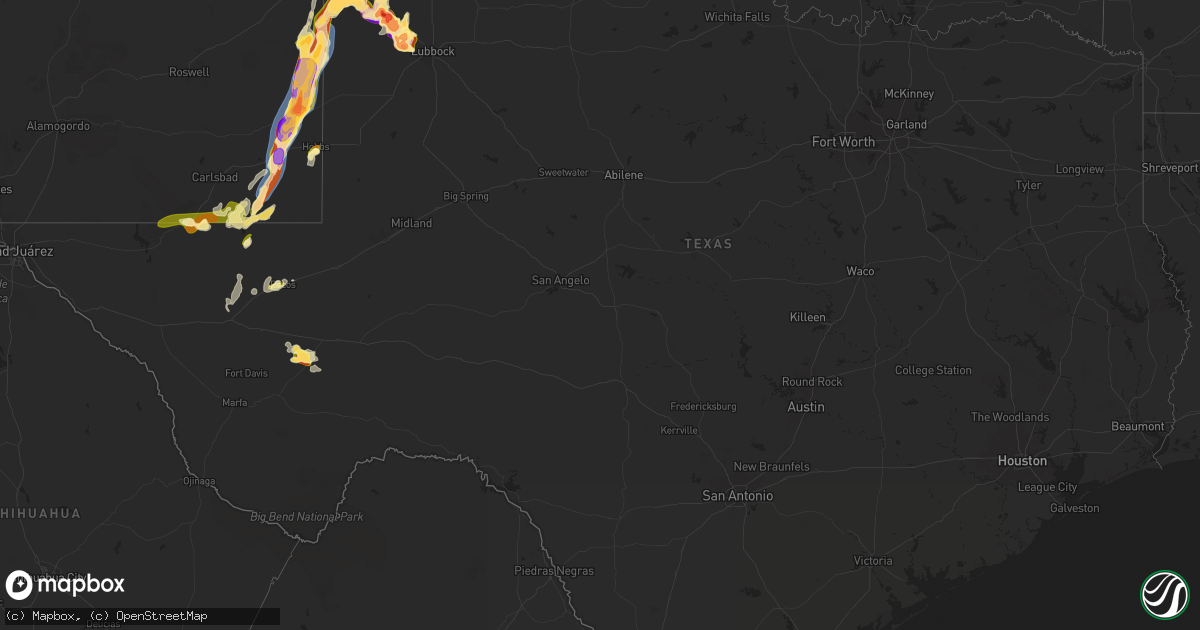
Hail Map in Texas on April 25, 2025
Get this storm
April 25 map
$229
one time, instant access
Download today. No call, no setup
Keep the $229
Bought the map and want the full workflow? Apply the entire $229 to a subscription within 7 days. None of it is wasted.
Every map, not just this one
This buys you this map. Subscription and you get every map we run, in the markets you choose from a few cities to whole states to nationwide. Plus real-time alerts the moment a storm fires.
Contact data
Name, contact info, occupancy, even credit band for addresses in the footprint. You go from where it hit to who to call.
Become the source they trust
Unlimited branding weather history reports on demand. You already have the documented answer ready for the property owner, and you are the one who showed up with it.
Property data and RoofTrace estimates
Pull up any address you have got, its value and the exact code rules for that jurisdiction, straight from One Click Code. Then RoofTrace estimates the squares, pitch, and roof value, priced the way you price.
Storm reports in Texas
Texas
| Date | Description |
|---|---|
| 04/25/20256:49 PM CDT | Report from mping: quarter |
| 04/25/20256:45 PM CDT | Report from mping: golf ball |
| 04/25/20256:41 PM CDT | A local report indicates 1.50 inch wind near 4 NW Shallowater |
| 04/25/20256:38 PM CDT | Report from mping: hen egg |
| 04/25/20256:36 PM CDT | Report from mping: quarter |
| 04/25/20256:30 PM CDT | Coop observer report. |
| 04/25/20256:26 PM CDT | Report from mping: ping pong ball |
| 04/25/20256:02 PM CDT | Report via x. Position estimated. |
| 04/25/20255:59 PM CDT | Picture submitted via social media; a few inches of accumulating hail ranging from nickels to quarters. |
| 04/25/20255:21 PM CDT | Broadcast media report of several golf ball to hen egg sized hailstones along tx highway 214 received via live stream. |
| 04/25/20255:04 PM CDT | Picture submitted via social media; time estimated based on radar. |
| 04/25/20255:03 PM CDT | Lamb county so. |
| 04/25/20254:55 PM CDT | Reports of cyclical tornado by lamb so and spotters. |
| 04/25/20254:41 PM CDT | Bent power pole leaning at least 30 degrees off center. |
| 04/25/20254:40 PM CDT | A local report indicates 65 MPH wind near 5 NE Hovey |
| 04/25/20254:33 PM CDT | Report from mping: quarter |
| 04/25/20254:02 PM CDT | Multiple reports of a large multi-vortex tornado. |
| 04/25/20253:13 PM CDT | Report from mping: tennis ball |
| 04/25/20254:01 AM CDT | A local report indicates 1.00 inch wind near 1 S Hereford |
| 04/25/20253:00 AM CDT | A local report indicates a tornado near 4 W Hart |
| 04/25/20252:35 AM CDT | A local report indicates a tornado near 7 SW Hart |
| 04/25/20251:05 AM CDT | Significant hail damage to vehicles and building roofs from large hail in and around earth. Time is estimated from radar. |
| 04/24/202511:45 PM CDT | A local report indicates 2.00 inch wind near 8 WNW Sudan |
| 04/24/202511:36 PM CDT | Preliminary report; noted debris in church parking lot across the street from the location reported. |
| 04/24/202510:32 PM CDT | Fire fighter dispatch reports a tornado viewing from the intersection of fm 1058 and fm 1057. |
| 04/24/20259:57 PM CDT | West texas mesonet report. |
| 04/24/20259:21 PM CDT | A local report indicates 1.00 inch wind near 7 N Bootleg |
| 04/24/20259:20 PM CDT | Relayed public report. |
| 04/24/20259:10 PM CDT | Delayed report of ping pong to golf ball sized hail. Time estimated from radar. |
| 04/24/20258:20 PM CDT | Damage to houses. Possible wind driven hail. |
| 04/24/20257:50 PM CDT | Quarter size hail reported by pecos fire dept. Time was estimated by radar. |
| 04/24/20257:18 PM CDT | Report from mping: golf ball |
| 04/24/20257:08 PM CDT | Report from mping: baseball |
| 04/24/20257:07 PM CDT | Report from mping: baseball |
| 04/24/20257:04 PM CDT | Report from mping: tennis ball |
| 04/24/20257:02 PM CDT | Former ttu atmo student. |
All States Impacted by Hail Map on April 25, 2025
Cities Impacted by Hail Map on April 25, 2025
- Sicily Island, LA
- Jena, LA
- Clayton, LA
- Ferriday, LA
- Columbia, MS
- Sumrall, MS
- Mccomb, MS
- Tylertown, MS
- Sudan, TX
- Kentwood, LA
- Muleshoe, TX
- Fort Stockton, TX
- Lumberton, MS
- Amherst, TX
- Fieldton, TX
- Angie, LA
- Cleveland, GA
- Vega, TX
- Earth, TX
- Bogalusa, LA
- Masterson, TX
- Poplarville, MS
- Harrisonburg, LA
- Jonesville, LA
- Lula, GA
- Franklinton, LA
- Walker, LA
- Carriere, MS
- Livingston, LA
- Bush, LA
- Cornelia, GA
- Alto, GA
- Enochs, TX
- Amarillo, TX
- Littlefield, TX
- Monterey, LA
- Moreauville, LA
- Roseland, LA
- Mount Airy, GA
- Baldwin, GA
- Pecos, TX
- Angola, LA
- Cottonport, LA
- Mansura, LA
- Friona, TX
- Simmesport, LA
- Como, MS
- Hereford, TX
- Pearl River, LA
- Batchelor, LA
- Gainesville, GA
- Amite, LA
- Sardis, MS
- Toccoa, GA
- Saint Francisville, LA
- Lettsworth, LA
- Eastanollee, GA
- Loranger, LA
- Husser, LA
- Adrian, TX
- Plaucheville, LA
- Anton, TX
- Independence, LA
- Folsom, LA
- Mentone, TX
- Wildorado, TX
- Batesville, MS
- Loving, NM
- Dahlonega, GA
- Clanton, AL
- Jal, NM
- Levelland, TX
- Broadview, NM
- Forest Hill, LA
- Cheneyville, LA
- Palmetto, LA
- Melville, LA
- Robert, LA
- Ponchatoula, LA
- Evergreen, LA
- Courtland, MS
- Grady, NM
- Mcalister, NM
- San Jon, NM
- Morrow, LA
- Shallowater, TX
- Hobbs, NM
- Pope, MS
- Hineston, LA
- Lovington, NM
- House, NM
- La Place, LA
- Oak Ridge, MO
- Millersville, MO
- Ville Platte, LA
- Salt Flat, TX
- Jasper, GA
- Talking Rock, GA
- Marble Hill, MO
- Pitkin, LA
- Enid, MS
- Oakland, MS
- Panhandle, TX
- Lubbock, TX
- Ellijay, GA
- Glenmora, LA
- Jacks Creek, TN
- Clarkesville, GA
- Nashville, KS
- Rolling Meadows, IL
- Green City, MO
- Morse, TX
- Perryton, TX
- Elburn, IL
- Scranton, KS
- Lecompton, KS
- Mount Hope, KS
- South Elgin, IL
- Dumas, TX
- Breckenridge, MO
- Smithville, MO
- Novinger, MO
- Protection, KS
- Wakarusa, KS
- Cunningham, KS
- Plattsburg, MO
- Kirksville, MO
- Lawrence, KS
- Highland Park, IL
- Tonganoxie, KS
- Farmington, IA
- Linneus, MO
- Danville, IA
- Platte City, MO
- Mineral, IL
- Oquawka, IL
- Tecumseh, KS
- Alpha, IL
- Annawan, IL
- Walton, KS
- West Burlington, IA
- Ohio, IL
- Elmdale, KS
- Lynn Center, IL
- Council Grove, KS
- Compton, IL
- Coldwater, KS
- Polo, MO
- Lake City, KS
- Browning, MO
- Oskaloosa, KS
- Wheeling, IL
- Milan, MO
- Lee, IL
- Arlington Heights, IL
- Sun City, KS
- Spearman, TX
- Burrton, KS
- Seaton, IL
- Laverne, OK
- Purdin, MO
- Mooresville, MO
- Perry, KS
- Sawyer, KS
- Dekalb, IL
- Shabbona, IL
- Aledo, IL
- Chula, MO
- Emporia, KS
- Donnellson, IA
- Buffalo, OK
- Cedar Point, KS
- Stinnett, TX
- Pretty Prairie, KS
- Queen City, MO
- Luray, MO
- Greentop, MO
- Schaumburg, IL
- Harveyville, KS
- Walnut, IL
- West Brooklyn, IL
- Maple Park, IL
- Chillicothe, MO
- Lansing, KS
- Newton, KS
- North Newton, KS
- Deerfield, IL
- Downing, MO
- Kingman, KS
- Rosston, OK
- Reading, KS
- Memphis, MO
- Alexis, IL
- Americus, KS
- Woodhull, IL
- Isabel, KS
- Berryton, KS
- Saint Charles, IL
- Paw Paw, IL
- Lathrop, MO
- Haven, KS
- Sperry, IA
- Burlington, IA
- Streamwood, IL
- Atkinson, IL
- Waterman, IL
- Sublette, IL
- Northbrook, IL
- Arbela, MO
- Marion, KS
- Kahoka, MO
- West Point, IA
- North Henderson, IL
- Balko, OK
- Trimble, MO
- Middletown, IA
- Farley, MO
- Booker, TX
- Peabody, KS
- Cambridge, IL
- Allen, KS
- Hoffman Estates, IL
- Palatine, IL
- Little York, IL
- Halstead, KS
- Leavenworth, KS
- Medicine Lodge, KS
- Holt, MO
- Elgin, IL
- Sunray, TX
- Florence, KS
- Sedgwick, KS
- Kansas City, MO
- Green Castle, MO
- Kingston, MO
- McLouth, KS
- Hamilton, MO
- Burlingame, KS
- Amboy, IL
- Strong City, KS
- Steward, IL
- Wheeling, MO
- New Windsor, IL
- Sheffield, IL
- Carbondale, KS
- Wilmore, KS
- Melrose, NM
- Wolf Lake, IL
- Jonesboro, IL
- Reagan, TN
- Tatum, NM
- Mcdonald, NM
- Barstow, TX
- Dawsonville, GA
- Anna, IL
- Moore, ID
- Smyer, TX
- Tucumcari, NM
- Crossroads, NM
- Qulin, MO
- Marble Hill, GA
- Milnesand, NM
- Morton, TX
- Causey, NM
- Rogers, NM
- Cumming, GA
- Ball Ground, GA
- Maple, TX
- Pep, NM
- Texico, NM
- Murrayville, GA
- Clovis, NM
- Bovina, TX
- Dimmitt, TX
- Westminster, SC
- Long Creek, SC
- Snellville, GA
- Conyers, GA
- Loganville, GA
- Carlsbad, NM
- Fort Sumner, NM
- Springlake, TX
- Olton, TX
- Hart, TX
- Groom, TX
- Quitaque, TX
- Turkey, TX
- Happy, TX
- Childress, TX
- Canyon, TX
- Demorest, GA
- Nazareth, TX
- Lakeview, TX
- Taiban, NM
- Floyd, NM
- Dodson, TX
- Hollis, OK
- Tipton, OK
- Vernon, TX
- Davidson, OK
- Frederick, OK
- Quanah, TX
- Hollister, OK
- Loveland, OK
- Indiahoma, OK
- Paducah, TX
- Chattanooga, OK
- Cache, OK
- Eldorado, OK
- Walters, OK
- Faxon, OK
- Lawton, OK
- Chillicothe, TX
- Geronimo, OK
- Mount Hermon, LA
- Holden, LA


