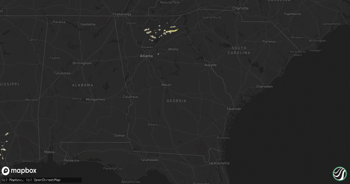
Hail Map in Georgia on April 25, 2025
Get this storm
April 25 map
$229
one time, instant access
Download today. No call, no setup
Keep the $229
Bought the map and want the full workflow? Apply the entire $229 to a subscription within 7 days. None of it is wasted.
Every map, not just this one
This buys you this map. Subscription and you get every map we run, in the markets you choose from a few cities to whole states to nationwide. Plus real-time alerts the moment a storm fires.
Contact data
Name, contact info, occupancy, even credit band for addresses in the footprint. You go from where it hit to who to call.
Become the source they trust
Unlimited branding weather history reports on demand. You already have the documented answer ready for the property owner, and you are the one who showed up with it.
Property data and RoofTrace estimates
Pull up any address you have got, its value and the exact code rules for that jurisdiction, straight from One Click Code. Then RoofTrace estimates the squares, pitch, and roof value, priced the way you price.
Storm reports in Georgia
Georgia
| Date | Description |
|---|---|
| 04/25/20255:13 PM CDT | Several social media pictures of quarter size hail in the toccoa area. Time and location estimated via radar. |
| 04/25/20254:35 PM CDT | Report from mping: half-dollar sized hail. |
| 04/25/20254:30 PM CDT | 911 call center reported a tree down in the town of demorest. Time estimated from radar. |
| 04/25/20254:26 PM CDT | 911 call center reported a tree down in the town of alto. Time estimated from radar. |
| 04/25/20254:25 PM CDT | Corrected for time. 911 call center reported a tree down in the town of demorest. Time estimated from radar. |
| 04/25/20254:25 PM CDT | 911 call center reported quarter-sized hail in the town of cornelia. Time estimated from radar. |
| 04/25/20254:15 PM CDT | Corrected for time. 911 call center reported a tree down in the town of alto. Time estimated from radar. |
| 04/25/20253:37 PM CDT | Em sent picture of 1 inch hail which fell on the east leaf community in white county along ga 115. Near ga 384. |
| 04/24/20259:40 PM CDT | Tree and power lines down on east wolf creek rd. Time estimated from radar. |
| 04/24/20258:54 PM CDT | Tree down on us 441 north. |
| 04/24/20257:16 PM CDT | Corrects description of previous tstm wnd dmg report from 4 wsw tiger. Social media report of trees down in rabun county. Time and location estimated via radar. |
All States Impacted by Hail Map on April 25, 2025
Cities Impacted by Hail Map on April 25, 2025
- Sicily Island, LA
- Jena, LA
- Clayton, LA
- Ferriday, LA
- Columbia, MS
- Sumrall, MS
- Mccomb, MS
- Tylertown, MS
- Sudan, TX
- Kentwood, LA
- Muleshoe, TX
- Fort Stockton, TX
- Lumberton, MS
- Amherst, TX
- Fieldton, TX
- Angie, LA
- Cleveland, GA
- Vega, TX
- Earth, TX
- Bogalusa, LA
- Masterson, TX
- Poplarville, MS
- Harrisonburg, LA
- Jonesville, LA
- Lula, GA
- Franklinton, LA
- Walker, LA
- Carriere, MS
- Livingston, LA
- Bush, LA
- Cornelia, GA
- Alto, GA
- Enochs, TX
- Amarillo, TX
- Littlefield, TX
- Monterey, LA
- Moreauville, LA
- Roseland, LA
- Mount Airy, GA
- Baldwin, GA
- Pecos, TX
- Angola, LA
- Cottonport, LA
- Mansura, LA
- Friona, TX
- Simmesport, LA
- Como, MS
- Hereford, TX
- Pearl River, LA
- Batchelor, LA
- Gainesville, GA
- Amite, LA
- Sardis, MS
- Toccoa, GA
- Saint Francisville, LA
- Lettsworth, LA
- Eastanollee, GA
- Loranger, LA
- Husser, LA
- Adrian, TX
- Plaucheville, LA
- Anton, TX
- Independence, LA
- Folsom, LA
- Mentone, TX
- Wildorado, TX
- Batesville, MS
- Loving, NM
- Dahlonega, GA
- Clanton, AL
- Jal, NM
- Levelland, TX
- Broadview, NM
- Forest Hill, LA
- Cheneyville, LA
- Palmetto, LA
- Melville, LA
- Robert, LA
- Ponchatoula, LA
- Evergreen, LA
- Courtland, MS
- Grady, NM
- Mcalister, NM
- San Jon, NM
- Morrow, LA
- Shallowater, TX
- Hobbs, NM
- Pope, MS
- Hineston, LA
- Lovington, NM
- House, NM
- La Place, LA
- Oak Ridge, MO
- Millersville, MO
- Ville Platte, LA
- Salt Flat, TX
- Jasper, GA
- Talking Rock, GA
- Marble Hill, MO
- Pitkin, LA
- Enid, MS
- Oakland, MS
- Panhandle, TX
- Lubbock, TX
- Ellijay, GA
- Glenmora, LA
- Jacks Creek, TN
- Clarkesville, GA
- Nashville, KS
- Rolling Meadows, IL
- Green City, MO
- Morse, TX
- Perryton, TX
- Elburn, IL
- Scranton, KS
- Lecompton, KS
- Mount Hope, KS
- South Elgin, IL
- Dumas, TX
- Breckenridge, MO
- Smithville, MO
- Novinger, MO
- Protection, KS
- Wakarusa, KS
- Cunningham, KS
- Plattsburg, MO
- Kirksville, MO
- Lawrence, KS
- Highland Park, IL
- Tonganoxie, KS
- Farmington, IA
- Linneus, MO
- Danville, IA
- Platte City, MO
- Mineral, IL
- Oquawka, IL
- Tecumseh, KS
- Alpha, IL
- Annawan, IL
- Walton, KS
- West Burlington, IA
- Ohio, IL
- Elmdale, KS
- Lynn Center, IL
- Council Grove, KS
- Compton, IL
- Coldwater, KS
- Polo, MO
- Lake City, KS
- Browning, MO
- Oskaloosa, KS
- Wheeling, IL
- Milan, MO
- Lee, IL
- Arlington Heights, IL
- Sun City, KS
- Spearman, TX
- Burrton, KS
- Seaton, IL
- Laverne, OK
- Purdin, MO
- Mooresville, MO
- Perry, KS
- Sawyer, KS
- Dekalb, IL
- Shabbona, IL
- Aledo, IL
- Chula, MO
- Emporia, KS
- Donnellson, IA
- Buffalo, OK
- Cedar Point, KS
- Stinnett, TX
- Pretty Prairie, KS
- Queen City, MO
- Luray, MO
- Greentop, MO
- Schaumburg, IL
- Harveyville, KS
- Walnut, IL
- West Brooklyn, IL
- Maple Park, IL
- Chillicothe, MO
- Lansing, KS
- Newton, KS
- North Newton, KS
- Deerfield, IL
- Downing, MO
- Kingman, KS
- Rosston, OK
- Reading, KS
- Memphis, MO
- Alexis, IL
- Americus, KS
- Woodhull, IL
- Isabel, KS
- Berryton, KS
- Saint Charles, IL
- Paw Paw, IL
- Lathrop, MO
- Haven, KS
- Sperry, IA
- Burlington, IA
- Streamwood, IL
- Atkinson, IL
- Waterman, IL
- Sublette, IL
- Northbrook, IL
- Arbela, MO
- Marion, KS
- Kahoka, MO
- West Point, IA
- North Henderson, IL
- Balko, OK
- Trimble, MO
- Middletown, IA
- Farley, MO
- Booker, TX
- Peabody, KS
- Cambridge, IL
- Allen, KS
- Hoffman Estates, IL
- Palatine, IL
- Little York, IL
- Halstead, KS
- Leavenworth, KS
- Medicine Lodge, KS
- Holt, MO
- Elgin, IL
- Sunray, TX
- Florence, KS
- Sedgwick, KS
- Kansas City, MO
- Green Castle, MO
- Kingston, MO
- McLouth, KS
- Hamilton, MO
- Burlingame, KS
- Amboy, IL
- Strong City, KS
- Steward, IL
- Wheeling, MO
- New Windsor, IL
- Sheffield, IL
- Carbondale, KS
- Wilmore, KS
- Melrose, NM
- Wolf Lake, IL
- Jonesboro, IL
- Reagan, TN
- Tatum, NM
- Mcdonald, NM
- Barstow, TX
- Dawsonville, GA
- Anna, IL
- Moore, ID
- Smyer, TX
- Tucumcari, NM
- Crossroads, NM
- Qulin, MO
- Marble Hill, GA
- Milnesand, NM
- Morton, TX
- Causey, NM
- Rogers, NM
- Cumming, GA
- Ball Ground, GA
- Maple, TX
- Pep, NM
- Texico, NM
- Murrayville, GA
- Clovis, NM
- Bovina, TX
- Dimmitt, TX
- Westminster, SC
- Long Creek, SC
- Snellville, GA
- Conyers, GA
- Loganville, GA
- Carlsbad, NM
- Fort Sumner, NM
- Springlake, TX
- Olton, TX
- Hart, TX
- Groom, TX
- Quitaque, TX
- Turkey, TX
- Happy, TX
- Childress, TX
- Canyon, TX
- Demorest, GA
- Nazareth, TX
- Lakeview, TX
- Taiban, NM
- Floyd, NM
- Dodson, TX
- Hollis, OK
- Tipton, OK
- Vernon, TX
- Davidson, OK
- Frederick, OK
- Quanah, TX
- Hollister, OK
- Loveland, OK
- Indiahoma, OK
- Paducah, TX
- Chattanooga, OK
- Cache, OK
- Eldorado, OK
- Walters, OK
- Faxon, OK
- Lawton, OK
- Chillicothe, TX
- Geronimo, OK
- Mount Hermon, LA
- Holden, LA


