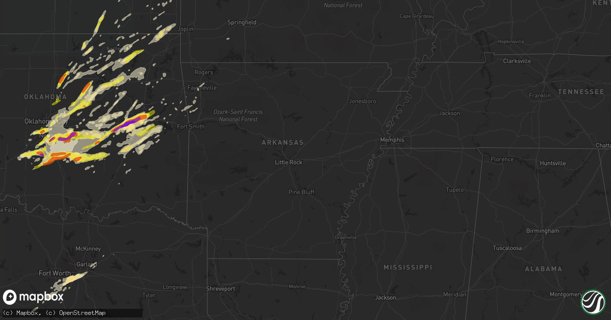
Hail Map in Arkansas on April 25, 2017
Get this storm
April 25 map
$229
one time, instant access
Download today. No call, no setup
Keep the $229
Bought the map and want the full workflow? Apply the entire $229 to a subscription within 7 days. None of it is wasted.
Every map, not just this one
This buys you this map. Subscription and you get every map we run, in the markets you choose from a few cities to whole states to nationwide. Plus real-time alerts the moment a storm fires.
Contact data
Name, contact info, occupancy, even credit band for addresses in the footprint. You go from where it hit to who to call.
Become the source they trust
Unlimited branding weather history reports on demand. You already have the documented answer ready for the property owner, and you are the one who showed up with it.
Property data and RoofTrace estimates
Pull up any address you have got, its value and the exact code rules for that jurisdiction, straight from One Click Code. Then RoofTrace estimates the squares, pitch, and roof value, priced the way you price.
Storm reports in Arkansas
Arkansas
| Date | Description |
|---|---|
| 04/25/201712:58 PM CDT | Part of a tin roof torn off a barn. Time is radar estimated. |
| 04/25/20172:22 AM CDT | Tree was blown down across highway 62. |
| 04/25/20171:30 AM CDT | Numerous trees down in town and at the holiday isle golf course. Relayed via social media. |
| 04/25/20171:25 AM CDT | A nws survey team confirmed the damage near holiday island was produced by a tornado. The survey is still underway and not complete. The highest rated damage so far is |
| 04/25/20171:25 AM CDT | Numerous trees down and some damage to roofs in and around holiday island |
| 04/25/20171:15 AM CDT | One inch treee limbs broken |
| 04/25/20171:11 AM CDT | Large tree limbs down...possible damage to carport. Estimated 70 mph. |
| 04/25/20171:10 AM CDT | Tree down across n davis road |
| 04/25/20171:08 AM CDT | A couple of trees down |
| 04/25/20171:07 AM CDT | Tree down on a house in little flock ar. |
| 04/25/20171:06 AM CDT | Wind estimated to 65 mph 2.25 miles south of the rogers airport...trees down in the area |
| 04/25/20171:05 AM CDT | Small tree down on a house...numerous large limbs down |
| 04/25/20171:05 AM CDT | Trees down in bentonville |
| 04/25/20171:05 AM CDT | A local report indicates 60 MPH wind near BENTONVILLE |
| 04/25/20171:00 AM CDT | Small tree fell on home causing roof damage |
| 04/25/201712:58 AM CDT | Part of a tin roof torn off a barn. Time is radar estimated. |
| 04/25/201712:57 AM CDT | Measured by asos at nw arkansas regional airport. |
Cities Impacted by Hail Map on April 25, 2017
- Perry, OK
- Ralston, OK
- Mulhall, OK
- Pawnee, OK
- Coyle, OK
- Morrison, OK
- Stillwater, OK
- Beggs, OK
- Mounds, OK
- Paden, OK
- Okemah, OK
- Boley, OK
- Burbank, OK
- Shidler, OK
- Stigler, OK
- Kinta, OK
- Delaware, OK
- Cushing, OK
- Yale, OK
- Bristow, OK
- Depew, OK
- Mansfield, TX
- West Fork, AR
- Claremore, OK
- Muskogee, OK
- Warner, OK
- Oktaha, OK
- Checotah, OK
- Lane, OK
- Tecumseh, OK
- Maud, OK
- Skiatook, OK
- Konawa, OK
- Wewoka, OK
- Council Hill, OK
- Eufaula, OK
- Henryetta, OK
- Mcalester, OK
- Porum, OK
- Quinton, OK
- Whitefield, OK
- Broken Arrow, OK
- Independence, KS
- Pleasanton, KS
- Prescott, KS
- Cedar Vale, KS
- Moline, KS
- Ramona, OK
- Pittsburg, OK
- Cedar Hill, TX
- Desoto, TX
- Dallas, TX
- Duncanville, TX
- Girard, KS
- Ada, OK
- Stratford, OK
- Seminole, OK
- Fairfax, OK
- McCune, KS
- Davenport, OK
- Norman, OK
- Oklahoma City, OK
- Jones, OK
- Meeker, OK
- Mannford, OK
- Owasso, OK
- Harrah, OK
- Stroud, OK
- Tuttle, OK
- Sapulpa, OK
- Drumright, OK
- Tulsa, OK
- Luther, OK
- Jennings, OK
- Spencer, OK
- Newcastle, OK
- Chandler, OK
- Blanchard, OK
- Choctaw, OK
- Catoosa, OK
- Sand Springs, OK
- Wellston, OK
- Lindsay, OK
- Stonewall, OK
- Fitzhugh, OK
- Prague, OK
- Byars, OK
- Rose, OK
- Rush Springs, OK
- Alex, OK
- Ninnekah, OK
- Bradley, OK
- Cement, OK
- Hominy, OK
- Glencoe, OK
- Wetumka, OK
- Sedan, KS
- Lincoln, MO
- Warsaw, MO
- Noble, OK
- Earlsboro, OK
- Purcell, OK
- Washington, OK
- Shawnee, OK
- Macomb, OK
- Lexington, OK
- Galena, KS
- Columbus, KS
- Bluejacket, OK
- Vinita, OK
- Welch, OK
- Baxter Springs, KS
- Miami, OK
- Chetopa, KS
- Boynton, OK
- Dewey, OK
- Nowata, OK
- Bartlesville, OK
- Lenapah, OK
- Bixby, OK
- Meridian, OK
- Holdenville, OK
- Calvin, OK
- Allen, OK
- El Dorado Springs, MO
- Barnsdall, OK
- Osage, OK
- Adair, OK
- Big Cabin, OK
- Morris, OK
- Haskell, OK
- Talala, OK
- Wayne, OK
- Maysville, OK
- Pauls Valley, OK
- Paoli, OK
- Muldrow, OK
- Venus, TX
- Alvarado, TX
- Midlothian, TX
- Okmulgee, OK
- Rush Hill, MO
- Pryor, OK
- Walnut Springs, TX
- Morgan, TX
- Iredell, TX
- Hartshorne, OK
- Wilburton, OK
- Grand Prairie, TX
- Lamar, OK
- Pawhuska, OK
- Chickasha, OK
- Locust Grove, OK
- Inola, OK
- Farmington, AR
- Fayetteville, AR
- Porter, OK
- Springdale, AR
- Bunch, OK
- Laddonia, MO
- Benton City, MO
- Mexico, MO
- Arlington, TX
- Wynnewood, OK
- Crowder, OK
- Salina, OK
- Chouteau, OK
- Red Oak, OK
- Collinsville, OK
- Keota, OK
- Taft, OK
- Wanette, OK
- Copan, OK
- Wynona, OK
- Vian, OK
- S Coffeyville, OK
- Wann, OK
- Marlow, OK
- Atwood, OK
- Asher, OK
- Caddo Mills, TX
- Castle, OK
- Barry, IL
- Oswego, KS
- Mccurtain, OK
- Vera, OK
- Ochelata, OK
- Guthrie, OK
- Cleburne, TX
- Itasca, TX
- Amber, OK
- Milo, MO
- Nevada, MO
- Rockwall, TX
- New Haven, MO
- Marthasville, MO
- Berger, MO
- Fort Worth, TX
- Tupelo, OK
- Sallisaw, OK
- Park Hill, OK
- Tahlequah, OK
- Keene, TX
- Godley, TX
- Walnut, KS
- Crane, MO
- Sparks, OK
- Burleson, TX
- Joshua, TX
- Dustin, OK
- Elk Falls, KS
- Stilwell, OK
- Havana, KS
- Parsons, KS
- Fredonia, KS
- Braggs, OK
- Sasakwa, OK
- Weleetka, OK
- Hanna, OK
- Elk City, KS
- Natural Dam, AR
- Grandview, TX
- Coffeyville, KS
- Galesburg, KS
- Erie, KS
- Greenville, TX
- Cedarville, AR
- Maramec, OK
- Cleveland, OK
- Foster, OK
- Mcloud, OK
- Fletcher, OK
- Webbers Falls, OK
- Kellyville, OK
- Stuart, OK
- Sperry, OK
- Chelsea, OK
- Canadian, OK
- Roff, OK
- Agra, OK
- Terlton, OK
- Elmore City, OK
- Gore, OK
- Savanna, OK
- Indianola, OK
- Tryon, OK
- Newalla, OK
- Lincoln, AR
- Stringtown, OK
- Daisy, OK
- Kennedale, TX
- Mesquite, TX
- Balch Springs, TX
- Lillian, TX
- Jenks, OK
- Sheldon, MO
- Jerico Springs, MO
- Butler, MO
- Glenpool, OK
- Chester, AR
- Rowlett, TX
- Garland, TX
- Orlando, OK
- Edmond, OK
- Carney, OK


