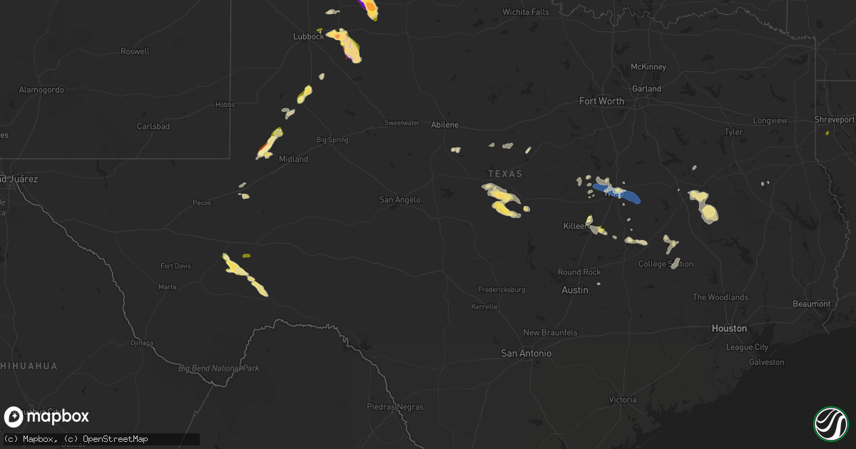
Hail Map in Texas on April 24, 2025
Get this storm
April 24 map
$229
one time, instant access
Download today. No call, no setup
Keep the $229
Bought the map and want the full workflow? Apply the entire $229 to a subscription within 7 days. None of it is wasted.
Every map, not just this one
This buys you this map. Subscription and you get every map we run, in the markets you choose from a few cities to whole states to nationwide. Plus real-time alerts the moment a storm fires.
Contact data
Name, contact info, occupancy, even credit band for addresses in the footprint. You go from where it hit to who to call.
Become the source they trust
Unlimited branding weather history reports on demand. You already have the documented answer ready for the property owner, and you are the one who showed up with it.
Property data and RoofTrace estimates
Pull up any address you have got, its value and the exact code rules for that jurisdiction, straight from One Click Code. Then RoofTrace estimates the squares, pitch, and roof value, priced the way you price.
Storm reports in Texas
Texas
| Date | Description |
|---|---|
| 04/24/20256:52 PM CDT | A local report indicates 2.00 inch wind near 6 NE Pringle |
| 04/24/20256:48 PM CDT | A tree was downed across a power line on county road 6102 on the southwest side of nacogdoches. |
| 04/24/20256:46 PM CDT | A local report indicates 1.00 inch wind near 1 SSE Borger |
| 04/24/20256:45 PM CDT | A local report indicates 1.25 inch wind near 6 ENE Pringle |
| 04/24/20256:33 PM CDT | Nssl report. |
| 04/24/20256:13 PM CDT | Report from mping: quarter |
| 04/24/20256:10 PM CDT | Multiple reports confirmed via video feed. |
| 04/24/20255:57 PM CDT | Report from mping: ping pong ball |
| 04/24/20255:50 PM CDT | Mping. |
| 04/24/20255:10 PM CDT | Multiple trees and power lines were downed across cherokee county. |
| 04/24/20254:30 PM CDT | Trees and power lines blown down along hwy 7 between fm 542 and the trinity river... And a hay barn was blown down on the north side of hwy 7 near trinity river. |
| 04/24/20252:38 PM CDT | Delayed report. Roof damage to home and several broken tree limbs in the same area. Time estimated by radar. |
| 04/24/20252:10 PM CDT | Significant wind damage to a fast food restaurant on north valley mills drive. Time estimated by radar. |
| 04/24/20252:09 PM CDT | 67 mph gust measured at waco regional airport. |
| 04/24/20251:52 PM CDT | Photo of large tree downed and damaged powerlines in china spring. |
| 04/23/202510:55 PM CDT | Second hand report from fire chief. |
| 04/23/20259:51 PM CDT | A local report indicates a tornado near 13 ENE Post |
| 04/23/20259:33 PM CDT | Powerlines were blown down on a car and report of a person trapped in the car. This was estimated to be located along highway 283 northwest of miami approx 2 miles nort |
| 04/23/20259:30 PM CDT | Broadcast livestream indicated some fencing damage and power lines down at highway 283 north of miami at quarter horse road. |
| 04/23/20259:22 PM CDT | A local report indicates a tornado near 12 NE Post |
| 04/23/20259:05 PM CDT | Several reports of tornado on the ground east of hwy70. |
| 04/23/20258:50 PM CDT | A local report indicates 2.00 inch wind near 7 S Spearman |
| 04/23/20258:50 PM CDT | Brief touchdown occurred. |
| 04/23/20258:15 PM CDT | Potentially as wide as 1/4 mile at greatest intensity. |
| 04/23/20258:02 PM CDT | Brief tornado observed. |
| 04/23/20258:02 PM CDT | Multiple reports. |
| 04/23/20258:01 PM CDT | A local report indicates 5.00 inch wind near Matador |
| 04/23/20257:35 PM CDT | Short lived tornado. Crosby so. |
| 04/23/20257:35 PM CDT | A local report indicates 1.75 inch wind near 1 SSE Spearman |
| 04/23/20257:27 PM CDT | Via x...measured with calipers. Exact location estimated with radar. |
| 04/23/20257:21 PM CDT | A local report indicates 3.00 inch wind near 9 SSW Spearman |
| 04/23/20257:20 PM CDT | Report from mping: tennis ball |
| 04/23/20257:15 PM CDT | Report from mping: grapefruit |
| 04/23/20257:15 PM CDT | Multiple public and spotter reports. |
| 04/23/20257:14 PM CDT | A local report indicates 1.50 inch wind near 9 WNW Waka |
| 04/23/20257:10 PM CDT | Delayed report. |
| 04/23/20257:04 PM CDT | A local report indicates 1.25 inch wind near Gruver |
| 04/23/20257:02 PM CDT | Report from mping: grapefruit |
| 04/23/20257:02 PM CDT | A local report indicates 4.00 inch wind near 7 ESE South Plains |
| 04/23/20257:01 PM CDT | Report from mping: hen egg+ |
| 04/23/20257:00 PM CDT | Via x ...tape measured. |
| 04/23/20257:00 PM CDT | A local report indicates 1.00 inch wind near Spearman |
All States Impacted by Hail Map on April 24, 2025
Cities Impacted by Hail Map on April 24, 2025
- Sterling City, TX
- New Iberia, LA
- Jeanerette, LA
- Ovalo, TX
- Clyde, TX
- Viola, KS
- Cisco, TX
- Rising Star, TX
- Cheney, KS
- Clearwater, KS
- Carbon, TX
- Comanche, TX
- Gorman, TX
- De Leon, TX
- Dublin, TX
- Bangs, TX
- Brownwood, TX
- Brookesmith, TX
- Mullin, TX
- Early, TX
- Goldthwaite, TX
- Jonesboro, TX
- Richland Springs, TX
- Rochelle, TX
- Valley Mills, TX
- Clifton, TX
- San Saba, TX
- Crawford, TX
- China Spring, TX
- McGregor, TX
- Waco, TX
- Woodway, TX
- Oxford, GA
- Counce, TN
- Savannah, TN
- Riesel, TX
- Mart, TX
- Gatesville, TX
- Moody, TX
- Temple, TX
- Butler, GA
- Covington, GA
- Mauk, GA
- Junction City, GA
- Talbotton, GA
- Loganville, GA
- Axtell, TX
- Groesbeck, TX
- Marlin, TX
- Belton, TX
- Hillsboro, GA
- Fort Hood, TX
- Monroe, GA
- Tennessee Colony, TX
- Moulton, AL
- Reynolds, GA
- Rosebud, TX
- Fountain, FL
- Altha, FL
- Strang, NE
- Oakwood, TX
- Buffalo, TX
- Bruning, NE
- Rogers, TX
- Teague, TX
- Fort Stockton, TX
- Burlington, TX
- Buckholts, TX
- Cameron, TX
- Alford, FL
- Bluffton, GA
- Blakely, GA
- Ohiowa, NE
- Reagan, TX
- Parker, CO
- Conyers, GA
- Franktown, CO
- Elizabeth, CO
- Fort Gaines, GA
- Hudson, CO
- Fort Lupton, CO
- Papillion, NE
- La Vista, NE
- Omaha, NE
- Victoria, KS
- Springfield, NE
- Council Bluffs, IA
- Ashland, KS
- Buffalo, OK
- Meade, KS
- Dwight, KS
- Council Grove, KS
- Calvert, TX
- Hearne, TX
- Bryan, TX
- Elkhart, TX
- Grapeland, TX
- Centerville, TX
- Alexandria, NE
- Belvidere, NE
- Gorham, KS
- College Station, TX
- Franklin, TX
- Social Circle, GA
- Carter Lake, IA
- Kiowa, CO
- Brighton, CO
- Crescent, IA
- Fowler, KS
- Crockett, TX
- Alta Vista, KS
- Ideal, GA
- Oglethorpe, GA
- North Zulch, TX
- Anderson, TX
- Underwood, IA
- Honey Creek, IA
- Hays, KS
- Iola, TX
- Elkhorn, NE
- Lovelady, TX
- Greeley, CO
- Gill, CO
- Englewood, KS
- Waterloo, NE
- Kress, TX
- Elgin, TX
- Grenville, NM
- Eaton, CO
- Galeton, CO
- Silverton, TX
- Beeler, KS
- Marshallville, GA
- La Salle, CO
- Pfeifer, KS
- Bennington, NE
- Garfield, GA
- Almena, KS
- Long Island, KS
- Monahans, TX
- Montezuma, GA
- Freedom, OK
- Midville, GA
- Bellevue, NE
- Fairbury, NE
- Lucerne, CO
- Goldsmith, TX
- Briggsdale, CO
- Simla, CO
- Ramah, CO
- Millen, GA
- Silver City, IA
- Mineola, IA
- Lockney, TX
- Andrews, TX
- Neola, IA
- Treynor, IA
- Rupert, GA
- Gate, OK
- Rosston, OK
- Minneola, KS
- Douglass, TX
- Floydada, TX
- Petersburg, TX
- Jetmore, KS
- Diller, NE
- Cushing, TX
- Hebron, NE
- Gilead, NE
- Nacogdoches, TX
- Oakland, IA
- Carson, IA
- Logan, IA
- Jansen, NE
- Panhandle, TX
- Borger, TX
- Stinnett, TX
- Spearman, TX
- Gruver, TX
- Flomot, TX
- Lorenzo, TX
- Bremen, GA
- Temple, GA
- Slaton, TX
- Odell, NE
- Matheson, CO
- Ralls, TX
- Matador, TX
- Ness City, KS
- La Crosse, KS
- Casey, IA
- Hanston, KS
- Wymore, NE
- Hugo, CO
- Adair, IA
- Crosbyton, TX
- Burdett, KS
- Lamesa, TX
- Alva, OK
- Villa Rica, GA
- Minden, IA
- Kinsley, KS
- Larned, KS
- Stuart, IA
- Menlo, IA
- Rush, CO
- Guthrie Center, IA
- Yoder, CO
- Welch, TX
- Perryton, TX
- Miami, TX
- Oketo, KS
- Mooreland, OK
- Spearville, KS
- Bazine, KS
- Roaring Springs, TX
- Wright, KS
- Steele City, NE
- Greenleaf, KS
- Home, KS
- Beattie, KS
- Marysville, KS
- Frankfort, KS
- Axtell, KS
- Vermillion, KS
- Washington, KS
- Linn, KS
- Offerle, KS
- Limon, CO
- Dodge City, KS
- Brownell, KS
- Lewis, KS
- Kit Carson, CO
- Waynoka, OK
- Karval, CO
- Hanover, KS
- Hollenberg, KS
- Spur, TX
- Snyder, TX
- Laverne, OK
- Tahoka, TX
- Ellis, KS
- Justiceburg, TX
- Post, TX
- Audubon, IA
- Bremen, KS
- Odonnell, TX
- McCracken, KS
- Keithville, LA
- Idalou, TX
- Lubbock, TX
- Aline, OK
- Carmen, OK
- Dacoma, OK
- Ordway, CO
- Eads, CO
- Bethune, CO
- Morse, TX
- May, OK
- Utica, KS
- Afton, TX
- Mcadoo, TX
- Chester, OK
- Arnold, KS
- Fargo, OK
- Seminole, TX
- Luray, KS
- Fort Supply, OK
- Woodward, OK
- Ransom, KS
- Wakeeney, KS
- Plainville, KS
- Pueblo, CO
- Lucas, KS
- Cherokee, OK
- Fairview, OK
- Avondale, CO
- Canadian, TX
- Hill City, KS
- Hunter, KS
- Miltonvale, KS
- Mobeetie, TX
- Wheeler, TX
- Dryden, TX
- Sylvan Grove, KS
- Bogue, KS
- Ringwood, OK
- Cleo Springs, OK
- Okeene, OK
- Isabella, OK
- Sheridan Lake, CO
- Green, KS
- Randolph, KS
- Barnes, KS
- Rock Port, MO
- Ogallah, KS
- Stockton, KS
- Briscoe, TX
- Pampa, TX
- Leonardville, KS
- Saint Francis, KS
- Hardesty, OK
- Collyer, KS
- Ames, OK
- Damar, KS
- Beloit, KS
- Tipton, KS
- Catharine, KS
- Park, KS
- Quinter, KS
- Concordia, KS
- Delphos, KS
- Glasco, KS
- Osborne, KS
- Balko, OK
- Oakwood, OK
- Waldo, KS
- Palco, KS
- Hammon, OK
- Cheyenne, OK
- Mutual, OK
- Bird City, KS
- Crawford, OK
- Fairfax, MO
- Butler, OK
- Aurora, KS
- Kansas City, KS
- Shawnee, KS
- Vici, OK
- Kingfisher, OK
- Elk City, OK
- Watonga, OK
- Canton, OK
- Custer City, OK
- Lenexa, KS
- McDonald, KS
- Edson, KS
- Durham, OK
- Fay, OK
- Clinton, OK
- Thomas, OK
- Corn, OK
- Hydro, OK
- Sublette, KS
- Colony, OK
- Plains, KS
- Binger, OK
- Lookeba, OK
- Gracemont, OK
- Montezuma, KS
- Ulysses, KS
- Olney Springs, CO
- Garfield, KS
- Coldwater, KS
- Wilmore, KS
- Rocky Ford, CO
- Lake City, KS
- Emporia, KS
- La Junta, CO
- Satanta, KS
- Evans, CO


