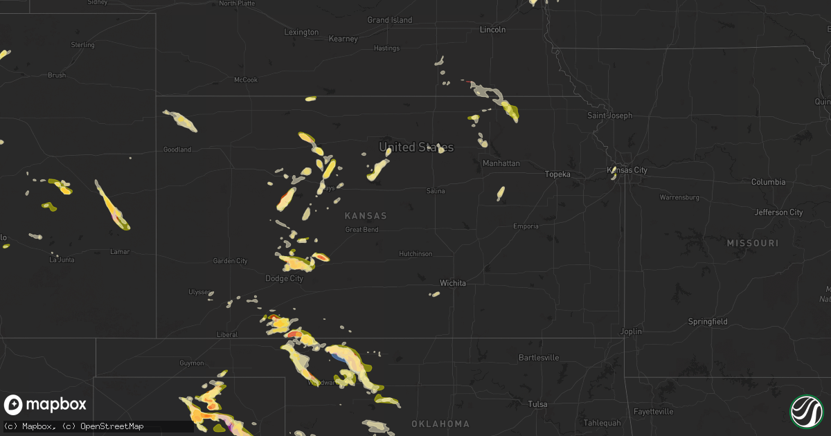
Hail Map in Kansas on April 24, 2025
Get this storm
April 24 map
$229
one time, instant access
Download today. No call, no setup
Keep the $229
Bought the map and want the full workflow? Apply the entire $229 to a subscription within 7 days. None of it is wasted.
Every map, not just this one
This buys you this map. Subscription and you get every map we run, in the markets you choose from a few cities to whole states to nationwide. Plus real-time alerts the moment a storm fires.
Contact data
Name, contact info, occupancy, even credit band for addresses in the footprint. You go from where it hit to who to call.
Become the source they trust
Unlimited branding weather history reports on demand. You already have the documented answer ready for the property owner, and you are the one who showed up with it.
Property data and RoofTrace estimates
Pull up any address you have got, its value and the exact code rules for that jurisdiction, straight from One Click Code. Then RoofTrace estimates the squares, pitch, and roof value, priced the way you price.
Storm reports in Kansas
Kansas
| Date | Description |
|---|---|
| 04/24/20255:50 PM CDT | A local report indicates 1.75 inch wind near 9 NW Englewood |
| 04/24/20254:32 PM CDT | Time estimated from radar. |
| 04/23/202511:45 PM CDT | Report from mping: quarter |
| 04/23/202511:08 PM CDT | A few quarter size stones spotted. |
| 04/23/20258:18 PM CDT | A local report indicates 1.00 inch wind near 5 NE Kinsley |
| 04/23/20258:10 PM CDT | A local report indicates 1.50 inch wind near 9 WNW Spearville |
| 04/23/20258:06 PM CDT | Report from mping: quarter |
| 04/23/20257:59 PM CDT | A local report indicates 1.00 inch wind near 9 S Rozel |
| 04/23/20257:55 PM CDT | A local report indicates 1.00 inch wind near 6 WSW Beattie |
| 04/23/20257:54 PM CDT | A local report indicates 2.00 inch wind near 9 WNW Spearville |
| 04/23/20257:53 PM CDT | Report from social media with video. |
| 04/23/20257:32 PM CDT | A local report indicates 1.00 inch wind near 7 SSW Jetmore |
All States Impacted by Hail Map on April 24, 2025
Cities Impacted by Hail Map on April 24, 2025
- Sterling City, TX
- New Iberia, LA
- Jeanerette, LA
- Ovalo, TX
- Clyde, TX
- Viola, KS
- Cisco, TX
- Rising Star, TX
- Cheney, KS
- Clearwater, KS
- Carbon, TX
- Comanche, TX
- Gorman, TX
- De Leon, TX
- Dublin, TX
- Bangs, TX
- Brownwood, TX
- Brookesmith, TX
- Mullin, TX
- Early, TX
- Goldthwaite, TX
- Jonesboro, TX
- Richland Springs, TX
- Rochelle, TX
- Valley Mills, TX
- Clifton, TX
- San Saba, TX
- Crawford, TX
- China Spring, TX
- McGregor, TX
- Waco, TX
- Woodway, TX
- Oxford, GA
- Counce, TN
- Savannah, TN
- Riesel, TX
- Mart, TX
- Gatesville, TX
- Moody, TX
- Temple, TX
- Butler, GA
- Covington, GA
- Mauk, GA
- Junction City, GA
- Talbotton, GA
- Loganville, GA
- Axtell, TX
- Groesbeck, TX
- Marlin, TX
- Belton, TX
- Hillsboro, GA
- Fort Hood, TX
- Monroe, GA
- Tennessee Colony, TX
- Moulton, AL
- Reynolds, GA
- Rosebud, TX
- Fountain, FL
- Altha, FL
- Strang, NE
- Oakwood, TX
- Buffalo, TX
- Bruning, NE
- Rogers, TX
- Teague, TX
- Fort Stockton, TX
- Burlington, TX
- Buckholts, TX
- Cameron, TX
- Alford, FL
- Bluffton, GA
- Blakely, GA
- Ohiowa, NE
- Reagan, TX
- Parker, CO
- Conyers, GA
- Franktown, CO
- Elizabeth, CO
- Fort Gaines, GA
- Hudson, CO
- Fort Lupton, CO
- Papillion, NE
- La Vista, NE
- Omaha, NE
- Victoria, KS
- Springfield, NE
- Council Bluffs, IA
- Ashland, KS
- Buffalo, OK
- Meade, KS
- Dwight, KS
- Council Grove, KS
- Calvert, TX
- Hearne, TX
- Bryan, TX
- Elkhart, TX
- Grapeland, TX
- Centerville, TX
- Alexandria, NE
- Belvidere, NE
- Gorham, KS
- College Station, TX
- Franklin, TX
- Social Circle, GA
- Carter Lake, IA
- Kiowa, CO
- Brighton, CO
- Crescent, IA
- Fowler, KS
- Crockett, TX
- Alta Vista, KS
- Ideal, GA
- Oglethorpe, GA
- North Zulch, TX
- Anderson, TX
- Underwood, IA
- Honey Creek, IA
- Hays, KS
- Iola, TX
- Elkhorn, NE
- Lovelady, TX
- Greeley, CO
- Gill, CO
- Englewood, KS
- Waterloo, NE
- Kress, TX
- Elgin, TX
- Grenville, NM
- Eaton, CO
- Galeton, CO
- Silverton, TX
- Beeler, KS
- Marshallville, GA
- La Salle, CO
- Pfeifer, KS
- Bennington, NE
- Garfield, GA
- Almena, KS
- Long Island, KS
- Monahans, TX
- Montezuma, GA
- Freedom, OK
- Midville, GA
- Bellevue, NE
- Fairbury, NE
- Lucerne, CO
- Goldsmith, TX
- Briggsdale, CO
- Simla, CO
- Ramah, CO
- Millen, GA
- Silver City, IA
- Mineola, IA
- Lockney, TX
- Andrews, TX
- Neola, IA
- Treynor, IA
- Rupert, GA
- Gate, OK
- Rosston, OK
- Minneola, KS
- Douglass, TX
- Floydada, TX
- Petersburg, TX
- Jetmore, KS
- Diller, NE
- Cushing, TX
- Hebron, NE
- Gilead, NE
- Nacogdoches, TX
- Oakland, IA
- Carson, IA
- Logan, IA
- Jansen, NE
- Panhandle, TX
- Borger, TX
- Stinnett, TX
- Spearman, TX
- Gruver, TX
- Flomot, TX
- Lorenzo, TX
- Bremen, GA
- Temple, GA
- Slaton, TX
- Odell, NE
- Matheson, CO
- Ralls, TX
- Matador, TX
- Ness City, KS
- La Crosse, KS
- Casey, IA
- Hanston, KS
- Wymore, NE
- Hugo, CO
- Adair, IA
- Crosbyton, TX
- Burdett, KS
- Lamesa, TX
- Alva, OK
- Villa Rica, GA
- Minden, IA
- Kinsley, KS
- Larned, KS
- Stuart, IA
- Menlo, IA
- Rush, CO
- Guthrie Center, IA
- Yoder, CO
- Welch, TX
- Perryton, TX
- Miami, TX
- Oketo, KS
- Mooreland, OK
- Spearville, KS
- Bazine, KS
- Roaring Springs, TX
- Wright, KS
- Steele City, NE
- Greenleaf, KS
- Home, KS
- Beattie, KS
- Marysville, KS
- Frankfort, KS
- Axtell, KS
- Vermillion, KS
- Washington, KS
- Linn, KS
- Offerle, KS
- Limon, CO
- Dodge City, KS
- Brownell, KS
- Lewis, KS
- Kit Carson, CO
- Waynoka, OK
- Karval, CO
- Hanover, KS
- Hollenberg, KS
- Spur, TX
- Snyder, TX
- Laverne, OK
- Tahoka, TX
- Ellis, KS
- Justiceburg, TX
- Post, TX
- Audubon, IA
- Bremen, KS
- Odonnell, TX
- McCracken, KS
- Keithville, LA
- Idalou, TX
- Lubbock, TX
- Aline, OK
- Carmen, OK
- Dacoma, OK
- Ordway, CO
- Eads, CO
- Bethune, CO
- Morse, TX
- May, OK
- Utica, KS
- Afton, TX
- Mcadoo, TX
- Chester, OK
- Arnold, KS
- Fargo, OK
- Seminole, TX
- Luray, KS
- Fort Supply, OK
- Woodward, OK
- Ransom, KS
- Wakeeney, KS
- Plainville, KS
- Pueblo, CO
- Lucas, KS
- Cherokee, OK
- Fairview, OK
- Avondale, CO
- Canadian, TX
- Hill City, KS
- Hunter, KS
- Miltonvale, KS
- Mobeetie, TX
- Wheeler, TX
- Dryden, TX
- Sylvan Grove, KS
- Bogue, KS
- Ringwood, OK
- Cleo Springs, OK
- Okeene, OK
- Isabella, OK
- Sheridan Lake, CO
- Green, KS
- Randolph, KS
- Barnes, KS
- Rock Port, MO
- Ogallah, KS
- Stockton, KS
- Briscoe, TX
- Pampa, TX
- Leonardville, KS
- Saint Francis, KS
- Hardesty, OK
- Collyer, KS
- Ames, OK
- Damar, KS
- Beloit, KS
- Tipton, KS
- Catharine, KS
- Park, KS
- Quinter, KS
- Concordia, KS
- Delphos, KS
- Glasco, KS
- Osborne, KS
- Balko, OK
- Oakwood, OK
- Waldo, KS
- Palco, KS
- Hammon, OK
- Cheyenne, OK
- Mutual, OK
- Bird City, KS
- Crawford, OK
- Fairfax, MO
- Butler, OK
- Aurora, KS
- Kansas City, KS
- Shawnee, KS
- Vici, OK
- Kingfisher, OK
- Elk City, OK
- Watonga, OK
- Canton, OK
- Custer City, OK
- Lenexa, KS
- McDonald, KS
- Edson, KS
- Durham, OK
- Fay, OK
- Clinton, OK
- Thomas, OK
- Corn, OK
- Hydro, OK
- Sublette, KS
- Colony, OK
- Plains, KS
- Binger, OK
- Lookeba, OK
- Gracemont, OK
- Montezuma, KS
- Ulysses, KS
- Olney Springs, CO
- Garfield, KS
- Coldwater, KS
- Wilmore, KS
- Rocky Ford, CO
- Lake City, KS
- Emporia, KS
- La Junta, CO
- Satanta, KS
- Evans, CO


