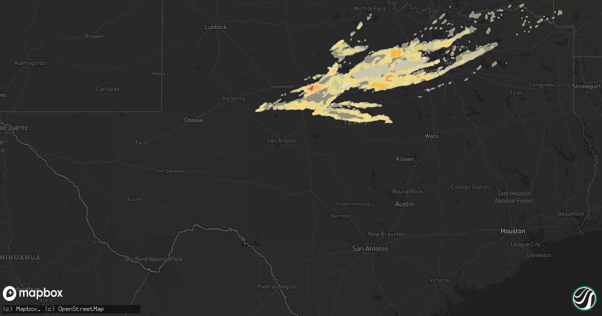
Hail Map in Texas on April 24, 2011
Get this storm
April 24 map
$229
one time, instant access
Download today. No call, no setup
Keep the $229
Bought the map and want the full workflow? Apply the entire $229 to a subscription within 7 days. None of it is wasted.
Every map, not just this one
This buys you this map. Subscription and you get every map we run, in the markets you choose from a few cities to whole states to nationwide. Plus real-time alerts the moment a storm fires.
Contact data
Name, contact info, occupancy, even credit band for addresses in the footprint. You go from where it hit to who to call.
Become the source they trust
Unlimited branding weather history reports on demand. You already have the documented answer ready for the property owner, and you are the one who showed up with it.
Property data and RoofTrace estimates
Pull up any address you have got, its value and the exact code rules for that jurisdiction, straight from One Click Code. Then RoofTrace estimates the squares, pitch, and roof value, priced the way you price.
Storm reports in Texas
Texas
| Date | Description |
|---|---|
| 04/24/20116:55 PM CDT | 60 mph wind gusts in azle |
| 04/24/20116:44 PM CDT | Northwest side of decatur |
| 04/24/20116:44 PM CDT | Quarter size hail 2 north of decatur |
| 04/24/20116:43 PM CDT | 2 inch hail reported in windgate |
| 04/24/20116:38 PM CDT | A local report indicates 2.00 inch wind near 1 ENE HARPERSVILLE |
| 04/24/20116:32 PM CDT | A local report indicates 60 MPH wind near 5 SW BRIDGEPORT |
| 04/24/20116:26 PM CDT | Quarter to golf ball size hail reported in windgate. |
| 04/24/20116:25 PM CDT | Reported at intersection of fm1853 and cr 190 |
| 04/24/20116:04 PM CDT | Ping pong ball size hail 8.1 miles ene of graford |
| 04/24/20115:53 PM CDT | Quarter size hail reported in happy valley. |
| 04/24/20115:27 PM CDT | Large multi vortex tornado was reported near us 283 near the schackelford - callahan county line. |
| 04/24/20115:13 PM CDT | At 27th and willis in abilene |
| 04/24/20115:05 PM CDT | A local report indicates a tornado near 5 NW BAIRD |
| 04/24/20114:57 PM CDT | Fire department measured 3.5 inch hail 2 miles south of abilene. |
| 04/24/20114:57 PM CDT | 3 to 4 inch hail at the abilene airport reported by atct observer |
| 04/24/20114:50 PM CDT | A local report indicates 2.75 inch wind near ABILENE |
| 04/24/20114:45 PM CDT | Reports of shattered windows in dozens of vehicles near the abilene mall. |
| 04/24/20114:40 PM CDT | At the abilene airport reported by atct observer |
| 04/24/20114:34 PM CDT | A local report indicates a tornado near 3 E POTOSI |
| 04/24/20114:32 PM CDT | A local report indicates 2.00 inch wind near DYESS AFB |
| 04/24/20114:30 PM CDT | Near acu campus |
| 04/24/20114:24 PM CDT | A local report indicates a tornado near 3 N POTOSI |
| 04/24/20113:55 PM CDT | A local report indicates a tornado near 5 N MORAN |
| 04/24/20113:55 PM CDT | A local report indicates a tornado near IBEX |
| 04/24/20113:55 PM CDT | A local report indicates 1.75 inch wind near 1 SW DYESS AFB |
| 04/24/20113:55 PM CDT | Quarter size hail was reported |
| 04/24/20113:51 PM CDT | A local report indicates 1.75 inch wind near 3 SSE DYESS AFB |
| 04/24/20113:47 PM CDT | A local report indicates 1.50 inch wind near 1 NE VIEW |
| 04/24/20113:45 PM CDT | A local report indicates 1.75 inch wind near 1 N ALBANY |
| 04/24/20113:31 PM CDT | Spotter in baird sees tornado on the ground with the storm north of baird. |
| 04/24/20113:31 PM CDT | Spotter in baird sees tornado on the ground with the storm north of baird. |
| 04/24/20114:52 AM CDT | Reported on the north end of dfw airport |
| 04/24/20114:35 AM CDT | Quarter size hail was reported around davis blvd and mid cities blvd in north richland hills |
| 04/24/20114:29 AM CDT | A local report indicates 1.00 inch wind near WATAUGA |
| 04/24/20114:27 AM CDT | A local report indicates 1.00 inch wind near NORTH RICHLAND HILLS |
| 04/24/20113:29 AM CDT | A local report indicates 1.00 inch wind near RHOME |
| 04/24/20113:29 AM CDT | Near the wise co & tarrant co line |
| 04/24/20112:57 AM CDT | A local report indicates 1.00 inch wind near PARADISE |
| 04/24/20112:52 AM CDT | Quarter to baseball size hail fell in boonsville |
| 04/24/20112:45 AM CDT | A local report indicates 1.75 inch wind near WEATHERFORD |
| 04/24/20111:20 AM CDT | Dime to quarter size hail at lake coleman |
| 04/24/20111:02 AM CDT | Public report of quarter sized hail near archer city. Relayed via amateur radio. |
| 04/24/201112:32 AM CDT | Golf ball size hail reported in carlton |
| 04/24/201112:04 AM CDT | Quarter size hail at lake worth |
| 04/23/201111:52 PM CDT | In the remuda community in eastern parker county |
| 04/23/201111:50 PM CDT | A local report indicates 1.00 inch wind near BLACKWELL |
| 04/23/201111:44 PM CDT | Golf ball to hen egg size hail reported 2 miles ese of hudson oaks. Hail is covering i-20 and windshield damage was reported. |
| 04/23/201111:42 PM CDT | Golf ball size hail reported on the east side of lake weatherford |
| 04/23/201111:33 PM CDT | At fm 2861 and cr 416 |
| 04/23/201111:30 PM CDT | Half dollar size hail was reported at i-20 and lake shore drive in weatherford |
| 04/23/201111:30 PM CDT | Tennis ball hail and 45 mph winds in annetta north. |
| 04/23/201111:24 PM CDT | Highway 180 and old millsap highway |
| 04/23/201111:13 PM CDT | Golf ball hail reported 3 miles west of weatherford |
| 04/23/201111:07 PM CDT | A local report indicates 1.00 inch wind near COMANCHE |
| 04/23/201111:07 PM CDT | At fm 279 and hwy 377 between dublin and stephenville |
| 04/23/201110:52 PM CDT | In millsap |
| 04/23/201110:44 PM CDT | A local report indicates 1.75 inch wind near MAY |
| 04/23/201110:35 PM CDT | In wylie |
| 04/23/201110:29 PM CDT | A local report indicates 1.75 inch wind near BLANKET |
| 04/23/201110:27 PM CDT | Hail 1 to 1.5 inches in diameter |
| 04/23/201110:20 PM CDT | Dime to quarter size hail in blanket. |
| 04/23/201110:00 PM CDT | Quarter size hail reported just west of hwy 360 and i-20 |
| 04/23/20119:53 PM CDT | A local report indicates 1.75 inch wind near 1 W CRESSON |
| 04/23/20119:48 PM CDT | A local report indicates 1.00 inch wind near 1 W CRESSON |
| 04/23/20119:24 PM CDT | Golfball hail 2 miles wsw of edgecliff |
| 04/23/20119:24 PM CDT | Golf ball hail just west of everman |
| 04/23/20119:12 PM CDT | A local report indicates 1.00 inch wind near BENBROOK |
| 04/23/20119:02 PM CDT | A local report indicates 1.50 inch wind near LIPAN |
| 04/23/20118:55 PM CDT | Half dollar size hail 4 miles west of cresson on 171 |
| 04/23/20118:53 PM CDT | A local report indicates 1.75 inch wind near 3 W MORGAN MILL |
| 04/23/20118:53 PM CDT | Quarter size hail near the intersection of fm51 north and fm167 |
| 04/23/20118:50 PM CDT | Hail covering the ground |
| 04/23/20118:28 PM CDT | Powerlines downed in ector |
| 04/23/20118:27 PM CDT | Storm chaser shared photo of this tornado northwest of coleman. |
| 04/23/20118:22 PM CDT | Golf ball hail in lipan |
| 04/23/20118:14 PM CDT | A local report indicates 2.00 inch wind near 14 S MINERAL WELLS |
| 04/23/20118:13 PM CDT | Ping pong ball size hail 2 miles west of lipan |
| 04/23/20118:10 PM CDT | Golf ball to tennis size hail reported 3 miles west of novice. |
| 04/23/20117:57 PM CDT | Tennis ball size hail reported 5 miles west of novice |
| 04/23/20117:57 PM CDT | In prosper |
| 04/23/20117:55 PM CDT | Reports of power lines down in sherman |
| 04/23/20117:52 PM CDT | A local report indicates 1.00 inch wind near 6 E RANGER |
| 04/23/20117:45 PM CDT | Half dollar hail 4 miles w of deleon |
| 04/23/20117:43 PM CDT | Golf ball size hail in gordon |
| 04/23/20117:39 PM CDT | A local report indicates 60 MPH wind near 1 S WHITESBORO |
| 04/23/20117:37 PM CDT | A local report indicates 1.00 inch wind near STRAWN |
| 04/23/20117:34 PM CDT | A local report indicates 1.00 inch wind near 4 SE GAINESVILLE |
| 04/23/20117:30 PM CDT | Lake dallas |
| 04/23/20117:27 PM CDT | A local report indicates 1.00 inch wind near LINDSAY |
| 04/23/20117:18 PM CDT | A local report indicates 1.00 inch wind near 7 SSW STRATFORD |
| 04/23/20117:18 PM CDT | Quarter size hail reported in lawn |
| 04/23/20117:15 PM CDT | Spotter estimated 65 mph winds. Fences down and shingles blown off in little elm |
| 04/23/20117:15 PM CDT | Major roof damage to a church. No injuries reported |
| 04/23/20117:05 PM CDT | Fences down and shingles blown off roofs |
| 04/23/20117:05 PM CDT | A local report indicates 1.75 inch wind near 6 W BRADSHAW |
All States Impacted by Hail Map on April 24, 2011
Cities Impacted by Hail Map on April 24, 2011
- Newkirk, OK
- Holdenville, OK
- Sasakwa, OK
- Shawnee, OK
- Tioga, TX
- Dardanelle, AR
- Belleville, AR
- Danville, AR
- Coppell, TX
- Dallas, TX
- Irving, TX
- Red Oak, OK
- Wister, OK
- Graford, TX
- Rising Star, TX
- Carbon, TX
- Comanche, TX
- Nashville, AR
- Dierks, AR
- Dublin, TX
- Clarksville, AR
- Ozone, AR
- Cerulean, KY
- Crofton, KY
- Aledo, TX
- Weatherford, TX
- Marland, OK
- Talala, OK
- Princeton, TX
- Portland, TN
- Cottontown, TN
- Barnsdall, OK
- Watson, OK
- Eagletown, OK
- Albany, TX
- Gambrills, MD
- Crofton, MD
- Odenton, MD
- Arlington, TX
- Kennedale, TX
- Fort Worth, TX
- Mansfield, TX
- Coleman, TX
- Havana, AR
- Wingate, TX
- Calico Rock, AR
- Melbourne, AR
- Stilwell, OK
- Granbury, TX
- Cresson, TX
- Dalhart, TX
- Coyle, OK
- Stillwater, OK
- Hendersonville, TN
- Greenbrier, TN
- White House, TN
- Goodlettsville, TN
- Gallatin, TN
- Baird, TX
- Moran, TX
- Cisco, TX
- Cadiz, KY
- Princeton, KY
- Roanoke, TX
- Maynard, AR
- Biggers, AR
- Vera, OK
- Tulsa, OK
- Delaware, OK
- Ochelata, OK
- Nowata, OK
- Collinsville, OK
- Wann, OK
- Bartlesville, OK
- Lenapah, OK
- S Coffeyville, OK
- Liberty, KS
- Prue, OK
- Skiatook, OK
- Coffeyville, KS
- Sperry, OK
- Ramona, OK
- Copan, OK
- Sand Springs, OK
- Dewey, OK
- Crowley, TX
- Grapevine, TX
- Sikeston, MO
- Ravenden Springs, AR
- Poplar Bluff, MO
- Pocahontas, AR
- Fisk, MO
- Qulin, MO
- Naylor, MO
- Dexter, MO
- Warm Springs, AR
- Broseley, MO
- Bernie, MO
- Dudley, MO
- Neelyville, MO
- Success, AR
- Harviell, MO
- Oxly, MO
- Doniphan, MO
- Essex, MO
- Deer, AR
- Annona, TX
- Avery, TX
- Heavener, OK
- Howe, OK
- Horseshoe Bend, AR
- Wellington, KS
- Breckenridge, TX
- Ranger, TX
- Santo, TX
- Palo Pinto, TX
- Haslet, TX
- Poolville, TX
- Gordon, TX
- Azle, TX
- Strawn, TX
- Keller, TX
- Springtown, TX
- Mineral Wells, TX
- Millsap, TX
- Caddo, TX
- Hawley, TX
- Leesburg, VA
- Dickerson, MD
- Fort Smith, AR
- Stigler, OK
- Roland, OK
- Arkoma, OK
- Alma, AR
- Barling, AR
- Muldrow, OK
- Van Buren, AR
- Cecil, AR
- Porum, OK
- Keota, OK
- Ratcliff, AR
- Greenwood, AR
- Pocola, OK
- Charleston, AR
- Lavaca, AR
- Spiro, OK
- Sallisaw, OK
- Garland, TX
- Prosper, TX
- Sneads, FL
- Tuscola, TX
- Haltom City, TX
- Celina, TX
- Van Alstyne, TX
- Lavon, TX
- Paradise, TX
- Krum, TX
- Little Elm, TX
- Caddo Mills, TX
- Rockwall, TX
- Campbell, TX
- Trenton, TX
- Royse City, TX
- Nevada, TX
- Mingus, TX
- Euless, TX
- Tye, TX
- Rowlett, TX
- Mesquite, TX
- Bluff Dale, TX
- Denton, TX
- Perrin, TX
- Bedford, TX
- Burleson, TX
- Grand Prairie, TX
- Frisco, TX
- Lipan, TX
- Ponder, TX
- Bryson, TX
- Rhome, TX
- Joshua, TX
- Mckinney, TX
- Eastland, TX
- Buffalo Gap, TX
- Justin, TX
- Naval Air Station Jrb, TX
- Tolar, TX
- Bridgeport, TX
- North Richland Hills, TX
- Stephenville, TX
- Whitt, TX
- Abilene, TX
- Newark, TX
- Merkel, TX
- Boyd, TX
- Colleyville, TX
- Jacksboro, TX
- Argyle, TX
- Godley, TX
- Aubrey, TX
- Greenville, TX
- Decatur, TX
- Hurst, TX
- Graham, TX
- Whitewright, TX
- Dyess Afb, TX
- Clyde, TX
- Anna, TX
- Parsons, KS
- Dennis, KS
- Cherryvale, KS
- Mound Valley, KS
- Fort Gibson, OK
- Muskogee, OK
- Gustine, TX
- Carlton, TX
- Novice, TX
- Chipley, FL
- Ellicott City, MD
- Clarksville, MD
- Sterling City, TX
- Slocomb, AL
- Graceville, FL
- Bonifay, FL
- Hartford, AL
- Mcloud, OK
- Newalla, OK
- Noble, OK
- Washington, OK
- Farmersville, TX
- Booneville, AR
- Mansfield, AR
- Russellville, AR
- Hector, AR
- Dover, AR
- Addison, TX
- Carrollton, TX
- Purcell, OK
- Benton, MO
- Oran, MO
- Gainesville, TX
- Claremore, OK
- Catoosa, OK
- Owasso, OK
- Eufaula, OK
- Meeker, OK
- Bowling Green, KY
- Alvaton, KY
- Leon, KS
- El Dorado, KS
- Rosalia, KS
- Holliday, TX
- Wichita Falls, TX
- Bells, TX
- Sherman, TX
- Sharon Grove, KY
- Elkton, KY
- Springfield, TN
- Joelton, TN
- Jerusalem, AR
- Atkins, AR
- Indianola, OK
- Mcalester, OK
- Centreville, MD
- Lawton, OK
- Fletcher, OK
- Rush Springs, OK
- Marlow, OK
- Cross Plains, TX
- Hamilton, TX
- Burkett, TX
- Early, TX
- Blanket, TX
- Sidney, TX
- May, TX
- Hico, TX
- Brownwood, TX
- Cedar Hill, TN
- Hopkinsville, KY
- Oak Grove, KY
- Herndon, KY
- Mccurtain, OK
- Poteau, OK
- Shady Point, OK
- Kinta, OK
- Bokoshe, OK
- Culpeper, VA
- Fairfax, OK
- Pawhuska, OK
- Wynona, OK
- Geronimo, OK
- Throckmorton, TX
- Goldsboro, TX
- Poolesville, MD
- Beallsville, MD
- Waterford, VA
- Paeonian Springs, VA
- Hamilton, VA
- Rudy, AR
- Franklin, AR
- Evening Shade, AR
- Sage, AR
- Center Ridge, AR
- Bee Branch, AR
- Blue Ridge, TX
- Brockwell, AR
- Sapulpa, OK
- Hartford, AR
- Scotland, AR
- Hartshorne, OK
- Hattieville, AR
- Pelsor, AR
- Paris, AR
- Quinton, OK
- Ola, AR
- Hagarville, AR
- Solgohachia, AR
- Waldron, AR
- Wilburton, OK
- Pottsville, AR
- Cleveland, AR
- Midland, AR
- Scranton, AR
- Cameron, OK
- Delaware, AR
- Talihina, OK
- Huntington, AR
- Subiaco, AR
- Hackett, AR
- Magazine, AR
- Lamar, AR
- Blue Mountain, AR
- Kaw City, OK
- Farmington, KY
- Murray, KY
- Valley View, TX
- Olney, TX
- Ozark, AR
- Mountainburg, AR
- Mulberry, AR
- Tahlequah, OK
- Winters, TX
- Kuttawa, KY
- Eddyville, KY
- Woodson, TX
- Newcastle, TX
- Ivanhoe, TX
- Ravenna, TX
- Dexter, KS
- Cambridge, KS
- Albany, KY
- Cleveland, OK
- Hominy, OK
- Norman, OK
- Scott City, MO
- Vanduser, MO
- Charleston, MO
- Bloomfield, MO
- Bertrand, MO
- Gatewood, MO
- Bell City, MO
- Lafayette, TN
- Kaufman, TX
- Terrell, TX
- Oakland, KY
- Scottsville, KY
- Whitefield, OK
- Branch, AR
- Gans, OK
- De Leon, TX
- Sumner, TX
- Red Oak, TX
- Auburn, KY
- Woodburn, KY
- Hyattsville, MD
- Lanham, MD
- Upper Marlboro, MD
- Capitol Heights, MD
- Atlanta, KS
- Maryneal, TX
- Blackwell, TX
- Santa Anna, TX
- Robert Lee, TX
- Ovalo, TX
- Bronte, TX
- Lawn, TX
- Red Rock, OK
- Lorton, VA
- Gunter, TX
- Gracey, KY
- Okolona, AR
- Kirby, AR
- Delight, AR
- Tecumseh, OK
- Earlsboro, OK
- Blanchard, OK
- Amber, OK
- Tuttle, OK
- Clarksville, TN
- Loraine, TX
- The Colony, TX
- Parrish, FL
- Bradenton, FL
- Anadarko, OK
- Verden, OK
- Pembroke, KY
- Cumby, TX
- Wynnewood, OK
- Telephone, TX
- Honey Grove, TX
- Lewisburg, KY
- Trenton, KY
- Sparks, OK
- Prague, OK
- Konawa, OK
- Knoxville, AR
- London, AR
- Allen, TX
- Corning, AR
- Datto, AR
- Alexandria, VA
- Fort Belvoir, VA
- Dawson Springs, KY
- Saint Charles, KY
- Sadler, TX
- Whitesboro, TX
- Hartsville, TN
- Walnut Ridge, AR
- Guthrie, KY
- Chelsea, OK
- Washington, DC
- Oklahoma City, OK
- Newcastle, OK
- Kevil, KY
- Olmsted, IL
- Russellville, KY
- Boyds, MD
- Choctaw, OK
- Clarksville, TX
- Wellston, OK
- Harrah, OK
- Cyril, OK
- Apache, OK
- Gorman, TX
- Glasgow, KY
- Wetumka, OK
- Buncombe, IL
- Vienna, IL
- Dongola, IL
- Rose Bud, AR
- Heber Springs, AR
- Wilburn, AR
- Pangburn, AR
- Manassas, VA
- Franklin, KY
- Midlothian, TX
- Waxahachie, TX
- Smiths Grove, KY
- Westbrook, TX
- Bristow, OK
- Kellyville, OK
- Hanna, OK
- Era, TX
- Duncan, OK
- Gillham, AR
- De Queen, AR
- Checotah, OK
- Walters, OK
- Stratford, OK
- Hendrix, OK
- Paragould, AR
- Marmaduke, AR
- Adair, OK
- Dyer, AR
- Plainview, AR
- Hodgen, OK
- Haileyville, OK
- Krebs, OK
- New Blaine, AR
- Altus, AR
- Oark, AR
- Morrilton, AR
- Tuskahoma, OK
- Springfield, AR
- Crowder, OK
- Mount Judea, AR
- Coal Hill, AR
- Brookeville, MD
- Gaithersburg, MD
- Yantis, TX
- Quitman, TX
- Milan, TN
- Hardy, AR
- Ravenden, AR
- Miller City, IL
- Cairo, IL
- Williford, AR
- Murfreesboro, AR
- Pasadena, MD
- Glen Burnie, MD
- Millersville, MD
- Temple Hills, MD
- Clinton, MD
- Fort Washington, MD
- Mayfield, KY
- Depew, OK
- Sanger, TX
- Wylie, TX
- Stringtown, OK
- Pleasant View, TN
- Howe, TX
- Annapolis, MD
- Arnold, MD
- Gibson Island, MD
- Braggs, OK
- Emory, TX
- Douglas, OK
- Winslow, AR
- Potomac, MD
- Rockville, MD
- Bethesda, MD
- Chapmansboro, TN
- Ashland City, TN
- Castalian Springs, TN
- Bethpage, TN
- Plano, TX
- Murdock, KS
- Milton, KS
- Norwich, KS
- Kingman, KS
- Cheney, KS
- Bradley, OK
- Alex, OK
- Ninnekah, OK
- Gordonville, TX
- La Fayette, KY
- Big Rock, TN
- Bumpus Mills, TN
- Elgin, OK
- Umpire, AR
- Bogata, TX
- Burke, VA
- Springfield, VA
- Occoquan, VA
- Clifton, VA
- Fairfax Station, VA
- Woodbridge, VA
- Columbia, MD
- Weleetka, OK
- Crownsville, MD
- Highland, MD
- Silver Spring, MD
- Ashton, MD
- Spencerville, MD
- Fulton, MD
- Collinsville, TX
- Ponca City, OK
- Burbank, OK
- Dixon Springs, TN
- Ash Flat, AR
- Violet Hill, AR
- Pauls Valley, OK
- De Kalb, TX
- Haworth, OK
- Germantown, MD
- Olney, MD
- Sandy Spring, MD
- Grannis, AR
- Bagwell, TX
- Vinita, OK
- Brookston, TX
- Wills Point, TX
- Quinlan, TX
- Annandale, VA
- Clinton, AR
- Alpha, KY
- Monticello, KY
- Pleasant Plains, AR
- Lancaster, TX
- Ferris, TX
- Youngstown, FL
- Foreman, AR
- Loving, TX
- Hardin, KY
- Benton, KY
- Kirksey, KY
- Dexter, KY
- Almo, KY
- Chickasha, OK
- Powderly, TX
- Paris, TX
- Warner, OK
- Sweetwater, TX
- Stroud, OK
- Lexington, OK
- Broken Bow, OK
- Hugo, OK
- Grant, OK
- Roxton, TX
- Ladonia, TX
- Bonham, TX
- Winthrop, AR
- Ashdown, AR
- Cypress, IL
- Atwood, OK
- Burkesville, KY
- Garden Plain, KS
- Hartman, AR
- Lamar, OK
- Richardson, TX
- Gilbertsville, KY
- Fifty Six, AR
- Onia, AR
- Rio Vista, TX
- Cleburne, TX
- Elmore City, OK
- Wickes, AR
- Antlers, OK
- Hennessey, OK
- Lucas, KY
- Bison, OK
- Waukomis, OK
- Fairmont, OK
- Shidler, OK
- Whitley City, KY
- Queenstown, MD
- Detroit, TX
- Advance, MO
- Kingston, OK
- Cottondale, FL
- Glencoe, AR
- Mammoth Spring, AR
- Cherokee Village, AR
- Wimauma, FL
- Jennings, OK
- Bokchito, OK
- Parkers Lake, KY
- Corbin, KY
- Billings, OK
- Big Sandy, TN
- Valliant, OK
- Fort Towson, OK
- Judsonia, AR
- Viola, KS
- Mulhall, OK
- Stearns, KY
- Newark, AR
- Edna, KS
- Poughkeepsie, AR
- Damascus, MD
- Montgomery Village, MD
- Shirley, AR
- Ellenton, FL
- Ruskin, FL
- Palmetto, FL
- Sarasota, FL
- Alvarado, TX
- Venus, TX
- Macomb, OK
- Rover, AR
- Nolan, TX
- Chico, TX
- Duncanville, TX
- Randolph, TX
- Ector, TX
- Sulphur Springs, TX
- Klondike, TX
- Lueders, TX
- Commerce, TX
- Lewisville, TX
- Pilot Point, TX
- Lake Dallas, TX
- Southlake, TX
- Sachse, TX
- Allensville, KY
- Maud, OK
- Arthur City, TX
- Wewoka, OK
- Maple City, KS
- Covington, OK
- Garber, OK
- Meno, OK
- Ames, OK
- Perry, OK
- Nortonville, KY
- Laurel, MD
- Church Hill, MD
- Stevensville, MD
- Severna Park, MD
- Bowie, MD
- College Park, MD
- Curtis Bay, MD
- Rock Hall, MD
- Beltsville, MD
- Sunnyvale, TX
- Tompkinsville, KY
- Celina, TN
- Floral, AR
- Fort Campbell, KY
- Dover, TN
- Olmstead, KY
- Big Cabin, OK
- Independence, KS
- Roscoe, TX


