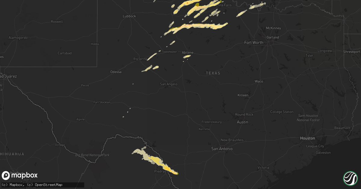
Hail Map in Texas on April 23, 2014
Get this storm
April 23 map
$229
one time, instant access
Download today. No call, no setup
Keep the $229
Bought the map and want the full workflow? Apply the entire $229 to a subscription within 7 days. None of it is wasted.
Every map, not just this one
This buys you this map. Subscription and you get every map we run, in the markets you choose from a few cities to whole states to nationwide. Plus real-time alerts the moment a storm fires.
Contact data
Name, contact info, occupancy, even credit band for addresses in the footprint. You go from where it hit to who to call.
Become the source they trust
Unlimited branding weather history reports on demand. You already have the documented answer ready for the property owner, and you are the one who showed up with it.
Property data and RoofTrace estimates
Pull up any address you have got, its value and the exact code rules for that jurisdiction, straight from One Click Code. Then RoofTrace estimates the squares, pitch, and roof value, priced the way you price.
Storm reports in Texas
Texas
| Date | Description |
|---|---|
| 04/23/20146:45 PM CDT | Downed tree limbs and winds estimated at 70 mph. |
| 04/23/20146:32 PM CDT | Quarter sized hail covering the ground. |
| 04/23/20146:20 PM CDT | A local report indicates 1.75 inch wind near CROWELL |
| 04/23/20146:20 PM CDT | A local report indicates 1.75 inch wind near 2 S CROWELL |
| 04/23/20146:14 PM CDT | A local report indicates 1.50 inch wind near 4 N CHILDRESS |
| 04/23/20146:02 PM CDT | A local report indicates 1.00 inch wind near ASPERMONT |
| 04/23/20146:00 PM CDT | Looked like snow afterwards. Most stones large marble sized...but a few larger. |
| 04/23/20145:00 PM CDT | A local report indicates 1.25 inch wind near MEMPHIS |
| 04/23/20144:55 PM CDT | A local report indicates 60 MPH wind near 10 NE WELLINGTON |
| 04/23/20144:55 PM CDT | A local report indicates 1.50 inch wind near 10 NE WELLINGTON |
| 04/23/20144:41 PM CDT | Quarter size hail continuing |
| 04/23/20144:38 PM CDT | 50 mph winds also reported from this storm |
| 04/23/20144:30 PM CDT | A local report indicates 1.00 inch wind near 13 S TURKEY |
| 04/23/20144:23 PM CDT | Hail three inches deep |
| 04/22/201410:17 PM CDT | A local report indicates 1.00 inch wind near LOVING |
| 04/22/20149:57 PM CDT | A local report indicates 59 MPH wind near 3 ESE ABILENE |
| 04/22/20149:30 PM CDT | Golfball sized hail in fort belknap |
| 04/22/20149:24 PM CDT | A local report indicates 1.00 inch wind near 3 NW NEWCASTLE |
| 04/22/20148:56 PM CDT | A local report indicates 1.50 inch wind near ELBERT |
| 04/22/20148:38 PM CDT | Fm 171 and freeburg church rd |
| 04/22/20148:37 PM CDT | A local report indicates 1.00 inch wind near 1 N SHEPPARD AFB |
| 04/22/20148:28 PM CDT | A local report indicates 1.00 inch wind near 2 N THROCKMORTON |
| 04/22/20148:19 PM CDT | A local report indicates 1.25 inch wind near EAGLE PASS |
| 04/22/20148:14 PM CDT | A local report indicates 1.00 inch wind near 3 N EAGLE PASS |
| 04/22/20148:12 PM CDT | A local report indicates 1.00 inch wind near 2 E IOWA PARK |
| 04/22/20148:08 PM CDT | Time estimated from radar |
| 04/22/20147:55 PM CDT | A local report indicates 1.00 inch wind near 10 NE IRBY |
| 04/22/20147:40 PM CDT | 40 to 50 mph wind gusts also reported. |
| 04/22/20147:38 PM CDT | A local report indicates 1.00 inch wind near OKLAUNION |
| 04/22/20147:25 PM CDT | A local report indicates 1.00 inch wind near WEINERT |
| 04/22/20147:22 PM CDT | A local report indicates 1.25 inch wind near 3 SSE VERNON |
| 04/22/20147:17 PM CDT | Two separate reports. Hail size ranged from quarter to half dollar size with quarter size hail covering the ground. |
| 04/22/20147:15 PM CDT | A local report indicates 76 MPH wind near 1 NW HASKELL |
| 04/22/20147:07 PM CDT | A local report indicates 1.00 inch wind near ROCHESTER |
| 04/22/20147:04 PM CDT | A local report indicates 1.75 inch wind near 4 NE LAKE KEMP |
Cities Impacted by Hail Map on April 23, 2014
- Hollis, OK
- Lone Wolf, OK
- Hobart, OK
- Gotebo, OK
- Roosevelt, OK
- Blair, OK
- Westbrook, TX
- Holliday, TX
- Grinnell, KS
- Memphis, TX
- Wellington, TX
- Kensington, KS
- Albion, NE
- Montezuma, KS
- Childress, TX
- Jermyn, TX
- Jacksboro, TX
- Loving, TX
- Bryson, TX
- Bogue, KS
- Rexford, KS
- Hill City, KS
- Oakley, KS
- Clayton, KS
- Winona, KS
- Selden, KS
- Penokee, KS
- Monument, KS
- Lenora, KS
- Morland, KS
- Hoxie, KS
- Eagle Pass, TX
- Quemado, TX
- Gould, OK
- Quanah, TX
- Goree, TX
- Seymour, TX
- Kearney, NE
- Plains, KS
- Meade, KS
- Grainfield, KS
- Gibbon, NE
- Trumbull, NE
- Harvard, NE
- Crowell, TX
- Paducah, TX
- Oklaunion, TX
- Vernon, TX
- Harrold, TX
- Electra, TX
- Pampa, TX
- Mclean, TX
- Okemah, OK
- Quail, TX
- Sweetwater, TX
- Iowa Park, TX
- Wichita Falls, TX
- Hedley, TX
- Palmer, NE
- Saint Paul, NE
- Ingalls, KS
- Tell, TX
- Norcatur, KS
- Oberlin, KS
- Haskell, TX
- Rule, TX
- Weinert, TX
- Wilcox, NE
- Alma, NE
- Ford, KS
- Bowie, TX
- Montague, TX
- Tupelo, OK
- Stonewall, OK
- Centrahoma, OK
- Turpin, OK
- Matador, TX
- Flomot, TX
- Tuscola, TX
- Turkey, TX
- Mill Creek, OK
- Republican City, NE
- Holdrege, NE
- Stamford, NE
- Orleans, NE
- Graham, TX
- Newcastle, TX
- Doniphan, NE
- Sterling City, TX
- Willow, OK
- Erick, OK
- Dustin, OK
- Saint Jo, TX
- Nocona, TX
- Upland, NE
- Sulphur, OK
- Abilene, TX
- Lelia Lake, TX
- Oxford, NE
- Franklin, NE
- Bloomington, NE
- Hugoton, KS
- Apache, OK
- Carnegie, OK
- Lawton, OK
- Anadarko, OK
- Fort Cobb, OK
- Mountain View, OK
- Shamrock, TX
- Custer City, OK
- Ayr, NE
- Grand Island, NE
- Phillips, NE
- Hastings, NE
- Holstein, NE
- Kenesaw, NE
- Alda, NE
- Riverton, NE
- Aurora, NE
- Minden, NE
- Roseland, NE
- Campbell, NE
- Wood River, NE
- Juniata, NE
- Giltner, NE
- Bladen, NE
- Naponee, NE
- Heartwell, NE
- Belpre, KS
- Throckmorton, TX
- Greensburg, KS
- Butler, OK
- Clinton, OK
- Rocky, OK
- Sentinel, OK
- Chester, OK
- Mooreland, OK
- McCaulley, TX
- Chickasha, OK
- Cement, OK
- Old Glory, TX
- Aspermont, TX
- Norton, KS
- Muenster, TX
- Gainesville, TX
- Coalgate, OK
- Randlett, OK
- Burkburnett, TX
- Devol, OK
- Olney, TX
- Rochester, TX
- Hendley, NE
- Beaver City, NE
- Hildreth, NE
- Almena, KS
- Axtell, NE
- Jayton, TX
- Hampton, NE
- Forgan, OK
- Fowler, KS
- Primrose, NE
- Granite, OK
- Colorado City, TX
- Smith Center, KS
- Wallace, KS
- Marietta, OK
- Sheffield, TX
- Kismet, KS
- Liberal, KS
- Snyder, TX
- Glenvil, NE
- Deweese, NE
- Lawrence, NE
- Blue Hill, NE
- Burneyville, OK
- Garden City, TX
- Allen, KS
- Minneola, KS
- Hope, KS
- Knox City, TX
- Dill City, OK
- Calvin, OK
- Holdenville, OK
- Buffalo Gap, TX
- Mangum, OK
- Ravenna, NE
- Cairo, NE
- Shelton, NE
- Carter, OK
- Park, KS
- Haviland, KS
- Stockton, KS
- Clarendon, TX
- Mullinville, KS
- Cordell, OK
- Big Lake, TX
- Atoka, OK
- Caney, OK
- Sayre, OK
- Wilsonville, NE
- Hooker, OK
- Munday, TX
- Clyde, TX
- Amber, OK
- Pocasset, OK
- Byers, TX
- Petrolia, TX
- Sharon Springs, KS
- Loraine, TX
- Wetumka, OK
- Herington, KS
- Mcalester, OK
- Leon, OK
- Whitesboro, TX
- Taloga, OK
- Hardesty, OK
- Phillipsburg, KS
- Long Island, KS
- Dryden, TX
- Lincolnville, KS
- Tuttle, OK
- Lakeview, TX
- Athol, KS
- Archer City, TX
- Ovalo, TX
- Roby, TX
- Sylvester, TX
- Tishomingo, OK
- Agra, KS
- Lewis, KS
- Henrietta, TX
- Scotland, TX
- Cheyenne, OK
- Wilsey, KS
- Council Grove, KS
- Hammon, OK
- Ada, OK
- Benjamin, TX
- Prairie View, KS
- Carrizo Springs, TX
- Sheppard Afb, TX


