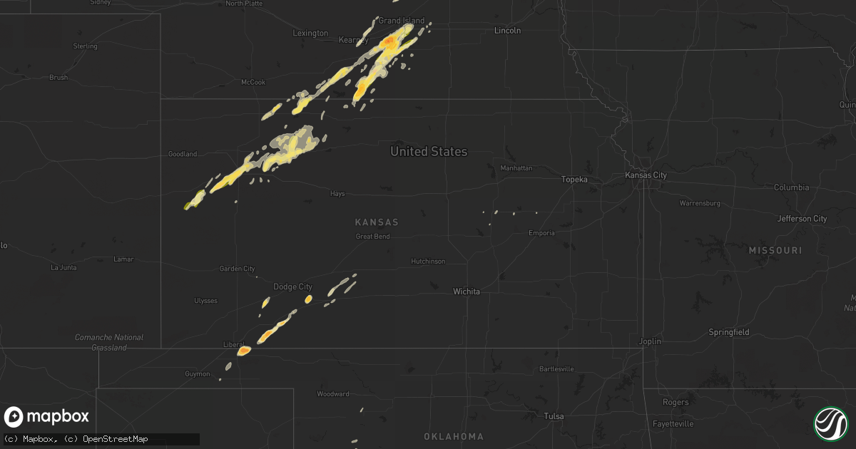
Hail Map in Kansas on April 23, 2014
Get this storm
April 23 map
$229
one time, instant access
Download today. No call, no setup
Keep the $229
Bought the map and want the full workflow? Apply the entire $229 to a subscription within 7 days. None of it is wasted.
Every map, not just this one
This buys you this map. Subscription and you get every map we run, in the markets you choose from a few cities to whole states to nationwide. Plus real-time alerts the moment a storm fires.
Contact data
Name, contact info, occupancy, even credit band for addresses in the footprint. You go from where it hit to who to call.
Become the source they trust
Unlimited branding weather history reports on demand. You already have the documented answer ready for the property owner, and you are the one who showed up with it.
Property data and RoofTrace estimates
Pull up any address you have got, its value and the exact code rules for that jurisdiction, straight from One Click Code. Then RoofTrace estimates the squares, pitch, and roof value, priced the way you price.
Storm reports in Kansas
Kansas
| Date | Description |
|---|---|
| 04/23/20146:49 PM CDT | A local report indicates 60 MPH wind near 10 NNW NORTON |
| 04/23/20146:27 PM CDT | 55 to 60 mph winds at highway 283 and road q about 5 miles south of norton |
| 04/23/20146:20 PM CDT | A local report indicates 1.75 inch wind near 2 WSW MEADE STATE PARK |
| 04/23/20146:15 PM CDT | A local report indicates 1.75 inch wind near 2 S MEADE STATE PARK |
| 04/23/20146:10 PM CDT | The hail lasted only about two minutes. |
| 04/23/20146:03 PM CDT | Hail lasted for 10 minutes then ended. Heavy rain also. Minor street flooding so far. |
| 04/23/20145:58 PM CDT | A local report indicates 1.00 inch wind near 5 NNW THE HAGGARD ELEV |
| 04/23/20145:55 PM CDT | Half inch to quarter size hail with heavy rain and winds estimated at 30 to 40 mph. Ground is starting to become white with accumulating hail. |
| 04/23/20145:46 PM CDT | A local report indicates 1.75 inch wind near 4 E MONTEZUMA |
| 04/23/20145:39 PM CDT | Hail an inch and a half in size southwest of oakley with a lot of pea sized hail. |
| 04/23/20145:34 PM CDT | A local report indicates 1.75 inch wind near 8 SSE HAYNE |
| 04/23/20145:21 PM CDT | Hail was melting fast. Largest stone found was quarter size with the overwhelming majority smaller than quarter size. |
| 04/22/20148:15 PM CDT | A local report indicates 58 MPH wind near 5 WSW GREAT BEND |
| 04/22/20148:14 PM CDT | Westerly gust |
| 04/22/20147:55 PM CDT | Hail lasted about 10 minutes. Most hail was nickel size with some quarter size hail. |
| 04/22/20147:55 PM CDT | A local report indicates 1.50 inch wind near 4 SW FORD |
| 04/22/20147:45 PM CDT | Heavy rain with pea sized hail... Then received quarter size hail for awhile and then pea size hail resumed. |
| 04/22/20147:31 PM CDT | Largest hail was quarter size most hail was smaller |
| 04/22/20147:00 PM CDT | A local report indicates 1.50 inch wind near 1 SSE FOWLER |
Cities Impacted by Hail Map on April 23, 2014
- Hollis, OK
- Lone Wolf, OK
- Hobart, OK
- Gotebo, OK
- Roosevelt, OK
- Blair, OK
- Westbrook, TX
- Holliday, TX
- Grinnell, KS
- Memphis, TX
- Wellington, TX
- Kensington, KS
- Albion, NE
- Montezuma, KS
- Childress, TX
- Jermyn, TX
- Jacksboro, TX
- Loving, TX
- Bryson, TX
- Bogue, KS
- Rexford, KS
- Hill City, KS
- Oakley, KS
- Clayton, KS
- Winona, KS
- Selden, KS
- Penokee, KS
- Monument, KS
- Lenora, KS
- Morland, KS
- Hoxie, KS
- Eagle Pass, TX
- Quemado, TX
- Gould, OK
- Quanah, TX
- Goree, TX
- Seymour, TX
- Kearney, NE
- Plains, KS
- Meade, KS
- Grainfield, KS
- Gibbon, NE
- Trumbull, NE
- Harvard, NE
- Crowell, TX
- Paducah, TX
- Oklaunion, TX
- Vernon, TX
- Harrold, TX
- Electra, TX
- Pampa, TX
- Mclean, TX
- Okemah, OK
- Quail, TX
- Sweetwater, TX
- Iowa Park, TX
- Wichita Falls, TX
- Hedley, TX
- Palmer, NE
- Saint Paul, NE
- Ingalls, KS
- Tell, TX
- Norcatur, KS
- Oberlin, KS
- Haskell, TX
- Rule, TX
- Weinert, TX
- Wilcox, NE
- Alma, NE
- Ford, KS
- Bowie, TX
- Montague, TX
- Tupelo, OK
- Stonewall, OK
- Centrahoma, OK
- Turpin, OK
- Matador, TX
- Flomot, TX
- Tuscola, TX
- Turkey, TX
- Mill Creek, OK
- Republican City, NE
- Holdrege, NE
- Stamford, NE
- Orleans, NE
- Graham, TX
- Newcastle, TX
- Doniphan, NE
- Sterling City, TX
- Willow, OK
- Erick, OK
- Dustin, OK
- Saint Jo, TX
- Nocona, TX
- Upland, NE
- Sulphur, OK
- Abilene, TX
- Lelia Lake, TX
- Oxford, NE
- Franklin, NE
- Bloomington, NE
- Hugoton, KS
- Apache, OK
- Carnegie, OK
- Lawton, OK
- Anadarko, OK
- Fort Cobb, OK
- Mountain View, OK
- Shamrock, TX
- Custer City, OK
- Ayr, NE
- Grand Island, NE
- Phillips, NE
- Hastings, NE
- Holstein, NE
- Kenesaw, NE
- Alda, NE
- Riverton, NE
- Aurora, NE
- Minden, NE
- Roseland, NE
- Campbell, NE
- Wood River, NE
- Juniata, NE
- Giltner, NE
- Bladen, NE
- Naponee, NE
- Heartwell, NE
- Belpre, KS
- Throckmorton, TX
- Greensburg, KS
- Butler, OK
- Clinton, OK
- Rocky, OK
- Sentinel, OK
- Chester, OK
- Mooreland, OK
- McCaulley, TX
- Chickasha, OK
- Cement, OK
- Old Glory, TX
- Aspermont, TX
- Norton, KS
- Muenster, TX
- Gainesville, TX
- Coalgate, OK
- Randlett, OK
- Burkburnett, TX
- Devol, OK
- Olney, TX
- Rochester, TX
- Hendley, NE
- Beaver City, NE
- Hildreth, NE
- Almena, KS
- Axtell, NE
- Jayton, TX
- Hampton, NE
- Forgan, OK
- Fowler, KS
- Primrose, NE
- Granite, OK
- Colorado City, TX
- Smith Center, KS
- Wallace, KS
- Marietta, OK
- Sheffield, TX
- Kismet, KS
- Liberal, KS
- Snyder, TX
- Glenvil, NE
- Deweese, NE
- Lawrence, NE
- Blue Hill, NE
- Burneyville, OK
- Garden City, TX
- Allen, KS
- Minneola, KS
- Hope, KS
- Knox City, TX
- Dill City, OK
- Calvin, OK
- Holdenville, OK
- Buffalo Gap, TX
- Mangum, OK
- Ravenna, NE
- Cairo, NE
- Shelton, NE
- Carter, OK
- Park, KS
- Haviland, KS
- Stockton, KS
- Clarendon, TX
- Mullinville, KS
- Cordell, OK
- Big Lake, TX
- Atoka, OK
- Caney, OK
- Sayre, OK
- Wilsonville, NE
- Hooker, OK
- Munday, TX
- Clyde, TX
- Amber, OK
- Pocasset, OK
- Byers, TX
- Petrolia, TX
- Sharon Springs, KS
- Loraine, TX
- Wetumka, OK
- Herington, KS
- Mcalester, OK
- Leon, OK
- Whitesboro, TX
- Taloga, OK
- Hardesty, OK
- Phillipsburg, KS
- Long Island, KS
- Dryden, TX
- Lincolnville, KS
- Tuttle, OK
- Lakeview, TX
- Athol, KS
- Archer City, TX
- Ovalo, TX
- Roby, TX
- Sylvester, TX
- Tishomingo, OK
- Agra, KS
- Lewis, KS
- Henrietta, TX
- Scotland, TX
- Cheyenne, OK
- Wilsey, KS
- Council Grove, KS
- Hammon, OK
- Ada, OK
- Benjamin, TX
- Prairie View, KS
- Carrizo Springs, TX
- Sheppard Afb, TX


