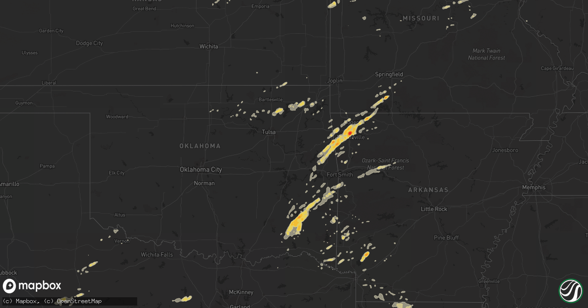
Hail Map on April 21, 2011
Get this storm
April 21 map
$229
one time, instant access
Download today. No call, no setup
Keep the $229
Bought the map and want the full workflow? Apply the entire $229 to a subscription within 7 days. None of it is wasted.
Every map, not just this one
This buys you this map. Subscription and you get every map we run, in the markets you choose from a few cities to whole states to nationwide. Plus real-time alerts the moment a storm fires.
Contact data
Name, contact info, occupancy, even credit band for addresses in the footprint. You go from where it hit to who to call.
Become the source they trust
Unlimited branding weather history reports on demand. You already have the documented answer ready for the property owner, and you are the one who showed up with it.
Property data and RoofTrace estimates
Pull up any address you have got, its value and the exact code rules for that jurisdiction, straight from One Click Code. Then RoofTrace estimates the squares, pitch, and roof value, priced the way you price.
States Impacted by Hail Map on April 21, 2011
Storm reports
Missouri
| Date | Description |
|---|---|
| 04/21/20114:23 PM CDT | A local report indicates 1.00 inch wind near 1 SW BRUNER |
| 04/21/20113:35 PM CDT | A local report indicates 1.75 inch wind near 1 N REEDS SPRING |
| 04/21/20115:50 AM CDT | A local report indicates 1.00 inch wind near LIBERTY |
Alabama
| Date | Description |
|---|---|
| 04/21/20113:47 PM CDT | Storm spotter reported 60 mph in needham. |
| 04/21/20112:36 PM CDT | Top of a tree blown onto us highway 11 just north of york. |
Texas
| Date | Description |
|---|---|
| 04/21/20116:59 PM CDT | Hail ranging dimes up to the size of golfballs fell from 645pm to 715 pm. |
| 04/21/20116:04 PM CDT | 50 knot wind gust measured at dryden asos. |
| 04/21/20114:20 PM CDT | Reported along highway 285. |
| 04/21/20111:44 PM CDT | Cocorahs report indicated ping pong size hail |
| 04/20/201111:44 PM CDT | Quarter size hail reported by border patrol. |
| 04/20/201111:00 PM CDT | Quarter size hail in boonsville |
| 04/20/201110:21 PM CDT | A local report indicates 1.00 inch wind near CHILLICOTHE |
| 04/20/20118:19 PM CDT | Hail from goflball to hen egg size 7 miles north of trent |
| 04/20/20118:10 PM CDT | Ping pong ball size hail in rotan |
Mississippi
| Date | Description |
|---|---|
| 04/21/20112:15 PM CDT | A local report indicates 1.00 inch wind near TOOMSUBA |
| 04/21/20111:49 PM CDT | Several trees down...one of which fell across blind brown road. Also...several reports of 50 mph winds in the northwest part of the county |
| 04/21/20111:31 PM CDT | Trees down across ms highway 494. |
| 04/21/20111:29 PM CDT | Multiple trees downed across chunky-duffee rd |
| 04/21/20111:28 PM CDT | Multiple trees down across hickory nut rd and hopewell rd |
| 04/21/20111:26 PM CDT | Trees were downed along blackwell rd and hickory little rock rd. |
| 04/21/201112:10 PM CDT | A local report indicates 1.00 inch wind near GALLMAN |
| 04/21/20117:56 AM CDT | Golfball hail reportedly broke some windows. |
| 04/21/20117:49 AM CDT | Golfball hail reported in the eagle bend area. |
| 04/21/20117:48 AM CDT | Observed while traveling on highway 49 |
Idaho
| Date | Description |
|---|---|
| 04/21/20111:50 PM CDT | A local report indicates 64 MPH wind near ATOMIC CITY |
| 04/21/20111:50 PM CDT | A local report indicates 58 MPH wind near 10 SSW SOUTHWEST INL |
| 04/21/20111:47 PM CDT | A local report indicates 63 MPH wind near 17 W ABERDEEN |
Oklahoma
| Date | Description |
|---|---|
| 04/21/20115:30 PM CDT | Nickel and quarter size hail reported at auto dealership on south end of town. |
| 04/21/20114:00 PM CDT | A local report indicates 1.00 inch wind near FANSHAWE |
| 04/21/20113:12 PM CDT | A local report indicates 1.75 inch wind near WESTVILLE |
| 04/21/20113:10 PM CDT | Lot of damage to asphalt shingles. |
| 04/21/20113:02 PM CDT | Lots of small hail with quarter being the largest |
| 04/21/20112:52 PM CDT | A local report indicates 1.75 inch wind near CLAYTON |
| 04/21/20111:12 PM CDT | A local report indicates 1.75 inch wind near 2 N SNOW |
| 04/21/201112:41 PM CDT | A local report indicates 1.00 inch wind near BUNCH |
| 04/21/20118:50 AM CDT | Truck driver at a convenience store relayed that he went through hail that was quarter-sized. |
Wyoming
| Date | Description |
|---|---|
| 04/21/20113:31 PM CDT | A local report indicates 61 MPH wind near 13 E EVANSTON |
| 04/21/20113:20 PM CDT | A local report indicates 71 MPH wind near EVANSTON |
Utah
| Date | Description |
|---|---|
| 04/21/20113:02 PM CDT | Semi truck blown over |
| 04/21/20112:30 PM CDT | Odgen peak - ogp 9570 ft |
| 04/21/20112:30 PM CDT | At least two dozen large trees down in huntsville. Several of the down trees damaged structures with one house with moderate damage. Many powerlines down. |
| 04/21/20112:30 PM CDT | 18-24 inch diameter tree snapped and landed on house causing minor roof damage in the avenues |
| 04/21/20112:26 PM CDT | A parked small privately owned air plane was flipped over by the strong winds at the bountiful airport. |
| 04/21/20112:25 PM CDT | Large trees down in rose park |
| 04/21/20112:24 PM CDT | A local report indicates 61 MPH wind near 9 SW LEHI |
| 04/21/20112:20 PM CDT | Multiple trees down in the ogden area. |
| 04/21/20112:20 PM CDT | Baccus sensor |
| 04/21/20112:20 PM CDT | Multiple trees down. Powerlines reported down across the county. |
| 04/21/20112:15 PM CDT | Light pole fell on 2 cars at salt lake international airport |
| 04/21/20112:15 PM CDT | Ditto |
| 04/21/20112:15 PM CDT | Vernon hill sensor |
| 04/21/20112:14 PM CDT | Salt lake city airport sensor |
| 04/21/20112:10 PM CDT | Trees down in tremonton. Windows blown out in vehicles. |
| 04/21/20112:05 PM CDT | Lake point sensor |
| 04/21/20111:50 PM CDT | White sage sensor |
| 04/21/20111:45 PM CDT | English village sensor |
| 04/21/20111:45 PM CDT | Baker lab sensor |
| 04/21/20111:45 PM CDT | Simpson springs dugway |
| 04/21/20111:45 PM CDT | Camel back mountain |
| 04/21/20111:35 PM CDT | Tower grid sensor |
| 04/21/20111:35 PM CDT | Nw decon pad dugway sensor |
| 04/21/20111:33 PM CDT | Fish springs sensor |
| 04/21/20111:33 PM CDT | Uttr sensor |
| 04/21/20111:33 PM CDT | I80 at grassey sensor |
| 04/21/20111:33 PM CDT | Camel back mountain station |
| 04/21/20111:30 PM CDT | Gunnison island sensor |
| 04/21/20111:30 PM CDT | Lakeside mountain sensor |
| 04/21/20111:30 PM CDT | Snowbasin sensor |
| 04/21/20111:10 PM CDT | Upper cedar mountain sensor |
| 04/21/20111:10 PM CDT | Playa station sensor |
| 04/21/201112:50 PM CDT | Diddle knoll sensor |
| 04/21/201112:15 PM CDT | Wendover peak sensor |
| 04/21/201112:00 PM CDT | I-80 mp 1 sensor |
Louisiana
| Date | Description |
|---|---|
| 04/21/20112:51 PM CDT | Hail falling heavy at times at the fire station on highway 37. |
| 04/21/20119:01 AM CDT | A local report indicates 1.00 inch wind near LISBON |
| 04/21/20118:48 AM CDT | Several trees down on richardson loop near hwy 9. Some trees are blocking the road. |
| 04/21/20118:47 AM CDT | Tree down at hwy 9 and forest grove rd. |
Arkansas
| Date | Description |
|---|---|
| 04/21/20113:00 PM CDT | A local report indicates 1.75 inch wind near 8 NW OZAN |
| 04/21/20112:47 PM CDT | Lots of pea and nickel but some as large as a quarter. |
| 04/21/20112:35 PM CDT | A local report indicates 1.75 inch wind near 5 WNW EUREKA SPRINGS |
| 04/21/20112:26 PM CDT | A local report indicates 1.00 inch wind near ROGERS |
| 04/21/20112:05 PM CDT | Photo of the hail showed its diameter was almost the width of two nickels. |
| 04/21/20112:05 PM CDT | Quarter sized and larger hail causing cars to slide off the road on 540 near mile marker 67. |
| 04/21/20112:04 PM CDT | A local report indicates 1.75 inch wind near SPRINGDALE |
| 04/21/20112:00 PM CDT | Reported at johnson exit on i-540. Also report of broken windows of parked cars at bank in johnson. |
| 04/21/20112:00 PM CDT | Reported on the west side of town. Relayed via broadcast media. Hail was measured with calipers. |
| 04/21/20111:55 PM CDT | A local report indicates 1.00 inch wind near 1 S SILOAM SPRINGS |
| 04/21/20111:55 PM CDT | On mt comfort road northwest of fayetteville |
| 04/21/20111:27 PM CDT | A local report indicates 1.75 inch wind near LINCOLN |
Kansas
| Date | Description |
|---|---|
| 04/21/20115:10 AM CDT | A local report indicates 1.00 inch wind near BASEHOR |
| 04/21/20114:54 AM CDT | A local report indicates 1.00 inch wind near 3 S MCLOUTH |
| 04/21/20114:25 AM CDT | A few quarters but mostly penny to nickel sized hail. Time estimated. |
| 04/21/20113:59 AM CDT | A local report indicates 1.00 inch wind near BURLINGAME |
Colorado
| Date | Description |
|---|---|
| 04/20/201110:15 PM CDT | Greeley airport |
South Carolina
| Date | Description |
|---|---|
| 04/21/20115:40 PM CDT | Quarter to half dollar size hail reported along bears bluff rd. |
| 04/21/20114:40 PM CDT | Quarter sized hail reported at johnson hagood stadium. |
| 04/21/20114:31 PM CDT | Quarter sized hail reported along foster street. |
| 04/21/20114:30 PM CDT | Quarter size hail reported at the ashley hall plantation subdivision in west ashley |
| 04/21/20114:30 PM CDT | Golf ball sized hail reported along raul wallenberg blvd. |
| 04/21/20114:30 PM CDT | The public reported quarter size hail at the village square. Several cars had light to moderate hail damage. |
| 04/21/20114:25 PM CDT | Quarter sized hail reported along bayhill drive. |
| 04/21/20114:25 PM CDT | Golf ball size hail reported near 61 and wallenberg drive in west ashley |
| 04/21/20114:22 PM CDT | Golf ball size hail reported at the grand oaks subdivision in west ashley |
| 04/21/20114:20 PM CDT | Quarter sized hail reported along glen oaks court. |
| 04/21/20114:02 PM CDT | A local report indicates 1.50 inch wind near 3 SE SUMMERVILLE |
| 04/21/20114:00 PM CDT | Quarter sized hail reported in cane bay plantation. |
| 04/21/20113:55 PM CDT | A local report indicates 1.00 inch wind near 2 S SUMMERVILLE |
| 04/21/20113:52 PM CDT | A local report indicates 1.00 inch wind near 6 NNE JEDBURG |
Georgia
| Date | Description |
|---|---|
| 04/21/20116:15 PM CDT | Hail to ping pong ball size reported along charlies rd near rabbit hill. |
| 04/21/20116:10 PM CDT | Penny to quarter size hail located along hwy 144 near rabbit hill. |
| 04/21/20115:45 PM CDT | The public reported quarter size hail that lasted for 15 minutes. The hail covered the ground and knocked down a lot of tree limbs. |
| 04/21/20115:01 PM CDT | The public reported golf ball size hail lasting 3 minutes. |
| 04/21/20114:45 PM CDT | Golf ball size hail reported in everett. |
Cities Impacted by Hail Map on April 21, 2011
- Dwight, KS
- Alta Vista, KS
- Junction City, KS
- Round Mountain, TX
- Llano, TX
- Stilwell, OK
- Bunch, OK
- Eskridge, KS
- Braymer, MO
- Kansas City, MO
- Chelsea, OK
- Mena, AR
- Marble Falls, TX
- Burnet, TX
- Tescott, KS
- Edisto Island, SC
- Hollywood, SC
- Dryden, TX
- Charleston, SC
- Antlers, OK
- Carrollton, MO
- Norborne, MO
- Eldorado, TX
- Sonora, TX
- Athens, LA
- Homer, LA
- Barnsdall, OK
- Mccurtain, OK
- Woodbine, KS
- Herington, KS
- Hope, KS
- Umpire, AR
- Wickes, AR
- Grannis, AR
- Gillham, AR
- Poteau, OK
- Stigler, OK
- Kinta, OK
- Johns Island, SC
- Wadmalaw Island, SC
- Yazoo City, MS
- Galena, MO
- Rapid City, SD
- Fayetteville, AR
- Springdale, AR
- Orrick, MO
- Broken Bow, OK
- Eagletown, OK
- Ashdown, AR
- Foreman, AR
- Ozona, TX
- Bentonia, MS
- Benton, MS
- Lawrence, KS
- Lecompton, KS
- Roby, TX
- Sylvester, TX
- Sweetwater, TX
- Merkel, TX
- La Plata, MO
- Lincoln, AR
- Menard, TX
- Bentonville, AR
- Raymore, MO
- Belton, MO
- Haynesville, LA
- Midway, GA
- Riceboro, GA
- Summers, AR
- Garfield, AR
- Cookson, OK
- Farmington, AR
- Eureka Springs, AR
- Rogers, AR
- Golden, MO
- Prairie Grove, AR
- Berryville, AR
- Vian, OK
- Welling, OK
- Sallisaw, OK
- Shell Knob, MO
- Westville, OK
- Canehill, AR
- Lowell, AR
- Kansas City, KS
- Leavenworth, KS
- Tonganoxie, KS
- Bonner Springs, KS
- Basehor, KS
- Waldron, MO
- Dickens, NE
- Wellfleet, NE
- Del Rio, TX
- Rocksprings, TX
- Charleston Afb, SC
- North Charleston, SC
- Summerville, SC
- Ladson, SC
- Magnolia, AR
- Huger, SC
- Goose Creek, SC
- Freeburg, MO
- Richton, MS
- Waynesboro, MS
- Hazlehurst, MS
- Crystal Springs, MS
- Colorado City, TX
- Westbrook, TX
- Jacksonboro, SC
- Green Pond, SC
- Round O, SC
- Adams Run, SC
- Ocilla, GA
- Walterboro, SC
- Winslow, AR
- Creighton, MO
- Fitzgerald, GA
- Nahunta, GA
- Folkston, GA
- Rattan, OK
- Snow, OK
- Nashoba, OK
- Clayton, OK
- Finley, OK
- Vaughan, MS
- Lexington, NE
- Hermann, MO
- Linn, MO
- Chamois, MO
- Morrison, MO
- Berger, MO
- Mount Sterling, MO
- Smithville, OK
- Fort Stockton, TX
- Richmond Hill, GA
- Thomasville, AL
- Townsend, GA
- Darien, GA
- Brunswick, GA
- Hawley, TX
- Lockesburg, AR
- Talala, OK
- Eucha, OK
- Isle Of Palms, SC
- Mount Pleasant, SC
- Tallulah, LA
- Holden, MO
- Centerview, MO
- Fairfax, OK
- Ralston, OK
- Hodgen, OK
- Vicksburg, MS
- Murfreesboro, AR
- Bella Vista, AR
- Pineville, MO
- Waldron, AR
- Heavener, OK
- Owensville, MO
- Bland, MO
- Dawson, NE
- Perrin, TX
- Poolville, TX
- Bridgeport, TX
- Paradise, TX
- Springtown, TX
- Afton, OK
- Beaufort, SC
- Emerson, AR
- Berryton, KS
- De Queen, AR
- Norman, AR
- Wheeling, MO
- Meadville, MO
- Lincolnville, KS
- Sullivans Island, SC
- Dorchester, SC
- Council Grove, KS
- Wilsey, KS
- Quanah, TX
- Smithville, MO
- Ramona, OK
- Mineral Springs, AR
- Nashville, AR
- Saratoga, AR
- Ozan, AR
- Vinita, OK
- Sontag, MS
- Wesson, MS
- Monticello, MS
- Georgetown, SC
- Reeds Spring, MO
- Cape Fair, MO
- Ridgeland, SC
- Coosawhatchie, SC
- Higginsville, MO
- Mayview, MO
- Easton, MO
- Linneus, MO
- Oskaloosa, KS
- Reading, KS
- Clarksville, AR
- Chester, AR
- Cedarville, AR
- Rudy, AR
- Richmond, MO
- Jayess, MS
- New Cambria, MO
- Anson, TX
- Arcadia, LA
- Minden, LA
- Savannah, GA
- Jay, OK
- Gypsum, KS
- Abilene, KS
- Watts, OK
- Topeka, KS
- Summerfield, LA
- Bernice, LA
- Lost Springs, KS
- Comstock, TX
- Rotan, TX
- Buckner, AR
- Stamps, AR
- Drexel, MO
- Adrian, MO
- Westphalia, MO
- Koeltztown, MO
- Sibley, MO
- Camden, MO
- Hardin, MO
- Henrietta, MO
- Greensburg, LA
- Amite, LA
- Talihina, OK
- Wister, OK
- Amsterdam, MO
- Mountainburg, AR
- Fairfax, MO
- Snyder, TX
- Jayton, TX
- Lisbon, LA
- Dubach, LA
- Nemaha, NE
- Cove, AR
- Wetmore, KS
- Powhattan, KS
- Netawaka, KS
- Chula, GA
- Fleming, CO
- Greenwood, AR
- Hackett, AR
- Fort Smith, AR
- Cameron, OK
- Pinopolis, SC
- Grove, OK
- Lansing, KS
- McLouth, KS
- Perry, KS
- Shawnee, KS
- Wakarusa, KS
- Platte City, MO
- Alma, KS
- Paxico, KS
- Maple Hill, KS
- White City, KS
- Allen, KS
- Carbondale, KS
- Linwood, KS
- Tecumseh, KS
- Overbrook, KS
- Auburn, KS
- Harveyville, KS
- Lees Summit, MO
- Bradley, AR
- Taylor, AR
- Texarkana, AR
- Sparta, MO
- Ozark, MO
- Kingsville, MO
- Salisbury, MO
- Hartshorne, OK
- Wilburton, OK
- Hazlehurst, GA
- Tarkio, MO
- White Oak, GA
- Ridgeville, SC
- Harleyville, SC
- Chillicothe, TX
- Shady Point, OK
- Bokoshe, OK
- Howe, OK
- Prairie Du Rocher, IL
- Waynesville, GA
- Hortense, GA
- Liberty, MO
- Garland City, AR
- Natural Dam, AR
- West Fork, AR
- Brady, NE
- Moorefield, NE
- Maxwell, NE
- Proctor, OK
- Prescott, AR
- Dixon, MO
- Sylvan Grove, KS
- Lincoln, KS
- Oologah, OK
- Vera, OK
- Collinsville, OK
- Marion, KS
- Tampa, KS
- Durham, KS
- Hillsboro, KS
- Rolla, MO
- Briggs, TX
- Fort Hood, TX
- Kempner, TX
- Copperas Cove, TX
- Killeen, TX
- Burlingame, KS
- Osage City, KS
- Mayersville, MS
- Sondheimer, LA
- Vienna, MO
- Manhattan, KS
- Dawn, MO
- Cowgill, MO
- Ellsworth, KS
- Utica, MS
- Saint Simons Island, GA
- Ozark, AR
- Bates City, MO
- Oak Grove, MO
- London, TX
- Lake Providence, LA
- Pioneer, LA
- Lamar, AR
- Hagarville, AR
- Salem, NE
- Verdon, NE
- Elmer, MO
- Ethel, MO
- Brookville, KS
- Keota, OK
- Hominy, OK
- Seymour, TX
- Lenexa, KS
- Junction, TX
- Osceola, MO
- Quincy, MO
- Canton, MS
- Redwood, MS
- Columbia, MS
- Sumrall, MS
- Siloam Springs, AR
- Gentry, AR
- Appleton City, MO
- Deepwater, MO
- Ira, TX
- Butler, AL
- Wann, OK
- Madison, MS
- Highlandville, MO
- Tuskahoma, OK
- Maysville, MO
- Amity, MO
- Watson, OK
- Marionville, MO
- Climax Springs, MO
- Edwards, MO
- Marland, OK
- Haxtun, CO
- Huntington, AR
- Hermleigh, TX
- McCaulley, TX
- Archie, MO
- Odessa, MO
- Vandervoort, AR
- Haworth, OK
- Hayes Center, NE
- Ramona, KS
- Rosebud, MO
- Cuba, MO
- Sullivan, MO
- Roseland, LA
- Bogard, MO
- Tina, MO
- Colcord, OK
- Valley Park, MS
- Junction City, AR
- Charleston, AR
- Branch, AR
- Ratcliff, AR
- Yemassee, SC
- Saint Joseph, MO
- Americus, KS
- Emporia, KS
- Altus, AR
- Paris, AR
- Hartman, AR
- Coal Hill, AR
- Excelsior Springs, MO
- Lewisville, AR
- Big Cabin, OK
- Levasy, MO
- Independence, MO
- Rayville, MO
- Buckner, MO
- Blue Springs, MO
- Vernon, TX
- Rolling Fork, MS
- Dierks, AR
- Arkadelphia, AR
- Ludowici, GA
- Hatfield, AR
- Old Glory, TX
- Aspermont, TX
- Crane, MO
- Concordia, MO
- Fulton, AR
- Bluejacket, OK
- Horatio, AR
- Wamego, KS
- Coffeyville, KS
- Huntsville, AR
- Red Oak, OK
- Ruth, MS
- Decatur, MS
- Pine Grove, LA
- Clinton, LA
- Hardeeville, SC
- Moncks Corner, SC
- Harrisonville, MO
- Lawson, MO
- Chapman, KS
- Rogersville, MO
- East Carbon, UT
- Hiawatha, KS
- Robinson, KS
- Kanopolis, KS
- Riley, KS
- Fort Riley, KS
- Ogden, KS
- Hamer, ID
- Nowata, OK
- Corning, KS
- La Cygne, KS
- Aurora, MO
- Bern, KS
- Humboldt, NE
- Horseshoe Bay, TX
- Fredericksburg, TX
- Willow City, TX
- Stanberry, MO
- Meridian, MS
- S Coffeyville, OK
- Idabel, OK
- Paducah, TX
- Shongaloo, LA
- Wallace, NE
- Bosworth, MO
- Red Rock, OK
- Seabrook, SC
- Beverly, KS
- Hindsville, AR
- Satartia, MS
- Sanderson, TX
- Silver Creek, MS
- Albion, OK
- Hugo, OK
- Centerton, AR
- Billings, MO
- Clever, MO
- Waverly, MO
- Atlanta, MO
- Kearney, MO
- Tinsley, MS
- Seligman, MO
- Eagle Rock, MO
- Salina, KS
- Evansville, AR
- Fairland, OK
- Wyandotte, OK
- Avery, TX
- Clarksville, TX
- Kentwood, LA
- Denham Springs, LA
- Flora, MS
- Enterprise, KS
- Elkins, AR
- Malta Bend, MO
- Roxie, MS
- Boswell, OK
- Soper, OK
- Fouke, AR
- Weaubleau, MO
- Pittsburg, OK
- New Boston, MO
- Brookfield, MO
- Gothenburg, NE
- Cozad, NE
- Corder, MO
- Alma, MO
- Paxton, NE
- Cassville, MO
- Winchester, KS
- Easton, KS
- Hope, AR
- Warrensburg, MO
- State Line, MS
- Ruffin, SC
- Kingsland, TX
- Missouri City, MO
- Lampasas, TX
- Wathena, KS
- Rushville, MO
- Barnard, MO
- Graham, MO
- Winthrop, AR
- Wynona, OK
- Culbertson, NE
- New Cambria, KS
- Inkom, ID
- Maysville, AR
- Bennington, KS
- Pawhuska, OK
- Ruston, LA
- Abilene, TX
- Blairstown, MO
- Solomon, KS
- Odell, TX