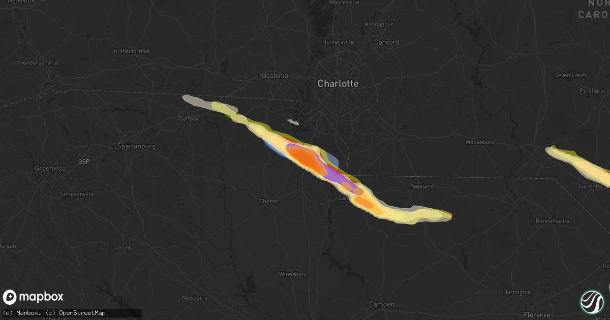
Hail Map in Rock Hill, SC on April 20, 2024
Get this storm
April 20 map
$229
one time, instant access
Download today. No call, no setup
Keep the $229
Bought the map and want the full workflow? Apply the entire $229 to a subscription within 7 days. None of it is wasted.
Every map, not just this one
This buys you this map. Subscription and you get every map we run, in the markets you choose from a few cities to whole states to nationwide. Plus real-time alerts the moment a storm fires.
Contact data
Name, contact info, occupancy, even credit band for addresses in the footprint. You go from where it hit to who to call.
Become the source they trust
Unlimited branding weather history reports on demand. You already have the documented answer ready for the property owner, and you are the one who showed up with it.
Property data and RoofTrace estimates
Pull up any address you have got, its value and the exact code rules for that jurisdiction, straight from One Click Code. Then RoofTrace estimates the squares, pitch, and roof value, priced the way you price.
Storm reports in Rock Hill, SC
Rock Hill, SC
| Date | Description |
|---|---|
| 04/20/20243:35 PM CDT | A local report indicates 1.00 inch wind near 3 W Catawba |
| 04/20/20243:30 PM CDT | A local report indicates 2.00 inch wind near 1 SSE Rock Hill |
| 04/20/20243:30 PM CDT | A local report indicates 1.50 inch wind near 1 SSE Rock Hill |
| 04/20/20243:30 PM CDT | A local report indicates 1.00 inch wind near 4 NW Catawba |
| 04/20/20243:25 PM CDT | Two 100 ft towers destroyed. Large trees snapped. |
| 04/20/20243:25 PM CDT | Trees blocking roadway. |
| 04/20/20243:25 PM CDT | Corrects previous tstm wnd dmg report from 3 ne mcconnells. Considerable tree damage along mcconnells highway. Several large trees fell on the highway. |
| 04/20/20243:21 PM CDT | Multiple sources report widespread tree damage throughout rock hill... With some trees down on structures. The awning of a gas station was also collapsed. Damage is mos |
| 04/20/20243:21 PM CDT | Public reported softball size hail near the intersection of highway 901 and saluda st in rock hill. Widespread hail damage reported throughout the city. |
| 04/20/20243:20 PM CDT | Several large downed trees on madeline dr. |
| 04/20/20243:15 PM CDT | A local report indicates 1.00 inch wind near 6 W Rock Hill |
All States Impacted by Hail Map on April 20, 2024
All Cities Impacted by Hail Map on April 20, 2024
- Sanger, TX
- Aubrey, TX
- Valley View, TX
- Pilot Point, TX
- Gunter, TX
- Tioga, TX
- Celina, TX
- Delhi, LA
- Midlothian, TX
- Stanton, TX
- Tallulah, LA
- Waxahachie, TX
- Robert Lee, TX
- Newellton, LA
- Big Spring, TX
- Coahoma, TX
- Vicksburg, MS
- Welch, TX
- Wingate, TX
- Winters, TX
- Hobbs, NM
- Lamesa, TX
- Naples, TX
- Anson, TX
- Doddridge, AR
- Post, TX
- Tuscola, TX
- Merkel, TX
- Hamlin, TX
- Abilene, TX
- Buffalo Gap, TX
- Sweetwater, TX
- Pyote, TX
- Barstow, TX
- Tye, TX
- Clyde, TX
- Ovalo, TX
- Goldsboro, TX
- Baird, TX
- Lawn, TX
- Honoraville, AL
- Greenville, AL
- Luverne, AL
- Highland Home, AL
- Gaffney, SC
- Mooresboro, NC
- Blacksburg, SC
- Grady, AL
- Lapine, AL
- Clover, SC
- York, SC
- Rockingham, NC
- Hamlet, NC
- Marston, NC
- Mount Gilead, NC
- Smyrna, SC
- Goshen, AL
- Laurel Hill, NC
- New London, NC
- Troy, NC
- Rock Hill, SC
- Laurinburg, NC
- Candor, NC
- Canton, MS
- Madison, MS
- Maxton, NC
- Wagram, NC
- Biscoe, NC
- Star, NC
- Catawba, SC
- Lancaster, SC
- Red Springs, NC
- Pembroke, NC
- Bellville, TX
- Edgemoor, SC
- Norwood, NC
- Ellerbe, NC
- Shelby, NC
- Waxhaw, NC
- Lumberton, NC
- Fortson, GA
- Hamilton, GA
- Mullin, TX
- Fayetteville, NC
- Heath Springs, SC
- Hempstead, TX
- Cataula, GA
- Rochelle, GA
- Rebecca, GA
- Kershaw, SC
- Hope Mills, NC
- Fitzgerald, GA
- Jefferson, SC
- Pageland, SC
- Mount Croghan, SC
- Evergreen, NC
- Bladenboro, NC
- Bethune, SC
- Andrews, TX
- Fitzpatrick, AL
- Culloden, GA
- Kentwood, LA
- Whiteville, NC
- Clarkton, NC
- McBee, SC
- Greensburg, LA
- Grover, NC
- Chadbourn, NC
- Clarendon, NC
- Hardaway, AL
- Hartsville, SC
- Winnabow, NC
- Leland, NC
- McColl, SC
- Patrick, SC
- Roseland, LA
- Lumberton, MS
- Hallsboro, NC
- Mount Vernon, AL
- Montgomery, AL
- Lizella, GA
- Society Hill, SC
- Shannon, NC
- Atmore, AL
- Copperas Cove, TX
- Kempner, TX
- Ash, NC
- Pike Road, AL
- Mathews, AL
- Fort Hood, TX
- Macon, GA
- West Point, GA
- Nakina, NC
- Lake Waccamaw, NC
- Ovett, MS
- Rowland, NC
- Darlington, SC
- Richton, MS
- Laurel, MS
- Cecil, AL
- Sandersville, GA
- Supply, NC
- Bolivia, NC
- Waynesboro, MS
- Dillon, SC
- Latta, SC
- Milledgeville, GA
- Frisco City, AL
- Brewton, AL
- Marion, SC
- Buckatunna, MS
- State Line, MS
- Fork, SC
- Mullins, SC
- Ledbetter, TX
- Barksdale, TX
- Nichols, SC
- Warthen, GA
- Davisboro, GA
- Carmine, TX
- Rocksprings, TX
- Castleberry, AL
- Southport, NC
- Junction, TX
- Oak Island, NC
- Loris, SC
- Green Sea, SC
- Fruitdale, AL
- Chatom, AL
- Galivants Ferry, SC
- Camp Wood, TX
- Leakey, TX
- Deer Park, AL
- Aynor, SC
- Louisville, GA
- Avera, GA
- Longs, SC
- Tabor City, NC
- Conway, SC
- Little River, SC
- Rio Frio, TX
- Blenheim, SC
- McKenzie, AL
- Evergreen, AL
- Georgiana, AL
- Franklin, AL
- Whatley, AL
- Bolton, NC
- Cotulla, TX
- Forest Home, AL
- Myrtle Beach, SC
- Pine Apple, AL
- Encinal, TX
- Cerro Gordo, NC
- D Hanis, TX
- Hondo, TX
- Fort Deposit, AL
- Letohatchee, AL
- Hope Hull, AL
- Hayneville, AL
- Laredo, TX
- Freer, TX
- Rutledge, AL
- Dozier, AL
- Bandera, TX
- Mico, TX
- Troy, AL
- San Antonio, TX
- Brantley, AL
- Clinton, NC
- Elba, AL
- Rose Hill, NC
- Turkey, NC
- Magnolia, NC
- Jbsa Lackland, TX
- Georgetown, SC
- Teachey, NC
- Wallace, NC
- Willard, NC
- Gonzales, TX
- Helotes, TX
- New Braunfels, TX
- Pleasanton, TX
- Bulverde, TX
- Canyon Lake, TX
- Marion, TX
- Seguin, TX
- San Marcos, TX
- Cibolo, TX
- Schertz, TX
- Garland, NC
- Yoakum, TX
- Hallettsville, TX
- Hobson, TX
- Karnes City, TX
- Runge, TX
- Kingsbury, TX
- Harrells, NC
- Kenedy, TX
- Martindale, TX
- Nordheim, TX
- Edna, TX
- Yorktown, TX
- Goliad, TX
- Rosanky, TX
- Lockhart, TX
- Refugio, TX
- Victoria, TX
- Tivoli, TX
- Port Lavaca, TX
- Seadrift, TX
- Port O'Connor, TX
- Hemingway, SC
- Amite, LA


