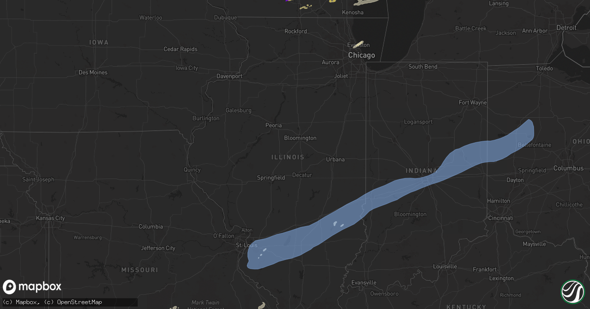
Hail Map in Illinois on April 18, 2025
Get this storm
April 18 map
$229
one time, instant access
Download today. No call, no setup
Keep the $229
Bought the map and want the full workflow? Apply the entire $229 to a subscription within 7 days. None of it is wasted.
Every map, not just this one
This buys you this map. Subscription and you get every map we run, in the markets you choose from a few cities to whole states to nationwide. Plus real-time alerts the moment a storm fires.
Contact data
Name, contact info, occupancy, even credit band for addresses in the footprint. You go from where it hit to who to call.
Become the source they trust
Unlimited branding weather history reports on demand. You already have the documented answer ready for the property owner, and you are the one who showed up with it.
Property data and RoofTrace estimates
Pull up any address you have got, its value and the exact code rules for that jurisdiction, straight from One Click Code. Then RoofTrace estimates the squares, pitch, and roof value, priced the way you price.
Storm reports in Illinois
Illinois
| Date | Description |
|---|---|
| 04/18/20252:58 AM CDT | Tree blocking a road. |
| 04/18/20252:55 AM CDT | Several power poles down near the intersection of sailor springs rd. And venus rd. |
| 04/18/20252:55 AM CDT | Barns... Trees... And power poles down from 2 miles north of flora through north part of county. |
| 04/18/20252:45 AM CDT | Carport damaged and tree limbs down. |
| 04/18/20252:39 AM CDT | Mutiple trees down around forbes state park. Time estimated by radar. |
| 04/18/20252:38 AM CDT | A couple of outbuildings were destroyed along kinmundy road just south of williams road. Time estimated by radar. |
| 04/18/20252:32 AM CDT | Damage to a barn roof observed... A few pieces of sheet metal strewn into a nearby field. |
| 04/18/20252:30 AM CDT | Numerous trees and power lines down all over town. Some trees blown onto homes. Time estimated. |
| 04/18/20252:25 AM CDT | Tree limbs and powerlines down near w kell and n cherry. Time estimated by radar. |
| 04/18/20251:44 AM CDT | Metal roof damage at intersection of route 15 and 13. Time estimated from radar. |
All States Impacted by Hail Map on April 18, 2025
Cities Impacted by Hail Map on April 18, 2025
- Brooklyn, WI
- Stoughton, WI
- Evansville, WI
- Edgerton, WI
- Milton, WI
- Deerfield, WI
- Marshall, WI
- Lake Mills, WI
- Waterloo, WI
- Cambridge, WI
- Middleton, WI
- Waunakee, WI
- Janesville, WI
- Jefferson, WI
- Johnson Creek, WI
- Fort Atkinson, WI
- Black Earth, WI
- Cross Plains, WI
- Deforest, WI
- Rio, WI
- Arlington, WI
- Morrisonville, WI
- Whitewater, WI
- Cottage Grove, WI
- Lodi, WI
- Madison, WI
- Mount Horeb, WI
- Oconomowoc, WI
- Hartland, WI
- Watertown, WI
- Ixonia, WI
- Sullivan, WI
- Helenville, WI
- Palmyra, WI
- Eagle, WI
- Mukwonago, WI
- Dousman, WI
- Waukesha, WI
- North Prairie, WI
- Sun Prairie, WI
- Nashotah, WI
- Okauchee, WI
- Mcfarland, WI
- New Berlin, WI
- Wales, WI
- Oregon, WI
- Delafield, WI
- Milwaukee, WI
- Beloit, WI
- Saint Francis, WI
- Ashippun, WI
- Avalon, WI
- Delavan, WI
- Darien, WI
- Hartford, WI
- Pewaukee, WI
- East Troy, WI
- Burlington, WI
- Big Bend, WI
- Waterford, WI
- Brookfield, WI
- Menomonee Falls, WI
- Elkhorn, WI
- Muskego, WI
- Union Grove, WI
- Franksville, WI
- Oak Creek, WI
- Caledonia, WI
- Racine, WI
- Sussex, WI
- Blue Mounds, WI
- Verona, WI
- Cudahy, WI
- Spring Green, WI
- Dodgeville, WI
- Arena, WI
- Barneveld, WI
- Reeseville, WI
- Butler, WI
- Afton, WI
- Franklin, WI
- Greendale, WI
- Rochester, WI
- Ralls, TX
- Laingsburg, MI
- Owosso, MI
- Tahlequah, OK
- Hulbert, OK
- Twin Oaks, OK
- Kansas, OK
- Colcord, OK
- Oaks, OK
- Rose, OK
- Peggs, OK
- Wynnewood, OK
- Elmore City, OK
- Jay, OK
- Maysville, AR
- Gentry, AR
- Decatur, AR
- Gravette, AR
- Pauls Valley, OK
- Branch, MI
- Fountain, MI
- Custer, MI
- Stratford, OK
- Irons, MI
- Baldwin, MI
- Luther, MI
- Ludington, MI
- Cadillac, MI
- Stark City, MO
- Hiwasse, AR
- Ada, OK
- Byars, OK
- Free Soil, MI
- Bentonville, AR
- Bella Vista, AR
- Bowie, TX
- Bellevue, TX
- Manistee, MI
- Konawa, OK
- Pineville, MO
- Asher, OK
- Maud, OK
- Pea Ridge, AR
- Seligman, MO
- Washburn, MO
- Ryan, OK
- Westville, OK
- Proctor, OK
- Nocona, TX
- Sasakwa, OK
- Wewoka, OK
- Watts, OK
- Siloam Springs, AR
- Exeter, MO
- Ringgold, TX
- Cassville, MO
- Montague, TX
- Saint Jo, TX
- Ringling, OK
- Wilson, OK
- Grayling, MI
- Scotland, TX
- Roscommon, MI
- Springfield, MO
- Holdenville, OK
- Nixa, MO
- Wellston, MI
- Brethren, MI
- Tustin, MI
- Leroy, MI
- Ozark, MO
- Leon, OK
- Burneyville, OK
- Chase, MI
- Idlewild, MI
- Centerton, AR
- Purdy, MO
- Garfield, AR
- Aurora, MO
- Rogersville, MO
- Seminole, OK
- Wetumka, OK
- Okemah, OK
- Weleetka, OK
- Dustin, OK
- Okmulgee, OK
- Henryetta, OK
- Overbrook, OK
- Marietta, OK
- Lone Grove, OK
- Ardmore, OK
- Muenster, TX
- Eagle Rock, MO
- Davis, OK
- Sulphur, OK
- Marshfield, MO
- Seymour, MO
- Fordland, MO
- Roff, OK
- Chelsea, OK
- Claremore, OK
- Chicago, IL
- Niles, IL
- Lincolnwood, IL
- Skokie, IL
- Highlandville, MO
- Rush Springs, OK
- Mannsville, OK
- Evanston, IL
- Madill, OK
- Wilmette, IL
- Bradley, OK
- Morton Grove, IL
- Hartville, MO
- Nowata, OK
- Vinita, OK
- Haskell, OK
- Morris, OK
- Beggs, OK
- Bixby, OK
- Oktaha, OK
- Boynton, OK
- Council Hill, OK
- Coweta, OK
- Porter, OK
- Redbird, OK
- Taft, OK
- Muskogee, OK
- Earlsboro, OK
- Marlow, OK
- Vanderbilt, MI
- Bluejacket, OK
- Wagoner, OK
- Fort Gibson, OK
- Blanchard, OK
- Ozona, TX
- Graff, MO
- Huggins, MO
- Plato, MO
- Mountain Grove, MO
- Tupelo, OK
- Washington, OK
- Newcastle, OK
- Norman, OK
- Oklahoma City, OK
- Barnhart, TX
- Success, MO
- Bucyrus, MO
- Millersburg, MI
- Centrahoma, OK
- Mertzon, TX
- Welling, OK
- Park Hill, OK
- Stilwell, OK
- Stuart, OK
- Calvin, OK
- Coalgate, OK
- Licking, MO
- Guthrie, OK
- Edmond, OK
- Stonewall, OK
- Fitzhugh, OK
- Salem, MO
- Winters, TX
- Allen, OK
- Stillwater, OK
- Pawnee, OK
- San Angelo, TX
- Carlsbad, TX
- Perry, OK
- Morrison, OK
- Bronte, TX
- Norton, TX
- Wingate, TX
- Macomb, OK
- Robert Lee, TX
- Paoli, OK
- Wayne, OK
- Atwood, OK
- Glencoe, OK
- Summers, AR
- Fayetteville, AR
- Springdale, AR
- Miles, TX
- Lawn, TX
- Eldorado, TX
- Ballinger, TX
- Terral, OK
- Ovalo, TX
- Henrietta, TX
- Cave Springs, AR
- Lowell, AR
- Rogers, AR
- Porum, OK
- Abilene, TX
- Tuscola, TX
- New Athens, IL
- Coyle, OK
- Perkins, OK
- Republic, MO
- Brookline, MO
- Christoval, TX
- Sallisaw, OK
- Bunch, OK
- Mascoutah, IL
- Trenton, IL
- Lebanon, IL
- Tishomingo, OK
- Meridian, OK
- Spencer, OK
- Jones, OK
- Freeburg, IL
- Novice, TX
- Talpa, TX
- Goldsboro, TX
- Clyde, TX
- Baird, TX
- Vancourt, TX
- Coleman, TX
- Cross Plains, TX
- Albany, TX
- Cisco, TX
- Moran, TX
- Comstock, TX
- Waterloo, IL
- Millstadt, IL
- Columbia, IL
- Belleville, IL
- Fairview Heights, IL
- Dupo, IL
- East Saint Louis, IL
- East Carondelet, IL
- Caseyville, IL
- Collinsville, IL
- Marissa, IL
- Red Bud, IL
- Smithton, IL
- Baldwin, IL
- Lenzburg, IL
- O'Fallon, IL
- Hecker, IL
- Fults, IL
- Scott Air Force Base, IL
- Maryville, IL
- Saint Jacob, IL
- Troy, IL
- Albers, IL
- Aviston, IL
- Greenville, IL
- Addieville, IL
- Germantown, IL
- Carlyle, IL
- New Baden, IL
- Breese, IL
- Highland, IL
- Summerfield, IL
- Pocahontas, IL
- Bartelso, IL
- Coulterville, IL
- Saint Libory, IL
- Richview, IL
- Centralia, IL
- Okawville, IL
- Nashville, IL
- Hoffman, IL
- Oakdale, IL
- Hoyleton, IL
- Keyesport, IL
- Beckemeyer, IL
- Vandalia, IL
- Smithboro, IL
- Mulberry Grove, IL
- Patoka, IL
- Alma, IL
- Shobonier, IL
- Sandoval, IL
- Odin, IL
- Salem, IL
- Kinmundy, IL
- Irvington, IL
- Vernon, IL
- Walnut Hill, IL
- Iuka, IL
- Xenia, IL
- Kell, IL
- Johnsonville, IL
- Dix, IL
- Woodlawn, IL
- Wall, TX
- Natural Dam, AR
- Evansville, AR
- Prairie Grove, AR
- Gladwin, MI
- Canehill, AR
- Breckenridge, TX
- Eastland, TX
- Ranger, TX
- Caddo, TX
- Sonora, TX
- West Fork, AR
- Del Rio, TX
- Elkins, AR
- Flora, IL
- Ingraham, IL
- Farina, IL
- Louisville, IL
- Clay City, IL
- Dieterich, IL
- Mason, IL
- Edgewood, IL
- Saint Peter, IL
- Brownstown, IL
- Saint Elmo, IL
- Watson, IL
- Newton, IL
- Strawn, TX
- Gordon, TX
- Palo Pinto, TX
- Mingus, TX
- Wheeler, IL
- Hindsville, AR
- Wesley, AR
- Huntsville, AR
- Green Forest, AR
- Berryville, AR
- Willow Hill, IL
- Ripley, OK
- Alpena, AR
- Choctaw, OK
- Tuttle, OK
- Tryon, OK
- Harrison, AR
- Bridgeport, TX
- Chico, TX
- Lead Hill, AR
- Sunset, TX
- Yellville, AR
- Peel, AR
- Purcell, OK
- Alvord, TX
- Ellington, MO
- Redford, MO
- Centerville, MO
- Effingham, IL
- Montrose, IL
- Toledo, IL
- Altamont, IL
- Jewett, IL
- Teutopolis, IL
- Hidalgo, IL
- Greenup, IL
- Casey, IL
- Martinsville, IL
- Marshall, IL
- Yale, IL
- Noble, IL
- Farmersburg, IN
- Fairbanks, IN
- West York, IL
- Robinson, IL
- Dundas, IL
- Sailor Springs, IL
- Sullivan, IN
- West Union, IL
- Shelburn, IN
- Sainte Marie, IL
- Hutsonville, IL
- Annapolis, IL
- West Liberty, IL
- Oblong, IL
- Terre Haute, IN
- Merom, IN
- Palestine, IL
- Stoy, IL
- Olney, IL
- Dennison, IL
- Rosedale, IN
- West Terre Haute, IN
- Paris, IL
- Brazil, IN
- Carbon, IN
- Pimento, IN
- Bainbridge, IN
- Riley, IN
- Staunton, IN
- Greencastle, IN
- Poland, IN
- Clay City, IN
- Knightsville, IN
- Cory, IN
- Bowling Green, IN
- Reelsville, IN
- Lewis, IN
- Cloverdale, IN
- Harmony, IN
- Putnamville, IN
- Quincy, IN
- Centerpoint, IN
- Spencer, IN
- Danville, IN
- Fillmore, IN
- North Salem, IN
- Coatesville, IN
- Avon, IN
- Stilesville, IN
- Clayton, IN
- Amo, IN
- Monrovia, IN
- Plainfield, IN
- Martinsville, IN
- Indianapolis, IN
- Mooresville, IN
- West Newton, IN
- Camby, IN
- Beech Grove, IN
- New Palestine, IN
- Pendleton, IN
- Mccordsville, IN
- Greenfield, IN
- Fortville, IN
- Ingalls, IN
- Fishers, IN
- Anderson, IN
- Lapel, IN
- Alexandria, IN
- Yorktown, IN
- Gaston, IN
- Daleville, IN
- Muncie, IN
- Maxwell, IN
- Dunkirk, IN
- Eaton, IN
- Middletown, IN
- Wilkinson, IN
- Markleville, IN
- Albany, IN
- Mooreland, IN
- Redkey, IN
- Charlottesville, IN
- Ridgeville, IN
- Economy, IN
- Shirley, IN
- Selma, IN
- Modoc, IN
- Kennard, IN
- Knightstown, IN
- Springport, IN
- Hagerstown, IN
- Winchester, IN
- Farmland, IN
- Losantville, IN
- Parker City, IN
- Lynn, IN
- Williamsburg, IN
- New Castle, IN
- Portland, IN
- New Weston, OH
- Union City, IN
- Union City, OH
- Fort Recovery, OH
- Salamonia, IN
- Saint Henry, OH
- Saratoga, IN
- Versailles, OH
- Bradford, OH
- Yorkshire, OH
- Rossburg, OH
- Maria Stein, OH
- Ansonia, OH
- Greenville, OH
- Burkettsville, OH
- Pryor, OK
- Salina, OK
- Locust Grove, OK
- Perryville, MO
- Daisy, MO
- Friedheim, MO
- Sedgewickville, MO
- Marble Hill, MO
- Harrod, OH
- Lafayette, OH
- Anna, OH
- Houston, OH
- Minster, OH
- Wapakoneta, OH
- Fort Loramie, OH
- Saint Marys, OH
- Montezuma, OH
- Chickasaw, OH
- Buckland, OH
- Celina, OH
- New Knoxville, OH
- Lima, OH
- New Bremen, OH
- Osgood, OH
- Coldwater, OH
- Russia, OH
- Botkins, OH
- Quincy, OH
- Huntsville, OH
- Belle Center, OH
- Piqua, OH
- Roundhead, OH
- Port Jefferson, OH
- De Graff, OH
- Lakeview, OH
- Ada, OH
- Sidney, OH
- Lewistown, OH
- Covington, OH
- Russells Point, OH
- Uniopolis, OH
- Jackson Center, OH
- Maplewood, OH
- New Hampshire, OH
- Waynesfield, OH
- Gettysburg, OH
- Kenton, OH
- McGuffey, OH
- Alger, OH
- Mcalester, OK
- Junction, TX
- Mason, TX


