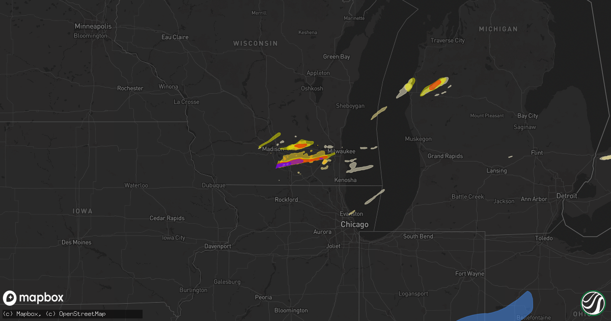
Hail Map on April 18, 2025
Get this storm
April 18 map
$229
one time, instant access
Download today. No call, no setup
Keep the $229
Bought the map and want the full workflow? Apply the entire $229 to a subscription within 7 days. None of it is wasted.
Every map, not just this one
This buys you this map. Subscription and you get every map we run, in the markets you choose from a few cities to whole states to nationwide. Plus real-time alerts the moment a storm fires.
Contact data
Name, contact info, occupancy, even credit band for addresses in the footprint. You go from where it hit to who to call.
Become the source they trust
Unlimited branding weather history reports on demand. You already have the documented answer ready for the property owner, and you are the one who showed up with it.
Property data and RoofTrace estimates
Pull up any address you have got, its value and the exact code rules for that jurisdiction, straight from One Click Code. Then RoofTrace estimates the squares, pitch, and roof value, priced the way you price.
States Impacted by Hail Map on April 18, 2025
Storm reports
Illinois
| Date | Description |
|---|---|
| 04/18/20252:58 AM CDT | Tree blocking a road. |
| 04/18/20252:55 AM CDT | Several power poles down near the intersection of sailor springs rd. And venus rd. |
| 04/18/20252:55 AM CDT | Barns... Trees... And power poles down from 2 miles north of flora through north part of county. |
| 04/18/20252:45 AM CDT | Carport damaged and tree limbs down. |
| 04/18/20252:39 AM CDT | Mutiple trees down around forbes state park. Time estimated by radar. |
| 04/18/20252:38 AM CDT | A couple of outbuildings were destroyed along kinmundy road just south of williams road. Time estimated by radar. |
| 04/18/20252:32 AM CDT | Damage to a barn roof observed... A few pieces of sheet metal strewn into a nearby field. |
| 04/18/20252:30 AM CDT | Numerous trees and power lines down all over town. Some trees blown onto homes. Time estimated. |
| 04/18/20252:25 AM CDT | Tree limbs and powerlines down near w kell and n cherry. Time estimated by radar. |
| 04/18/20251:44 AM CDT | Metal roof damage at intersection of route 15 and 13. Time estimated from radar. |
Iowa
| Date | Description |
|---|---|
| 04/18/20257:00 AM CDT | A local report indicates 1.00 inch wind near McGregor |
Wisconsin
| Date | Description |
|---|---|
| 04/18/202512:02 PM CDT | A local report indicates 1.50 inch wind near 6 SW Brooklyn |
| 04/18/20258:40 AM CDT | Report from mping: quarter |
| 04/18/20258:00 AM CDT | A local report indicates 1.00 inch wind near 1 E New Berlin |
| 04/18/20257:53 AM CDT | Report from mping: quarter |
| 04/18/20257:52 AM CDT | Report from mping: quarter |
| 04/18/20257:50 AM CDT | Report from mping: quarter |
| 04/18/20257:50 AM CDT | Report from mping: half dollar |
| 04/18/20257:49 AM CDT | Ranged from nickel size to lime size in the first batch... Then a second wave hit with more nickel/quarter size hail. |
| 04/18/20257:46 AM CDT | Report from mping: quarter |
| 04/18/20257:46 AM CDT | A local report indicates 1.00 inch wind near 3 S Waukesha |
| 04/18/20257:45 AM CDT | Relayed by wisn media with photo. Time estimated from radar. |
| 04/18/20257:45 AM CDT | Report from mping: golf ball |
| 04/18/20257:45 AM CDT | A local report indicates 1.50 inch wind near 3 SE North Prairie |
| 04/18/20257:44 AM CDT | A local report indicates 1.50 inch wind near 3 WNW Mukwonago |
| 04/18/20257:44 AM CDT | Report from mping: half dollar |
| 04/18/20257:41 AM CDT | A local report indicates 1.50 inch wind near 4 ENE North Prairie |
| 04/18/20257:39 AM CDT | A local report indicates 1.00 inch wind near Verona |
| 04/18/20257:38 AM CDT | Report from mping: quarter |
| 04/18/20257:36 AM CDT | Report from mping: golf ball |
| 04/18/20257:31 AM CDT | Report from mping: half dollar |
| 04/18/20257:27 AM CDT | Report from mping: half dollar |
| 04/18/20257:26 AM CDT | Hail size measured around 2.34in. No damage to report at this time. |
| 04/18/20257:25 AM CDT | A local report indicates 1.00 inch wind near 1 ENE Lac La Belle |
| 04/18/20257:18 AM CDT | A local report indicates 1.50 inch wind near Hollandale |
| 04/18/20257:17 AM CDT | A local report indicates 1.00 inch wind near De Forest |
| 04/18/20257:15 AM CDT | Half mile north of lake koshkonong. |
| 04/18/20257:15 AM CDT | A local report indicates 1.75 inch wind near 1 SE Edgerton |
| 04/18/20257:14 AM CDT | A local report indicates 2.00 inch wind near 3 E Edgerton |
| 04/18/20257:14 AM CDT | Tennis ball sized hail falling as of 7:12 am with damage to vehicles. |
| 04/18/20257:13 AM CDT | A local report indicates 1.00 inch wind near 3 N Edgerton |
| 04/18/20257:13 AM CDT | A local report indicates 1.25 inch wind near 2 E Dodgeville |
| 04/18/20257:11 AM CDT | Relayed by relative of nws employee... With photo. |
| 04/18/20257:11 AM CDT | Report from mping: quarter |
| 04/18/20257:10 AM CDT | Golf ball size hail. Some even larger. Some tree damage and car dents. |
| 04/18/20257:10 AM CDT | A local report indicates 2.75 inch wind near Edgerton |
| 04/18/20257:09 AM CDT | Report from mping: half dollar |
| 04/18/20257:09 AM CDT | A local report indicates 1.75 inch wind near 4 ENE Lake Mills |
| 04/18/20257:08 AM CDT | A local report indicates 2.50 inch wind near Edgerton |
| 04/18/20257:06 AM CDT | A local report indicates 1.00 inch wind near Lake Mills |
| 04/18/20257:05 AM CDT | A local report indicates 1.75 inch wind near Evansville |
| 04/18/20257:02 AM CDT | A local report indicates 2.75 inch wind near 4 W Edgerton |
| 04/18/20257:00 AM CDT | Photo sent by relative on nws employee. |
| 04/18/20257:00 AM CDT | A local report indicates 2.00 inch wind near 1 E Evansville |
Utah
| Date | Description |
|---|---|
| 04/18/20251:15 PM CDT | [landspout] pictures from social media indicated a landspout tornado just west of i-15 between cedar city... Ut and enoch... Ut. Time and location are approximate. |
Ohio
| Date | Description |
|---|---|
| 04/18/20256:52 AM CDT | Tree with some poles down on cr 6 near state route 587. Time estimated via radar. |
| 04/18/20256:45 AM CDT | Corrects previous tstm wnd dmg report from 3 sse la rue. Several powerlines blown down around bowling green township...corrected time estimate. |
| 04/18/20256:44 AM CDT | A large tree was blown down in upper sandusky. |
| 04/18/20256:38 AM CDT | Asos station kfdy findlay. |
| 04/18/20256:16 AM CDT | A couple of trees down in ada. Time estimated from radar. |
| 04/18/20256:15 AM CDT | Awos station kaoh lima... Oh. |
| 04/18/20256:01 AM CDT | Measured on a private weather station. |
| 04/18/20255:59 AM CDT | A local report indicates 63 MPH wind near 1 E New Knoxville |
| 04/18/20255:55 AM CDT | Roof shingles blown off building. Time estimated from radar data. |
Missouri
| Date | Description |
|---|---|
| 04/18/20253:43 PM CDT | Tree and power line down on turnbo rd 1043 pm via 911. |
| 04/18/20255:36 AM CDT | A tree was snapped near its base and fell on a utv... Doing extensive damage. |
| 04/18/20254:40 AM CDT | Some trees and large tree limbs were downed. |
| 04/17/202510:43 PM CDT | Trees down on pleasant hill rd 1043 pm via 911. |
| 04/17/202510:15 PM CDT | A national weather service survey found a brief ef-0 tornado touched down in far southeastern greene county. Damage included broken branches and damage to a few outbuil |
Michigan
| Date | Description |
|---|---|
| 04/18/202512:19 PM CDT | Measured at port hope. |
| 04/17/20259:10 PM CDT | A local report indicates 1.50 inch wind near 6 E Irons |
Indiana
| Date | Description |
|---|---|
| 04/18/20256:32 AM CDT | Thunderstorm winds downed multiple power lines across southern madison county and in anderson. Time estimated by radar. |
| 04/18/20255:37 AM CDT | A barn had its siding blown off and blown into the field nearby. The structure underneath still appears intact. Mesonet and other stations nearby indicate 45 to 55 mph |
| 04/18/20255:18 AM CDT | Thunderstorm winds downed trees and or power lines south of albany. Time estimated by radar. |
| 04/18/20255:11 AM CDT | Thunderstorm winds uprooted a tree into a house. Time estimated by radar. |
| 04/18/20254:56 AM CDT | Interstate 69 was closed at mm 222 due to thunderstorm winds downing lines onto roadway. Time estimated by radar. |
| 04/18/20254:53 AM CDT | Thunderstorm winds downed multiple power lines across southern madison county and in anderson. Time estimated by radar. |
| 04/18/20254:52 AM CDT | Thunderstorm winds downed trees just east of noblesville. Time estimated by radar. |
| 04/18/20254:34 AM CDT | Thunderstorm winds uprooted a tree at 38th street and guion road. Time estimated by radar. |
| 04/18/20254:33 AM CDT | Thunderstorm wind gust at kind indianapolis. |
| 04/18/20254:33 AM CDT | Thunderstorm wind gust at kind indianapolis. |
| 04/18/20254:30 AM CDT | Ronald reagan pkwy and us highway 36. |
| 04/18/20254:28 AM CDT | Thunderstorm winds downed several large trees on the south side of brownsburg including at the intersection of thornburg pkwy and indiana route 267. Time estimated by r |
| 04/18/20254:15 AM CDT | Thunderstorm wind gust at kgpc greencastle. |
| 04/18/20254:09 AM CDT | Several pictures from putnam county of trees downed by thunderstorm winds onto cars. Time estimated by radar. |
| 04/18/20253:56 AM CDT | Thunderstorm winds damaged trees on west side of brazil. Time estimated by radar. |
| 04/18/20253:56 AM CDT | Thunderstorm winds downed trees at us highway 40 and county road 100 east causing minor structural damage to a 3 car garage. Time estimated by radar. |
| 04/18/20253:49 AM CDT | Thunderstorm wind gust at khuf terre haute. |
| 04/18/20253:47 AM CDT | Thunderstorm winds downed tree branches onto a house in terre haute. Time estimated from radar. |
Oklahoma
| Date | Description |
|---|---|
| 04/18/202512:34 AM CDT | Report from mping: half dollar |
| 04/18/202512:28 AM CDT | A local report indicates 1.25 inch wind near 3 SSE Ada |
| 04/18/202512:27 AM CDT | Report from mping: ping pong ball |
| 04/17/202511:56 PM CDT | Report from mping: quarter |
| 04/17/202511:52 PM CDT | At oak ridge elementary school. |
| 04/17/202511:51 PM CDT | Report from mping: half dollar |
| 04/17/202511:49 PM CDT | Report from mping: half dollar |
| 04/17/202511:48 PM CDT | A local report indicates 1.38 inch wind near 3 SSW Moore |
| 04/17/202511:47 PM CDT | A local report indicates 1.00 inch wind near 5 S Moore |
| 04/17/202510:30 PM CDT | Small storage shed toppled over east of the intersection of dixon and eastman rd. Time estimated from radar. |
| 04/17/202510:21 PM CDT | Near belleville rd and grant rd. |
| 04/17/202510:20 PM CDT | Approx. 3ft diameter tree downed near corner of buchanan circle and commerce ave. Radar estimated time. |
| 04/17/20259:50 PM CDT | A local report indicates 65 MPH wind near 4 E Konawa |
| 04/17/20259:45 PM CDT | A local report indicates 1.00 inch wind near Konawa |
| 04/17/20259:35 PM CDT | A local report indicates 1.75 inch wind near 8 N Vanoss |
| 04/17/20259:05 PM CDT | A local report indicates 1.75 inch wind near 4 W Stratford |
Texas
| Date | Description |
|---|---|
| 04/18/20252:35 AM CDT | Awos station kgzn in cisco measured a wind gust of 60 mph. |
| 04/18/20251:40 AM CDT | Public reported quarter size hail on twin mountain dr in san angelo at 1:40 am via facebook. |
| 04/18/20251:20 AM CDT | A local report indicates 1.25 inch wind near 3 SSE Tankersley |
| 04/17/202510:05 PM CDT | Quarter size hail and estimated 50 mph wind gusts. |
| 04/17/202510:00 PM CDT | Multiple broken tree limbs on fm 677 just south of the red river. |
| 04/17/20259:55 PM CDT | 1.25 inch hail reported near the intersection of 1806 and copeland rd by off-duty nws employee. |
| 04/17/20259:53 PM CDT | 60 mph winds and nickel size hail reported near stoneburg. |
Arkansas
| Date | Description |
|---|---|
| 04/18/20251:09 AM CDT | Powerlines downed and snapped in subdivision... Possible tornado. Time estimated from radar. |
| 04/17/202510:06 PM CDT | Estimated ping pong ball from pic...time estimated from radar. |
| 04/17/20259:58 PM CDT | Tree down... Time estimated from radar. |
| 04/17/20259:55 PM CDT | Time estimated from radar. |
| 04/17/20259:53 PM CDT | Several trees snapped and limbs down... Winds estimated 70-75mph from broadcast storm spotter. Time estimated from radar. |
| 04/17/20259:00 PM CDT | Tree blown down. |
Cities Impacted by Hail Map on April 18, 2025
- Brooklyn, WI
- Stoughton, WI
- Evansville, WI
- Edgerton, WI
- Milton, WI
- Deerfield, WI
- Marshall, WI
- Lake Mills, WI
- Waterloo, WI
- Cambridge, WI
- Middleton, WI
- Waunakee, WI
- Janesville, WI
- Jefferson, WI
- Johnson Creek, WI
- Fort Atkinson, WI
- Black Earth, WI
- Cross Plains, WI
- Deforest, WI
- Rio, WI
- Arlington, WI
- Morrisonville, WI
- Whitewater, WI
- Cottage Grove, WI
- Lodi, WI
- Madison, WI
- Mount Horeb, WI
- Oconomowoc, WI
- Hartland, WI
- Watertown, WI
- Ixonia, WI
- Sullivan, WI
- Helenville, WI
- Palmyra, WI
- Eagle, WI
- Mukwonago, WI
- Dousman, WI
- Waukesha, WI
- North Prairie, WI
- Sun Prairie, WI
- Nashotah, WI
- Okauchee, WI
- Mcfarland, WI
- New Berlin, WI
- Wales, WI
- Oregon, WI
- Delafield, WI
- Milwaukee, WI
- Beloit, WI
- Saint Francis, WI
- Ashippun, WI
- Avalon, WI
- Delavan, WI
- Darien, WI
- Hartford, WI
- Pewaukee, WI
- East Troy, WI
- Burlington, WI
- Big Bend, WI
- Waterford, WI
- Brookfield, WI
- Menomonee Falls, WI
- Elkhorn, WI
- Muskego, WI
- Union Grove, WI
- Franksville, WI
- Oak Creek, WI
- Caledonia, WI
- Racine, WI
- Sussex, WI
- Blue Mounds, WI
- Verona, WI
- Cudahy, WI
- Spring Green, WI
- Dodgeville, WI
- Arena, WI
- Barneveld, WI
- Reeseville, WI
- Butler, WI
- Afton, WI
- Franklin, WI
- Greendale, WI
- Rochester, WI
- Ralls, TX
- Laingsburg, MI
- Owosso, MI
- Tahlequah, OK
- Hulbert, OK
- Twin Oaks, OK
- Kansas, OK
- Colcord, OK
- Oaks, OK
- Rose, OK
- Peggs, OK
- Wynnewood, OK
- Elmore City, OK
- Jay, OK
- Maysville, AR
- Gentry, AR
- Decatur, AR
- Gravette, AR
- Pauls Valley, OK
- Branch, MI
- Fountain, MI
- Custer, MI
- Stratford, OK
- Irons, MI
- Baldwin, MI
- Luther, MI
- Ludington, MI
- Cadillac, MI
- Stark City, MO
- Hiwasse, AR
- Ada, OK
- Byars, OK
- Free Soil, MI
- Bentonville, AR
- Bella Vista, AR
- Bowie, TX
- Bellevue, TX
- Manistee, MI
- Konawa, OK
- Pineville, MO
- Asher, OK
- Maud, OK
- Pea Ridge, AR
- Seligman, MO
- Washburn, MO
- Ryan, OK
- Westville, OK
- Proctor, OK
- Nocona, TX
- Sasakwa, OK
- Wewoka, OK
- Watts, OK
- Siloam Springs, AR
- Exeter, MO
- Ringgold, TX
- Cassville, MO
- Montague, TX
- Saint Jo, TX
- Ringling, OK
- Wilson, OK
- Grayling, MI
- Scotland, TX
- Roscommon, MI
- Springfield, MO
- Holdenville, OK
- Nixa, MO
- Wellston, MI
- Brethren, MI
- Tustin, MI
- Leroy, MI
- Ozark, MO
- Leon, OK
- Burneyville, OK
- Chase, MI
- Idlewild, MI
- Centerton, AR
- Purdy, MO
- Garfield, AR
- Aurora, MO
- Rogersville, MO
- Seminole, OK
- Wetumka, OK
- Okemah, OK
- Weleetka, OK
- Dustin, OK
- Okmulgee, OK
- Henryetta, OK
- Overbrook, OK
- Marietta, OK
- Lone Grove, OK
- Ardmore, OK
- Muenster, TX
- Eagle Rock, MO
- Davis, OK
- Sulphur, OK
- Marshfield, MO
- Seymour, MO
- Fordland, MO
- Roff, OK
- Chelsea, OK
- Claremore, OK
- Chicago, IL
- Niles, IL
- Lincolnwood, IL
- Skokie, IL
- Highlandville, MO
- Rush Springs, OK
- Mannsville, OK
- Evanston, IL
- Madill, OK
- Wilmette, IL
- Bradley, OK
- Morton Grove, IL
- Hartville, MO
- Nowata, OK
- Vinita, OK
- Haskell, OK
- Morris, OK
- Beggs, OK
- Bixby, OK
- Oktaha, OK
- Boynton, OK
- Council Hill, OK
- Coweta, OK
- Porter, OK
- Redbird, OK
- Taft, OK
- Muskogee, OK
- Earlsboro, OK
- Marlow, OK
- Vanderbilt, MI
- Bluejacket, OK
- Wagoner, OK
- Fort Gibson, OK
- Blanchard, OK
- Ozona, TX
- Graff, MO
- Huggins, MO
- Plato, MO
- Mountain Grove, MO
- Tupelo, OK
- Washington, OK
- Newcastle, OK
- Norman, OK
- Oklahoma City, OK
- Barnhart, TX
- Success, MO
- Bucyrus, MO
- Millersburg, MI
- Centrahoma, OK
- Mertzon, TX
- Welling, OK
- Park Hill, OK
- Stilwell, OK
- Stuart, OK
- Calvin, OK
- Coalgate, OK
- Licking, MO
- Guthrie, OK
- Edmond, OK
- Stonewall, OK
- Fitzhugh, OK
- Salem, MO
- Winters, TX
- Allen, OK
- Stillwater, OK
- Pawnee, OK
- San Angelo, TX
- Carlsbad, TX
- Perry, OK
- Morrison, OK
- Bronte, TX
- Norton, TX
- Wingate, TX
- Macomb, OK
- Robert Lee, TX
- Paoli, OK
- Wayne, OK
- Atwood, OK
- Glencoe, OK
- Summers, AR
- Fayetteville, AR
- Springdale, AR
- Miles, TX
- Lawn, TX
- Eldorado, TX
- Ballinger, TX
- Terral, OK
- Ovalo, TX
- Henrietta, TX
- Cave Springs, AR
- Lowell, AR
- Rogers, AR
- Porum, OK
- Abilene, TX
- Tuscola, TX
- New Athens, IL
- Coyle, OK
- Perkins, OK
- Republic, MO
- Brookline, MO
- Christoval, TX
- Sallisaw, OK
- Bunch, OK
- Mascoutah, IL
- Trenton, IL
- Lebanon, IL
- Tishomingo, OK
- Meridian, OK
- Spencer, OK
- Jones, OK
- Freeburg, IL
- Novice, TX
- Talpa, TX
- Goldsboro, TX
- Clyde, TX
- Baird, TX
- Vancourt, TX
- Coleman, TX
- Cross Plains, TX
- Albany, TX
- Cisco, TX
- Moran, TX
- Comstock, TX
- Waterloo, IL
- Millstadt, IL
- Columbia, IL
- Belleville, IL
- Fairview Heights, IL
- Dupo, IL
- East Saint Louis, IL
- East Carondelet, IL
- Caseyville, IL
- Collinsville, IL
- Marissa, IL
- Red Bud, IL
- Smithton, IL
- Baldwin, IL
- Lenzburg, IL
- O'Fallon, IL
- Hecker, IL
- Fults, IL
- Scott Air Force Base, IL
- Maryville, IL
- Saint Jacob, IL
- Troy, IL
- Albers, IL
- Aviston, IL
- Greenville, IL
- Addieville, IL
- Germantown, IL
- Carlyle, IL
- New Baden, IL
- Breese, IL
- Highland, IL
- Summerfield, IL
- Pocahontas, IL
- Bartelso, IL
- Coulterville, IL
- Saint Libory, IL
- Richview, IL
- Centralia, IL
- Okawville, IL
- Nashville, IL
- Hoffman, IL
- Oakdale, IL
- Hoyleton, IL
- Keyesport, IL
- Beckemeyer, IL
- Vandalia, IL
- Smithboro, IL
- Mulberry Grove, IL
- Patoka, IL
- Alma, IL
- Shobonier, IL
- Sandoval, IL
- Odin, IL
- Salem, IL
- Kinmundy, IL
- Irvington, IL
- Vernon, IL
- Walnut Hill, IL
- Iuka, IL
- Xenia, IL
- Kell, IL
- Johnsonville, IL
- Dix, IL
- Woodlawn, IL
- Wall, TX
- Natural Dam, AR
- Evansville, AR
- Prairie Grove, AR
- Gladwin, MI
- Canehill, AR
- Breckenridge, TX
- Eastland, TX
- Ranger, TX
- Caddo, TX
- Sonora, TX
- West Fork, AR
- Del Rio, TX
- Elkins, AR
- Flora, IL
- Ingraham, IL
- Farina, IL
- Louisville, IL
- Clay City, IL
- Dieterich, IL
- Mason, IL
- Edgewood, IL
- Saint Peter, IL
- Brownstown, IL
- Saint Elmo, IL
- Watson, IL
- Newton, IL
- Strawn, TX
- Gordon, TX
- Palo Pinto, TX
- Mingus, TX
- Wheeler, IL
- Hindsville, AR
- Wesley, AR
- Huntsville, AR
- Green Forest, AR
- Berryville, AR
- Willow Hill, IL
- Ripley, OK
- Alpena, AR
- Choctaw, OK
- Tuttle, OK
- Tryon, OK
- Harrison, AR
- Bridgeport, TX
- Chico, TX
- Lead Hill, AR
- Sunset, TX
- Yellville, AR
- Peel, AR
- Purcell, OK
- Alvord, TX
- Ellington, MO
- Redford, MO
- Centerville, MO
- Effingham, IL
- Montrose, IL
- Toledo, IL
- Altamont, IL
- Jewett, IL
- Teutopolis, IL
- Hidalgo, IL
- Greenup, IL
- Casey, IL
- Martinsville, IL
- Marshall, IL
- Yale, IL
- Noble, IL
- Farmersburg, IN
- Fairbanks, IN
- West York, IL
- Robinson, IL
- Dundas, IL
- Sailor Springs, IL
- Sullivan, IN
- West Union, IL
- Shelburn, IN
- Sainte Marie, IL
- Hutsonville, IL
- Annapolis, IL
- West Liberty, IL
- Oblong, IL
- Terre Haute, IN
- Merom, IN
- Palestine, IL
- Stoy, IL
- Olney, IL
- Dennison, IL
- Rosedale, IN
- West Terre Haute, IN
- Paris, IL
- Brazil, IN
- Carbon, IN
- Pimento, IN
- Bainbridge, IN
- Riley, IN
- Staunton, IN
- Greencastle, IN
- Poland, IN
- Clay City, IN
- Knightsville, IN
- Cory, IN
- Bowling Green, IN
- Reelsville, IN
- Lewis, IN
- Cloverdale, IN
- Harmony, IN
- Putnamville, IN
- Quincy, IN
- Centerpoint, IN
- Spencer, IN
- Danville, IN
- Fillmore, IN
- North Salem, IN
- Coatesville, IN
- Avon, IN
- Stilesville, IN
- Clayton, IN
- Amo, IN
- Monrovia, IN
- Plainfield, IN
- Martinsville, IN
- Indianapolis, IN
- Mooresville, IN
- West Newton, IN
- Camby, IN
- Beech Grove, IN
- New Palestine, IN
- Pendleton, IN
- Mccordsville, IN
- Greenfield, IN
- Fortville, IN
- Ingalls, IN
- Fishers, IN
- Anderson, IN
- Lapel, IN
- Alexandria, IN
- Yorktown, IN
- Gaston, IN
- Daleville, IN
- Muncie, IN
- Maxwell, IN
- Dunkirk, IN
- Eaton, IN
- Middletown, IN
- Wilkinson, IN
- Markleville, IN
- Albany, IN
- Mooreland, IN
- Redkey, IN
- Charlottesville, IN
- Ridgeville, IN
- Economy, IN
- Shirley, IN
- Selma, IN
- Modoc, IN
- Kennard, IN
- Knightstown, IN
- Springport, IN
- Hagerstown, IN
- Winchester, IN
- Farmland, IN
- Losantville, IN
- Parker City, IN
- Lynn, IN
- Williamsburg, IN
- New Castle, IN
- Portland, IN
- New Weston, OH
- Union City, IN
- Union City, OH
- Fort Recovery, OH
- Salamonia, IN
- Saint Henry, OH
- Saratoga, IN
- Versailles, OH
- Bradford, OH
- Yorkshire, OH
- Rossburg, OH
- Maria Stein, OH
- Ansonia, OH
- Greenville, OH
- Burkettsville, OH
- Pryor, OK
- Salina, OK
- Locust Grove, OK
- Perryville, MO
- Daisy, MO
- Friedheim, MO
- Sedgewickville, MO
- Marble Hill, MO
- Harrod, OH
- Lafayette, OH
- Anna, OH
- Houston, OH
- Minster, OH
- Wapakoneta, OH
- Fort Loramie, OH
- Saint Marys, OH
- Montezuma, OH
- Chickasaw, OH
- Buckland, OH
- Celina, OH
- New Knoxville, OH
- Lima, OH
- New Bremen, OH
- Osgood, OH
- Coldwater, OH
- Russia, OH
- Botkins, OH
- Quincy, OH
- Huntsville, OH
- Belle Center, OH
- Piqua, OH
- Roundhead, OH
- Port Jefferson, OH
- De Graff, OH
- Lakeview, OH
- Ada, OH
- Sidney, OH
- Lewistown, OH
- Covington, OH
- Russells Point, OH
- Uniopolis, OH
- Jackson Center, OH
- Maplewood, OH
- New Hampshire, OH
- Waynesfield, OH
- Gettysburg, OH
- Kenton, OH
- McGuffey, OH
- Alger, OH
- Mcalester, OK
- Junction, TX
- Mason, TX