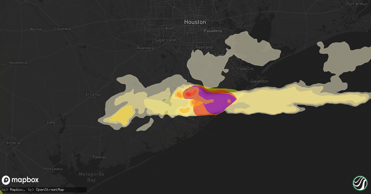
Hail Map in Angleton, TX on April 17, 2015
Get this storm
April 17 map
$229
one time, instant access
Download today. No call, no setup
Keep the $229
Bought the map and want the full workflow? Apply the entire $229 to a subscription within 7 days. None of it is wasted.
Every map, not just this one
This buys you this map. Subscription and you get every map we run, in the markets you choose from a few cities to whole states to nationwide. Plus real-time alerts the moment a storm fires.
Contact data
Name, contact info, occupancy, even credit band for addresses in the footprint. You go from where it hit to who to call.
Become the source they trust
Unlimited branding weather history reports on demand. You already have the documented answer ready for the property owner, and you are the one who showed up with it.
Property data and RoofTrace estimates
Pull up any address you have got, its value and the exact code rules for that jurisdiction, straight from One Click Code. Then RoofTrace estimates the squares, pitch, and roof value, priced the way you price.
Storm reports in Angleton, TX
Angleton, TX
| Date | Description |
|---|---|
| 04/16/20158:00 PM CDT | Quarter sized hail and 6 inch tree limbs down due to strong tstm winds in angleton. |
| 04/16/20158:00 PM CDT | Quarter sized hail and 6 inch tree limbs down due to strong tstm winds in angleton. |
| 04/16/20157:50 PM CDT | Multiple quarter sized hail reports around angleton. |
| 04/16/20157:50 PM CDT | Circus tent collapse at the angleton fairgrounds...police on scene. |
| 04/16/20157:40 PM CDT | Egg to tennis ball sized hail in angleton. |
All States Impacted by Hail Map on April 17, 2015
All Cities Impacted by Hail Map on April 17, 2015
- Beeville, TX
- Stockton, KS
- Rocksprings, TX
- Anson, TX
- Hamlin, TX
- Sweetwater, TX
- Brazoria, TX
- Damon, TX
- West Columbia, TX
- Pledger, TX
- Sweeny, TX
- Van Vleck, TX
- Paducah, TX
- Knox City, TX
- Old Glory, TX
- O'Brien, TX
- Seymour, TX
- Altus, OK
- Blair, OK
- Glade, KS
- State Line, MS
- Sonora, TX
- Winona, KS
- Anahuac, TX
- Granbury, TX
- Trent, TX
- Concepcion, TX
- Lake Jackson, TX
- Angleton, TX
- Freeport, TX
- Clute, TX
- Galveston, TX
- Danbury, TX
- Wallace, KS
- Rule, TX
- Aspermont, TX
- Yorktown, TX
- Jourdanton, TX
- Bishop, TX
- Corpus Christi, TX
- Robstown, TX
- Throckmorton, TX
- Bay City, TX
- Boling, TX
- Needville, TX
- Markham, TX
- Guy, TX
- Midfield, TX
- Rosharon, TX
- El Campo, TX
- Wharton, TX
- Wingate, TX
- Quanah, TX
- Orange Grove, TX
- San Diego, TX
- Alice, TX
- Merkel, TX
- Millsap, TX
- Santo, TX
- Aransas Pass, TX
- Portland, TX
- Gregory, TX
- San Angelo, TX
- Victoria, TX
- Houston, TX
- Pasadena, TX
- La Porte, TX
- Seabrook, TX
- Floresville, TX
- Webster, TX
- Friendswood, TX
- Logan, KS
- Inez, TX
- Beeler, KS
- Ransom, KS
- Ness City, KS
- Wakeeney, KS
- Utica, KS
- Quemado, TX
- Rockport, TX
- Cotulla, TX
- George West, TX
- Jayton, TX
- Snyder, TX
- Albany, TX
- Weatherford, TX
- Lipan, TX
- Leoti, KS
- Phillipsburg, KS
- Tilden, TX
- Mineral Wells, TX
- Goliad, TX
- Newcastle, TX
- Graham, TX
- Ogallah, KS
- Ellis, KS
- Carrizo Springs, TX
- Haskell, TX
- Brewster, KS
- Levant, KS
- Colby, KS
- Chunchula, AL
- Wilmer, AL
- Leakesville, MS
- Vinegar Bend, AL
- Perrin, TX
- Jacksboro, TX
- Woodson, TX
- Weinert, TX
- Refugio, TX
- Three Rivers, TX
- Whitsett, TX
- Abilene, TX
- Asherton, TX
- Gaylord, KS
- Alton, KS
- Crowell, TX
- Tivoli, TX
- Inola, OK
- Edna, TX
- Yoakum, TX
- Avoca, TX
- Bentonville, AR
- Bella Vista, AR
- Hiwasse, AR
- Centerton, AR
- Big Wells, TX
- Grove, OK
- South West City, MO
- Westhoff, TX
- Cuero, TX
- Chappell, NE
- Alvin, TX
- Louise, TX
- McCaulley, TX
- Kenedy, TX
- Calliham, TX
- Duke, OK
- Woodston, KS
- Brule, NE
- Big Springs, NE
- Venango, NE
- Edson, KS
- Ingleside, TX
- Taft, TX
- Camp Wood, TX
- Barksdale, TX
- Cimarron, KS
- Jetmore, KS
- Tuscola, TX
- Buffalo Gap, TX
- Garden City, KS
- Missouri City, TX
- Roma, TX
- Zapata, TX
- Falls City, TX
- Stamford, TX
- Laredo, TX
- Fresno, TX
- Crystal City, TX
- Munday, TX
- Hebbronville, TX
- Dighton, KS
- Nordheim, TX
- Brackettville, TX
- Catarina, TX
- Fowlerton, TX
- Encinal, TX
- Hawley, TX
- Christoval, TX
- Eight Mile, AL
- Rio Grande City, TX
- Rowena, TX
- Miles, TX
- Ballinger, TX
- Claremore, OK
- Pleasanton, TX
- Fort Morgan, CO
- Cameron, LA
- Savonburg, KS
- Elsmore, KS
- Sinton, TX
- Karnes City, TX
- Goodfellow Afb, TX
- Hayes Center, NE
- Eldorado, OK
- Ovalo, TX
- Merino, CO
- Wall, TX
- Port Bolivar, TX
- Winters, TX
- Poth, TX
- Bacliff, TX
- Dickinson, TX
- Medina, TX
- Cedar, KS
- Del Rio, TX
- Garwood, TX
- Blackwell, TX
- Sedan, KS
- Theriot, LA
- Eldorado, TX
- Tolar, TX
- Winnie, TX
- Olney, TX
- El Dorado, KS
- Realitos, TX
- Meyersville, TX
- Eagle Pass, TX
- Wiggins, CO
- Campbellton, TX
- Noel, MO
- Hobson, TX
- Lueders, TX
- Bronte, TX
- Norton, TX
- Palisade, NE
- Roby, TX
- Mathis, TX
- Edna, KS
- Bartlett, KS
- Liverpool, TX
- Childress, TX
- Ozona, TX
- Oswego, KS
- Mountain View, OK
- Carnegie, OK
- Hallettsville, TX
- Jay, OK
- Junction, TX
- East Bernard, TX
- Lowell, AR
- Springdale, AR
- Pineville, MO
- Anderson, MO
- Runge, TX
- San Isidro, TX
- Linn, TX
- Freer, TX
- Katy, TX
- Augusta, KS
- League City, TX
- Santa Fe, TX
- Pearland, TX
- Manvel, TX
- Kemah, TX
- Baytown, TX
- Sylvester, TX
- Nolan, TX
- Santa Elena, TX
- Kensington, KS
- Naponee, NE
- Chillicothe, TX


