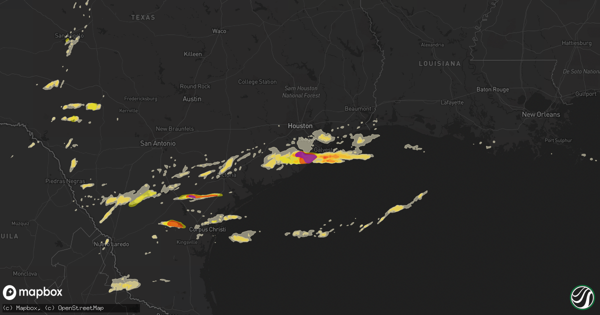
Hail Map on April 17, 2015
Get this storm
April 17 map
$229
one time, instant access
Download today. No call, no setup
Keep the $229
Bought the map and want the full workflow? Apply the entire $229 to a subscription within 7 days. None of it is wasted.
Every map, not just this one
This buys you this map. Subscription and you get every map we run, in the markets you choose from a few cities to whole states to nationwide. Plus real-time alerts the moment a storm fires.
Contact data
Name, contact info, occupancy, even credit band for addresses in the footprint. You go from where it hit to who to call.
Become the source they trust
Unlimited branding weather history reports on demand. You already have the documented answer ready for the property owner, and you are the one who showed up with it.
Property data and RoofTrace estimates
Pull up any address you have got, its value and the exact code rules for that jurisdiction, straight from One Click Code. Then RoofTrace estimates the squares, pitch, and roof value, priced the way you price.
States Impacted by Hail Map on April 17, 2015
Storm reports
Colorado
| Date | Description |
|---|---|
| 04/17/20156:47 PM CDT | Storm produced a rope tornado on the ground for several minutes. |
| 04/17/20155:00 PM CDT | Large shed picked up and blown onto highway 13 during a thunderstorm. |
| 04/17/20154:18 PM CDT | Weak...short-lived landspout tornado. Spotter was 3 miles west of yuma near highway 34...tornado was around 1-2 miles southeast of spotters position. Tornado lasted a m |
Oklahoma
| Date | Description |
|---|---|
| 04/17/201510:55 AM CDT | Also had estimated 55 mph wind gusts. |
Nebraska
| Date | Description |
|---|---|
| 04/16/20159:45 PM CDT | A local report indicates 1.25 inch wind near 3 SE BIG SPRINGS |
| 04/16/20159:30 PM CDT | Quarter size hail covered the ground. |
Texas
| Date | Description |
|---|---|
| 04/17/20156:55 PM CDT | Small tree limbs down...1100 adams street beeville |
| 04/17/20156:50 PM CDT | Multiple power poles down near 1200 ave e beeville |
| 04/17/20156:46 PM CDT | Powerlines and trees down around east claire and north jefferson street. Many areas without power. |
| 04/17/20156:40 PM CDT | Storm spotter measured a 67 mph wind gust 8 miles west of crowley. |
| 04/17/20156:38 PM CDT | Hail reported on southwest side of beeville. |
| 04/17/20156:18 PM CDT | Tree down on bundy road...impassable. Power outages. Cr 215 impassable due to high water. Power outages in eastern part of wharton county. |
| 04/17/20155:58 PM CDT | Trees down on route 283 near morales...estimated 50-60 mph wind gust. |
| 04/17/20155:55 PM CDT | Clemville resident had damage to barn and ac window unit...damage to pump house...numerous trees down in yard. |
| 04/17/20155:07 PM CDT | Large tree limbs blown down at intersection of hwys 87 and 72. Time estimated from radar. |
| 04/17/20154:30 PM CDT | 5 to 6 inch diameter tree limb blown down |
| 04/17/20154:05 PM CDT | Delayed report...two large trees blown down...power pole blown down...and travel trailer blown off road and destroyed |
| 04/17/20154:05 PM CDT | Several large tree limbs blown down. Time estimated from radar. |
| 04/17/20153:27 PM CDT | Fedex driver reported hail along highway 72 |
| 04/17/20153:15 PM CDT | A local report indicates 60 MPH wind near 10 SW TILDEN |
| 04/17/20152:40 PM CDT | A local report indicates 1.00 inch wind near FOWLERTON |
| 04/17/20152:22 PM CDT | Trees snapped or uprooted. |
| 04/17/20151:50 PM CDT | Large tree limbs down and damage to a metal roof at the chapparal wildlife management area. |
| 04/17/20151:43 PM CDT | A local report indicates 1.50 inch wind near 3 N FORT GRIFFIN |
| 04/17/20151:38 PM CDT | A local report indicates 1.00 inch wind near POTOSI |
| 04/17/20151:09 PM CDT | A local report indicates 1.75 inch wind near 2 NE VIEW |
| 04/17/201512:35 PM CDT | A local report indicates 1.25 inch wind near 16 NW ALBANY |
| 04/17/201512:21 PM CDT | A local report indicates 1.00 inch wind near MEDICINE MOUND |
| 04/17/201511:55 AM CDT | A local report indicates 1.00 inch wind near 2 NE WALL |
| 04/17/201511:29 AM CDT | 58 mph wind gust at halstead road near loop 306... On the east side of san angelo. |
| 04/17/201511:27 AM CDT | A local report indicates 1.00 inch wind near 6 SSW SAN ANGELO |
| 04/17/201510:00 AM CDT | A local report indicates 1.00 inch wind near QUANAH |
| 04/16/201510:50 PM CDT | Power poles down |
| 04/16/201510:34 PM CDT | A local report indicates 1.00 inch wind near 1 SE GREGORY |
| 04/16/201510:30 PM CDT | Psbl tornado. Brief touchdown. Damage to fences and house under construction in promenade subdivision. |
| 04/16/201510:21 PM CDT | A local report indicates 60 MPH wind near PORTLAND |
| 04/16/20159:27 PM CDT | Zapata county sheriffs office reported quarter size hail near the city of zapata. |
| 04/16/20159:01 PM CDT | 59 mph tstm wind gust from brazoria wildlife refuge remote automated weather sensor raws. |
| 04/16/20158:48 PM CDT | Johnson space center recorded 82 mph tstm wind gust from 152 ft anemometer...est 65 mph plus at surface...many small trees and tree limbs snapped and blown over in the |
| 04/16/20158:45 PM CDT | Billboard collapsed onto an suv automobile on fm 2351. |
| 04/16/20158:42 PM CDT | Storm chaser reporting tornado on ground. |
| 04/16/20158:40 PM CDT | Estimated 60 mph tstm wind gust during 45-50 mph sustained winds. |
| 04/16/20158:40 PM CDT | Estimated at least 60 mph tstm wind gusts during 45-50 mph sustained winds. Received 2.96 inches in cocorahs raingage. |
| 04/16/20158:39 PM CDT | A local report indicates 62 MPH wind near ALICE |
| 04/16/20158:36 PM CDT | Storm chaser reports tornado touchdown in open field...spotted north of highway 44 just east of alice. |
| 04/16/20158:30 PM CDT | Large tree down along with numerous tree limbs down in nassau bay. |
| 04/16/20158:29 PM CDT | Wind gust of 53 knots measured at houston hobby airport asos. |
| 04/16/20158:29 PM CDT | 61 mph 53 knot thunderstorm wind gust at houston hobby airport. |
| 04/16/20158:15 PM CDT | Tree limbs and power lines down in manvel. |
| 04/16/20158:15 PM CDT | Couple of trees down...one house struck by lightning...2 transformer fires. |
| 04/16/20158:10 PM CDT | Estimated 80 mph tstm wind gusts in jamaica beach...roof blown off of a home. |
| 04/16/20158:05 PM CDT | Report of estimated 72 mph tstm winds 2 miles south of iowa colony. |
| 04/16/20158:05 PM CDT | Quarter sized hail 2 miles south of iowa colony. |
| 04/16/20158:00 PM CDT | Quarter sized hail and 6 inch tree limbs down due to strong tstm winds in angleton. |
| 04/16/20158:00 PM CDT | Quarter sized hail and 6 inch tree limbs down due to strong tstm winds in angleton. |
| 04/16/20157:57 PM CDT | 2 inch hail in danbury at sh 288 along with estimated 70 mph winds. |
| 04/16/20157:55 PM CDT | Ping pong sized hail in lake jackson...many tree limbs and several trees down...localized flooding for several hours after the storm passed...power outages. |
| 04/16/20157:54 PM CDT | A tree fell on a 2 story house destroying much of it...a tree fell on the american legion pavilion...power out to 75 percent of town. |
| 04/16/20157:53 PM CDT | Six power lines down along hwy 35...also minor flooding in west columbia. |
| 04/16/20157:50 PM CDT | Multiple quarter sized hail reports around angleton. |
| 04/16/20157:50 PM CDT | Circus tent collapse at the angleton fairgrounds...police on scene. |
| 04/16/20157:48 PM CDT | Quarter sized hail at oyster creek and landers. |
| 04/16/20157:40 PM CDT | Egg to tennis ball sized hail in angleton. |
| 04/16/20157:05 PM CDT | Clemville resident had damage to barn and ac window unit...damage to pump house...numerous trees down in yard. |
| 04/16/20157:05 PM CDT | Possible brief tornado touchdown in clemville...10 miles west of bay city. |
Arkansas
| Date | Description |
|---|---|
| 04/16/20158:15 PM CDT | A local report indicates 1.00 inch wind near 1 N CENTERTON |
| 04/16/20158:10 PM CDT | A local report indicates 1.25 inch wind near BENTONVILLE |
Kansas
| Date | Description |
|---|---|
| 04/17/20156:55 PM CDT | Location approximated by radar. |
| 04/17/20156:13 PM CDT | A local report indicates a tornado near 12 NNW KALVESTA |
| 04/16/20158:11 PM CDT | A local report indicates 1.50 inch wind near 1 WNW RANSOM |
| 04/16/20158:10 PM CDT | A local report indicates 1.00 inch wind near 3 NNE RANSOM |
| 04/16/20157:33 PM CDT | Hail covering the interstate at this location. |
| 04/16/20157:23 PM CDT | A local report indicates 1.00 inch wind near 6 SSE ARNOLD |
| 04/16/20157:23 PM CDT | A local report indicates 1.00 inch wind near 8 NW NESS CITY |
| 04/16/20157:15 PM CDT | The hail covered the ground. |
| 04/16/20157:13 PM CDT | Report of quarter-sized hail 11 miles north of leoti. Hail fell for several minutes. |
Alabama
| Date | Description |
|---|---|
| 04/17/20156:50 PM CDT | Video relayed via social media by local tv station shows 3/4-1 inch hail in southwestern washington county. Time estimated from radar. |
Cities Impacted by Hail Map on April 17, 2015
- Beeville, TX
- Stockton, KS
- Rocksprings, TX
- Anson, TX
- Hamlin, TX
- Sweetwater, TX
- Brazoria, TX
- Damon, TX
- West Columbia, TX
- Pledger, TX
- Sweeny, TX
- Van Vleck, TX
- Paducah, TX
- Knox City, TX
- Old Glory, TX
- O'Brien, TX
- Seymour, TX
- Altus, OK
- Blair, OK
- Glade, KS
- State Line, MS
- Sonora, TX
- Winona, KS
- Anahuac, TX
- Granbury, TX
- Trent, TX
- Concepcion, TX
- Lake Jackson, TX
- Angleton, TX
- Freeport, TX
- Clute, TX
- Galveston, TX
- Danbury, TX
- Wallace, KS
- Rule, TX
- Aspermont, TX
- Yorktown, TX
- Jourdanton, TX
- Bishop, TX
- Corpus Christi, TX
- Robstown, TX
- Throckmorton, TX
- Bay City, TX
- Boling, TX
- Needville, TX
- Markham, TX
- Guy, TX
- Midfield, TX
- Rosharon, TX
- El Campo, TX
- Wharton, TX
- Wingate, TX
- Quanah, TX
- Orange Grove, TX
- San Diego, TX
- Alice, TX
- Merkel, TX
- Millsap, TX
- Santo, TX
- Aransas Pass, TX
- Portland, TX
- Gregory, TX
- San Angelo, TX
- Victoria, TX
- Houston, TX
- Pasadena, TX
- La Porte, TX
- Seabrook, TX
- Floresville, TX
- Webster, TX
- Friendswood, TX
- Logan, KS
- Inez, TX
- Beeler, KS
- Ransom, KS
- Ness City, KS
- Wakeeney, KS
- Utica, KS
- Quemado, TX
- Rockport, TX
- Cotulla, TX
- George West, TX
- Jayton, TX
- Snyder, TX
- Albany, TX
- Weatherford, TX
- Lipan, TX
- Leoti, KS
- Phillipsburg, KS
- Tilden, TX
- Mineral Wells, TX
- Goliad, TX
- Newcastle, TX
- Graham, TX
- Ogallah, KS
- Ellis, KS
- Carrizo Springs, TX
- Haskell, TX
- Brewster, KS
- Levant, KS
- Colby, KS
- Chunchula, AL
- Wilmer, AL
- Leakesville, MS
- Vinegar Bend, AL
- Perrin, TX
- Jacksboro, TX
- Woodson, TX
- Weinert, TX
- Refugio, TX
- Three Rivers, TX
- Whitsett, TX
- Abilene, TX
- Asherton, TX
- Gaylord, KS
- Alton, KS
- Crowell, TX
- Tivoli, TX
- Inola, OK
- Edna, TX
- Yoakum, TX
- Avoca, TX
- Bentonville, AR
- Bella Vista, AR
- Hiwasse, AR
- Centerton, AR
- Big Wells, TX
- Grove, OK
- South West City, MO
- Westhoff, TX
- Cuero, TX
- Chappell, NE
- Alvin, TX
- Louise, TX
- McCaulley, TX
- Kenedy, TX
- Calliham, TX
- Duke, OK
- Woodston, KS
- Brule, NE
- Big Springs, NE
- Venango, NE
- Edson, KS
- Ingleside, TX
- Taft, TX
- Camp Wood, TX
- Barksdale, TX
- Cimarron, KS
- Jetmore, KS
- Tuscola, TX
- Buffalo Gap, TX
- Garden City, KS
- Missouri City, TX
- Roma, TX
- Zapata, TX
- Falls City, TX
- Stamford, TX
- Laredo, TX
- Fresno, TX
- Crystal City, TX
- Munday, TX
- Hebbronville, TX
- Dighton, KS
- Nordheim, TX
- Brackettville, TX
- Catarina, TX
- Fowlerton, TX
- Encinal, TX
- Hawley, TX
- Christoval, TX
- Eight Mile, AL
- Rio Grande City, TX
- Rowena, TX
- Miles, TX
- Ballinger, TX
- Claremore, OK
- Pleasanton, TX
- Fort Morgan, CO
- Cameron, LA
- Savonburg, KS
- Elsmore, KS
- Sinton, TX
- Karnes City, TX
- Goodfellow Afb, TX
- Hayes Center, NE
- Eldorado, OK
- Ovalo, TX
- Merino, CO
- Wall, TX
- Port Bolivar, TX
- Winters, TX
- Poth, TX
- Bacliff, TX
- Dickinson, TX
- Medina, TX
- Cedar, KS
- Del Rio, TX
- Garwood, TX
- Blackwell, TX
- Sedan, KS
- Theriot, LA
- Eldorado, TX
- Tolar, TX
- Winnie, TX
- Olney, TX
- El Dorado, KS
- Realitos, TX
- Meyersville, TX
- Eagle Pass, TX
- Wiggins, CO
- Campbellton, TX
- Noel, MO
- Hobson, TX
- Lueders, TX
- Bronte, TX
- Norton, TX
- Palisade, NE
- Roby, TX
- Mathis, TX
- Edna, KS
- Bartlett, KS
- Liverpool, TX
- Childress, TX
- Ozona, TX
- Oswego, KS
- Mountain View, OK
- Carnegie, OK
- Hallettsville, TX
- Jay, OK
- Junction, TX
- East Bernard, TX
- Lowell, AR
- Springdale, AR
- Pineville, MO
- Anderson, MO
- Runge, TX
- San Isidro, TX
- Linn, TX
- Freer, TX
- Katy, TX
- Augusta, KS
- League City, TX
- Santa Fe, TX
- Pearland, TX
- Manvel, TX
- Kemah, TX
- Baytown, TX
- Sylvester, TX
- Nolan, TX
- Santa Elena, TX
- Kensington, KS
- Naponee, NE
- Chillicothe, TX