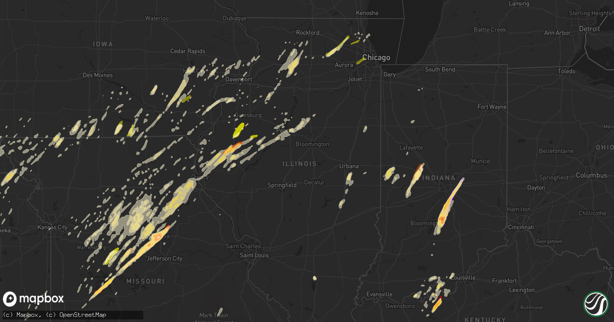
Hail Map in Illinois on April 17, 2013
Get this storm
April 17 map
$229
one time, instant access
Download today. No call, no setup
Keep the $229
Bought the map and want the full workflow? Apply the entire $229 to a subscription within 7 days. None of it is wasted.
Every map, not just this one
This buys you this map. Subscription and you get every map we run, in the markets you choose from a few cities to whole states to nationwide. Plus real-time alerts the moment a storm fires.
Contact data
Name, contact info, occupancy, even credit band for addresses in the footprint. You go from where it hit to who to call.
Become the source they trust
Unlimited branding weather history reports on demand. You already have the documented answer ready for the property owner, and you are the one who showed up with it.
Property data and RoofTrace estimates
Pull up any address you have got, its value and the exact code rules for that jurisdiction, straight from One Click Code. Then RoofTrace estimates the squares, pitch, and roof value, priced the way you price.
Storm reports in Illinois
Illinois
| Date | Description |
|---|---|
| 04/17/20136:58 PM CDT | A local report indicates 77 MPH wind near 4 NE BURTON |
| 04/17/20136:45 PM CDT | 16 to 18 foot long contstruction trailer blown south through the front wall of a staples store. |
| 04/17/20136:45 PM CDT | Roof of bank blown off at 24th and kochs lane. |
| 04/17/20136:12 PM CDT | Significant roof damage to several homes on the south side of town. |
| 04/17/20134:17 PM CDT | A local report indicates 1.00 inch wind near CUBA |
| 04/17/20134:00 PM CDT | Observed at augusta post office. Estimated time. Relayed by coop observer. Corrected location. |
| 04/17/20133:45 PM CDT | A local report indicates 1.25 inch wind near 4 NW BROOKLYN |
| 04/17/20133:40 PM CDT | Pea to quarter size |
| 04/17/20133:26 PM CDT | A local report indicates 1.00 inch wind near ESE BOWEN |
| 04/17/20133:24 PM CDT | A local report indicates 1.00 inch wind near 6 NW CUBA |
| 04/17/20132:55 PM CDT | A local report indicates 1.00 inch wind near 4 WSW MACOMB |
| 04/17/20132:45 PM CDT | Pea to quarter. May be up to half dollar. |
| 04/17/20132:42 PM CDT | A local report indicates 1.00 inch wind near ESE BOWEN |
| 04/17/20131:12 PM CDT | A local report indicates 1.00 inch wind near CRYSTAL LAKE |
| 04/17/201312:14 PM CDT | Time estimated based on radar data. |
| 04/17/201311:35 AM CDT | A local report indicates 1.00 inch wind near 3 NNE HAMPSHIRE |
| 04/17/20137:12 AM CDT | Reported mostly quarters with storm...time estimated from radar. |
| 04/16/20138:46 PM CDT | Relayed via adams county eoc...power out to at least a portion of golden |
| 04/16/20137:53 PM CDT | Carport collapse...reported by clayton fire chief and relayed by adams county ema. |
| 04/16/20137:41 PM CDT | No damage |
| 04/16/20137:41 PM CDT | No damage |
| 04/16/20137:38 PM CDT | Roof collapsed on a 25 foot shed. |
| 04/16/20137:30 PM CDT | Tree damage at quincy airport. |
| 04/16/20137:30 PM CDT | Restaurant damage...details unknown at this time. |
| 04/16/20137:23 PM CDT | Relayed via adams county eoc...est 75-80 mph winds |
| 04/16/20137:15 PM CDT | Near intersection of east 1850th road and illinois route 61. |
| 04/16/20137:14 PM CDT | Street lights blown down at the intersection of 48th and broadway. |
| 04/16/20137:10 PM CDT | A local report indicates 1.00 inch wind near WASHINGTON |
| 04/16/20137:06 PM CDT | A local report indicates 85 MPH wind near COATSBURG |
All States Impacted by Hail Map on April 17, 2013
Cities Impacted by Hail Map on April 17, 2013
- Hale, MO
- Bosworth, MO
- Bogard, MO
- Tina, MO
- West Liberty, IA
- Nichols, IA
- Voss, TX
- Stafford, KS
- Washington, IA
- Crawfordsville, IA
- Lucas, KS
- Tipton, OK
- Snyder, OK
- Frederick, OK
- Camden, IL
- Rushville, IL
- Ipava, IL
- Holliday, MO
- Paloma, IL
- Paris, MO
- Fowler, IL
- Columbia, MO
- Otterville, MO
- Bushnell, IL
- Timewell, IL
- Table Grove, IL
- Colchester, IL
- Hunnewell, MO
- Madison, MO
- Harrisburg, MO
- Philadelphia, MO
- Carthage, IL
- Taylor, MO
- Adair, IL
- Hallsville, MO
- Marietta, IL
- Hannibal, MO
- Cole Camp, MO
- Sturgeon, MO
- Smithton, MO
- Macomb, IL
- Avon, IL
- Thompson, MO
- Ellisville, IL
- Golden, IL
- Bowen, IL
- Boonville, MO
- Palmyra, MO
- Centralia, MO
- Smithfield, IL
- Maywood, MO
- Littleton, IL
- West Point, IL
- Ursa, IL
- Tipton, MO
- Prairie Home, MO
- Stoutsville, MO
- Shelbina, MO
- New Franklin, MO
- Loraine, IL
- Mendon, IL
- Monroe City, MO
- Industry, IL
- Wooldridge, MO
- La Prairie, IL
- Rocheport, MO
- Tennessee, IL
- Huntsville, IL
- Quincy, IL
- Stover, MO
- Clark, MO
- Augusta, IL
- Florence, MO
- Camp Point, IL
- Vermont, IL
- Mora, MO
- Coatsburg, IL
- Fayette, MO
- Bunceton, MO
- Plymouth, IL
- Santa Fe, MO
- Higbee, MO
- Emden, MO
- Syracuse, MO
- La Grange, MO
- Canton, MO
- Unionville, MO
- Blackwater, MO
- Hughesville, MO
- Marshall, MO
- Sedalia, MO
- Nelson, MO
- Irvington, KY
- Guston, KY
- Garfield, KY
- Hudson, KY
- Harned, KY
- Westview, KY
- Rotan, TX
- Hermleigh, TX
- Aspermont, TX
- Lanesville, IN
- Corydon, IN
- Georgetown, IN
- White City, KS
- North Henderson, IL
- Humboldt, NE
- Shawnee, OK
- Clearmont, MO
- Burlington Junction, MO
- Benson, IL
- Minonk, IL
- Carney, OK
- Cresson, TX
- Crowell, TX
- Glen Elder, KS
- Nashville, KS
- Medicine Lodge, KS
- Clifton, KS
- Linn, KS
- Blanchard, OK
- Mattoon, IL
- Humboldt, IL
- Trilla, IL
- Odell, NE
- Luther, OK
- Wellston, OK
- Garden Grove, IA
- Leon, IA
- Davis City, IA
- Oklahoma City, OK
- Norman, OK
- Horton, KS
- Hiawatha, KS
- Clarksville, TN
- Franklin, IN
- Hollis, OK
- Quanah, TX
- Gould, OK
- Mangum, OK
- Maple Park, IL
- Hampshire, IL
- Oakville, IA
- Wapello, IA
- Yarmouth, IA
- Morning Sun, IA
- New Boston, IL
- Joy, IL
- Mediapolis, IA
- Purcell, OK
- Hulbert, OK
- New Palestine, IN
- Fairland, IN
- Greenwood, IN
- Greenfield, IN
- Trafalgar, IN
- Nineveh, IN
- Nashville, IN
- Whiteland, IN
- Bargersville, IN
- Morgantown, IN
- Indianapolis, IN
- Chillicothe, TX
- Minco, OK
- Union City, OK
- Camanche, IA
- Decherd, TN
- Cowan, TN
- Winchester, TN
- Monteagle, TN
- Sewanee, TN
- Prague, OK
- Sparks, OK
- Bartlesville, OK
- Pawhuska, OK
- Cayuga, IN
- Webster, KY
- Comanche, TX
- Mullin, TX
- Armstrong, MO
- California, MO
- Clarksburg, MO
- Auxvasse, MO
- Versailles, MO
- Fortuna, MO
- Lincoln, MO
- Jamestown, MO
- Grant City, MO
- Sheridan, MO
- Worth, MO
- Ravenwood, MO
- Rush Springs, OK
- Ninnekah, OK
- Bevier, MO
- Dawson, NE
- Raymond, KS
- Hudson, KS
- Sylvia, KS
- Russell, KS
- Olmitz, KS
- Hoisington, KS
- Devol, OK
- Grandfield, OK
- Loveland, OK
- Walters, OK
- Ladoga, IN
- Jamestown, IN
- Crawfordsville, IN
- Roachdale, IN
- New Ross, IN
- Centerville, IA
- Cincinnati, IA
- Elgin, OK
- Fletcher, OK
- Apache, OK
- Cyril, OK
- Lawton, OK
- Hopkins, MO
- Dacoma, OK
- Yukon, OK
- El Reno, OK
- La Pryor, TX
- Boggstown, IN
- Columbus, IN
- Needham, IN
- Maxwell, IN
- Norman, IN
- Fountaintown, IN
- Fortville, IN
- Higdon, AL
- Trenton, GA
- Bryant, AL
- Ozona, TX
- Davidson, OK
- Melrose, IA
- Russell, IA
- Lovilia, IA
- Chariton, IA
- Cleveland, OK
- Wellman, IA
- Kalona, IA
- Estill Springs, TN
- Hillsboro, TN
- Mertzon, TX
- Weatherford, TX
- San Angelo, TX
- Robert Lee, TX
- Carlsbad, TX
- Napoleon, MO
- Wellington, MO
- Tecumseh, NE
- Sterling, NE
- Tulsa, OK
- Haviland, KS
- Aurora, KS
- Lindsay, OK
- Eldorado, OK
- Birmingham, IA
- Coldwater, KS
- Indiahoma, OK
- Minneapolis, KS
- Comanche, OK
- Duncan, OK
- Temple, OK
- Randlett, OK
- Huntsville, MO
- Clifton Hill, MO
- Pawnee, OK
- Paden, OK
- Tracy City, TN
- Malta Bend, MO
- Tolono, IL
- Pesotum, IL
- Medicine Park, OK
- Amber, OK
- Anadarko, OK
- Cement, OK
- Verden, OK
- Pocasset, OK
- Tuttle, OK
- Cache, OK
- Chickasha, OK
- Hamilton, IL
- Green Ridge, MO
- Windsor, MO
- Greenleaf, KS
- Barnes, KS
- Monmouth, IL
- Oquawka, IL
- Fort Scott, KS
- Fulton, KS
- Coleman, TX
- Edina, MO
- Novelty, MO
- Clarence, IA
- Tipton, IA
- Villa Grove, IL
- Philo, IL
- Santa Anna, TX
- McKenzie, TN
- Wagoner, OK
- Chouteau, OK
- Wewoka, OK
- Lancing, TN
- Bloomfield, IA
- Eldon, IA
- Ottumwa, IA
- Floris, IA
- Milan, IL
- Haskell, OK
- Riverside, IA
- Mount Sterling, IL
- Center, MO
- New London, MO
- Tell City, IN
- Cannelton, IN
- Watonga, OK
- Kansas, OK
- Rose, OK
- Westville, OK
- Tahlequah, OK
- Proctor, OK
- Locust Grove, OK
- Watts, OK
- Peggs, OK
- Highwood, IL
- Lake Forest, IL
- Highland Park, IL
- Gustine, TX
- Seaton, IL
- Aledo, IL
- Choctaw, OK
- Stillman Valley, IL
- Davis Junction, IL
- Fox River Grove, IL
- Elgin, IL
- Algonquin, IL
- Barrington, IL
- Gilberts, IL
- Dundee, IL
- Carpentersville, IL
- Dekalb, IL
- Saint Charles, IL
- Sycamore, IL
- Cortland, IL
- Gypsum, KS
- Coats, KS
- Depew, OK
- Stroud, OK
- Childress, TX
- Colony, OK
- Carnegie, OK
- Hydro, OK
- Neosho, MO
- Seneca, MO
- Solomon, KS
- Harrah, OK
- Atalissa, IA
- Moscow, IA
- Wilton, IA
- Marquette, KS
- Mcpherson, KS
- Bradley, OK
- Mountain Park, OK
- Alex, OK
- Miami, MO
- Slater, MO
- Cleburne, TX
- Albia, IA
- Moravia, IA
- Sheffield, IL
- Newkirk, OK
- Arkansas City, KS
- Preston, MO
- Cross Timbers, MO
- Menlo, GA
- Chickamauga, GA
- Rising Fawn, GA
- Lenapah, OK
- Delaware, OK
- Flat Rock, AL
- Leaf River, IL
- Mount Morris, IL
- Carter, OK
- Elk City, OK
- Forest City, MO
- Oregon, MO
- White Cloud, KS
- Craig, MO
- Mound City, MO
- Cloverport, KY
- Falls Of Rough, KY
- Gentry, MO
- Stanberry, MO
- Albany, MO
- Pilot Grove, MO
- Lowpoint, IL
- Exline, IA
- Amorita, OK
- Lexington, OK
- Thorntown, IN
- Belvidere, NE
- Bruning, NE
- Flintville, TN
- Elora, TN
- Huntland, TN
- Salisbury, MO
- Porter, OK
- Turon, KS
- Pratt, KS
- Ovalo, TX
- Tuscola, TX
- Wingate, TX
- Towanda, KS
- Franklin Grove, IL
- Dixon, IL
- Amboy, IL
- Spencer, TN
- Table Rock, NE
- Knoxville, IA
- Wayland, IA
- Pickrell, NE
- De Witt, NE
- Eagleville, MO
- Coweta, OK
- Redbird, OK
- Sand Springs, OK
- Sapulpa, OK
- Kellyville, OK
- Hamburg, IA
- Mount Vernon, IL
- Macon, MO
- St John, KS
- Chase, KS
- Lyons, KS
- Sterling, KS
- Plevna, KS
- Alden, KS
- Blakesburg, IA
- Hestand, KY
- Butler, OK
- Canute, OK
- Kellerton, IA
- Morris, OK
- Henryetta, OK
- Okmulgee, OK
- Taloga, OK
- Seymour, TX
- Luray, KS
- Ellsworth, KS
- Kanopolis, KS
- Mauckport, IN
- Central, IN
- Battletown, KY
- Eldena, IL
- Bedford, IA
- New Market, IA
- Braddyville, IA
- Veedersburg, IN
- Covington, IN
- Kingman, IN
- Clarinda, IA
- Great Bend, KS
- Vici, OK
- Oktaha, OK
- Muskogee, OK
- Pikeville, TN
- Sterling City, TX
- Danville, KS
- Alpha, IL
- Ophiem, IL
- Drakesville, IA
- Unionville, IA
- Washington, IL
- Neponset, IL
- Kewanee, IL
- Ruskin, NE
- Hardy, NE
- Mooreland, OK
- Mundelein, IL
- Chillicothe, IL
- Dunlap, IL
- Osceola, MO
- Okemah, OK
- Bristow, OK
- Castle, OK
- Ponca City, OK
- Piggott, AR
- Chattanooga, OK
- Faxon, OK
- Fort Sill, OK
- Geronimo, OK
- Hollister, OK
- Marlow, OK
- Ellinwood, KS
- Bushton, KS
- Lorraine, KS
- Holyrood, KS
- Claflin, KS
- Dover, MO
- Waverly, MO
- Baring, MO
- Brashear, MO
- Greentop, MO
- Kirksville, MO
- Memphis, MO
- Huntingdon, TN
- Noble, OK
- Washington, OK
- Warsaw, MO
- Crescent, OK
- Hitchcock, OK
- Kingfisher, OK
- Maitland, MO
- Graham, MO
- Skidmore, MO
- Chetopa, KS
- Deer Lodge, TN
- Keosauqua, IA
- Palmer, KS
- Protection, KS
- Piedmont, AL
- Henrietta, MO
- Hardin, MO
- Norborne, MO
- Heltonville, IN
- Montrose, MO
- Clinton, MO
- Deepwater, MO
- Appleton City, MO
- Nolan, TX
- Merkel, TX
- Abilene, TX
- Blackwell, TX
- Brighton, IA
- Seminole, OK
- Maud, OK
- Lentner, MO
- Shelbyville, MO
- Mustang, OK
- Luray, MO
- Kahoka, MO
- Powhattan, KS
- Collinsville, AL
- Hanna City, IL
- Peoria, IL
- Edwards, IL
- Brimfield, IL
- Council Hill, OK
- Boynton, OK
- Ohiowa, NE
- Edwardsburg, MI
- Vandalia, MI
- Jones, MI
- Cassopolis, MI
- El Dorado, KS
- Dunbar, NE
- Talmage, NE
- Foss, OK
- Sentinel, OK
- Dill City, OK
- Mereta, TX
- Vernon, TX
- Quincy, MO
- Barnsdall, OK
- Burchard, NE
- Pawnee City, NE
- Lowry City, MO
- Junction City, KS
- Stockport, IA
- Grain Valley, MO
- Blue Springs, MO
- Oak Grove, MO
- Oak, NE
- Nelson, NE
- Edgar, NE
- Fort Cobb, OK
- Maysville, OK
- Pauls Valley, OK
- West Branch, IA
- Iowa City, IA
- Sutter, IL
- Warsaw, IL
- Abingdon, IL
- What Cheer, IA
- Lewisport, KY
- Hawesville, KY
- Martinsville, MO
- Duke, OK
- Northboro, IA
- Decatur, IA
- Lamoni, IA
- Wynona, OK
- Rockville, MO
- Lewistown, IL
- Canton, IL
- Superior, NE
- Epworth, GA
- Long Grove, IA
- De Witt, IA
- Grand Mound, IA
- Donahue, IA
- Fairfield, IA
- Lockridge, IA
- Mount Pleasant, IA
- Maryville, MO
- Barnard, MO
- Bettendorf, IA
- Moline, IL
- Rock Island, IL
- Norwich, KS
- Oregon, IL
- Meriden, KS
- Hoyt, KS
- Topeka, KS
- Talala, OK
- La Plata, MO
- Onaga, KS
- Chelsea, OK
- Claremore, OK
- Brandenburg, KY
- Byers, TX
- Petrolia, TX
- Wichita Falls, TX
- Wayne, OK
- Crossville, TN
- Wickliffe, KY
- La Center, KY
- Signal Mountain, TN
- Whitwell, TN
- Chattanooga, TN
- Ballinger, TX
- Odessa, MO
- Polo, IL
- Rock Falls, IL
- Ashton, IL
- Deer Grove, IL
- Walnut, IL
- Harmon, IL
- Tampico, IL
- Chana, IL
- Ohio, IL
- Wamego, KS
- Saint George, KS
- Westmoreland, KS
- Eureka, IL
- Roanoke, IL
- Leavenworth, IN
- English, IN
- Abilene, KS
- Durant, IA
- Walcott, IA
- Stockton, IA
- Vernon Hills, IL
- Libertyville, IL
- Delphos, KS
- Miltonvale, KS
- Clyde, KS
- Cuba, IL
- Parsons, KS
- Geneseo, KS
- Urich, MO
- Derby, IA
- Humeston, IA
- Brackettville, TX
- Tryon, OK
- Agra, OK
- Chandler, OK
- Buffalo Grove, IL
- Lake Zurich, IL
- Bernie, MO
- Dexter, MO
- Fairfax, OK
- Hominy, OK
- Rhodelia, KY
- Payneville, KY
- Milltown, IN
- Union Star, KY
- Depauw, IN
- Hardinsburg, KY
- Strong City, KS
- Rose Hill, IA
- Delta, IA
- Inman, KS
- Hutchinson, KS
- Lipan, TX
- Carrollton, MO
- West Point, IA
- Promise City, IA
- Seymour, IA
- Blythedale, MO
- Moberly, MO
- Franklin, MO
- Glasgow, MO
- Gilliam, MO
- Cairo, MO
- Lamont, OK
- Enid, OK
- Greencastle, IN
- Bainbridge, IN
- Jay, OK
- Freedom, OK
- Forreston, IL
- Redfield, KS
- Upton, KY
- Sonora, KY
- Magnolia, KY
- Moundridge, KS
- Houstonia, MO
- Burns, KS
- Harper, KS
- Ionia, MO
- Maryneal, TX
- Loraine, TX
- Morganton, GA
- Blue Ridge, GA
- Roseville, IL
- Good Hope, IL
- Sciota, IL
- Derby, IN
- Redding, IA
- Blockton, IA
- Edmond, OK
- Cordell, OK
- Nebraska City, NE
- Collins, MO
- Wheatland, MO
- Edwards, MO
- Mexico, MO
- Marshall, IN
- Bloomingdale, IN
- Lewistown, MO
- Rock Port, MO
- Hurdland, MO
- Lincolnville, KS
- Marion, KS
- Tiffin, IA
- Keota, IA
- Coralville, IA
- Packwood, IA
- Solon, IA
- West Chester, IA
- Batavia, IA
- Oxford, IA
- Richland, IA
- Maramec, OK
- Elmer, OK
- Twin Oaks, OK
- Colcord, OK
- Oaks, OK
- Quemado, TX
- Winters, TX
- Hollenberg, KS
- Belpre, KS
- Alva, OK
- Brownwood, TX
- Marysville, KS
- Albert, KS
- Bunker Hill, KS
- Talmage, KS
- Clinton, IA
- Parnell, MO
- Paint Rock, TX
- Concordia, MO
- Miles, TX
- Sterling, IL
- Jones, OK
- Plano, IA
- Corydon, IA
- Lafayette, IN
- Ripley, OK
- Yale, OK
- Cushing, OK
- Galva, IL
- Buffalo Gap, TX
- Westboro, MO
- Tarkio, MO
- Winfield, KS
- Burden, KS
- Rector, AR
- Glasford, IL
- Kingston Mines, IL
- Mapleton, IL
- Manito, IL
- Adams, NE
- Wann, OK
- Elk Creek, NE
- Peru, NE
- Altus, OK
- Olustee, OK
- Baileyville, KS
- Seneca, KS
- Rowena, TX
- Mannford, OK
- Drumright, OK
- Jennings, OK
- Assaria, KS
- Steinauer, NE
- Lynn Center, IL
- Hillsdale, IN
- Ollie, IA
- Sigourney, IA
- Knob Noster, MO
- Beggs, OK
- Mounds, OK
- Beverly, KS
- Lincoln, KS
- Washington, KS
- Orleans, IN
- Arcola, IL
- Gotebo, OK
- Fairview, KS
- Falls City, NE
- Rulo, NE
- Frankfort, KS
- Liberty, NE
- Manitou Beach, MI
- Adrian, MI
- Clayton, MI
- Onsted, MI
- Mossville, IL
- Mercer, MO
- Lineville, IA
- East Peoria, IL
- Blair, OK
- Lone Wolf, OK
- Higginsville, MO
- Odell, TX
- Rome, IN
- Uniontown, KS
- Sherrard, IL
- Tescott, KS
- Liverpool, IL
- Warrensburg, MO
- Salina, KS
- Brookville, KS
- Creve Coeur, IL
- Morton, IL
- Pekin, IL
- Groveland, IL
- Elmdale, KS
- Denver, MO
- Salina, OK
- Windom, KS
- Weleetka, OK
- Bronte, TX
- Bremen, KS
- Waterville, KS
- Hanover, KS
- Mankato, KS
- Meeker, OK
- Mayetta, KS
- Syracuse, NE
- Hunter, OK
- Hamilton, IA
- Bussey, IA
- Otoe, NE
- Nehawka, NE
- Union, NE
- Lindsborg, KS
- Sulphur, IN
- Wymore, NE
- Oketo, KS
- Whiting, KS
- Atlanta, MO
- Mcloud, OK
- Newalla, OK
- Macomb, OK
- Headrick, OK
- Oklaunion, TX
- Newcastle, OK
- Harrold, TX
- Tecumseh, OK
- Bethany, OK
- Perkins, OK
- Pickering, MO
- Wanette, OK
- Filley, NE
- Orrick, MO
- Larned, KS
- Centerview, MO
- Crescent City, IL
- Milford, IL
- Onarga, IL
- Gilman, IL
- Kirkwood, IL
- Smithshire, IL
- Biggsville, IL
- Brunswick, MO
- De Witt, MO
- Williamstown, MO
- Knox City, MO
- La Belle, MO
- Buffalo, OK
- Dallas City, IL
- Calhoun, MO
- Johnson, NE
- Rothville, MO
- Marceline, MO
- Geneva, NE
- Fairfax, MO
- Wetmore, KS
- Brownville, NE
- Auburn, NE
- Nemaha, NE
- Dawn, MO
- Muscotah, KS
- Laconia, IN
- Ekron, KY
- Ooltewah, TN
- Branchville, IN
- Leopold, IN
- Leeton, MO
- Whiteman Air Force Base, MO
- Chilhowee, MO
- Meadville, MO
- Chillicothe, MO
- Danville, IA
- Weldon, IA
- Van Wert, IA
- Lebanon, IN
- Cherokee, OK
- Arbela, MO
- Santo, TX
- Tipton, MI
- Hudson, MI
- Rock Island, TN
- Mount Ayr, IA
- Ellston, IA
- Grand River, IA
- Valera, TX
- Belleview, MO
- Bixby, MO
- Stella, NE
- Morrowville, KS
- Lewis, KS
- Coffeyville, KS
- Lexington, MO
- Bixby, OK
- Boley, OK
- Broken Arrow, OK
- Paducah, TX
- Byars, OK
- Earlsboro, OK
- Monticello, IN
- Monon, IN
- Beloit, KS
- Cook, NE
- Brock, NE
- Centre, AL
- Darlington, IN
- Brookfield, MO
- Bucklin, MO
- Mountain View, OK
- Blue Springs, NE
- Eldorado, TX
- Diller, NE
- Steele City, NE
- Asher, OK
- Clarence, MO
- Nickerson, KS
- Arcadia, OK
- Mendon, MO
- Wever, IA
- Callao, MO
- New Cambria, MO
- Ethel, MO
- Cambridge, IL
- Willis, MI
- Morganville, KS
- Reelsville, IN
- Colfax, IN
- Bardwell, KY
- Cunningham, KY
- Queen City, MO
- Lancaster, MO
- Glenwood, MO
- Anderson, MO
- Wyandotte, OK
- Cedar Point, KS
- El Dorado Springs, MO
- Stockton, MO
- Rutledge, MO
- Marmaduke, AR
- Lookout Mountain, GA
- Clay Center, KS
- Benton, IA
- Bangs, TX
- Elmer, MO
- Andover, KS
- Mulvane, KS
- Derby, KS
- Augusta, KS
- Rose Hill, KS
- Tonkawa, OK
- Princeville, IL
- Ralston, OK
- Camden, MO
- Winfield, IA
- Ong, NE
- Knox, IN
- Blanket, TX
- Zephyr, TX
- Oswego, KS
- Sperry, OK
- Libertyville, IA
- Manhattan, KS
- Wakefield, KS
- Galva, KS
- Canton, KS
- Arlington, KS
- Rochelle, IL
- Belknap, IL
- Vienna, IL
- Bates City, MO
- Bedford, IN
- Osceola, IA
- Tuscola, IL
- Moulton, IA
- Livonia, MO
- Coatsville, MO
- Toulon, IL
- Speer, IL
- Wyoming, IL
- Sutton, NE
- Shickley, NE
- Kevil, KY
- Terlton, OK
- Gracemont, OK
- New Liberty, IA
- Dixon, IA
- Calamus, IA
- Winigan, MO
- Green Castle, MO
- New Boston, MO
- Sunbright, TN
- Robbins, TN
- Morrison, OK
- Glencoe, OK
- Stillwater, OK
- Rio, IL
- Washburn, IL
- Secor, IL
- Wilmore, KS
- Le Claire, IA
- Centralia, KS
- Corning, KS
- Savonburg, KS
- Novinger, MO
- Saint Francis, AR
- Mineral, IL
- Ainsworth, IA
- Ellis, KS
- Waltonville, IL
- Valley Falls, KS
- Sequatchie, TN
- South Pittsburg, TN
- Astoria, IL
- Belvidere, TN
- Saint Croix, IN
- Benton, KS
- Fort Gibson, OK
- Hunter, KS
- Tipton, KS
- Guthrie, OK
- Little River, KS
- Blackburn, MO
- Alma, MO
- Geneseo, IL
- Hays, KS
- Ewing, MO
- Bethel, MO
- Jacksonville, MO
- Maysville, AR
- Decatur, AR
- Gravette, AR
- Gentry, AR
- Keithsburg, IL
- New London, IA
- Mount Union, IA
- Basco, IL
- Byron, IL
- Guild, TN
- Osage, OK
- Falun, KS
- Barnhart, TX
- Christoval, TX
- Byers, KS
- Matherville, IL
- Inola, OK
- Sweet Springs, MO
- Yates Center, KS
- Sublette, IL
- Kansas City, KS
- Lake City, KS
- Sun City, KS
- Viola, IL
- Goodman, MO
- Vermillion, KS
- Saint Jo, TX
- Forestburg, TX
- Cedartown, GA
- Geary, OK
- Monticello, MO
- Ringwood, OK
- Alexandria, MO
- Saint Patrick, MO
- Fulton, IL
- Berwick, IL
- Beatrice, NE
- Milford, NE
- Corder, MO
- Harvey, IA
- Fremont, IA
- Iuka, KS
- Axtell, KS
- Collinsville, OK
- Dwight, KS
- Sweetwater, TX
- Barneston, NE
- Sabetha, KS
- Morrill, KS
- Robinson, KS
- Highland, KS
- Roosevelt, OK
- Oologah, OK
- Mayview, MO
- Cameron, IL
- Galesburg, IL
- Sidney, IA
- Grove, OK
- Lorton, NE
- Edelstein, IL
- Dana, IL
- Meridian, OK
- McCool Junction, NE
- Goff, KS
- Lacona, IA
- Early, TX
- Columbia, IA
- Donnellson, IA
- Farmington, IA
- Ramona, OK
- Skiatook, OK
- Ochelata, OK
- Altamont, KS
- Muldrow, OK
- Clinton, KY
- Fairmount, IL
- Sparland, IL
- Hennessey, OK
- Du Bois, NE
- Pelham, TN
- Macksville, KS
- Cunningham, KS
- Oneida, TN
- Jamestown, TN
- Ashland, MO
- Camargo, IL
- Virginia, NE
- Hamlin, TX
- Calumet, OK
- Okarche, OK
- Arlington, KY
- Saint Paul, KS
- Wilson, KS
- Havana, KS
- Caney, KS
- Douglas, OK
- Bison, OK
- Reading, KS
- Emporia, KS
- Admire, KS
- Eureka, KS
- Keokuk, IA
- Nauvoo, IL
- Montrose, IA
- Niota, IL
- Paxico, KS
- Prue, OK
- Pleasantville, IA
- Perry, OK
- Hebron, NE
- Madison, KS
- Altona, IL
- Woodhull, IL
- Steward, IL
- Roscoe, TX
- S Coffeyville, OK
- Oxford, KS
- Agency, IA
- Nardin, OK
- Olpe, KS
- Blackwell, OK
- Buhler, KS
- South Hutchinson, KS
- Clarksville, MO
- Wilsey, KS
- Belvue, KS
- Bennett, IA
- Triplett, MO
- Arrow Rock, MO
- Excello, MO
- Dalton, MO
- La Monte, MO
- Keytesville, MO
- Hobart, OK
- La Fayette, IL
- Waveland, IN
- Goldsboro, TX
- Villisca, IA
- Walnut, KS
- Milo, IA
- Northbrook, IL
- Wheeling, IL
- Deerfield, IL
- Glasco, KS
- Essex, IA
- Bennington, KS
- Blanchard, IA
- Elmo, MO
- Lake Village, AR
- Parkdale, AR
- Eudora, AR
- Wilmot, AR
- Bardolph, IL
- Fairview, IL
- Hodgenville, KY
- Cary, IL
- Hoffman Estates, IL
- Arlington Heights, IL
- Palatine, IL
- Oak Brook, IL
- Woodridge, IL
- Hinsdale, IL
- Clarendon Hills, IL
- Broadview, IL
- Hillside, IL
- Westmont, IL
- Downers Grove, IL
- Westchester, IL
- La Grange Park, IL
- Spring City, TN
- Hillsboro, KS
- Kenbridge, VA
- Chase City, VA
- Boydton, VA
- Baskerville, VA
- Dundas, VA
- Rawlings, VA
- Dewitt, VA
- South Hill, VA
- Alberta, VA
- McKenney, VA
- Clarksville, VA
- Charles City, VA
- Prince George, VA
- Henrico, VA
- Petersburg, VA
- Colonial Heights, VA
- Chester, VA
- Hopewell, VA
- Sutherland, VA


