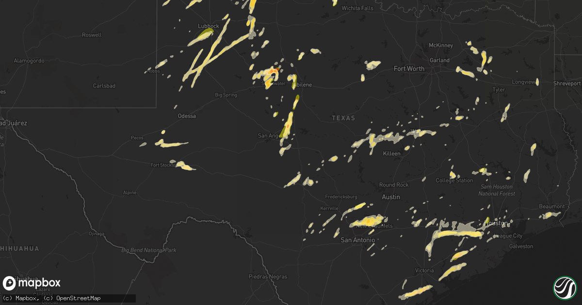
Hail Map in Texas on April 16, 2015
Get this storm
April 16 map
$229
one time, instant access
Download today. No call, no setup
Keep the $229
Bought the map and want the full workflow? Apply the entire $229 to a subscription within 7 days. None of it is wasted.
Every map, not just this one
This buys you this map. Subscription and you get every map we run, in the markets you choose from a few cities to whole states to nationwide. Plus real-time alerts the moment a storm fires.
Contact data
Name, contact info, occupancy, even credit band for addresses in the footprint. You go from where it hit to who to call.
Become the source they trust
Unlimited branding weather history reports on demand. You already have the documented answer ready for the property owner, and you are the one who showed up with it.
Property data and RoofTrace estimates
Pull up any address you have got, its value and the exact code rules for that jurisdiction, straight from One Click Code. Then RoofTrace estimates the squares, pitch, and roof value, priced the way you price.
Storm reports in Texas
Texas
| Date | Description |
|---|---|
| 04/16/20156:55 PM CDT | A local report indicates 1.00 inch wind near IMPERIAL |
| 04/16/20156:47 PM CDT | A local report indicates 2.00 inch wind near KELLERVILLE |
| 04/16/20156:47 PM CDT | A local report indicates 65 MPH wind near KELLERVILLE |
| 04/16/20156:46 PM CDT | A local report indicates 1.75 inch wind near KELLERVILLE |
| 04/16/20156:45 PM CDT | Several trees down |
| 04/16/20156:45 PM CDT | Several trees down |
| 04/16/20156:39 PM CDT | Numerous trees were knocked down in and around the city of van. Some trees fell on homes. |
| 04/16/20156:36 PM CDT | A local report indicates 1.75 inch wind near 5 NW ALLISON |
| 04/16/20156:22 PM CDT | A local report indicates 1.75 inch wind near YANTIS |
| 04/16/20156:22 PM CDT | A local report indicates 1.75 inch wind near YANTIS |
| 04/16/20156:20 PM CDT | Falling tree limbs and roof damage from high winds near 6th st and ave f intersection in markham tx. |
| 04/16/20156:18 PM CDT | A local report indicates 1.00 inch wind near 6 SSW HASKELL |
| 04/16/20156:15 PM CDT | A local report indicates 1.00 inch wind near WINTERS |
| 04/16/20156:03 PM CDT | A local report indicates 1.00 inch wind near 5 WNW BALLINGER |
| 04/16/20155:55 PM CDT | A local report indicates 1.00 inch wind near PAINT ROCK |
| 04/16/20155:51 PM CDT | A local report indicates 1.00 inch wind near STAMFORD |
| 04/16/20155:50 PM CDT | A local report indicates a tornado near 9 N ALLISON |
| 04/16/20155:50 PM CDT | A local report indicates 1.75 inch wind near MONAHANS |
| 04/16/20155:50 PM CDT | Large tree limbs damaged in front of blessing hotel and coffee shop in blessing... Tx. |
| 04/16/20155:48 PM CDT | Hail at least 3 inches in diameter on fm 1268. |
| 04/16/20155:45 PM CDT | A local report indicates 1.00 inch wind near 10 W EDEN |
| 04/16/20155:41 PM CDT | A local report indicates a tornado near 5 S MIAMI |
| 04/16/20155:41 PM CDT | A local report indicates 1.00 inch wind near MONAHANS |
| 04/16/20155:38 PM CDT | A local report indicates 1.75 inch wind near ROWENA |
| 04/16/20155:35 PM CDT | Half dollar sized hail just north of huntsville. |
| 04/16/20155:35 PM CDT | A local report indicates 1.75 inch wind near MATADOR |
| 04/16/20155:30 PM CDT | Golf ball to tennis ball sized hail shattered a skylight on residents home and cracked another between 530 and 545 pm cdt. A recreational vehicle was also damaged. |
| 04/16/20155:29 PM CDT | A local report indicates 1.75 inch wind near 1 N ROSCOE |
| 04/16/20155:24 PM CDT | A local report indicates 1.75 inch wind near MATADOR |
| 04/16/20155:24 PM CDT | 62 mph thunderstorm wind gust measured. |
| 04/16/20155:22 PM CDT | A local report indicates 1.00 inch wind near 1 E LOWAKE |
| 04/16/20155:12 PM CDT | Quarter sized hail in crabbs prairie. |
| 04/16/20155:10 PM CDT | On tx-172 n of 35 and 172 intersection... Recently new electrical pole snapped off 20 feet above the ground leading to power outage. |
| 04/16/20155:10 PM CDT | Huntsville newspaper report of trees down along fm-1696 near crabbs prairie. |
| 04/16/20155:10 PM CDT | Three large oak trees uprooted then landing on homes...other tree limbs broken and wind damage to a half mile stretch of neighborhood. |
| 04/16/20155:10 PM CDT | Quarter size hail reported over the alabama-coushatta reservation. |
| 04/16/20155:09 PM CDT | Ping pong sized hail just northeast of bryan. |
| 04/16/20155:05 PM CDT | On tx-172 n of 35 and 172 intersection... Recently new electrical pole snapped off 20 feet above the ground leading to power outage. |
| 04/16/20155:03 PM CDT | A local report indicates 1.00 inch wind near ROSCOE |
| 04/16/20155:03 PM CDT | Brief tornado reported 6 miles north of interstate 40 west of state highway 70. |
| 04/16/20155:02 PM CDT | A local report indicates 60 MPH wind near 1 W ROBY |
| 04/16/20155:02 PM CDT | Brief tornado reported near hwy 70 south of pampa |
| 04/16/20154:59 PM CDT | A local report indicates 60 MPH wind near 1 W ROBY |
| 04/16/20154:58 PM CDT | Brief tornado reported near hwy 70 south of pampa |
| 04/16/20154:58 PM CDT | Falling at the airport. |
| 04/16/20154:54 PM CDT | A local report indicates 1.00 inch wind near 1 SW PAMPA |
| 04/16/20154:45 PM CDT | A local report indicates 1.00 inch wind near DICKENS |
| 04/16/20154:45 PM CDT | Vost forwarded facebook photo of hail at least 1.75 inch in diameter. |
| 04/16/20154:33 PM CDT | 3 to 4 inch limbs down across northern port lavaca. |
| 04/16/20154:30 PM CDT | Dime to quarter size hail |
| 04/16/20154:30 PM CDT | A local report indicates 1.00 inch wind near 9 ESE PANHANDLE |
| 04/16/20154:29 PM CDT | A local report indicates 2.50 inch wind near 5 ESE PANHANDLE |
| 04/16/20154:28 PM CDT | A local report indicates 1.75 inch wind near 1 S SKELLYTOWN |
| 04/16/20154:17 PM CDT | A local report indicates 1.00 inch wind near 4 ESE PANHANDLE |
| 04/16/20154:15 PM CDT | A local report indicates 1.75 inch wind near 5 NNW SOLMS |
| 04/16/20154:09 PM CDT | A local report indicates 1.00 inch wind near BRONTE |
| 04/16/20154:01 PM CDT | Quarter size hail reported in spring branch. |
| 04/16/20154:00 PM CDT | Large trees knocked down and limbs snapped 3 miles sw of new ulm on shupak road. |
| 04/16/20153:58 PM CDT | A local report indicates 1.75 inch wind near 8 NW ELECTRA |
| 04/16/20153:58 PM CDT | At euclid and 10th. |
| 04/16/20153:54 PM CDT | A local report indicates 1.00 inch wind near PANHANDLE |
| 04/16/20153:52 PM CDT | Reported at 7-11 in harrold |
| 04/16/20153:49 PM CDT | A local report indicates 1.75 inch wind near 19 NNW CODMAN |
| 04/16/20153:47 PM CDT | A local report indicates 1.75 inch wind near 19 NNW CODMAN |
| 04/16/20153:40 PM CDT | A local report indicates 1.50 inch wind near 17 NW CODMAN |
| 04/16/20153:40 PM CDT | Tree limbs down along interstate 10 due to 60 mile per hour wind gusts. |
| 04/16/20153:40 PM CDT | Quarter sized hail along interstate 10 west of columbus. |
| 04/16/20153:37 PM CDT | Golf ball size hail fell near highland park area. |
| 04/16/20153:35 PM CDT | A local report indicates 1.25 inch wind near 5 SW ELECTRA |
| 04/16/20153:35 PM CDT | At county road c and highway 283. |
| 04/16/20153:30 PM CDT | A local report indicates 1.00 inch wind near BLANCO |
| 04/16/20153:29 PM CDT | A local report indicates a tornado near 5 W AUSTWELL |
| 04/16/20153:26 PM CDT | A local report indicates 1.00 inch wind near BLANCO |
| 04/16/20153:25 PM CDT | Interstate 40 and eastern street |
| 04/16/20153:24 PM CDT | Quarter size hail fell near 31st ave and south grand street. |
| 04/16/20153:15 PM CDT | Ping pong ball size hail was falling in northeast amarillo. |
| 04/16/20153:15 PM CDT | Ping pong to golf ball size hail fell near 46th street and washington streets. |
| 04/16/20153:14 PM CDT | At 58th and georgia. |
| 04/16/20153:13 PM CDT | Hail covering highway 759 just east of spearman. |
| 04/16/20153:13 PM CDT | Golf ball size hail was falling at south western st and loop 335. |
| 04/16/20153:12 PM CDT | At interstate 40 and osage. |
| 04/16/20153:11 PM CDT | A local report indicates 1.75 inch wind near 7 ENE AMARILLO |
| 04/16/20153:03 PM CDT | A local report indicates 1.00 inch wind near ROOSEVELT |
| 04/16/20153:00 PM CDT | Golfball sized hail reported at 34th and washington |
| 04/16/20152:59 PM CDT | A local report indicates 1.00 inch wind near 1 W AMARILLO |
| 04/16/20152:58 PM CDT | A local report indicates 1.00 inch wind near 5 N LAKE TANGLEWOOD |
| 04/16/20152:57 PM CDT | A local report indicates 1.00 inch wind near ROOSEVELT |
| 04/16/20152:56 PM CDT | A local report indicates 1.00 inch wind near AMARILLO |
| 04/16/20152:55 PM CDT | Quarter sized hail at 34th and washington |
| 04/16/20152:52 PM CDT | Brief rain wrapped tornado touchdown. Shed in backyard damaged...two trees down. |
| 04/16/20152:50 PM CDT | Hail covering highway 759 just east of spearman. |
| 04/16/20152:34 PM CDT | A local report indicates 1.00 inch wind near GATESVILLE |
| 04/16/20152:30 PM CDT | A local report indicates 1.75 inch wind near REFUGIO |
| 04/16/20152:25 PM CDT | A local report indicates 1.00 inch wind near PANTEX |
| 04/16/20152:20 PM CDT | Hail covering highway 759 just east of spearman. |
| 04/16/20152:16 PM CDT | Brief rope tornado touchdown for 30 seconds. |
| 04/16/20152:15 PM CDT | Dime to quarter size hail with heavy rain in evant |
| 04/16/20151:54 PM CDT | A local report indicates 2.75 inch wind near 5 NE BORGER |
| 04/16/20151:34 PM CDT | Hail as large as quarters reported by goliad sheriff office. |
| 04/16/20151:03 PM CDT | Several tree limbs down...up to 5 feet in length. |
| 04/16/201512:30 PM CDT | Dime size to 1 inch hail reported by the houston pd. |
| 04/16/201512:19 PM CDT | Hail from dine to quarter sized at beltway 8 and clay road. |
| 04/16/201512:15 PM CDT | Numerous reports of quarter size hail. |
| 04/16/201512:15 PM CDT | Quarter sized hail at beltway 8 and bunker hill village. |
| 04/16/201512:52 AM CDT | Quarter size hail at 98th and university |
| 04/16/201512:12 AM CDT | Hail up to golf ball size was falling at the gray county rest area. |
| 04/15/201511:40 PM CDT | A local report indicates 1.75 inch wind near 1 NE PAMPA |
| 04/15/201510:56 PM CDT | A local report indicates 1.00 inch wind near PANHANDLE |
| 04/15/201510:35 PM CDT | Reported by law enforcement near fm 762 and us 59 |
| 04/15/201510:35 PM CDT | Golfball sized hail near fm 762 and us 59. |
| 04/15/201510:20 PM CDT | Trained spotter estimates 60 mile per hour wind gusts. |
| 04/15/201510:20 PM CDT | Hail peaked at quarter sized. |
| 04/15/201510:20 PM CDT | Trained spotter estimates 60 mph gusts |
| 04/15/20159:30 PM CDT | Golfball sized hail in richmond at reading road and fm 762. |
| 04/15/20159:20 PM CDT | Trees down and barn damaged on the east end of cr-272 near the san bernard river. |
| 04/15/20159:15 PM CDT | Pea to quarter size hail |
| 04/15/20159:00 PM CDT | Trees down and barn damaged on the east end of cr-272 near the san bernard river. |
| 04/15/20158:34 PM CDT | Golfball sized hail 3 miles west of altair in central colorado county. |
| 04/15/20158:20 PM CDT | A local report indicates 1.25 inch wind near 4 W O'DONNELL |
| 04/15/20158:18 PM CDT | A local report indicates 1.00 inch wind near WHEELER |
| 04/15/20158:17 PM CDT | Half dollar to ping pong ball size. |
| 04/15/20157:55 PM CDT | Golf ball size hail nearly covering the ground. |
| 04/15/20157:50 PM CDT | From the el campo leader news... Hail damage to agriculture field near intersection of cr-414 and cr-407. |
| 04/15/20157:50 PM CDT | A local report indicates 2.50 inch wind near 2 ENE WHEELER |
| 04/15/20157:49 PM CDT | A local report indicates 1.75 inch wind near WHEELER |
| 04/15/20157:46 PM CDT | On highway 83. |
| 04/15/20157:40 PM CDT | A local report indicates 2.00 inch wind near ROBY |
| 04/15/20157:34 PM CDT | A local report indicates 1.00 inch wind near MCLEAN |
| 04/15/20157:30 PM CDT | Power lines down on highway 43 south of interstate 20. |
| 04/15/20157:30 PM CDT | 208 emerald bay drive bullard tx 75757 |
| 04/15/20157:30 PM CDT | A local report indicates 1.75 inch wind near 4 S ROBY |
| 04/15/20157:30 PM CDT | Several trees downed in and around the wells community. |
| 04/15/20157:26 PM CDT | A local report indicates 1.00 inch wind near TYE |
| 04/15/20157:11 PM CDT | Large trees downed by thunderstorm wind gusts...heavy equipment required to clear them from roadway |
| 04/15/20157:06 PM CDT | A local report indicates 1.75 inch wind near 6 W WHEELER |
| 04/15/20157:06 PM CDT | A local report indicates 1.00 inch wind near 8 NNW ALLISON |
| 04/15/20157:05 PM CDT | A local report indicates 1.00 inch wind near LELIA LAKE |
| 04/15/20157:05 PM CDT | Delayed report. Time estimated from radar |
| 04/15/20157:03 PM CDT | A local report indicates 3.33 inch wind near 2 NE ALLISON |
| 04/15/20157:03 PM CDT | Large trees toppled over by thunderstorms |
| 04/15/20157:00 PM CDT | Quarter-sized hail in andrews. Delayed report from social media |
All States Impacted by Hail Map on April 16, 2015
Cities Impacted by Hail Map on April 16, 2015
- Oglesby, TX
- Durham, OK
- Crawford, OK
- Marion, TX
- Schertz, TX
- Cibolo, TX
- New Braunfels, TX
- Hart, TX
- Boerne, TX
- Borger, TX
- Skellytown, TX
- Pampa, TX
- Imperial, TX
- Grandfalls, TX
- Post, TX
- Hermleigh, TX
- Wheeler, TX
- Tribune, KS
- Syracuse, KS
- Mullinville, KS
- Minneola, KS
- Haviland, KS
- Quitman, TX
- Yantis, TX
- Little River, KS
- Nickerson, KS
- Lyons, KS
- Sterling, KS
- Flomot, TX
- Briscoe, TX
- Huntsville, TX
- Odonnell, TX
- El Campo, TX
- Sayre, OK
- Rosenberg, TX
- Snyder, TX
- Miami, TX
- Panhandle, TX
- Canyon, TX
- Claude, TX
- Amarillo, TX
- Ashland, KS
- Groom, TX
- Macksville, KS
- Vancourt, TX
- San Angelo, TX
- Muleshoe, TX
- Refugio, TX
- Evant, TX
- Lampasas, TX
- Lometa, TX
- Alva, OK
- Freedom, OK
- Troup, TX
- Jacksonville, TX
- Beaumont, TX
- Flatonia, TX
- Muldoon, TX
- San Marcos, TX
- Burrton, KS
- Moundridge, KS
- Menard, TX
- Blanco, TX
- Comfort, TX
- Kendalia, TX
- Partridge, KS
- Arlington, KS
- Reydon, OK
- Amorita, OK
- Burlington, OK
- Cherokee, OK
- Terrell, TX
- Clarendon, TX
- Huntington, TX
- Zavalla, TX
- Coyanosa, TX
- La Grange, TX
- McCaulley, TX
- Sylvester, TX
- Bulverde, TX
- San Antonio, TX
- Isabella, OK
- Halstead, KS
- San Saba, TX
- Seiling, OK
- Kremlin, OK
- Enid, OK
- Pond Creek, OK
- St John, KS
- Mcpherson, KS
- Altus, OK
- Bryan, TX
- Waco, TX
- Riesel, TX
- Spur, TX
- Greensburg, KS
- Lewis, KS
- Shamrock, TX
- Rusk, TX
- Roby, TX
- Perryton, TX
- Balko, OK
- Mingus, TX
- Gordon, TX
- Earth, TX
- Stinnett, TX
- Belpre, KS
- Jayton, TX
- Paint Rock, TX
- Rowena, TX
- Miles, TX
- Ballinger, TX
- Rotan, TX
- Sweetwater, TX
- Hedley, TX
- Deridder, LA
- Gilmer, TX
- Elk City, OK
- Athens, TX
- Headrick, OK
- Beasley, TX
- Richmond, TX
- East Bernard, TX
- Wallis, TX
- Needville, TX
- Taloga, OK
- Leedey, OK
- Canyon Lake, TX
- Spring Branch, TX
- Seminole, TX
- Welch, TX
- Ringwood, OK
- Okeene, OK
- Ames, OK
- Troy, TX
- Moody, TX
- Temple, TX
- Beeville, TX
- Tivoli, TX
- Port Lavaca, TX
- Woodsboro, TX
- Stamford, TX
- Mobeetie, TX
- Winnie, TX
- Groves, TX
- Hamshire, TX
- Port Arthur, TX
- Canadian, TX
- Graford, TX
- Harrold, TX
- Alba, TX
- Bay City, TX
- Midfield, TX
- Blessing, TX
- Palacios, TX
- Lolita, TX
- Matador, TX
- Corsicana, TX
- Barry, TX
- Spearman, TX
- Newton, KS
- Hesston, KS
- Sulphur Springs, TX
- Bandera, TX
- Floydada, TX
- Lubbock, TX
- Meadow, TX
- Brownfield, TX
- Tahoka, TX
- Wilson, TX
- Roscoe, TX
- Windom, KS
- Lindsborg, KS
- Galva, KS
- Junction, TX
- Roosevelt, TX
- Sedgwick, KS
- Dickens, TX
- Hallettsville, TX
- Sylvia, KS
- Plevna, KS
- Gatesville, TX
- Jonesboro, TX
- Lamesa, TX
- Stafford, KS
- Inman, KS
- Hamilton, TX
- Cordell, OK
- Sentinel, OK
- Hobart, OK
- Foss, OK
- Dill City, OK
- Louise, TX
- Mereta, TX
- Norton, TX
- Winters, TX
- Littlefield, TX
- Fairfield, TX
- Roaring Springs, TX
- Quanah, TX
- Protection, KS
- Throckmorton, TX
- Chilton, TX
- Monahans, TX
- New Waverly, TX
- Mooreland, OK
- Carter, OK
- White Deer, TX
- Cheyenne, OK
- Gould, OK
- Dodson, TX
- Willow, OK
- Arnett, OK
- Childress, TX
- Granite, OK
- Mangum, OK
- Mclean, TX
- Vinson, OK
- Wellington, TX
- Lelia Lake, TX
- Erick, OK
- Sweetwater, OK
- Hollis, OK
- Singer, LA
- Waynoka, OK
- Streetman, TX
- Wills Point, TX
- Tomball, TX
- Cypress, TX
- Edgewood, TX
- Canton, TX
- Texola, OK
- Goldthwaite, TX
- Frederick, OK
- Alleyton, TX
- Garwood, TX
- Columbus, TX
- Weimar, TX
- Eagle Lake, TX
- Electra, TX
- Buffalo, OK
- Floresville, TX
- Adkins, TX
- Grand Saline, TX
- Fruitvale, TX
- Katy, TX
- Boling, TX
- Fort Stockton, TX
- Lahoma, OK
- Quail, TX
- Snyder, OK
- Olustee, OK
- Duke, OK
- Eldorado, OK
- Valley Mills, TX
- Levelland, TX
- Crane, TX
- Rosharon, TX
- Pearland, TX
- Manvel, TX
- Alvin, TX
- Mico, TX
- Rule, TX
- Haskell, TX
- Schulenburg, TX
- Natchitoches, LA
- Lockney, TX
- Seguin, TX
- Kingsbury, TX
- Byers, KS
- Hutchinson, KS
- Uvalde, TX
- Hollister, OK
- Aurora, NE
- Sutton, NE
- Girard, TX
- Houston, TX
- Sugar Land, TX
- Stafford, TX
- Bellaire, TX
- Bronte, TX
- Happy, TX
- Coldspring, TX
- Campbell, TX
- Cumby, TX
- Lone Oak, TX
- Montalba, TX
- Iuka, KS
- Pratt, KS
- Buna, TX
- Justiceburg, TX
- Seagraves, TX
- Andrews, TX
- Lorenzo, TX
- Ralls, TX
- Slaton, TX
- Tarzan, TX
- Hearne, TX
- Purmela, TX
- Eola, TX
- Wall, TX
- Commerce, TX
- Orlando, FL
- Hawley, TX
- Merkel, TX
- London, TX
- Bastrop, TX
- Smithville, TX
- Abilene, TX
- Tye, TX
- Carrier, OK
- Goltry, OK
- Oklaunion, TX
- Davidson, OK
- Turon, KS
- Mountain Park, OK
- Nash, OK
- Marquette, KS
- Abbyville, KS
- Hudson, KS
- Alden, KS
- Raymond, KS
- La Vernia, TX
- Marshall, TX
- Tipton, OK
- Mineola, TX
- College Station, TX
- Firth, NE
- Hickman, NE
- Weatherford, TX
- Mineral Wells, TX
- Palo Pinto, TX
- Wharton, TX
- Ganado, TX
- Hale Center, TX
- Hondo, TX
- Pipe Creek, TX
- Hammon, OK
- Butler, OK
- Brenham, TX
- Roosevelt, OK
- Wolfe City, TX
- Greenville, TX
- Emory, TX
- Canute, OK
- Sheridan, TX
- Gonzales, TX
- Buhler, KS
- Holly, CO
- Cherokee, TX
- McGregor, TX
- Utopia, TX
- Vanderpool, TX
- Woodward, OK
- Nashville, KS
- Goliad, TX
- Kosse, TX
- Sharon, OK
- Fargo, OK
- Burton, TX
- Abbott, TX
- Ovalo, TX
- Fieldton, TX
- Olton, TX
- Hamlin, TX
- Palmer, KS
- Greenleaf, KS
- Linn, KS
- Green, KS
- Lakeview, TX
- Cat Spring, TX
- Sealy, TX
- Mcadoo, TX
- Doniphan, NE
- Wood River, NE
- Putnam, OK
- Whiteface, TX
- Itta Bena, MS
- Waterville, KS
- Blue Rapids, KS
- Cunningham, KS
- Deer Park, TX
- Pasadena, TX
- South Houston, TX
- Turkey, TX
- Quitaque, TX
- Medina, TX
- Livingston, TX
- Rosston, OK
- Denver City, TX
- Starkville, MS
- Selden, KS
- Frankston, TX
- Larue, TX
- Juniata, NE
- Lawn, TX
- Sudan, TX
- Dimmitt, TX
- Fort Supply, OK
- Maryneal, TX
- Bedias, TX
- Glen Flora, TX
- D Hanis, TX
- Elmer, OK
- Giddings, TX
- Garden City, KS
- Guy, TX
- Waldron, KS
- Barnes, KS
- Eden, TX
- Eldorado, TX
- Spring, TX
- Ropesville, TX
- Como, TX
- Center Point, TX
- Randolph, KS
- Mexia, TX
- Groesbeck, TX
- Coolidge, TX
- West, TX
- Colorado City, TX
- Springfield, CO
- Hollandale, MS
- Braman, OK
- Mart, TX
- Hardtner, KS
- New Ulm, TX
- Kenesaw, NE
- Red Rock, TX
- Purdon, TX
- Tulia, TX
- Lockhart, TX
- Sonora, TX
- Huffman, TX
- Crosby, TX
- Nazareth, TX
- Aquilla, TX
- Ellinger, TX
- Fayetteville, TX
- Coy, AL
- Blackwell, TX
- Anson, TX
- Brashear, TX
- Hanover, KS
- Bremen, KS
- Voca, TX
- Kinsley, KS
- Victoria, TX
- Wimberley, TX
- Dripping Springs, TX
- Bucklin, KS
- Drummond, OK
- Eddy, TX
- Mason, TX
- Sunflower, MS
- Anahuac, TX
- Woodway, TX
- Hewitt, TX
- Martindale, TX
- Maxwell, TX
- Brady, TX
- Edna, TX
- Fulshear, TX
- Brookshire, TX
- Yoakum, TX
- Frankfort, KS
- Home, KS
- Marysville, KS
- Inez, TX
- Crawford, TX
- Lorena, TX
- Larned, KS
- Meno, OK
- Greenville, MS
- Hobbs, NM
- Copperas Cove, TX
- Custer City, OK
- Jennings, KS
- Geuda Springs, KS
- Rockdale, TX
- Franklin, TX
- Millsap, TX
- Indiahoma, OK
- Baytown, TX
- La Porte, TX
- Longdale, OK
- Canton, OK
- Gate, OK
- Adams, NE
- Stockdale, TX
- Nixon, TX
- Manhattan, KS
- China Spring, TX
- Cache, OK
- Palm Bay, FL
- Fellsmere, FL
- Clifton, TX
- Missouri City, TX
- Waelder, TX
- Goldsmith, TX
- Pecos, TX
- Wortham, TX
- Wolfforth, TX
- Tuscola, TX
- Goessel, KS


