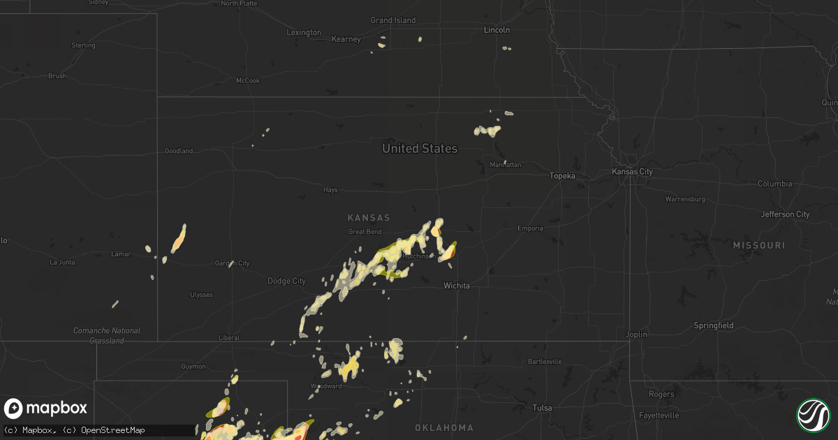
Hail Map in Kansas on April 16, 2015
Get this storm
April 16 map
$229
one time, instant access
Download today. No call, no setup
Keep the $229
Bought the map and want the full workflow? Apply the entire $229 to a subscription within 7 days. None of it is wasted.
Every map, not just this one
This buys you this map. Subscription and you get every map we run, in the markets you choose from a few cities to whole states to nationwide. Plus real-time alerts the moment a storm fires.
Contact data
Name, contact info, occupancy, even credit band for addresses in the footprint. You go from where it hit to who to call.
Become the source they trust
Unlimited branding weather history reports on demand. You already have the documented answer ready for the property owner, and you are the one who showed up with it.
Property data and RoofTrace estimates
Pull up any address you have got, its value and the exact code rules for that jurisdiction, straight from One Click Code. Then RoofTrace estimates the squares, pitch, and roof value, priced the way you price.
Storm reports in Kansas
Kansas
| Date | Description |
|---|---|
| 04/16/20156:05 PM CDT | Delayed report of quarter size hail |
| 04/16/20155:52 PM CDT | Quarter size hail on the north side of mcpherson |
| 04/16/20155:49 PM CDT | A local report indicates 1.75 inch wind near MCPHERSON |
| 04/16/20155:41 PM CDT | Golf ball size hail just south of mcpherson |
| 04/16/20155:04 PM CDT | A local report indicates 1.00 inch wind near TURON |
| 04/16/20155:04 PM CDT | Correction of previous report |
| 04/16/20154:43 PM CDT | A local report indicates 1.00 inch wind near 7 S WINDOM |
| 04/16/20154:27 PM CDT | Delayed report |
| 04/16/20154:22 PM CDT | A local report indicates 1.00 inch wind near NICKERSON |
| 04/16/20154:18 PM CDT | A local report indicates 1.00 inch wind near 1 WSW NEOLA |
| 04/16/20153:55 PM CDT | Multiple reports of quarter sized hail in sterling |
| 04/16/20153:40 PM CDT | The hail covered the ground and stripped leaves from trees. Most stones were pea to nickel-sized. A total of 1.5 inches of rain fell. |
| 04/16/20153:20 PM CDT | A local report indicates 1.00 inch wind near 2 NNE SYLVIA |
| 04/16/20153:15 PM CDT | A local report indicates 1.25 inch wind near 2 WNW TROUSDALE |
| 04/16/20152:47 PM CDT | A local report indicates 1.00 inch wind near 8 NNE STAFFORD |
| 04/16/20152:14 PM CDT | A local report indicates 1.00 inch wind near 4 SE MULLINVILLE |
| 04/16/20152:10 PM CDT | A local report indicates 1.25 inch wind near 4 S SAINT JOHN |
| 04/15/20158:10 PM CDT | A local report indicates 2.50 inch wind near 17 N SYRACUSE |
| 04/15/20158:00 PM CDT | A local report indicates a tornado near 10 N SYRACUSE |
| 04/15/20157:40 PM CDT | Quarter to half dollar |
| 04/15/20157:29 PM CDT | A local report indicates 1.75 inch wind near 3 SSW HESSTON |
| 04/15/20157:18 PM CDT | A local report indicates a tornado near 5 NW SYRACUSE |
All States Impacted by Hail Map on April 16, 2015
Cities Impacted by Hail Map on April 16, 2015
- Oglesby, TX
- Durham, OK
- Crawford, OK
- Marion, TX
- Schertz, TX
- Cibolo, TX
- New Braunfels, TX
- Hart, TX
- Boerne, TX
- Borger, TX
- Skellytown, TX
- Pampa, TX
- Imperial, TX
- Grandfalls, TX
- Post, TX
- Hermleigh, TX
- Wheeler, TX
- Tribune, KS
- Syracuse, KS
- Mullinville, KS
- Minneola, KS
- Haviland, KS
- Quitman, TX
- Yantis, TX
- Little River, KS
- Nickerson, KS
- Lyons, KS
- Sterling, KS
- Flomot, TX
- Briscoe, TX
- Huntsville, TX
- Odonnell, TX
- El Campo, TX
- Sayre, OK
- Rosenberg, TX
- Snyder, TX
- Miami, TX
- Panhandle, TX
- Canyon, TX
- Claude, TX
- Amarillo, TX
- Ashland, KS
- Groom, TX
- Macksville, KS
- Vancourt, TX
- San Angelo, TX
- Muleshoe, TX
- Refugio, TX
- Evant, TX
- Lampasas, TX
- Lometa, TX
- Alva, OK
- Freedom, OK
- Troup, TX
- Jacksonville, TX
- Beaumont, TX
- Flatonia, TX
- Muldoon, TX
- San Marcos, TX
- Burrton, KS
- Moundridge, KS
- Menard, TX
- Blanco, TX
- Comfort, TX
- Kendalia, TX
- Partridge, KS
- Arlington, KS
- Reydon, OK
- Amorita, OK
- Burlington, OK
- Cherokee, OK
- Terrell, TX
- Clarendon, TX
- Huntington, TX
- Zavalla, TX
- Coyanosa, TX
- La Grange, TX
- McCaulley, TX
- Sylvester, TX
- Bulverde, TX
- San Antonio, TX
- Isabella, OK
- Halstead, KS
- San Saba, TX
- Seiling, OK
- Kremlin, OK
- Enid, OK
- Pond Creek, OK
- St John, KS
- Mcpherson, KS
- Altus, OK
- Bryan, TX
- Waco, TX
- Riesel, TX
- Spur, TX
- Greensburg, KS
- Lewis, KS
- Shamrock, TX
- Rusk, TX
- Roby, TX
- Perryton, TX
- Balko, OK
- Mingus, TX
- Gordon, TX
- Earth, TX
- Stinnett, TX
- Belpre, KS
- Jayton, TX
- Paint Rock, TX
- Rowena, TX
- Miles, TX
- Ballinger, TX
- Rotan, TX
- Sweetwater, TX
- Hedley, TX
- Deridder, LA
- Gilmer, TX
- Elk City, OK
- Athens, TX
- Headrick, OK
- Beasley, TX
- Richmond, TX
- East Bernard, TX
- Wallis, TX
- Needville, TX
- Taloga, OK
- Leedey, OK
- Canyon Lake, TX
- Spring Branch, TX
- Seminole, TX
- Welch, TX
- Ringwood, OK
- Okeene, OK
- Ames, OK
- Troy, TX
- Moody, TX
- Temple, TX
- Beeville, TX
- Tivoli, TX
- Port Lavaca, TX
- Woodsboro, TX
- Stamford, TX
- Mobeetie, TX
- Winnie, TX
- Groves, TX
- Hamshire, TX
- Port Arthur, TX
- Canadian, TX
- Graford, TX
- Harrold, TX
- Alba, TX
- Bay City, TX
- Midfield, TX
- Blessing, TX
- Palacios, TX
- Lolita, TX
- Matador, TX
- Corsicana, TX
- Barry, TX
- Spearman, TX
- Newton, KS
- Hesston, KS
- Sulphur Springs, TX
- Bandera, TX
- Floydada, TX
- Lubbock, TX
- Meadow, TX
- Brownfield, TX
- Tahoka, TX
- Wilson, TX
- Roscoe, TX
- Windom, KS
- Lindsborg, KS
- Galva, KS
- Junction, TX
- Roosevelt, TX
- Sedgwick, KS
- Dickens, TX
- Hallettsville, TX
- Sylvia, KS
- Plevna, KS
- Gatesville, TX
- Jonesboro, TX
- Lamesa, TX
- Stafford, KS
- Inman, KS
- Hamilton, TX
- Cordell, OK
- Sentinel, OK
- Hobart, OK
- Foss, OK
- Dill City, OK
- Louise, TX
- Mereta, TX
- Norton, TX
- Winters, TX
- Littlefield, TX
- Fairfield, TX
- Roaring Springs, TX
- Quanah, TX
- Protection, KS
- Throckmorton, TX
- Chilton, TX
- Monahans, TX
- New Waverly, TX
- Mooreland, OK
- Carter, OK
- White Deer, TX
- Cheyenne, OK
- Gould, OK
- Dodson, TX
- Willow, OK
- Arnett, OK
- Childress, TX
- Granite, OK
- Mangum, OK
- Mclean, TX
- Vinson, OK
- Wellington, TX
- Lelia Lake, TX
- Erick, OK
- Sweetwater, OK
- Hollis, OK
- Singer, LA
- Waynoka, OK
- Streetman, TX
- Wills Point, TX
- Tomball, TX
- Cypress, TX
- Edgewood, TX
- Canton, TX
- Texola, OK
- Goldthwaite, TX
- Frederick, OK
- Alleyton, TX
- Garwood, TX
- Columbus, TX
- Weimar, TX
- Eagle Lake, TX
- Electra, TX
- Buffalo, OK
- Floresville, TX
- Adkins, TX
- Grand Saline, TX
- Fruitvale, TX
- Katy, TX
- Boling, TX
- Fort Stockton, TX
- Lahoma, OK
- Quail, TX
- Snyder, OK
- Olustee, OK
- Duke, OK
- Eldorado, OK
- Valley Mills, TX
- Levelland, TX
- Crane, TX
- Rosharon, TX
- Pearland, TX
- Manvel, TX
- Alvin, TX
- Mico, TX
- Rule, TX
- Haskell, TX
- Schulenburg, TX
- Natchitoches, LA
- Lockney, TX
- Seguin, TX
- Kingsbury, TX
- Byers, KS
- Hutchinson, KS
- Uvalde, TX
- Hollister, OK
- Aurora, NE
- Sutton, NE
- Girard, TX
- Houston, TX
- Sugar Land, TX
- Stafford, TX
- Bellaire, TX
- Bronte, TX
- Happy, TX
- Coldspring, TX
- Campbell, TX
- Cumby, TX
- Lone Oak, TX
- Montalba, TX
- Iuka, KS
- Pratt, KS
- Buna, TX
- Justiceburg, TX
- Seagraves, TX
- Andrews, TX
- Lorenzo, TX
- Ralls, TX
- Slaton, TX
- Tarzan, TX
- Hearne, TX
- Purmela, TX
- Eola, TX
- Wall, TX
- Commerce, TX
- Orlando, FL
- Hawley, TX
- Merkel, TX
- London, TX
- Bastrop, TX
- Smithville, TX
- Abilene, TX
- Tye, TX
- Carrier, OK
- Goltry, OK
- Oklaunion, TX
- Davidson, OK
- Turon, KS
- Mountain Park, OK
- Nash, OK
- Marquette, KS
- Abbyville, KS
- Hudson, KS
- Alden, KS
- Raymond, KS
- La Vernia, TX
- Marshall, TX
- Tipton, OK
- Mineola, TX
- College Station, TX
- Firth, NE
- Hickman, NE
- Weatherford, TX
- Mineral Wells, TX
- Palo Pinto, TX
- Wharton, TX
- Ganado, TX
- Hale Center, TX
- Hondo, TX
- Pipe Creek, TX
- Hammon, OK
- Butler, OK
- Brenham, TX
- Roosevelt, OK
- Wolfe City, TX
- Greenville, TX
- Emory, TX
- Canute, OK
- Sheridan, TX
- Gonzales, TX
- Buhler, KS
- Holly, CO
- Cherokee, TX
- McGregor, TX
- Utopia, TX
- Vanderpool, TX
- Woodward, OK
- Nashville, KS
- Goliad, TX
- Kosse, TX
- Sharon, OK
- Fargo, OK
- Burton, TX
- Abbott, TX
- Ovalo, TX
- Fieldton, TX
- Olton, TX
- Hamlin, TX
- Palmer, KS
- Greenleaf, KS
- Linn, KS
- Green, KS
- Lakeview, TX
- Cat Spring, TX
- Sealy, TX
- Mcadoo, TX
- Doniphan, NE
- Wood River, NE
- Putnam, OK
- Whiteface, TX
- Itta Bena, MS
- Waterville, KS
- Blue Rapids, KS
- Cunningham, KS
- Deer Park, TX
- Pasadena, TX
- South Houston, TX
- Turkey, TX
- Quitaque, TX
- Medina, TX
- Livingston, TX
- Rosston, OK
- Denver City, TX
- Starkville, MS
- Selden, KS
- Frankston, TX
- Larue, TX
- Juniata, NE
- Lawn, TX
- Sudan, TX
- Dimmitt, TX
- Fort Supply, OK
- Maryneal, TX
- Bedias, TX
- Glen Flora, TX
- D Hanis, TX
- Elmer, OK
- Giddings, TX
- Garden City, KS
- Guy, TX
- Waldron, KS
- Barnes, KS
- Eden, TX
- Eldorado, TX
- Spring, TX
- Ropesville, TX
- Como, TX
- Center Point, TX
- Randolph, KS
- Mexia, TX
- Groesbeck, TX
- Coolidge, TX
- West, TX
- Colorado City, TX
- Springfield, CO
- Hollandale, MS
- Braman, OK
- Mart, TX
- Hardtner, KS
- New Ulm, TX
- Kenesaw, NE
- Red Rock, TX
- Purdon, TX
- Tulia, TX
- Lockhart, TX
- Sonora, TX
- Huffman, TX
- Crosby, TX
- Nazareth, TX
- Aquilla, TX
- Ellinger, TX
- Fayetteville, TX
- Coy, AL
- Blackwell, TX
- Anson, TX
- Brashear, TX
- Hanover, KS
- Bremen, KS
- Voca, TX
- Kinsley, KS
- Victoria, TX
- Wimberley, TX
- Dripping Springs, TX
- Bucklin, KS
- Drummond, OK
- Eddy, TX
- Mason, TX
- Sunflower, MS
- Anahuac, TX
- Woodway, TX
- Hewitt, TX
- Martindale, TX
- Maxwell, TX
- Brady, TX
- Edna, TX
- Fulshear, TX
- Brookshire, TX
- Yoakum, TX
- Frankfort, KS
- Home, KS
- Marysville, KS
- Inez, TX
- Crawford, TX
- Lorena, TX
- Larned, KS
- Meno, OK
- Greenville, MS
- Hobbs, NM
- Copperas Cove, TX
- Custer City, OK
- Jennings, KS
- Geuda Springs, KS
- Rockdale, TX
- Franklin, TX
- Millsap, TX
- Indiahoma, OK
- Baytown, TX
- La Porte, TX
- Longdale, OK
- Canton, OK
- Gate, OK
- Adams, NE
- Stockdale, TX
- Nixon, TX
- Manhattan, KS
- China Spring, TX
- Cache, OK
- Palm Bay, FL
- Fellsmere, FL
- Clifton, TX
- Missouri City, TX
- Waelder, TX
- Goldsmith, TX
- Pecos, TX
- Wortham, TX
- Wolfforth, TX
- Tuscola, TX
- Goessel, KS


