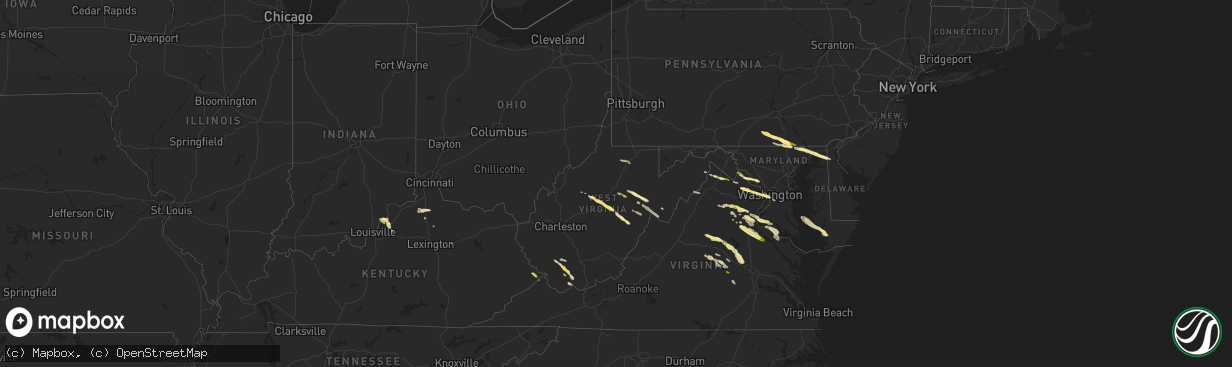
Hail Map in West Virginia on April 15, 2024
The weather event in West Virginia on April 15, 2024 includes Hail, Wind, and Tornado maps. 16 states and 621 cities were impacted and suffered possible damage. The total estimated number of properties impacted is 4,728.
Want more than just the map?
Turn this storm into a full workflow.
- Owner + property data so you know who to knock
- OnDemand branded weather history reports to win the "did we even have hail?" argument
- RoofTrace estimate so reps stop guessing numbers at the door
Bought this map? Upgrade within 7 days and we'll credit the $230. (10-15 min setup call)
Hail
Wind
Tornado
4,728
Estimated number of impacted properties by a 1.00" hail or larger383
Estimated number of impacted properties by a 1.75" hail or larger0
Estimated number of impacted properties by a 2.50" hail or largerStorm reports in West Virginia
West Virginia
| Date | Description |
|---|---|
| 04/15/20244:00 PM CDT | A local report indicates 1.00 inch wind near Flatwoods |
| 04/15/20244:00 PM CDT | Corrects previous hail report from flatwoods. Received picture of hail comparing to a quarter... Which was noticeably larger. |
| 04/15/20243:20 PM CDT | Delayed report. Public reports dime to quarter-sized hail on route 48 at pendleton/pocahontas county line. Time estimated from radar. |
| 04/15/20242:35 PM CDT | Delayed report. Public reports quarter-sized hail in franklin... Wv. |
| 04/15/20242:12 PM CDT | Big tree down blocking whole road... Grassy run rd. Road not passable from either way. Possible line involved... Believed to be a telephone line. |
| 04/15/20241:46 PM CDT | Quarter sized hail with some accumulation. |
| 04/15/202412:30 PM CDT | Tree down near intersection of black oak rd and lower clubhouse dr |
| 04/15/202410:25 AM CDT | Quarter- to half dollar-size hail reported with photo near intersection of jo harry drive and country club rd |
| 04/14/20248:47 PM CDT | A local report indicates 1.00 inch wind near 2 SSE Matoaka |
| 04/14/20247:36 PM CDT | A local report indicates 1.75 inch wind near 2 N Pineville |
| 04/14/20247:36 PM CDT | Hail covering the ground. Golf ball size hail near pineville. Photos received from social media. |
All States Impacted by Hail Map on April 15, 2024
Cities Impacted by Hail Map on April 15, 2024
- Fairmont, WV
- Winchester, VA
- High View, WV
- Berryville, VA
- Stephenson, VA
- Purcellville, VA
- Lovettsville, VA
- Waterford, VA
- Leesburg, VA
- Paeonian Springs, VA
- Dickerson, MD
- Wardensville, WV
- Beallsville, MD
- Poolesville, MD
- Boyds, MD
- Woodstock, VA
- Germantown, MD
- Coalton, WV
- Ellamore, WV
- Gaithersburg, MD
- Middleburg, VA
- Buckhannon, WV
- Carolina, WV
- Farmington, WV
- Worthington, WV
- Mabie, WV
- Norton, WV
- Beverly, WV
- Elkins, WV
- Aldie, VA
- Ashburn, VA
- Sterling, VA
- Glady, WV
- Herndon, VA
- Reston, VA
- Vienna, VA
- Oakton, VA
- Chantilly, VA
- Warrenton, VA
- French Creek, WV
- Tallmansville, WV
- Dunn Loring, VA
- Falls Church, VA
- Arlington, VA
- Adrian, WV
- Horner, WV
- Fort Myer, VA
- Midland, VA
- Catlett, VA
- Street, MD
- Pylesville, MD
- Whiteford, MD
- Washington, DC
- Round Hill, VA
- Bluemont, VA
- Amissville, VA
- Marshall, VA
- Gardners, PA
- Biglerville, PA
- Aspers, PA
- Darlington, MD
- Port Deposit, MD
- Conowingo, MD
- East Berlin, PA
- New Oxford, PA
- York Springs, PA
- Gettysburg, PA
- Abbottstown, PA
- Perryville, MD
- Havre De Grace, MD
- Alexandria, VA
- North East, MD
- Charlestown, MD
- Hanover, PA
- Spring Grove, PA
- Fort Washington, MD
- Temple Hills, MD
- Stafford, VA
- Mill Creek, WV
- Valley Bend, WV
- Elkton, MD
- Chesapeake City, MD
- Middletown, DE
- Nokesville, VA
- Nanjemoy, MD
- Quantico, VA
- Triangle, VA
- Jeffersonton, VA
- Remington, VA
- Parkton, MD
- New Freedom, PA
- White Hall, MD
- Freeland, MD
- Grantsville, WV
- Seven Valleys, PA
- Glen Rock, PA
- Washington, VA
- Barboursville, VA
- Ruckersville, VA
- Welcome, MD
- Charlottesville, VA
- Stewartstown, PA
- Shrewsbury, PA
- Newark, DE
- Normantown, WV
- Circleville, WV
- Bartow, WV
- Arnoldsburg, WV
- Bealeton, VA
- Cedarville, WV
- Gassaway, WV
- Exchange, WV
- Gordonsville, VA
- Rosedale, WV
- King George, VA
- Oxon Hill, MD
- Blue Grass, VA
- Franklin, WV
- Naval Anacost Annex, DC
- Taylors Island, MD
- Madison, MD
- Newburg, MD
- Goldvein, VA
- Fredericksburg, VA
- Railroad, PA
- Dahlgren, VA
- Glenville, PA
- Sumerduck, VA
- Richardsville, VA
- Huttonsville, WV
- Sutton, WV
- Flatwoods, WV
- Colonial Beach, VA
- Issue, MD
- Church Creek, MD
- Louisa, VA
- Woolford, MD
- Durbin, WV
- Spotsylvania, VA
- Lignum, VA
- Elkwood, VA
- Diana, WV
- Cowen, WV
- Fawn Grove, PA
- New Park, PA
- Garden City, TX
- Cobb Island, MD
- Montross, VA
- Cambridge, MD
- Crapo, MD
- Mineral, VA
- Big Spring, TX
- Port Royal, VA
- Woodford, VA
- Rappahannock Academy, VA
- Webster Springs, WV
- Colorado City, TX
- Westbrook, TX
- Vienna, MD
- Keswick, VA
- Nanticoke, MD
- Princess Anne, MD
- Tyaskin, MD
- Slatyfork, WV
- Valley Head, WV
- Bergoo, WV
- Bumpass, VA
- Bivalve, MD
- Palmyra, VA
- Scottsville, VA
- Snyder, TX
- Hermleigh, TX
- Coahoma, TX
- Montpelier, VA
- Bremo Bluff, VA
- Glen Allen, VA
- Quantico, MD
- Rockville, VA
- Beaverdam, VA
- Fork Union, VA
- Columbia, VA
- Goochland, VA
- Kents Store, VA
- Whitman, NE
- Aspermont, TX
- Hermosa, SD
- Sundance, WY
- Beulah, WY
- Sandy Hook, VA
- Gum Spring, VA
- Earlysville, VA
- Old Glory, TX
- Valentine, NE
- Kilgore, NE
- Crookston, NE
- Paducah, TX
- Custer, SD
- Charlestown, IN
- Thermopolis, WY
- Edgemont, SD
- Mullen, NE
- Aladdin, WY
- Belle Fourche, SD
- Wanblee, SD
- Kadoka, SD
- Saint Francis, SD
- Hill City, SD
- Cody, NE
- Cartersville, VA
- Goshen, KY
- Westport, KY
- La Grange, KY
- Newcastle, WY
- Hot Springs, SD
- Rapid City, SD
- Seymour, TX
- Crowell, TX
- Piedmont, SD
- Long Valley, SD
- Black Hawk, SD
- Parmelee, SD
- Keystone, SD
- Spearfish, SD
- Norris, SD
- White River, SD
- Sturgis, SD
- Powhatan, VA
- Quanah, TX
- Box Elder, SD
- Ellsworth Afb, SD
- Wall, SD
- Quinn, SD
- Chillicothe, TX
- Eldorado, OK
- Wood Lake, NE
- Wasta, SD
- Buckner, KY
- Tuthill, SD
- Moseley, VA
- Cyclone, WV
- Philip, SD
- Olustee, OK
- Altus, OK
- Glen Fork, WV
- Brenton, WV
- Pineville, WV
- Jesse, WV
- Oceana, WV
- Matheny, WV
- Elmer, OK
- Davin, WV
- Martin, SD
- Mission, SD
- Crestwood, KY
- Belvidere, SD
- Saulsville, WV
- New Richmond, WV
- Herndon, WV
- Williamstown, KY
- Dry Ridge, KY
- Ransom, KY
- Phelps, KY
- Allen, SD
- Jonesville, KY
- New Underwood, SD
- Owenton, KY
- Wood, SD
- Midland, SD
- Shelbyville, KY
- Simpsonville, KY
- Scenic, SD
- Northfork, WV
- Welch, WV
- Timber Lake, SD
- Fairburn, SD
- Anawalt, WV
- Murdo, SD
- Corinth, KY
- Kimper, KY
- Pinsonfork, KY
- Owanka, SD
- Buffalo Gap, SD
- Hurley, VA
- Draper, SD
- Caputa, SD
- Hanston, KS
- Jetmore, KS
- Falmouth, KY
- Ness City, KS
- Cynthiana, KY
- Sadieville, KY
- Fort Pierre, SD
- Pierre, SD
- Pierce, NE
- Osmond, NE
- Plainview, NE
- Mount Sterling, KY
- Okaton, SD
- Royal, NE
- Winnetoon, NE
- Orchard, NE
- Collyer, KS
- Hoxie, KS
- Creighton, NE
- Verdigre, NE
- Morland, KS
- Quinter, KS
- Bloomfield, NE
- Norton, KS
- Lenora, KS
- Almena, KS
- Chadron, NE
- Long Island, KS
- Prairie View, KS
- Beaver City, NE
- Stamford, NE
- Oxford, NE
- Center, NE
- Hayes, SD
- Dighton, KS
- Montrose, SD
- Ogallah, KS
- Waukomis, OK
- Watonga, OK
- Edison, NE
- Ellis, KS
- Damar, KS
- Stockton, KS
- Arapahoe, NE
- Kingfisher, OK
- Omega, OK
- Loyal, OK
- Humboldt, SD
- Bogue, KS
- Logan, KS
- Phillipsburg, KS
- Glade, KS
- Hoskins, NE
- Norfolk, NE
- Pender, NE
- Walthill, NE
- Enid, OK
- Rosalie, NE
- Salem, SD
- Randolph, NE
- Drummond, OK
- Wakefield, NE
- Wayne, NE
- Niobrara, NE
- Wisner, NE
- Canova, SD
- Winfred, SD
- Winnebago, NE
- Thurston, NE
- Bancroft, NE
- Beemer, NE
- Hunter, OK
- Kremlin, OK
- Hartford, SD
- Burke, SD
- Emerson, NE
- Hubbard, NE
- Avon, SD
- Lamont, OK
- Medford, OK
- Hennessey, OK
- Bison, OK
- Lexington, NE
- Elwood, NE
- Cozad, NE
- Naponee, NE
- Tyndall, SD
- Jackson, NE
- South Sioux City, NE
- Sioux City, IA
- North Sioux City, SD
- Douglas, OK
- Kensington, KS
- Homer, NE
- Jefferson, SD
- Dakota City, NE
- Republican City, NE
- Smith Center, KS
- Riverton, NE
- Wilcox, NE
- Hildreth, NE
- Bloomington, NE
- Franklin, NE
- Holdrege, NE
- Merrill, IA
- Athol, KS
- Inavale, NE
- Lebanon, KS
- Red Cloud, NE
- Campbell, NE
- Bladen, NE
- Upland, NE
- Alva, OK
- Freedom, OK
- Coldwater, KS
- Lake City, KS
- Hornick, IA
- Westfield, IA
- Axtell, NE
- Funk, NE
- Colome, SD
- Winner, SD
- Blue Hill, NE
- Roseland, NE
- Holstein, NE
- Ayr, NE
- Minden, NE
- Sumner, NE
- Eddyville, NE
- Oconto, NE
- Danbury, IA
- Mapleton, IA
- Smithland, IA
- Oto, IA
- Hinton, IA
- Anthon, IA
- Superior, NE
- Lawrence, NE
- Guide Rock, NE
- Glenvil, NE
- Nelson, NE
- Deweese, NE
- Hastings, NE
- Fairfield, NE
- Juniata, NE
- Edgar, NE
- Oak, NE
- Clay Center, NE
- Inland, NE
- Correctionville, IA
- Battle Creek, IA
- Gibbon, NE
- Kearney, NE
- Charter Oak, IA
- Denison, IA
- Eagle Butte, SD
- Davenport, NE
- Harvard, NE
- Trumbull, NE
- Gettysburg, SD
- Ida Grove, IA
- Pleasanton, NE
- Kingsley, IA
- Pierson, IA
- Schleswig, IA
- Otis, KS
- Bison, KS
- Saronville, NE
- Ong, NE
- Carleton, NE
- Kenesaw, NE
- Heartwell, NE
- Riverdale, NE
- Shelton, NE
- Alda, NE
- Wood River, NE
- Doniphan, NE
- Chapman, NE
- Ravenna, NE
- Cairo, NE
- Grand Island, NE
- Phillips, NE
- Loup City, NE
- Hazard, NE
- Dannebrog, NE
- Boelus, NE
- Ashton, NE
- Farwell, NE
- Litchfield, NE
- Saint Libory, NE
- Rockville, NE
- Giltner, NE
- Aurora, NE
- Geneva, NE
- Shickley, NE
- Sutton, NE
- Kennebec, SD
- Wessington Springs, SD
- Bruning, NE
- Strang, NE
- Saint Paul, NE
- Hampton, NE
- Marquette, NE
- Central City, NE
- Henderson, NE
- Grafton, NE
- Palmer, NE
- Elba, NE
- Arcadia, NE
- Scotia, NE
- North Loup, NE
- Archer, NE
- Wolbach, NE
- Ord, NE
- Holstein, IA
- Wessington, SD
- Manilla, IA
- Elk Point, SD
- Cushing, IA
- Corsicana, TX
- Westside, IA
- Vail, IA
- Lebanon, SD
- Fairmont, NE
- McCool Junction, NE
- York, NE
- Bradshaw, NE
- Ohiowa, NE
- Hordville, NE
- Greeley, NE
- Olpe, KS
- Emporia, KS
- Neosho Rapids, KS
- Breda, IA
- Onida, SD
- Kiron, IA
- Deloit, IA
- Tobias, NE
- Exeter, NE
- Milligan, NE
- Clarks, NE
- Polk, NE
- Elyria, NE
- Burwell, NE
- Comstock, NE
- Spalding, NE
- Primrose, NE
- Ericson, NE
- Wall Lake, IA
- Piedmont, KS
- Odebolt, IA
- Lincolnville, KS
- Eureka, KS
- Bartlett, NE
- Beaver Crossing, NE
- Garland, NE
- Crete, NE
- Milford, NE
- Seward, NE
- Malcolm, NE
- Waco, NE
- Dorchester, NE
- Benedict, NE
- Gresham, NE
- Lincoln, NE
- Western, NE
- Utica, NE
- Pleasant Dale, NE
- Stromsburg, NE
- Staplehurst, NE
- Friend, NE
- Goehner, NE
- Cordova, NE
- Denton, NE
- Bee, NE
- Harrold, SD
- Petersburg, NE
- Early, IA
- Lake View, IA
- Highmore, SD
- Holabird, SD
- Storm Lake, IA
- Elgin, NE
- Clearwater, NE
- Alta, IA
- Nemaha, IA
- Sac City, IA
- Lynch, NE
- Newell, IA
- Tolstoy, SD
- Onaka, SD
- Hoven, SD
- Bowdle, SD
- Roscoe, SD
- Albert City, IA
- Neligh, NE
- Burr Oak, KS
- Meadow Grove, NE
- Marathon, IA
- Mankato, KS
- Hazleton, IA
- Fairbank, IA
- Independence, IA
- Reliance, SD
- Lower Brule, SD
- Brunswick, NE
- Oelwein, IA
- Dodge, NE
- Lyons, NE
- West Point, NE
- Onawa, IA
- Ponca, NE
- Lebo, KS
- Oakland, NE
- Carbondale, KS
- Overbrook, KS
- Reading, KS
- Osage City, KS
- Melvern, KS
- Lyndon, KS
- Scranton, KS
- Vassar, KS
- Scribner, NE
- Berryton, KS
- Stanton, NE
- Lecompton, KS
- Howells, NE
- Rogers, NE
- Schuyler, NE
- Clarkson, NE
- Pilger, NE
- Silver Creek, NE
- Delia, KS
- Le Mars, IA
- Capon Bridge, WV
- Maryville, MO


