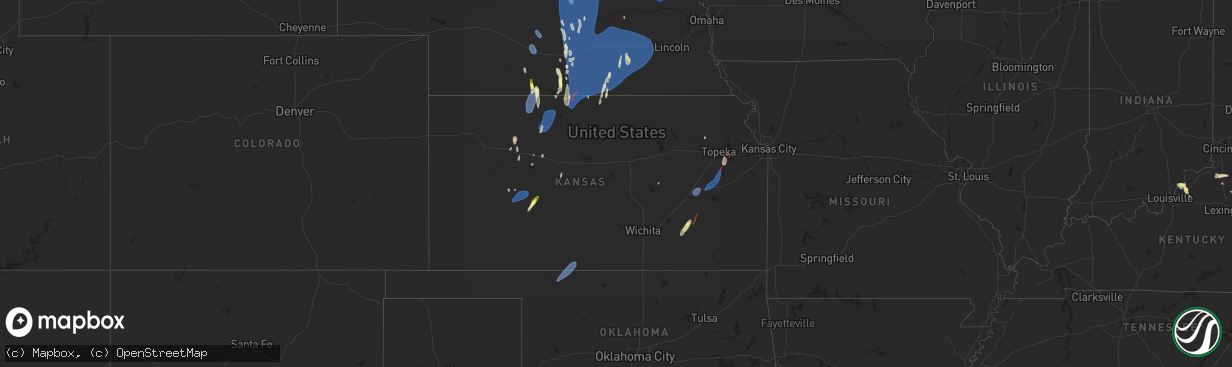
Hail Map in Kansas on April 15, 2024
The weather event in Kansas on April 15, 2024 includes Hail, Wind, and Tornado maps. 16 states and 621 cities were impacted and suffered possible damage. The total estimated number of properties impacted is 137.
Want more than just the map?
Turn this storm into a full workflow.
- Owner + property data so you know who to knock
- OnDemand branded weather history reports to win the "did we even have hail?" argument
- RoofTrace estimate so reps stop guessing numbers at the door
Bought this map? Upgrade within 7 days and we'll credit the $230. (10-15 min setup call)
Hail
Wind
Tornado
137
Estimated number of impacted properties by a 1.00" hail or larger0
Estimated number of impacted properties by a 1.75" hail or larger0
Estimated number of impacted properties by a 2.50" hail or largerStorm reports in Kansas
Kansas
| Date | Description |
|---|---|
| 04/15/20246:27 AM CDT | Storm chaser reported a tornado as it passed through richland. |
| 04/15/20246:17 AM CDT | Storm damage reported in overbrook area by em. Time estimated from radar. |
| 04/15/20246:07 AM CDT | *** 2 inj *** ef1 tornado with estimated 100 mph peak winds. 75 yard width with 9.82 mile path length ending at 6:27 am in richland... Ks. Two injuries sustained when t |
| 04/15/20245:51 AM CDT | Ef1 tornado with estimated 110 mph peak winds. 100 yard width and 3.5 |
| 04/15/20245:51 AM CDT | Ef1 tornado with estimated 110 mph peak winds. 100 yard width and 3.56 mile path length ending at 5:57 am 2 miles wsw of lyndon. Damage to trees and one home that shift |
| 04/15/20244:31 AM CDT | Tornado spotted 2 miles southeast of eureka... Also saw power flashes. Relayed by greenwood county emergency management. |
| 04/15/20243:22 AM CDT | Asos station kemp emporia. |
| 04/15/20242:54 AM CDT | Nws employee staying in phg. |
| 04/15/20242:25 AM CDT | Report of minor outbuilding damage and a flipped rv trailer via facebook. Time estimated from radar. |
| 04/15/20241:54 AM CDT | Corrects location of previous tornado report from 13 n athol. Apparent tornado debris signature developed on kuex radar at this location and time. The tds ended at abou |
| 04/15/20241:54 AM CDT | Apparent tornado debris signature developed on kuex radar at this location and time. The tds ended at about 0205 am cdt in extreme southern franklin county. |
| 04/15/202412:59 AM CDT | A local report indicates 60 MPH wind near 4 NNE Webster State Par |
| 04/15/202412:23 AM CDT | A local report indicates 59 MPH wind near 1 SSW Norton |
| 04/15/202412:20 AM CDT | A local report indicates 1.00 inch wind near 3 W Arnold |
All States Impacted by Hail Map on April 15, 2024
Cities Impacted by Hail Map on April 15, 2024
- Fairmont, WV
- Winchester, VA
- High View, WV
- Berryville, VA
- Stephenson, VA
- Purcellville, VA
- Lovettsville, VA
- Waterford, VA
- Leesburg, VA
- Paeonian Springs, VA
- Dickerson, MD
- Wardensville, WV
- Beallsville, MD
- Poolesville, MD
- Boyds, MD
- Woodstock, VA
- Germantown, MD
- Coalton, WV
- Ellamore, WV
- Gaithersburg, MD
- Middleburg, VA
- Buckhannon, WV
- Carolina, WV
- Farmington, WV
- Worthington, WV
- Mabie, WV
- Norton, WV
- Beverly, WV
- Elkins, WV
- Aldie, VA
- Ashburn, VA
- Sterling, VA
- Glady, WV
- Herndon, VA
- Reston, VA
- Vienna, VA
- Oakton, VA
- Chantilly, VA
- Warrenton, VA
- French Creek, WV
- Tallmansville, WV
- Dunn Loring, VA
- Falls Church, VA
- Arlington, VA
- Adrian, WV
- Horner, WV
- Fort Myer, VA
- Midland, VA
- Catlett, VA
- Street, MD
- Pylesville, MD
- Whiteford, MD
- Washington, DC
- Round Hill, VA
- Bluemont, VA
- Amissville, VA
- Marshall, VA
- Gardners, PA
- Biglerville, PA
- Aspers, PA
- Darlington, MD
- Port Deposit, MD
- Conowingo, MD
- East Berlin, PA
- New Oxford, PA
- York Springs, PA
- Gettysburg, PA
- Abbottstown, PA
- Perryville, MD
- Havre De Grace, MD
- Alexandria, VA
- North East, MD
- Charlestown, MD
- Hanover, PA
- Spring Grove, PA
- Fort Washington, MD
- Temple Hills, MD
- Stafford, VA
- Mill Creek, WV
- Valley Bend, WV
- Elkton, MD
- Chesapeake City, MD
- Middletown, DE
- Nokesville, VA
- Nanjemoy, MD
- Quantico, VA
- Triangle, VA
- Jeffersonton, VA
- Remington, VA
- Parkton, MD
- New Freedom, PA
- White Hall, MD
- Freeland, MD
- Grantsville, WV
- Seven Valleys, PA
- Glen Rock, PA
- Washington, VA
- Barboursville, VA
- Ruckersville, VA
- Welcome, MD
- Charlottesville, VA
- Stewartstown, PA
- Shrewsbury, PA
- Newark, DE
- Normantown, WV
- Circleville, WV
- Bartow, WV
- Arnoldsburg, WV
- Bealeton, VA
- Cedarville, WV
- Gassaway, WV
- Exchange, WV
- Gordonsville, VA
- Rosedale, WV
- King George, VA
- Oxon Hill, MD
- Blue Grass, VA
- Franklin, WV
- Naval Anacost Annex, DC
- Taylors Island, MD
- Madison, MD
- Newburg, MD
- Goldvein, VA
- Fredericksburg, VA
- Railroad, PA
- Dahlgren, VA
- Glenville, PA
- Sumerduck, VA
- Richardsville, VA
- Huttonsville, WV
- Sutton, WV
- Flatwoods, WV
- Colonial Beach, VA
- Issue, MD
- Church Creek, MD
- Louisa, VA
- Woolford, MD
- Durbin, WV
- Spotsylvania, VA
- Lignum, VA
- Elkwood, VA
- Diana, WV
- Cowen, WV
- Fawn Grove, PA
- New Park, PA
- Garden City, TX
- Cobb Island, MD
- Montross, VA
- Cambridge, MD
- Crapo, MD
- Mineral, VA
- Big Spring, TX
- Port Royal, VA
- Woodford, VA
- Rappahannock Academy, VA
- Webster Springs, WV
- Colorado City, TX
- Westbrook, TX
- Vienna, MD
- Keswick, VA
- Nanticoke, MD
- Princess Anne, MD
- Tyaskin, MD
- Slatyfork, WV
- Valley Head, WV
- Bergoo, WV
- Bumpass, VA
- Bivalve, MD
- Palmyra, VA
- Scottsville, VA
- Snyder, TX
- Hermleigh, TX
- Coahoma, TX
- Montpelier, VA
- Bremo Bluff, VA
- Glen Allen, VA
- Quantico, MD
- Rockville, VA
- Beaverdam, VA
- Fork Union, VA
- Columbia, VA
- Goochland, VA
- Kents Store, VA
- Whitman, NE
- Aspermont, TX
- Hermosa, SD
- Sundance, WY
- Beulah, WY
- Sandy Hook, VA
- Gum Spring, VA
- Earlysville, VA
- Old Glory, TX
- Valentine, NE
- Kilgore, NE
- Crookston, NE
- Paducah, TX
- Custer, SD
- Charlestown, IN
- Thermopolis, WY
- Edgemont, SD
- Mullen, NE
- Aladdin, WY
- Belle Fourche, SD
- Wanblee, SD
- Kadoka, SD
- Saint Francis, SD
- Hill City, SD
- Cody, NE
- Cartersville, VA
- Goshen, KY
- Westport, KY
- La Grange, KY
- Newcastle, WY
- Hot Springs, SD
- Rapid City, SD
- Seymour, TX
- Crowell, TX
- Piedmont, SD
- Long Valley, SD
- Black Hawk, SD
- Parmelee, SD
- Keystone, SD
- Spearfish, SD
- Norris, SD
- White River, SD
- Sturgis, SD
- Powhatan, VA
- Quanah, TX
- Box Elder, SD
- Ellsworth Afb, SD
- Wall, SD
- Quinn, SD
- Chillicothe, TX
- Eldorado, OK
- Wood Lake, NE
- Wasta, SD
- Buckner, KY
- Tuthill, SD
- Moseley, VA
- Cyclone, WV
- Philip, SD
- Olustee, OK
- Altus, OK
- Glen Fork, WV
- Brenton, WV
- Pineville, WV
- Jesse, WV
- Oceana, WV
- Matheny, WV
- Elmer, OK
- Davin, WV
- Martin, SD
- Mission, SD
- Crestwood, KY
- Belvidere, SD
- Saulsville, WV
- New Richmond, WV
- Herndon, WV
- Williamstown, KY
- Dry Ridge, KY
- Ransom, KY
- Phelps, KY
- Allen, SD
- Jonesville, KY
- New Underwood, SD
- Owenton, KY
- Wood, SD
- Midland, SD
- Shelbyville, KY
- Simpsonville, KY
- Scenic, SD
- Northfork, WV
- Welch, WV
- Timber Lake, SD
- Fairburn, SD
- Anawalt, WV
- Murdo, SD
- Corinth, KY
- Kimper, KY
- Pinsonfork, KY
- Owanka, SD
- Buffalo Gap, SD
- Hurley, VA
- Draper, SD
- Caputa, SD
- Hanston, KS
- Jetmore, KS
- Falmouth, KY
- Ness City, KS
- Cynthiana, KY
- Sadieville, KY
- Fort Pierre, SD
- Pierre, SD
- Pierce, NE
- Osmond, NE
- Plainview, NE
- Mount Sterling, KY
- Okaton, SD
- Royal, NE
- Winnetoon, NE
- Orchard, NE
- Collyer, KS
- Hoxie, KS
- Creighton, NE
- Verdigre, NE
- Morland, KS
- Quinter, KS
- Bloomfield, NE
- Norton, KS
- Lenora, KS
- Almena, KS
- Chadron, NE
- Long Island, KS
- Prairie View, KS
- Beaver City, NE
- Stamford, NE
- Oxford, NE
- Center, NE
- Hayes, SD
- Dighton, KS
- Montrose, SD
- Ogallah, KS
- Waukomis, OK
- Watonga, OK
- Edison, NE
- Ellis, KS
- Damar, KS
- Stockton, KS
- Arapahoe, NE
- Kingfisher, OK
- Omega, OK
- Loyal, OK
- Humboldt, SD
- Bogue, KS
- Logan, KS
- Phillipsburg, KS
- Glade, KS
- Hoskins, NE
- Norfolk, NE
- Pender, NE
- Walthill, NE
- Enid, OK
- Rosalie, NE
- Salem, SD
- Randolph, NE
- Drummond, OK
- Wakefield, NE
- Wayne, NE
- Niobrara, NE
- Wisner, NE
- Canova, SD
- Winfred, SD
- Winnebago, NE
- Thurston, NE
- Bancroft, NE
- Beemer, NE
- Hunter, OK
- Kremlin, OK
- Hartford, SD
- Burke, SD
- Emerson, NE
- Hubbard, NE
- Avon, SD
- Lamont, OK
- Medford, OK
- Hennessey, OK
- Bison, OK
- Lexington, NE
- Elwood, NE
- Cozad, NE
- Naponee, NE
- Tyndall, SD
- Jackson, NE
- South Sioux City, NE
- Sioux City, IA
- North Sioux City, SD
- Douglas, OK
- Kensington, KS
- Homer, NE
- Jefferson, SD
- Dakota City, NE
- Republican City, NE
- Smith Center, KS
- Riverton, NE
- Wilcox, NE
- Hildreth, NE
- Bloomington, NE
- Franklin, NE
- Holdrege, NE
- Merrill, IA
- Athol, KS
- Inavale, NE
- Lebanon, KS
- Red Cloud, NE
- Campbell, NE
- Bladen, NE
- Upland, NE
- Alva, OK
- Freedom, OK
- Coldwater, KS
- Lake City, KS
- Hornick, IA
- Westfield, IA
- Axtell, NE
- Funk, NE
- Colome, SD
- Winner, SD
- Blue Hill, NE
- Roseland, NE
- Holstein, NE
- Ayr, NE
- Minden, NE
- Sumner, NE
- Eddyville, NE
- Oconto, NE
- Danbury, IA
- Mapleton, IA
- Smithland, IA
- Oto, IA
- Hinton, IA
- Anthon, IA
- Superior, NE
- Lawrence, NE
- Guide Rock, NE
- Glenvil, NE
- Nelson, NE
- Deweese, NE
- Hastings, NE
- Fairfield, NE
- Juniata, NE
- Edgar, NE
- Oak, NE
- Clay Center, NE
- Inland, NE
- Correctionville, IA
- Battle Creek, IA
- Gibbon, NE
- Kearney, NE
- Charter Oak, IA
- Denison, IA
- Eagle Butte, SD
- Davenport, NE
- Harvard, NE
- Trumbull, NE
- Gettysburg, SD
- Ida Grove, IA
- Pleasanton, NE
- Kingsley, IA
- Pierson, IA
- Schleswig, IA
- Otis, KS
- Bison, KS
- Saronville, NE
- Ong, NE
- Carleton, NE
- Kenesaw, NE
- Heartwell, NE
- Riverdale, NE
- Shelton, NE
- Alda, NE
- Wood River, NE
- Doniphan, NE
- Chapman, NE
- Ravenna, NE
- Cairo, NE
- Grand Island, NE
- Phillips, NE
- Loup City, NE
- Hazard, NE
- Dannebrog, NE
- Boelus, NE
- Ashton, NE
- Farwell, NE
- Litchfield, NE
- Saint Libory, NE
- Rockville, NE
- Giltner, NE
- Aurora, NE
- Geneva, NE
- Shickley, NE
- Sutton, NE
- Kennebec, SD
- Wessington Springs, SD
- Bruning, NE
- Strang, NE
- Saint Paul, NE
- Hampton, NE
- Marquette, NE
- Central City, NE
- Henderson, NE
- Grafton, NE
- Palmer, NE
- Elba, NE
- Arcadia, NE
- Scotia, NE
- North Loup, NE
- Archer, NE
- Wolbach, NE
- Ord, NE
- Holstein, IA
- Wessington, SD
- Manilla, IA
- Elk Point, SD
- Cushing, IA
- Corsicana, TX
- Westside, IA
- Vail, IA
- Lebanon, SD
- Fairmont, NE
- McCool Junction, NE
- York, NE
- Bradshaw, NE
- Ohiowa, NE
- Hordville, NE
- Greeley, NE
- Olpe, KS
- Emporia, KS
- Neosho Rapids, KS
- Breda, IA
- Onida, SD
- Kiron, IA
- Deloit, IA
- Tobias, NE
- Exeter, NE
- Milligan, NE
- Clarks, NE
- Polk, NE
- Elyria, NE
- Burwell, NE
- Comstock, NE
- Spalding, NE
- Primrose, NE
- Ericson, NE
- Wall Lake, IA
- Piedmont, KS
- Odebolt, IA
- Lincolnville, KS
- Eureka, KS
- Bartlett, NE
- Beaver Crossing, NE
- Garland, NE
- Crete, NE
- Milford, NE
- Seward, NE
- Malcolm, NE
- Waco, NE
- Dorchester, NE
- Benedict, NE
- Gresham, NE
- Lincoln, NE
- Western, NE
- Utica, NE
- Pleasant Dale, NE
- Stromsburg, NE
- Staplehurst, NE
- Friend, NE
- Goehner, NE
- Cordova, NE
- Denton, NE
- Bee, NE
- Harrold, SD
- Petersburg, NE
- Early, IA
- Lake View, IA
- Highmore, SD
- Holabird, SD
- Storm Lake, IA
- Elgin, NE
- Clearwater, NE
- Alta, IA
- Nemaha, IA
- Sac City, IA
- Lynch, NE
- Newell, IA
- Tolstoy, SD
- Onaka, SD
- Hoven, SD
- Bowdle, SD
- Roscoe, SD
- Albert City, IA
- Neligh, NE
- Burr Oak, KS
- Meadow Grove, NE
- Marathon, IA
- Mankato, KS
- Hazleton, IA
- Fairbank, IA
- Independence, IA
- Reliance, SD
- Lower Brule, SD
- Brunswick, NE
- Oelwein, IA
- Dodge, NE
- Lyons, NE
- West Point, NE
- Onawa, IA
- Ponca, NE
- Lebo, KS
- Oakland, NE
- Carbondale, KS
- Overbrook, KS
- Reading, KS
- Osage City, KS
- Melvern, KS
- Lyndon, KS
- Scranton, KS
- Vassar, KS
- Scribner, NE
- Berryton, KS
- Stanton, NE
- Lecompton, KS
- Howells, NE
- Rogers, NE
- Schuyler, NE
- Clarkson, NE
- Pilger, NE
- Silver Creek, NE
- Delia, KS
- Le Mars, IA
- Capon Bridge, WV
- Maryville, MO


