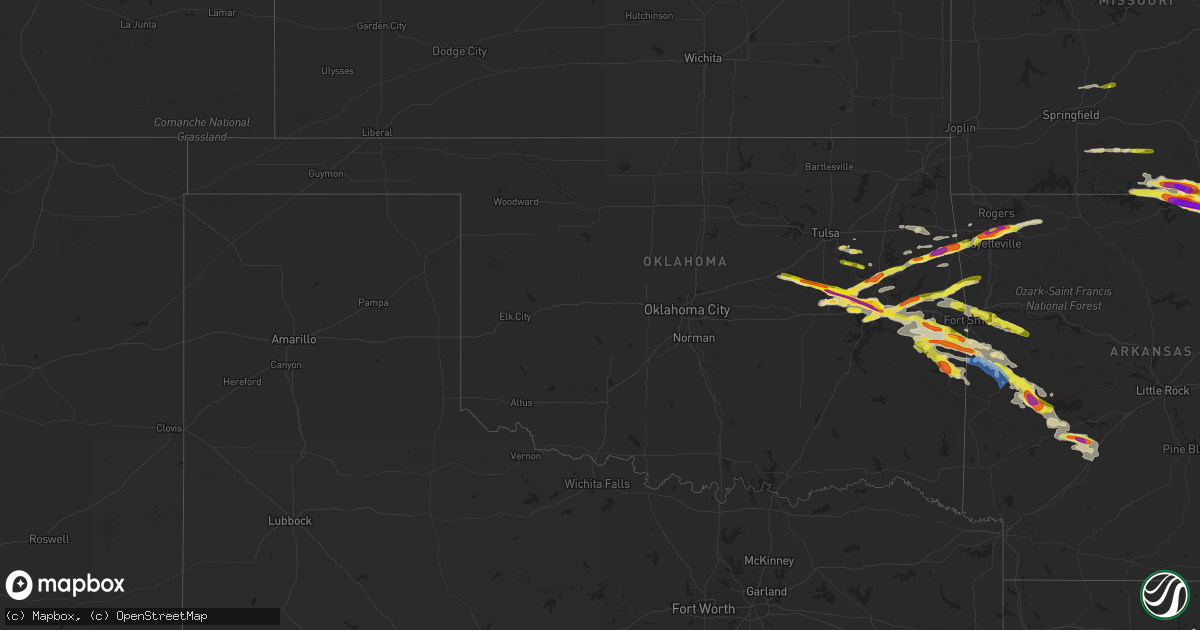
Hail Map in Oklahoma on April 15, 2022
Get this storm
April 15 map
$229
one time, instant access
Download today. No call, no setup
Keep the $229
Bought the map and want the full workflow? Apply the entire $229 to a subscription within 7 days. None of it is wasted.
Every map, not just this one
This buys you this map. Subscription and you get every map we run, in the markets you choose from a few cities to whole states to nationwide. Plus real-time alerts the moment a storm fires.
Contact data
Name, contact info, occupancy, even credit band for addresses in the footprint. You go from where it hit to who to call.
Become the source they trust
Unlimited branding weather history reports on demand. You already have the documented answer ready for the property owner, and you are the one who showed up with it.
Property data and RoofTrace estimates
Pull up any address you have got, its value and the exact code rules for that jurisdiction, straight from One Click Code. Then RoofTrace estimates the squares, pitch, and roof value, priced the way you price.
Storm reports in Oklahoma
Oklahoma
| Date | Description |
|---|---|
| 04/15/202210:48 AM CDT | A local report indicates 2.00 inch wind near 2 N OKMULGEE |
| 04/15/20226:58 AM CDT | At 1157 PM CDT, a severe thunderstorm was located 3 miles northwest of Stonebluff, moving east at 15 mph. HAZARD...60 mph wind gusts and quarter size hail. SOURCE...Radar indicated. IMPACT...Hail damage to vehicles is expected. Expect wind damage to roofs, siding, and trees. Locations in or near the path include... Broken Arrow... Coweta... Haskell... Porter... Taft... Stonebluff... Redbird... Leonard... Choska... |
| 04/15/20226:51 AM CDT | Between 91st and 101st off lynn lane. |
| 04/15/20226:47 AM CDT | A local report indicates 1.00 inch wind near 2 NNE COWETA |
| 04/15/20226:27 AM CDT | At 1126 PM CDT, a severe thunderstorm was located near Council Hill, moving east at 30 mph. HAZARD...Ping pong ball size hail and 60 mph wind gusts. SOURCE...Radar indicated. IMPACT...People and animals outdoors will be injured. Expect hail damage to roofs, siding, windows, and vehicles. Expect wind damage to roofs, siding, and trees. Locations in or near the path include... Checotah... Warner... Porum... Webbers Falls... Oktaha... Rentiesville... Wainwright... This includes Interstate 40 in Oklahoma between mile markers 262 and287. |
| 04/15/20225:52 AM CDT | At 1052 PM CDT, a severe thunderstorm was located near Morris, moving east at 35 mph. HAZARD...Ping pong ball size hail and 60 mph wind gusts. SOURCE...Radar indicated. IMPACT...People and animals outdoors will be injured. Expect hail damage to roofs, siding, windows, and vehicles. Expect wind damage to roofs, siding, and trees. Locations in or near the path include... Okmulgee... Checotah... Morris... Oktaha... Boynton... Council Hill... Rentiesville... Wainwright... Hitchita... Eram... Onapa... This includes Interstate 40 in Oklahoma between mile markers 255 and266. |
| 04/15/20225:44 AM CDT | At 1044 PM CDT, a severe thunderstorm was located 3 miles northeast of Council Hill, moving east at 35 mph. HAZARD...60 mph wind gusts and quarter size hail. SOURCE...Radar indicated. IMPACT...Hail damage to vehicles is expected. Expect wind damage to roofs, siding, and trees. Locations in or near the path include... Warner... Webbers Falls... Oktaha... Boynton... Council Hill... Rentiesville... Keefeton... Wainwright...This includes Interstate 40 in Oklahoma between mile markers 268 and283. |
| 04/15/20225:11 AM CDT | At 1011 PM CDT, a severe thunderstorm was located 4 miles south of Slick, moving east at 35 mph. HAZARD...60 mph wind gusts and half dollar size hail. SOURCE...Radar indicated. IMPACT...Hail damage to vehicles is expected. Expect wind damage to roofs, siding, and trees. Locations in or near the path include... Okmulgee... Morris... Beggs... Schulter... Slick... Preston... Okmulgee State Park... |
| 04/15/20224:56 AM CDT | At 956 PM CDT, a severe thunderstorm was located near Preston, moving east at 50 mph. HAZARD...60 mph wind gusts and half dollar size hail. SOURCE...Radar indicated. IMPACT...Hail damage to vehicles is expected. Expect wind damage to roofs, siding, and trees. Locations in or near the path include... Okmulgee... Morris... Beggs... Boynton... Council Hill... Preston... Bald Hill... Wainwright... Hitchita... Eram...This includes Interstate 40 in Oklahoma between mile markers 258 and262. |
| 04/15/20224:11 AM CDT | At 911 PM CDT, a severe thunderstorm was located 3 miles southeast of Depew, moving east at 35 mph. HAZARD...60 mph wind gusts and quarter size hail. SOURCE...Radar indicated. IMPACT...Hail damage to vehicles is expected. Expect wind damage to roofs, siding, and trees. Locations in or near the path include... Okmulgee... Bristow... Beggs... Depew... Slick... Preston... Okmulgee State Park... This includes Interstate 44 between mile markers 183 and 191. |
| 04/15/20224:06 AM CDT | A local report indicates 1.00 inch wind near HEAVENER |
| 04/15/20223:20 AM CDT | Time estimated by radar. |
| 04/15/20223:19 AM CDT | A local report indicates 1.00 inch wind near 2 NNW WESTVILLE |
| 04/15/20222:43 AM CDT | Storm chaser report relayed through broadcast media. |
| 04/15/20221:37 AM CDT | A local report indicates 1.00 inch wind near 1 ESE WARNER |
| 04/15/202212:00 AM CDT | Relayed from broadcast media tracker. |
| 04/14/202211:46 PM CDT | A local report indicates 1.00 inch wind near 2 N CHECOTAH |
| 04/14/202211:36 PM CDT | Corrects previous hail report from 2 sw rentiesville. Pic via twitter. |
| 04/14/202211:20 PM CDT | Picture via social media from broadcast media storm tracker. |
| 04/14/202211:00 PM CDT | A local report indicates 1.00 inch wind near MORRIS |
| 04/14/202210:45 PM CDT | Picture via social media. |
| 04/14/202210:45 PM CDT | Pictures relayed by broadcast media chaser. |
| 04/14/202210:29 PM CDT | Report relayed by media chaser. |
| 04/14/20229:50 PM CDT | Picture via twitter and on broadcast news. |
| 04/14/20229:50 PM CDT | A local report indicates 1.25 inch wind near 5 SW BEGGS |
| 04/14/20229:21 PM CDT | A local report indicates 1.00 inch wind near 6 S BRISTOW |
| 04/14/20229:21 PM CDT | Corrects previous hail report from 5 s bristow. Report relayed through broadcast media. 1.25 inch hail reported on ok-48 s of bristow. |
| 04/14/20229:21 PM CDT | Report relayed through broadcast media. |
| 04/14/20229:05 PM CDT | Time estimated from radar. |
All States Impacted by Hail Map on April 15, 2022
Cities Impacted by Hail Map on April 15, 2022
- Aliceville, AL
- Greensboro, AL
- Marion, AL
- Brent, AL
- Boligee, AL
- Akron, AL
- Newbern, AL
- Autaugaville, AL
- Moundville, AL
- Jones, AL
- Prattville, AL
- Knoxville, AL
- Eutaw, AL
- Selma, AL
- Osceola, AR
- Houlka, MS
- Pontotoc, MS
- Red Level, AL
- Evergreen, AL
- Andalusia, AL
- Sallisaw, OK
- Hernando, MS
- Cherokee Village, AR
- Ash Flat, AR
- Hardy, AR
- Mammoth Spring, AR
- Paragould, AR
- Brookland, AR
- Jonesboro, AR
- Philadelphia, MS
- Broken Arrow, OK
- Hamilton, MS
- Salem, AR
- Whiteville, TN
- Bolivar, TN
- Henderson, TN
- Stanton, TN
- Somerville, TN
- Toone, TN
- Mason, TN
- Medon, TN
- Hornsby, TN
- Selmer, TN
- Bethel Springs, TN
- Glencoe, AR
- Mansfield, AR
- Tahlequah, OK
- Welling, OK
- Southaven, MS
- Michigan City, MS
- Lamar, MS
- Olive Branch, MS
- Red Banks, MS
- Holly Springs, MS
- Moscow, TN
- Byhalia, MS
- Rossville, TN
- Tecumseh, MO
- Bakersfield, MO
- Lake City, AR
- Oakland, AR
- Caraway, AR
- Powhatan, AR
- Leachville, AR
- Manila, AR
- Burlison, TN
- West Plains, MO
- Caulfield, MO
- Clarkridge, AR
- Keiser, AR
- Poughkeepsie, AR
- Hardenville, MO
- Black Oak, AR
- Gamaliel, AR
- Etowah, AR
- Gainesville, MO
- Udall, MO
- Pocahontas, AR
- Walnut Ridge, AR
- Pontiac, MO
- Portia, AR
- Williford, AR
- Bay, AR
- Moody, MO
- Ravenden, AR
- Ravenden Springs, AR
- Henderson, AR
- Mountain Home, AR
- Monette, AR
- Dora, MO
- Sturkie, AR
- Black Rock, AR
- Gepp, AR
- Alicia, AR
- State University, AR
- Bono, AR
- Imboden, AR
- Camp, AR
- Henning, TN
- Smithville, AR
- Viola, AR
- Hoxie, AR
- Columbia, MS
- Lumberton, MS
- Forsyth, MO
- Chadwick, MO
- Garrison, MO
- Ava, MO
- Squires, MO
- Ozark, MO
- Oldfield, MO
- Fort Gibson, OK
- Hackett, AR
- Mccurtain, OK
- Haskell, OK
- Bokoshe, OK
- Henryetta, OK
- Depew, OK
- Cameron, OK
- Oktaha, OK
- Stigler, OK
- Poteau, OK
- Porum, OK
- Webbers Falls, OK
- Pocola, OK
- Vian, OK
- Warner, OK
- Council Hill, OK
- Morris, OK
- Keota, OK
- Okmulgee, OK
- Boynton, OK
- Spiro, OK
- Eufaula, OK
- Shady Point, OK
- Checotah, OK
- Huntington, AR
- Muskogee, OK
- Gore, OK
- Bristow, OK
- Beggs, OK
- Muldrow, OK
- Greenwood, AR
- Russellville, AL
- Town Creek, AL
- Bassfield, MS
- Sumrall, MS
- Hattiesburg, MS
- Rose, OK
- Amity, AR
- Bonnerdale, AR
- Pearcy, AR
- Arkadelphia, AR
- Bismarck, AR
- Athens, AL
- Hindsville, AR
- Fayetteville, AR
- Springdale, AR
- Watts, OK
- Kansas, OK
- Westville, OK
- Booneville, AR
- Stilwell, OK
- Thaxton, MS
- Oxford, MS
- Hulbert, OK
- Waldron, AR
- Florence, MS
- Harrisville, MS
- Natural Dam, AR
- Nesbit, MS
- Saulsbury, TN
- Middleton, TN
- Wister, OK
- Heavener, OK
- Howe, OK
- Ratcliff, AR
- Charleston, AR
- Paris, AR
- Branch, AR
- Proctor, OK
- Mount Ida, AR
- Story, AR
- Kokomo, MS
- Foxworth, MS
- Tylertown, MS
- Jackson, TN
- Lavinia, TN
- Cedar Grove, TN
- Rogers, AR
- Huntsville, AR
- Pencil Bluff, AR
- Sims, AR
- Oden, AR
- Judsonia, AR
- Bradford, AR
- Pangburn, AR
- Summers, AR
- Waterloo, AL
- Savannah, TN
- Montgomery, AL
- Hope Hull, AL
- Marion Junction, AL
- Purvis, MS
- Coweta, OK
- Ecru, MS
- Aberdeen, MS
- Lincoln, AR
- Van Buren, AR
- Norman, AR
- Moore Haven, FL
- Palmdale, FL
- Sandy Hook, MS
- Oakland, TN
- Abbeville, MS
- Waterford, MS
- Como, MS
- Okolona, MS
- Houston, MS
- Alma, AR
- Atwood, TN
- Huntingdon, TN
- Donaldson, AR
- Malvern, AR
- Shannon, MS
- New Albany, MS
- Senatobia, MS
- Belden, MS
- Etta, MS
- Lavaca, AR
- Hillsboro, AL
- Courtland, AL
- Fosters, AL
- Rayville, LA
- Noxapater, MS
- Carthage, MS
- Chelsea, AL
- Birmingham, AL
- Adamsville, TN
- Dyersburg, TN
- Friendship, TN
- Madison, AL
- Parks, AR
- Labelle, FL
- Westport, TN
- Yuma, TN
- Wildersville, TN
- Holladay, TN
- Lake Cormorant, MS
- Walls, MS
- Covington, TN
- Beech Grove, AR
- Collierville, TN
- Oak Ridge, LA
- Fort Smith, AR
- Harvey, AR
- Parsons, TN
- Orlando, FL
- Medina, TN
- Milan, TN
- Humboldt, TN
- Brighton, TN
- Brownsville, TN
- Atoka, TN
- Munford, TN
- Midland, AR
- Hartford, AR
- Bunch, OK
- Pottersville, MO
- Elizabeth, AR
- Koshkonong, MO
- Theodosia, MO
- Wasola, MO
- Wilson, AR
- Isabella, MO
- Siloam Springs, AR
- Fair Grove, MO
- Locust Grove, OK
- Oaks, OK
- Bixby, OK
- Lorida, FL
- Caledonia, MS
- Greenwood Springs, MS
- Braggs, OK
- Elkmont, AL
- Lowell, AR
- Berryville, AR
- Horn Lake, MS
- Naples, FL
- Eads, TN
- Monroe, LA
- Bald Knob, AR
- Alamo, TN
- Friendship, AR
- Prairie Grove, AR
- Royal, AR
- Roland, OK
- Glenwood, AR
- Mena, AR
- Elkland, MO
- Buffalo, MO
- Okeechobee, FL
- Porter, OK
- Oviedo, FL
- Buena Vista, TN
- Germantown, TN
- Boles, AR
- Carson, MS
- Florence, AL
- Niangua, MO
- Gentry, AR
- Jayess, MS
- Monticello, MS
- Marshfield, MO
- Conway, MO
- Norwood, MO
- Drury, MO
- Ripley, TN
- Farmington, AR
- Magazine, AR
- West Fork, AR
- Chester, AR
- Red Oak, OK


