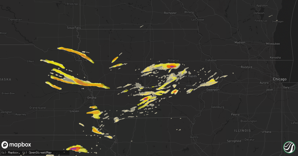
Hail Map in Iowa on April 15, 2017
Get this storm
April 15 map
$229
one time, instant access
Download today. No call, no setup
Keep the $229
Bought the map and want the full workflow? Apply the entire $229 to a subscription within 7 days. None of it is wasted.
Every map, not just this one
This buys you this map. Subscription and you get every map we run, in the markets you choose from a few cities to whole states to nationwide. Plus real-time alerts the moment a storm fires.
Contact data
Name, contact info, occupancy, even credit band for addresses in the footprint. You go from where it hit to who to call.
Become the source they trust
Unlimited branding weather history reports on demand. You already have the documented answer ready for the property owner, and you are the one who showed up with it.
Property data and RoofTrace estimates
Pull up any address you have got, its value and the exact code rules for that jurisdiction, straight from One Click Code. Then RoofTrace estimates the squares, pitch, and roof value, priced the way you price.
Storm reports in Iowa
Iowa
| Date | Description |
|---|---|
| 04/15/20176:59 PM CDT | A local report indicates 1.00 inch wind near HAMBURG |
| 04/15/20176:58 PM CDT | Also estimated winds of 40 to 50 mph. |
| 04/15/20176:51 PM CDT | Via social media. Time estimated from radar. |
| 04/15/20176:42 PM CDT | Nickel to quarter sized hail. |
| 04/15/20176:35 PM CDT | A local report indicates 1.00 inch wind near DEWITT |
| 04/15/20176:30 PM CDT | From an off duty nws employee... Time estimated on radar |
| 04/15/20176:25 PM CDT | Trained spotter reported lots of dime to quarter sized hail along highway 175 just east of the hardin-grundy county line. |
| 04/15/20176:22 PM CDT | A local report indicates 1.00 inch wind near 2 NW FARRAGUT |
| 04/15/20176:20 PM CDT | Relayed by kwqc...time estimated from radar. |
| 04/15/20176:11 PM CDT | Relayed from kwqc... Time estimated based on radar. |
| 04/15/20176:03 PM CDT | Many hailstones the size of nickels with a few the size of quarters intermixed. |
| 04/15/20176:02 PM CDT | A local report indicates 60 MPH wind near 2 SW NEW PROVIDENCE |
| 04/15/20175:46 PM CDT | A local report indicates 1.50 inch wind near 2 SW THURMAN |
| 04/15/20175:39 PM CDT | A local report indicates 1.00 inch wind near 2 SW THURMAN |
| 04/15/20175:35 PM CDT | A local report indicates 1.50 inch wind near 2 SSW FONDA |
| 04/15/20175:23 PM CDT | A local report indicates 1.00 inch wind near RIVERSIDE |
| 04/15/20175:03 PM CDT | Many hailstones the size of nickels with a few the size of quarters intermixed. |
| 04/15/20175:00 PM CDT | A local report indicates 1.00 inch wind near 4 ENE YETTER |
| 04/15/20174:57 PM CDT | A local report indicates 1.00 inch wind near 3 WSW PACIFIC JUNCTION |
| 04/15/20174:46 PM CDT | Nickels to quarter sized hail. Hail covering the ground. Winds of 50 mph. |
| 04/15/201712:08 AM CDT | A local report indicates 1.25 inch wind near 2 S PELLA |
| 04/15/201712:05 AM CDT | Time estimated by radar. |
| 04/14/201710:00 PM CDT | Pea/dime/quarter sized right now. |
| 04/14/20179:27 PM CDT | Dime to quarter sized hail at the mills civic parkway and stagecoach drive. |
| 04/14/20179:20 PM CDT | A local report indicates 1.00 inch wind near PORTSMOUTH |
| 04/14/20179:18 PM CDT | A local report indicates 1.75 inch wind near 10 N PERSIA |
| 04/14/20178:59 PM CDT | A local report indicates 1.00 inch wind near LOGAN |
| 04/14/20178:55 PM CDT | A local report indicates 1.50 inch wind near LOGAN |
| 04/14/20178:54 PM CDT | Farm damage at one residence of 1 shed destroyed... 2 other buildings metal roofing off. Tree damage and powerline damage in same location. Metal roofing from this resi |
| 04/14/20178:53 PM CDT | A local report indicates 1.00 inch wind near W BELLE PLAINE |
| 04/14/20178:52 PM CDT | A local report indicates 1.50 inch wind near MAGNOLIA |
| 04/14/20178:50 PM CDT | Ef-1 tornado began around 850 pm cdt saturday evening...4 miles northeast of anamosa. The tornado tracked around 3 miles to the east before lifting...with damage to tre |
| 04/14/20178:43 PM CDT | A local report indicates 1.50 inch wind near MONDAMIN |
| 04/14/20178:29 PM CDT | A local report indicates 1.00 inch wind near W BELLE PLAINE |
| 04/14/20178:24 PM CDT | A local report indicates 2.00 inch wind near 6 ESE HINTON |
| 04/14/20178:13 PM CDT | Report and photo from twitter...time estimated from radar. |
| 04/14/20178:10 PM CDT | Law enforcement and social media photos confirmed hen egg to baseball sized hail just south of hinton. |
| 04/14/20178:10 PM CDT | Numerous reports of large hail between westfield and southeast of hinton in past half hour. Lots of broken windows in houses and cars. Largest hail was in hinton... Wit |
| 04/14/20178:08 PM CDT | Trained spotter reported quarter sized hail at his sons property. Time radar estimated. |
| 04/14/20178:08 PM CDT | In addition... There was a public report of golf ball sized hail and a broken windshield on his vehicle. |
| 04/14/20178:00 PM CDT | Trained spotter reported nickel to quarter sized hail. Time radar estimated. |
| 04/14/20177:54 PM CDT | Public reported half dollar sized hail. Image relayed by whotv via social media. |
| 04/14/20177:54 PM CDT | Trained spotter reported reported nickel to quarter sized hail on the north side of melcher-dallas. |
| 04/14/20177:40 PM CDT | Nickel to quarter hail along interstate 80 at the mile marker 86 near menlo. |
| 04/14/20177:39 PM CDT | Hail covering the ground... Making it white. Most stones were smaller... But some up to the size of quarters. |
| 04/14/20177:38 PM CDT | Time estimated from radar. |
| 04/14/20177:36 PM CDT | Trained spotter reported up to quarter sized hail. |
| 04/14/20177:31 PM CDT | A local report indicates 1.00 inch wind near 1 NNW GILBERTVILLE |
| 04/14/20177:30 PM CDT | Report via social media. |
| 04/14/20177:26 PM CDT | In the town of milo. |
| 04/14/20177:22 PM CDT | A wide swath of ping pong hail from traer to hickory hollow park. Time estimated by radar. |
| 04/14/20177:20 PM CDT | 180th and tripoli. |
| 04/14/20177:18 PM CDT | Report of windshields broken. Time estimated from radar. |
| 04/14/20177:18 PM CDT | Trained spotter reported quarter sized hail covering her yard just south of woodburn. |
| 04/14/20177:15 PM CDT | Report via social media. Time estimated by reporter. |
| 04/14/20177:13 PM CDT | Time estimated from radar. Report via social media. |
| 04/14/20177:12 PM CDT | Truck sustained hail damage just south of the black hawk and tama county line on s avenue. Time estimated by radar. |
| 04/14/20177:10 PM CDT | Trained spotter reported golf ball size hail. Delayed report. |
| 04/14/20177:10 PM CDT | Time estimated from radar. |
| 04/14/20177:10 PM CDT | A local report indicates 1.25 inch wind near 7 E NEW VIRGINIA |
| 04/14/20177:05 PM CDT | Relayed from kcrg... Time estimated |
All States Impacted by Hail Map on April 15, 2017
Cities Impacted by Hail Map on April 15, 2017
- Randolph, NE
- Carroll, NE
- Allerton, IA
- Bucyrus, KS
- Spring Hill, KS
- Van Horne, IA
- Wayne, NE
- Hoisington, KS
- Claflin, KS
- West Point, NE
- Modale, IA
- Herman, NE
- Oakland, NE
- Craig, NE
- Tekamah, NE
- Scribner, NE
- Uehling, NE
- Blair, NE
- Hooper, NE
- Monticello, IA
- Cascade, IA
- Panama, IA
- Battle Creek, NE
- Wisner, NE
- Howells, NE
- Dodge, NE
- Portsmouth, IA
- Logan, IA
- Woodbine, IA
- Missouri Valley, IA
- Mondamin, IA
- Hoskins, NE
- Persia, IA
- Magnolia, IA
- Norfolk, NE
- Stanton, NE
- Harlan, IA
- Pilger, NE
- Beemer, NE
- Leigh, NE
- Shelby, IA
- Meadow Grove, NE
- Pierce, NE
- Madison, NE
- Clarkson, NE
- Manhattan, KS
- Sheboygan, WI
- Claremore, OK
- Brooklyn, IA
- Reasnor, IA
- Lynnville, IA
- Malcom, IA
- Sully, IA
- Grinnell, IA
- Melbourne, IA
- Salem, NE
- Verdon, NE
- Humboldt, NE
- Dawson, NE
- Falls City, NE
- Stella, NE
- Abilene, KS
- Melrose, IA
- Russell, IA
- Bedford, IA
- Protection, KS
- Coldwater, KS
- Goose Lake, IA
- De Witt, IA
- Bryant, IA
- Merrill, IA
- Hinton, IA
- Pocahontas, IA
- Alton, KS
- Wellman, IA
- Searsboro, IA
- Chelsea, IA
- Monroe, IA
- Deep River, IA
- Keswick, IA
- What Cheer, IA
- Sigourney, IA
- Gibson, IA
- South English, IA
- Rose Hill, IA
- Webster, IA
- West Des Moines, IA
- Riverside, IA
- Paradise, KS
- Waldo, KS
- Great Bend, KS
- Lucas, KS
- Kiel, WI
- Enterprise, KS
- Larned, KS
- Otis, KS
- Junction City, KS
- Sac City, IA
- Fonda, IA
- Grundy Center, IA
- Pawnee Rock, KS
- Rush Center, KS
- Albert, KS
- Burdett, KS
- Randolph, KS
- Olsburg, KS
- Blue Rapids, KS
- Rozel, KS
- Elberon, IA
- Vining, IA
- Lincoln, KS
- Lake City, IA
- Osmond, NE
- Creighton, NE
- Plainview, NE
- Menlo, IA
- Frankfort, KS
- Netawaka, KS
- Whiting, KS
- Wichita, KS
- Mayetta, KS
- Holton, KS
- Pella, IA
- Knoxville, IA
- Pratt, KS
- Wilmore, KS
- Haviland, KS
- Macksville, KS
- Palo, IA
- Shellsburg, IA
- Vinton, IA
- Dixon, IA
- Hudson, IA
- Waterloo, IA
- Buckingham, IA
- La Porte City, IA
- Lost Nation, IA
- Wheatland, IA
- Calamus, IA
- Grand Mound, IA
- Anamosa, IA
- Kingman, KS
- Rantoul, KS
- Ottawa, KS
- Wellsville, KS
- Winnetoon, NE
- Verdigre, NE
- Orchard, NE
- Utica, KS
- Gove, KS
- Quinter, KS
- Oakley, KS
- Dighton, KS
- Grinnell, KS
- Arnold, KS
- Ransom, KS
- Little River, KS
- Inman, KS
- Lyons, KS
- Sterling, KS
- Windom, KS
- Mcpherson, KS
- Coffeyville, KS
- Ellinwood, KS
- Bushton, KS
- Clearfield, IA
- Diagonal, IA
- Nevada, IA
- Prole, IA
- Greenfield, IA
- Kanopolis, KS
- Ellsworth, KS
- Brookville, KS
- Holyrood, KS
- Indianola, IA
- Westfield, IA
- Lawton, IA
- Kingsley, IA
- Pierson, IA
- Moville, IA
- Akron, IA
- Muscotah, KS
- Downing, MO
- Tingley, IA
- Mount Ayr, IA
- Minneapolis, KS
- Montezuma, IA
- Glasco, KS
- Delphos, KS
- Kalona, IA
- New Liberty, IA
- Westmoreland, KS
- Onaga, KS
- Reinbeck, IA
- Traer, IA
- Beverly, KS
- Salina, KS
- Saint Helena, NE
- Gayville, SD
- Sioux City, IA
- Correctionville, IA
- Anthon, IA
- Burbank, SD
- Mission Hill, SD
- Vermillion, SD
- Yankton, SD
- Elk Point, SD
- Chariton, IA
- Arbela, MO
- Union, NE
- Thurman, IA
- Percival, IA
- Brandon, IA
- Gladbrook, IA
- Ames, IA
- Wellsburg, IA
- Dysart, IA
- New Providence, IA
- Story City, IA
- Beaman, IA
- Liscomb, IA
- Lincoln, IA
- Mount Auburn, IA
- McCallsburg, IA
- Zearing, IA
- Cedar Falls, IA
- Union, IA
- Gilbert, IA
- Jesup, IA
- Eldora, IA
- Garden City, IA
- Radcliffe, IA
- Roland, IA
- Hubbard, IA
- Morrison, IA
- Conrad, IA
- Reading, KS
- Tilden, NE
- Ellsworth, WI
- Beldenville, WI
- Plattsmouth, NE
- Pacific Junction, IA
- Murray, NE
- Osage City, KS
- Mclean, NE
- Winside, NE
- Wausa, NE
- Adair, IA
- Exira, IA
- Guthrie Center, IA
- Milo, IA
- Humphrey, NE
- Newman Grove, NE
- Platte Center, NE
- Lindsay, NE
- Humeston, IA
- Corydon, IA
- Sylvan Grove, KS
- Sheridan Lake, CO
- Hopkins, MO
- Clearmont, MO
- New Cambria, KS
- Barnes, KS
- Clive, IA
- Windsor Heights, IA
- Burchard, NE
- Geneseo, KS
- St John, KS
- Belpre, KS
- Cameron, MO
- Bussey, IA
- Adams, NE
- Tecumseh, NE
- Sterling, NE
- Crab Orchard, NE
- Albion, NE
- Beloit, KS
- Stuart, IA
- Casey, IA
- Otoe, NE
- Nehawka, NE
- Hamburg, IA
- Nebraska City, NE
- Riverton, IA
- Sidney, IA
- Melcher Dallas, IA
- Garfield, KS
- Offerle, KS
- Lewis, KS
- Kinsley, KS
- Tracy, IA
- Oskaloosa, IA
- Brunswick, NE
- Soldier, KS
- Baileyville, KS
- Barnes City, IA
- New Sharon, IA
- Saint Charles, IA
- Leighton, IA
- Pleasantville, IA
- Hartford, IA
- Harvey, IA
- Swan, IA
- Martensdale, IA
- Bevington, IA
- Ackworth, IA
- Otley, IA
- Carlisle, IA
- Adel, IA
- Leon, IA
- Douglass, KS
- Augusta, KS
- White Cloud, KS
- Forest City, MO
- Oregon, MO
- Walcott, IA
- Donahue, IA
- Solomon, KS
- Columbus, NE
- Newton, IA
- Kellogg, IA
- Anita, IA
- Wiota, IA
- Marengo, IA
- Fort Stockton, TX
- Rock Port, MO
- Belle Plaine, IA
- Little Sioux, IA
- Lenox, IA
- Turon, KS
- Iuka, KS
- Durant, IA
- Long Grove, IA
- Stockton, IA
- Bennett, IA
- Wilton, IA
- Camanche, IA
- Tipton, IA
- McCausland, IA
- Eldridge, IA
- Lucas, IA
- Liberty Center, IA
- Woodburn, IA
- Lacona, IA
- New Virginia, IA
- Wright, KS
- Fairfax, MO
- Pender, NE
- Wakefield, NE
- Scott City, KS
- Alden, IA
- Gilman, IA
- Garden Plain, KS
- Cheney, KS
- Shenandoah, IA
- Overbrook, KS
- Coin, IA
- Westboro, MO
- Northboro, IA
- Blanchard, IA
- Tarkio, MO
- Glenwood, IA
- Waterville, KS
- Pryor, OK
- Le Mars, IA
- Lanark, IL
- Polo, IL
- Forreston, IL
- Pilot Mound, IA
- Garden Grove, IA
- Avoca, IA
- Pisgah, IA
- Seymour, IA
- Promise City, IA
- Plano, IA
- Victor, IA
- Ladora, IA
- Guernsey, IA
- Columbia, IA
- Edna, KS
- Elk City, KS
- Sedan, KS
- Luzerne, IA
- Hartwick, IA
- Keystone, IA
- Killduff, IA
- Tama, IA
- Toledo, IA
- Clutier, IA
- Tabor, IA
- Clarinda, IA
- Pickering, MO
- Shubert, NE
- Rulo, NE
- Auburn, IA
- Lake View, IA
- Rockwell City, IA
- Atalissa, IA
- Delmar, IA
- Moscow, IA
- West Liberty, IA
- Charlotte, IA
- Marshalltown, IA
- Garrison, IA
- Boone, IA
- Saint Anthony, IA
- Albion, IA
- Monmouth, IA
- Wyoming, IA
- Silver Lake, KS
- Delia, KS
- Topeka, KS
- Meriden, KS
- Hoyt, KS
- Derby, KS
- River Falls, WI
- Lovilia, IA
- Panora, IA
- Linden, IA
- Hanston, KS
- Spearville, KS
- Lowden, IA
- Clarence, IA
- Knox City, MO
- Auburn, NE
- Craig, MO
- Edina, MO
- Clay Center, KS
- Green, KS
- Ellston, IA
- Highland, KS
- Robinson, KS
- Thayer, IA
- Wilson, KS
- Salina, OK
- Spavinaw, OK
- Winfield, KS
- Maryville, MO
- Burlington Junction, MO
- Sheridan, MO
- Thomson, IL
- Norwalk, IA
- Cumming, IA
- Truro, IA
- Derby, IA
- Winterset, IA
- Patterson, IA
- Osceola, IA
- Weldon, IA
- Van Wert, IA
- Miltonvale, KS
- New Holstein, WI
- Van Meter, IA
- North English, IA
- Delta, IA
- Cunningham, KS
- Dexter, IA
- Mullinville, KS
- Horton, KS
- Powhattan, KS
- Dwight, KS
- Council Grove, KS
- Alta Vista, KS
- Lineville, IA
- Morganville, KS
- Rowley, IA
- Lone Tree, IA
- Wells, MN
- Avoca, NE
- Luray, KS
- Saint George, KS
- Wamego, KS
- Amazonia, MO
- Savannah, MO
- Moundridge, KS
- Fremont, IA
- Cedar, IA
- Wellington, KS
- Conway Springs, KS
- Clearwater, KS
- Hamilton, IA
- Blairstown, IA
- Atkins, IA
- Center Point, IA
- Cedar Rapids, IA
- Walker, IA
- Watkins, IA
- Newhall, IA
- Toddville, IA
- Montour, IA
- Des Moines, IA
- Grimes, IA
- Johnston, IA
- Dallas Center, IA
- Redfield, IA
- Booneville, IA
- Waukee, IA
- Minburn, IA
- Earlham, IA
- Urbandale, IA
- Norway, IA
- West Branch, IA
- Monroe, NE
- Somers, IA
- Bern, KS
- Keota, IA
- Wall Lake, IA
- Central City, IA
- Longford, KS
- Arlington, NE
- Kiester, MN
- Bricelyn, MN
- Walnut, IA
- Dunlap, IA
- Natoma, KS
- Aurora, KS
- Gypsum, KS
- Valley Center, KS
- Murray, IA
- Rossville, KS
- Gravity, IA
- New Market, IA
- Prescott, WI
- Olathe, KS
- Shannon City, IA
- Grand River, IA
- Eads, CO
- Callender, IA
- Elk Falls, KS
- Ferguson, IA
- Saint Marys, KS
- Bunker Hill, KS
- Russell, KS
- Iraan, TX
- Mount Carroll, IL
- Chadwick, IL
- Fulton, IL
- Clinton, IA
- Smyrna, DE
- Dover, DE
- Breda, IA
- Westside, IA
- Decatur, NE
- Dorrance, KS
- Goddard, KS
- Viola, KS
- Olin, IA
- Saint Edward, NE
- Marion, IA
- Alburnett, IA
- Robins, IA
- Maquoketa, IA
- Elmo, MO
- Madrid, IA
- Colo, IA
- Steamboat Rock, IA
- Oxford Junction, IA
- Evansdale, IA
- Iowa City, IA
- State Center, IA
- Williamsburg, IA
- Rose Hill, KS
- Moline, KS
- Delaware, OK
- Spragueville, IA
- Preston, IA
- Pleasant Hill, IA
- Murdock, KS
- Lamoni, IA
- Nemaha, NE
- Laurel, IA
- Haverhill, IA
- Bancroft, NE
- Sabetha, KS
- White City, KS
- Woodward, IA
- Osborne, KS
- Stanwood, IA
- Altoona, IA
- Runnells, IA
- Independence, KS
- Kellerton, IA
- Redding, IA
- Paola, KS
- Osawatomie, KS
- Randolph, IA
- Farragut, IA
- Morrill, KS
- Hiawatha, KS
- Crofton, NE
- Palmer, KS
- Elkhart Lake, WI
- Clemons, IA
- Gettysburg, SD
- Isabel, KS
- Washington, IA
- Ainsworth, IA
- Albia, IA
- Onslow, IA
- Havensville, KS
- Nashville, KS
- Prairie City, IA
- Colfax, IA
- Oxford, KS
- Elk Horn, IA
- Dunbar, NE
- Hastings, MN
- Hager City, WI
- Greenleaf, KS
- Brownell, KS


