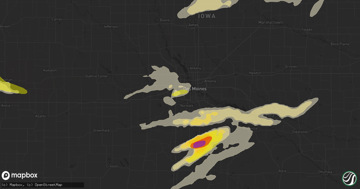
Hail Map in West Des Moines, IA on April 15, 2017
Get this storm
April 15 map
$229
one time, instant access
Download today. No call, no setup
Keep the $229
Bought the map and want the full workflow? Apply the entire $229 to a subscription within 7 days. None of it is wasted.
Every map, not just this one
This buys you this map. Subscription and you get every map we run, in the markets you choose from a few cities to whole states to nationwide. Plus real-time alerts the moment a storm fires.
Contact data
Name, contact info, occupancy, even credit band for addresses in the footprint. You go from where it hit to who to call.
Become the source they trust
Unlimited branding weather history reports on demand. You already have the documented answer ready for the property owner, and you are the one who showed up with it.
Property data and RoofTrace estimates
Pull up any address you have got, its value and the exact code rules for that jurisdiction, straight from One Click Code. Then RoofTrace estimates the squares, pitch, and roof value, priced the way you price.
Storm reports in West Des Moines, IA
West Des Moines, IA
| Date | Description |
|---|---|
| 04/14/20179:27 PM CDT | Dime to quarter sized hail at the mills civic parkway and stagecoach drive. |
All States Impacted by Hail Map on April 15, 2017
All Cities Impacted by Hail Map on April 15, 2017
- Randolph, NE
- Carroll, NE
- Allerton, IA
- Bucyrus, KS
- Spring Hill, KS
- Van Horne, IA
- Wayne, NE
- Hoisington, KS
- Claflin, KS
- West Point, NE
- Modale, IA
- Herman, NE
- Oakland, NE
- Craig, NE
- Tekamah, NE
- Scribner, NE
- Uehling, NE
- Blair, NE
- Hooper, NE
- Monticello, IA
- Cascade, IA
- Panama, IA
- Battle Creek, NE
- Wisner, NE
- Howells, NE
- Dodge, NE
- Portsmouth, IA
- Logan, IA
- Woodbine, IA
- Missouri Valley, IA
- Mondamin, IA
- Hoskins, NE
- Persia, IA
- Magnolia, IA
- Norfolk, NE
- Stanton, NE
- Harlan, IA
- Pilger, NE
- Beemer, NE
- Leigh, NE
- Shelby, IA
- Meadow Grove, NE
- Pierce, NE
- Madison, NE
- Clarkson, NE
- Manhattan, KS
- Sheboygan, WI
- Claremore, OK
- Brooklyn, IA
- Reasnor, IA
- Lynnville, IA
- Malcom, IA
- Sully, IA
- Grinnell, IA
- Melbourne, IA
- Salem, NE
- Verdon, NE
- Humboldt, NE
- Dawson, NE
- Falls City, NE
- Stella, NE
- Abilene, KS
- Melrose, IA
- Russell, IA
- Bedford, IA
- Protection, KS
- Coldwater, KS
- Goose Lake, IA
- De Witt, IA
- Bryant, IA
- Merrill, IA
- Hinton, IA
- Pocahontas, IA
- Alton, KS
- Wellman, IA
- Searsboro, IA
- Chelsea, IA
- Monroe, IA
- Deep River, IA
- Keswick, IA
- What Cheer, IA
- Sigourney, IA
- Gibson, IA
- South English, IA
- Rose Hill, IA
- Webster, IA
- West Des Moines, IA
- Riverside, IA
- Paradise, KS
- Waldo, KS
- Great Bend, KS
- Lucas, KS
- Kiel, WI
- Enterprise, KS
- Larned, KS
- Otis, KS
- Junction City, KS
- Sac City, IA
- Fonda, IA
- Grundy Center, IA
- Pawnee Rock, KS
- Rush Center, KS
- Albert, KS
- Burdett, KS
- Randolph, KS
- Olsburg, KS
- Blue Rapids, KS
- Rozel, KS
- Elberon, IA
- Vining, IA
- Lincoln, KS
- Lake City, IA
- Osmond, NE
- Creighton, NE
- Plainview, NE
- Menlo, IA
- Frankfort, KS
- Netawaka, KS
- Whiting, KS
- Wichita, KS
- Mayetta, KS
- Holton, KS
- Pella, IA
- Knoxville, IA
- Pratt, KS
- Wilmore, KS
- Haviland, KS
- Macksville, KS
- Palo, IA
- Shellsburg, IA
- Vinton, IA
- Dixon, IA
- Hudson, IA
- Waterloo, IA
- Buckingham, IA
- La Porte City, IA
- Lost Nation, IA
- Wheatland, IA
- Calamus, IA
- Grand Mound, IA
- Anamosa, IA
- Kingman, KS
- Rantoul, KS
- Ottawa, KS
- Wellsville, KS
- Winnetoon, NE
- Verdigre, NE
- Orchard, NE
- Utica, KS
- Gove, KS
- Quinter, KS
- Oakley, KS
- Dighton, KS
- Grinnell, KS
- Arnold, KS
- Ransom, KS
- Little River, KS
- Inman, KS
- Lyons, KS
- Sterling, KS
- Windom, KS
- Mcpherson, KS
- Coffeyville, KS
- Ellinwood, KS
- Bushton, KS
- Clearfield, IA
- Diagonal, IA
- Nevada, IA
- Prole, IA
- Greenfield, IA
- Kanopolis, KS
- Ellsworth, KS
- Brookville, KS
- Holyrood, KS
- Indianola, IA
- Westfield, IA
- Lawton, IA
- Kingsley, IA
- Pierson, IA
- Moville, IA
- Akron, IA
- Muscotah, KS
- Downing, MO
- Tingley, IA
- Mount Ayr, IA
- Minneapolis, KS
- Montezuma, IA
- Glasco, KS
- Delphos, KS
- Kalona, IA
- New Liberty, IA
- Westmoreland, KS
- Onaga, KS
- Reinbeck, IA
- Traer, IA
- Beverly, KS
- Salina, KS
- Saint Helena, NE
- Gayville, SD
- Sioux City, IA
- Correctionville, IA
- Anthon, IA
- Burbank, SD
- Mission Hill, SD
- Vermillion, SD
- Yankton, SD
- Elk Point, SD
- Chariton, IA
- Arbela, MO
- Union, NE
- Thurman, IA
- Percival, IA
- Brandon, IA
- Gladbrook, IA
- Ames, IA
- Wellsburg, IA
- Dysart, IA
- New Providence, IA
- Story City, IA
- Beaman, IA
- Liscomb, IA
- Lincoln, IA
- Mount Auburn, IA
- McCallsburg, IA
- Zearing, IA
- Cedar Falls, IA
- Union, IA
- Gilbert, IA
- Jesup, IA
- Eldora, IA
- Garden City, IA
- Radcliffe, IA
- Roland, IA
- Hubbard, IA
- Morrison, IA
- Conrad, IA
- Reading, KS
- Tilden, NE
- Ellsworth, WI
- Beldenville, WI
- Plattsmouth, NE
- Pacific Junction, IA
- Murray, NE
- Osage City, KS
- Mclean, NE
- Winside, NE
- Wausa, NE
- Adair, IA
- Exira, IA
- Guthrie Center, IA
- Milo, IA
- Humphrey, NE
- Newman Grove, NE
- Platte Center, NE
- Lindsay, NE
- Humeston, IA
- Corydon, IA
- Sylvan Grove, KS
- Sheridan Lake, CO
- Hopkins, MO
- Clearmont, MO
- New Cambria, KS
- Barnes, KS
- Clive, IA
- Windsor Heights, IA
- Burchard, NE
- Geneseo, KS
- St John, KS
- Belpre, KS
- Cameron, MO
- Bussey, IA
- Adams, NE
- Tecumseh, NE
- Sterling, NE
- Crab Orchard, NE
- Albion, NE
- Beloit, KS
- Stuart, IA
- Casey, IA
- Otoe, NE
- Nehawka, NE
- Hamburg, IA
- Nebraska City, NE
- Riverton, IA
- Sidney, IA
- Melcher Dallas, IA
- Garfield, KS
- Offerle, KS
- Lewis, KS
- Kinsley, KS
- Tracy, IA
- Oskaloosa, IA
- Brunswick, NE
- Soldier, KS
- Baileyville, KS
- Barnes City, IA
- New Sharon, IA
- Saint Charles, IA
- Leighton, IA
- Pleasantville, IA
- Hartford, IA
- Harvey, IA
- Swan, IA
- Martensdale, IA
- Bevington, IA
- Ackworth, IA
- Otley, IA
- Carlisle, IA
- Adel, IA
- Leon, IA
- Douglass, KS
- Augusta, KS
- White Cloud, KS
- Forest City, MO
- Oregon, MO
- Walcott, IA
- Donahue, IA
- Solomon, KS
- Columbus, NE
- Newton, IA
- Kellogg, IA
- Anita, IA
- Wiota, IA
- Marengo, IA
- Fort Stockton, TX
- Rock Port, MO
- Belle Plaine, IA
- Little Sioux, IA
- Lenox, IA
- Turon, KS
- Iuka, KS
- Durant, IA
- Long Grove, IA
- Stockton, IA
- Bennett, IA
- Wilton, IA
- Camanche, IA
- Tipton, IA
- McCausland, IA
- Eldridge, IA
- Lucas, IA
- Liberty Center, IA
- Woodburn, IA
- Lacona, IA
- New Virginia, IA
- Wright, KS
- Fairfax, MO
- Pender, NE
- Wakefield, NE
- Scott City, KS
- Alden, IA
- Gilman, IA
- Garden Plain, KS
- Cheney, KS
- Shenandoah, IA
- Overbrook, KS
- Coin, IA
- Westboro, MO
- Northboro, IA
- Blanchard, IA
- Tarkio, MO
- Glenwood, IA
- Waterville, KS
- Pryor, OK
- Le Mars, IA
- Lanark, IL
- Polo, IL
- Forreston, IL
- Pilot Mound, IA
- Garden Grove, IA
- Avoca, IA
- Pisgah, IA
- Seymour, IA
- Promise City, IA
- Plano, IA
- Victor, IA
- Ladora, IA
- Guernsey, IA
- Columbia, IA
- Edna, KS
- Elk City, KS
- Sedan, KS
- Luzerne, IA
- Hartwick, IA
- Keystone, IA
- Killduff, IA
- Tama, IA
- Toledo, IA
- Clutier, IA
- Tabor, IA
- Clarinda, IA
- Pickering, MO
- Shubert, NE
- Rulo, NE
- Auburn, IA
- Lake View, IA
- Rockwell City, IA
- Atalissa, IA
- Delmar, IA
- Moscow, IA
- West Liberty, IA
- Charlotte, IA
- Marshalltown, IA
- Garrison, IA
- Boone, IA
- Saint Anthony, IA
- Albion, IA
- Monmouth, IA
- Wyoming, IA
- Silver Lake, KS
- Delia, KS
- Topeka, KS
- Meriden, KS
- Hoyt, KS
- Derby, KS
- River Falls, WI
- Lovilia, IA
- Panora, IA
- Linden, IA
- Hanston, KS
- Spearville, KS
- Lowden, IA
- Clarence, IA
- Knox City, MO
- Auburn, NE
- Craig, MO
- Edina, MO
- Clay Center, KS
- Green, KS
- Ellston, IA
- Highland, KS
- Robinson, KS
- Thayer, IA
- Wilson, KS
- Salina, OK
- Spavinaw, OK
- Winfield, KS
- Maryville, MO
- Burlington Junction, MO
- Sheridan, MO
- Thomson, IL
- Norwalk, IA
- Cumming, IA
- Truro, IA
- Derby, IA
- Winterset, IA
- Patterson, IA
- Osceola, IA
- Weldon, IA
- Van Wert, IA
- Miltonvale, KS
- New Holstein, WI
- Van Meter, IA
- North English, IA
- Delta, IA
- Cunningham, KS
- Dexter, IA
- Mullinville, KS
- Horton, KS
- Powhattan, KS
- Dwight, KS
- Council Grove, KS
- Alta Vista, KS
- Lineville, IA
- Morganville, KS
- Rowley, IA
- Lone Tree, IA
- Wells, MN
- Avoca, NE
- Luray, KS
- Saint George, KS
- Wamego, KS
- Amazonia, MO
- Savannah, MO
- Moundridge, KS
- Fremont, IA
- Cedar, IA
- Wellington, KS
- Conway Springs, KS
- Clearwater, KS
- Hamilton, IA
- Blairstown, IA
- Atkins, IA
- Center Point, IA
- Cedar Rapids, IA
- Walker, IA
- Watkins, IA
- Newhall, IA
- Toddville, IA
- Montour, IA
- Des Moines, IA
- Grimes, IA
- Johnston, IA
- Dallas Center, IA
- Redfield, IA
- Booneville, IA
- Waukee, IA
- Minburn, IA
- Earlham, IA
- Urbandale, IA
- Norway, IA
- West Branch, IA
- Monroe, NE
- Somers, IA
- Bern, KS
- Keota, IA
- Wall Lake, IA
- Central City, IA
- Longford, KS
- Arlington, NE
- Kiester, MN
- Bricelyn, MN
- Walnut, IA
- Dunlap, IA
- Natoma, KS
- Aurora, KS
- Gypsum, KS
- Valley Center, KS
- Murray, IA
- Rossville, KS
- Gravity, IA
- New Market, IA
- Prescott, WI
- Olathe, KS
- Shannon City, IA
- Grand River, IA
- Eads, CO
- Callender, IA
- Elk Falls, KS
- Ferguson, IA
- Saint Marys, KS
- Bunker Hill, KS
- Russell, KS
- Iraan, TX
- Mount Carroll, IL
- Chadwick, IL
- Fulton, IL
- Clinton, IA
- Smyrna, DE
- Dover, DE
- Breda, IA
- Westside, IA
- Decatur, NE
- Dorrance, KS
- Goddard, KS
- Viola, KS
- Olin, IA
- Saint Edward, NE
- Marion, IA
- Alburnett, IA
- Robins, IA
- Maquoketa, IA
- Elmo, MO
- Madrid, IA
- Colo, IA
- Steamboat Rock, IA
- Oxford Junction, IA
- Evansdale, IA
- Iowa City, IA
- State Center, IA
- Williamsburg, IA
- Rose Hill, KS
- Moline, KS
- Delaware, OK
- Spragueville, IA
- Preston, IA
- Pleasant Hill, IA
- Murdock, KS
- Lamoni, IA
- Nemaha, NE
- Laurel, IA
- Haverhill, IA
- Bancroft, NE
- Sabetha, KS
- White City, KS
- Woodward, IA
- Osborne, KS
- Stanwood, IA
- Altoona, IA
- Runnells, IA
- Independence, KS
- Kellerton, IA
- Redding, IA
- Paola, KS
- Osawatomie, KS
- Randolph, IA
- Farragut, IA
- Morrill, KS
- Hiawatha, KS
- Crofton, NE
- Palmer, KS
- Elkhart Lake, WI
- Clemons, IA
- Gettysburg, SD
- Isabel, KS
- Washington, IA
- Ainsworth, IA
- Albia, IA
- Onslow, IA
- Havensville, KS
- Nashville, KS
- Prairie City, IA
- Colfax, IA
- Oxford, KS
- Elk Horn, IA
- Dunbar, NE
- Hastings, MN
- Hager City, WI
- Greenleaf, KS
- Brownell, KS


