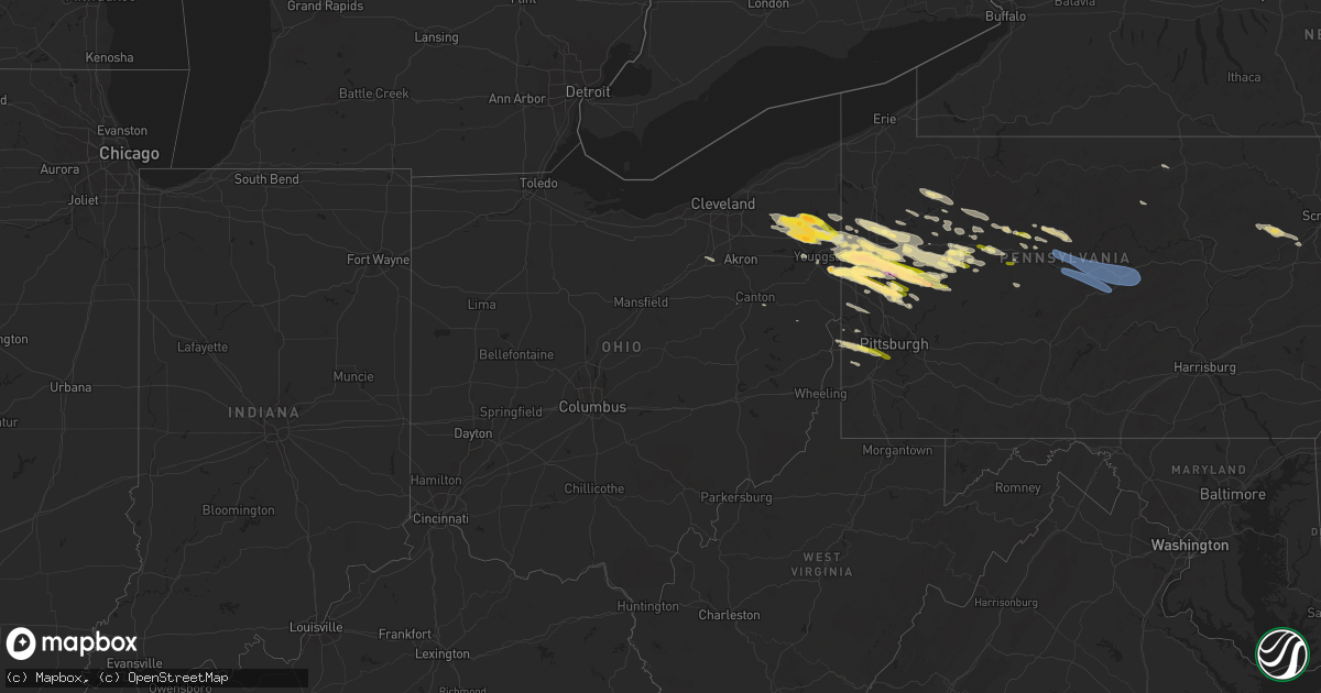
Hail Map in Ohio on April 14, 2024
Get this storm
April 14 map
$229
one time, instant access
Download today. No call, no setup
Keep the $229
Bought the map and want the full workflow? Apply the entire $229 to a subscription within 7 days. None of it is wasted.
Every map, not just this one
This buys you this map. Subscription and you get every map we run, in the markets you choose from a few cities to whole states to nationwide. Plus real-time alerts the moment a storm fires.
Contact data
Name, contact info, occupancy, even credit band for addresses in the footprint. You go from where it hit to who to call.
Become the source they trust
Unlimited branding weather history reports on demand. You already have the documented answer ready for the property owner, and you are the one who showed up with it.
Property data and RoofTrace estimates
Pull up any address you have got, its value and the exact code rules for that jurisdiction, straight from One Click Code. Then RoofTrace estimates the squares, pitch, and roof value, priced the way you price.
Storm reports in Ohio
Ohio
| Date | Description |
|---|---|
| 04/14/20246:21 PM CDT | Social media report of hail up to 1.5 inches in poland. |
| 04/14/20244:54 PM CDT | A local report indicates 1.00 inch wind near Hubbard |
| 04/14/20244:35 PM CDT | Asos station kyng youngstown measured a 59 kt thunderstorm wind gust. |
| 04/14/20244:34 PM CDT | Report from mping: golf ball |
| 04/14/20244:34 PM CDT | Social media photo shows hail up to half dollar size in howland township. |
| 04/14/20244:33 PM CDT | Trained spotter reported one inch hail west of warren. |
| 04/14/20244:33 PM CDT | Hail for nearly 5 minutes is covering the ground. |
| 04/14/20244:28 PM CDT | Trained spotter reported quarter sized hail near sr 5 and sr 46 near cortland. |
| 04/14/20244:26 PM CDT | 8 minutes of hail with some up to quarter-sized in fowler twp. |
| 04/14/20244:15 PM CDT | Social media report of hail up to ping pong ball in bristolville. |
| 04/14/20244:14 PM CDT | Nws employee reports hail of dime to quarter size just east of parkman in se geauga county. |
| 04/13/20247:00 PM CDT | Mostly dime to nickel sized... Some as large as quarter sized. |
All States Impacted by Hail Map on April 14, 2024
Cities Impacted by Hail Map on April 14, 2024
- Titusville, PA
- Greenville, PA
- Bristolville, OH
- West Farmington, OH
- Pleasantville, PA
- Fredonia, PA
- Kinsman, OH
- Hiram, OH
- Burton, OH
- Chagrin Falls, OH
- Utica, PA
- Franklin, PA
- North Bloomfield, OH
- Middlefield, OH
- Cortland, OH
- Clarks Mills, PA
- Stoneboro, PA
- Southington, OH
- Garrettsville, OH
- Warren, OH
- Mercer, PA
- Polk, PA
- Sharpsville, PA
- Burghill, OH
- Transfer, PA
- Jackson Center, PA
- Tionesta, PA
- Fowler, OH
- Vienna, OH
- Sandy Lake, PA
- Mantua, OH
- Windham, OH
- Farmdale, OH
- Reno, PA
- Oil City, PA
- Wellsboro, PA
- Brookfield, OH
- Leavittsburg, OH
- Niles, OH
- Grove City, PA
- Kennerdell, PA
- Masury, OH
- Marienville, PA
- Vowinckel, PA
- Sigel, PA
- Marble, PA
- Seneca, PA
- Lucinda, PA
- Cranberry, PA
- Shippenville, PA
- Venus, PA
- Newton Falls, OH
- Hermitage, PA
- Sharon, PA
- Hubbard, OH
- Farrell, PA
- Brockway, PA
- Clarion, PA
- Weedville, PA
- Ridgway, PA
- West Middlesex, PA
- Pulaski, PA
- New Wilmington, PA
- Emlenton, PA
- Harrisville, PA
- Parker, PA
- Boyers, PA
- Clintonville, PA
- Volant, PA
- Wheatland, PA
- Cammal, PA
- Kersey, PA
- Benezett, PA
- Cedar Run, PA
- Penfield, PA
- Rimersburg, PA
- New Castle, PA
- Slippery Rock, PA
- Girard, OH
- Lowellville, OH
- North Jackson, OH
- Brockport, PA
- Edinburg, PA
- Clearfield, PA
- Frenchville, PA
- Morrisdale, PA
- Drifting, PA
- Grassflat, PA
- Portersville, PA
- West Sunbury, PA
- Butler, PA
- Benton, PA
- Sweet Valley, PA
- Bruin, PA
- Hilliards, PA
- Petrolia, PA
- Eau Claire, PA
- Reynoldsville, PA
- Karns City, PA
- Chicora, PA
- Fenelton, PA
- Worthington, PA
- East Brady, PA
- Cowansville, PA
- Kittanning, PA
- Adrian, PA
- Hunlock Creek, PA
- Joseph, OR
- Enterprise, OR
- Shickshinny, PA
- Glen Campbell, PA
- Mahaffey, PA
- Punxsutawney, PA
- Shavertown, PA
- Snow Shoe, PA
- Howard, PA
- Moshannon, PA
- Clarence, PA
- Bellefonte, PA
- Karthaus, PA
- Julian, PA
- Milesburg, PA
- Fleming, PA
- Philipsburg, PA
- West Decatur, PA
- Woodland, PA
- Bigler, PA
- Wallaceton, PA
- Winburne, PA
- Lanse, PA
- Kylertown, PA
- Allport, PA
- Munson, PA
- Hawk Run, PA
- Port Matilda, PA
- Curwensville, PA
- Knox, PA
- La Jose, PA
- Wilkes Barre, PA
- Nanticoke, PA
- Plymouth, PA
- Centre Hall, PA
- Spring Mills, PA
- Madisonburg, PA
- Rebersburg, PA
- State College, PA
- Youngstown, OH
- Dayton, PA
- Templeton, PA
- New Middletown, OH
- Bessemer, PA
- Fryburg, PA
- Enon Valley, PA
- Wampum, PA
- Ellwood City, PA
- Fairmount City, PA
- Summerville, PA
- New Bethlehem, PA
- Sligo, PA
- Brookville, PA
- Clarington, PA
- Petersburg, OH
- North Lima, OH
- New Galilee, PA
- Canfield, OH
- Strattanville, PA
- Corsica, PA
- Mayport, PA
- West Pittsburg, PA
- Du Bois, PA
- Hillsville, PA
- Harmony, PA
- Prospect, PA
- Evans City, PA
- White Bird, ID
- Renfrew, PA
- Fombell, PA
- Cabot, PA
- Coolspring, PA
- Connoquenessing, PA
- Hawthorn, PA
- Worthville, PA
- Lewistown, MT
- Lyndora, PA
- Darlington, PA
- Beaver Falls, PA
- Industry, PA
- Ringgold, PA
- Timblin, PA
- Sarver, PA
- Saxonburg, PA
- Beaver, PA
- Grass Range, MT
- Monaca, PA
- Rochester, PA
- New Brighton, PA
- Medina, OH
- Seville, OH
- Valencia, PA
- Freedom, PA
- Wadsworth, OH
- Kooskia, ID
- Canton, OH
- East Canton, OH
- Navarre, OH
- Mechanicstown, OH
- Waynesburg, OH
- Weirton, WV
- Burgettstown, PA
- Bulger, PA
- Georgetown, PA
- Clinton, PA
- McDonald, PA
- Avella, PA
- Aliquippa, PA
- Sturgeon, PA
- Bridgeville, PA
- Cuddy, PA
- Morgan, PA
- Oakdale, PA
- Hickory, PA
- Pittsburgh, PA
- Sykesville, PA
- Presto, PA
- Bethel Park, PA


