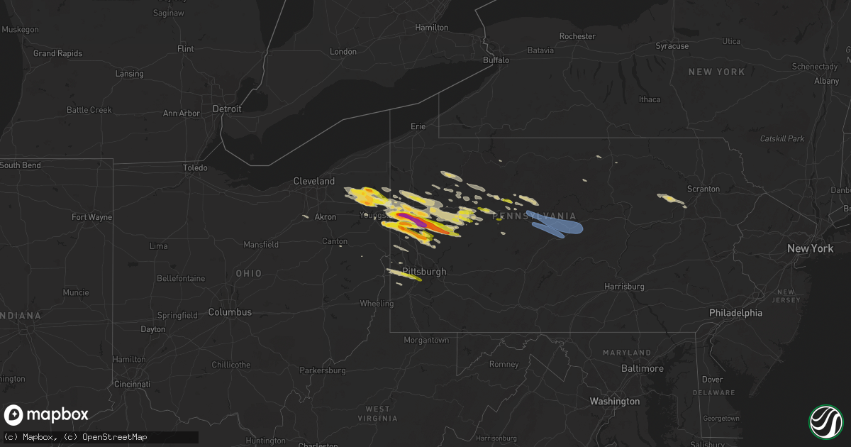
Hail Map on April 14, 2024
Get this storm
April 14 map
$229
one time, instant access
Download today. No call, no setup
Keep the $229
Bought the map and want the full workflow? Apply the entire $229 to a subscription within 7 days. None of it is wasted.
Every map, not just this one
This buys you this map. Subscription and you get every map we run, in the markets you choose from a few cities to whole states to nationwide. Plus real-time alerts the moment a storm fires.
Contact data
Name, contact info, occupancy, even credit band for addresses in the footprint. You go from where it hit to who to call.
Become the source they trust
Unlimited branding weather history reports on demand. You already have the documented answer ready for the property owner, and you are the one who showed up with it.
Property data and RoofTrace estimates
Pull up any address you have got, its value and the exact code rules for that jurisdiction, straight from One Click Code. Then RoofTrace estimates the squares, pitch, and roof value, priced the way you price.
States Impacted by Hail Map on April 14, 2024
Storm reports
Ohio
| Date | Description |
|---|---|
| 04/14/20246:21 PM CDT | Social media report of hail up to 1.5 inches in poland. |
| 04/14/20244:54 PM CDT | A local report indicates 1.00 inch wind near Hubbard |
| 04/14/20244:35 PM CDT | Asos station kyng youngstown measured a 59 kt thunderstorm wind gust. |
| 04/14/20244:34 PM CDT | Social media photo shows hail up to half dollar size in howland township. |
| 04/14/20244:34 PM CDT | Report from mping: golf ball |
| 04/14/20244:33 PM CDT | Trained spotter reported one inch hail west of warren. |
| 04/14/20244:33 PM CDT | Hail for nearly 5 minutes is covering the ground. |
| 04/14/20244:28 PM CDT | Trained spotter reported quarter sized hail near sr 5 and sr 46 near cortland. |
| 04/14/20244:26 PM CDT | 8 minutes of hail with some up to quarter-sized in fowler twp. |
| 04/14/20244:15 PM CDT | Social media report of hail up to ping pong ball in bristolville. |
| 04/14/20244:14 PM CDT | Nws employee reports hail of dime to quarter size just east of parkman in se geauga county. |
| 04/13/20247:00 PM CDT | Mostly dime to nickel sized... Some as large as quarter sized. |
Pennsylvania
| Date | Description |
|---|---|
| 04/14/20246:57 PM CDT | A local report indicates 1.00 inch wind near Brookville |
| 04/14/20246:54 PM CDT | A local report indicates 1.25 inch wind near 6 S Clarion |
| 04/14/20246:53 PM CDT | (pb |
| 04/14/20246:53 PM CDT | A local report indicates 1.50 inch wind near New Castle |
| 04/14/20246:53 PM CDT | A local report indicates 1.00 inch wind near 5 N New Castle |
| 04/14/20246:52 PM CDT | A local report indicates 1.25 inch wind near New Castle |
| 04/14/20246:52 PM CDT | A local report indicates 1.00 inch wind near New Castle |
| 04/14/20246:49 PM CDT | Reports of trees down at the intersection of hill road and west broadway in jim thorpe. Time estimated from radar. |
| 04/14/20246:48 PM CDT | Multiple trees down across various streets and roads in the lewisburg-milton areas. Id 152109. |
| 04/14/20246:42 PM CDT | A local report indicates 1.00 inch wind near 5 S New Wilmington |
| 04/14/20246:42 PM CDT | A local report indicates 1.00 inch wind near East Brady |
| 04/14/20246:41 PM CDT | A local report indicates 1.25 inch wind near New Wilmington |
| 04/14/20246:41 PM CDT | A local report indicates 1.00 inch wind near 3 N New Castle |
| 04/14/20246:40 PM CDT | A local report indicates 1.25 inch wind near 6 S Clarion |
| 04/14/20246:37 PM CDT | A local report indicates 1.00 inch wind near Karns City |
| 04/14/20246:35 PM CDT | Trees down across the road on fox hill road near the turn on the corner to the airport. |
| 04/14/20246:35 PM CDT | Report of trees down on state route 940. Time estimated from radar. |
| 04/14/20246:35 PM CDT | A local report indicates 1.50 inch wind near 3 SSE South New Castle |
| 04/14/20246:35 PM CDT | So far the fifth storm of the evening. |
| 04/14/20246:33 PM CDT | Multiple reports of trees and wires down in butler township. |
| 04/14/20246:33 PM CDT | Report from clinton county em - roof blown off of building. |
| 04/14/20246:26 PM CDT | Multiple reports of trees and wires down in sugarloaf area. |
| 04/14/20246:22 PM CDT | Wind gust reported via metar. |
| 04/14/20246:19 PM CDT | Multiple reports of trees and wires down. |
| 04/14/20246:14 PM CDT | A local report indicates 1.00 inch wind near Rimersburg |
| 04/14/20246:13 PM CDT | A local report indicates 1.00 inch wind near SE Slippery Rock |
| 04/14/20246:01 PM CDT | 900 block of walnut str. Tree down on electrical wires. |
| 04/14/20245:58 PM CDT | Pole and trees down - wires down. |
| 04/14/20245:55 PM CDT | Trees reported on roadway. |
| 04/14/20245:54 PM CDT | A local report indicates 1.00 inch wind near 3 N Worthington |
| 04/14/20245:53 PM CDT | Report from mping: quarter |
| 04/14/20245:50 PM CDT | Tree reported on roadway |
| 04/14/20245:47 PM CDT | A local report indicates 1.00 inch wind near Karns City |
| 04/14/20245:45 PM CDT | Large tree knocked over that took wires down with it. Also had a large limb fall. |
| 04/14/20245:45 PM CDT | A local report indicates 1.00 inch wind near Karns City |
| 04/14/20245:40 PM CDT | Power lines down |
| 04/14/20245:37 PM CDT | A local report indicates 1.25 inch wind near 1 S West Sunbury |
| 04/14/20245:37 PM CDT | A local report indicates 1.50 inch wind near West Sunbury |
| 04/14/20245:36 PM CDT | A local report indicates 1.00 inch wind near 2 W West Liberty |
| 04/14/20245:32 PM CDT | A local report indicates 1.75 inch wind near Slippery Rock |
| 04/14/20245:32 PM CDT | Hail reported along rte 173 larger than a golf ball |
| 04/14/20245:25 PM CDT | A local report indicates 1.75 inch wind near Slippery Rock |
| 04/14/20245:25 PM CDT | Adjusted time based on radar |
| 04/14/20245:21 PM CDT | Hail reported along georgetown rd |
| 04/14/20245:20 PM CDT | Hail reported along old ash rd |
| 04/14/20245:15 PM CDT | A local report indicates 1.75 inch wind near Volant |
| 04/14/20245:15 PM CDT | A local report indicates 2.00 inch wind near New Wilmington |
| 04/14/20245:15 PM CDT | A local report indicates 2.00 inch wind near Volant |
| 04/14/20245:11 PM CDT | A local report indicates 1.00 inch wind near New Wilmington |
| 04/14/20245:10 PM CDT | A local report indicates 1.75 inch wind near New Wilmington |
| 04/14/20245:10 PM CDT | A local report indicates 1.75 inch wind near 1 S New Wilmington |
| 04/14/20245:08 PM CDT | A local report indicates 1.00 inch wind near Pulaski |
| 04/14/20245:07 PM CDT | A local report indicates 1.00 inch wind near New Wilmington |
| 04/14/20245:00 PM CDT | W3msb reports quarter-sized hail in brockport. |
| 04/14/20244:30 PM CDT | A local report indicates 1.00 inch wind near Jackson Center |
| 04/14/20244:18 PM CDT | Two 80 ft pine trees down. |
| 04/14/20244:15 PM CDT | A local report indicates 2.00 inch wind near Volant |
| 04/13/202411:21 PM CDT | A local report indicates 1.00 inch wind near Upper St. Clair |
| 04/13/202411:17 PM CDT | A local report indicates 1.00 inch wind near 1 SE Oakdale |
| 04/13/202411:16 PM CDT | A local report indicates 1.00 inch wind near Oakdale |
| 04/13/20248:48 PM CDT | A local report indicates 1.00 inch wind near 1 SSW Lovi |
| 04/13/20248:33 PM CDT | Reported a few bigger stones and a large amount of smaller hail |
| 04/13/20248:16 PM CDT | A local report indicates 1.00 inch wind near Butler |
| 04/13/20248:16 PM CDT | A local report indicates 1.00 inch wind near 1 S Shanor Heights |
| 04/13/20248:15 PM CDT | Retired nws employee |
| 04/13/20248:14 PM CDT | A local report indicates 1.00 inch wind near 2 W Butler |
| 04/13/20248:13 PM CDT | A local report indicates 1.00 inch wind near Lyndora |
| 04/13/20248:10 PM CDT | A local report indicates 1.25 inch wind near Mount Chestnut |
| 04/13/20248:04 PM CDT | A local report indicates 1.00 inch wind near 1 N Harmony Junction |
| 04/13/20248:03 PM CDT | A local report indicates 1.75 inch wind near Greenwood Village |
| 04/13/20248:03 PM CDT | (p |
| 04/13/20248:00 PM CDT | A local report indicates 1.25 inch wind near Mount Chestnut |
| 04/13/20247:53 PM CDT | A local report indicates 1.00 inch wind near Fairmont City |
| 04/13/20247:40 PM CDT | Roof damage to the shingles on a house roof. |
| 04/13/20247:40 PM CDT | A local report indicates 1.00 inch wind near Sykesville |
| 04/13/20247:38 PM CDT | A local report indicates 1.00 inch wind near North Washington |
| 04/13/20247:27 PM CDT | Reports of trees and wires down in carlisle and vicinity. |
| 04/13/20247:25 PM CDT | Large tree down blocking the roadway of university ave. |
| 04/13/20247:24 PM CDT | 3-inch tree limbs broken; power poles broken. |
| 04/13/20247:15 PM CDT | Tree down blocking lanes of rte 322. |
| 04/13/20247:08 PM CDT | A local report indicates 1.00 inch wind near Pulaski |
| 04/13/20247:05 PM CDT | A local report indicates 1.00 inch wind near Portersville |
| 04/13/20247:00 PM CDT | 322 eastbound near mexico... Pa and mifflintown... Pa multiple signs blown down across the roadway impacting traffic in the high winds. |
Cities Impacted by Hail Map on April 14, 2024
- Titusville, PA
- Greenville, PA
- Bristolville, OH
- West Farmington, OH
- Pleasantville, PA
- Fredonia, PA
- Kinsman, OH
- Hiram, OH
- Burton, OH
- Chagrin Falls, OH
- Utica, PA
- Franklin, PA
- North Bloomfield, OH
- Middlefield, OH
- Cortland, OH
- Clarks Mills, PA
- Stoneboro, PA
- Southington, OH
- Garrettsville, OH
- Warren, OH
- Mercer, PA
- Polk, PA
- Sharpsville, PA
- Burghill, OH
- Transfer, PA
- Jackson Center, PA
- Tionesta, PA
- Fowler, OH
- Vienna, OH
- Sandy Lake, PA
- Mantua, OH
- Windham, OH
- Farmdale, OH
- Reno, PA
- Oil City, PA
- Wellsboro, PA
- Brookfield, OH
- Leavittsburg, OH
- Niles, OH
- Grove City, PA
- Kennerdell, PA
- Masury, OH
- Marienville, PA
- Vowinckel, PA
- Sigel, PA
- Marble, PA
- Seneca, PA
- Lucinda, PA
- Cranberry, PA
- Shippenville, PA
- Venus, PA
- Newton Falls, OH
- Hermitage, PA
- Sharon, PA
- Hubbard, OH
- Farrell, PA
- Brockway, PA
- Clarion, PA
- Weedville, PA
- Ridgway, PA
- West Middlesex, PA
- Pulaski, PA
- New Wilmington, PA
- Emlenton, PA
- Harrisville, PA
- Parker, PA
- Boyers, PA
- Clintonville, PA
- Volant, PA
- Wheatland, PA
- Cammal, PA
- Kersey, PA
- Benezett, PA
- Cedar Run, PA
- Penfield, PA
- Rimersburg, PA
- New Castle, PA
- Slippery Rock, PA
- Girard, OH
- Lowellville, OH
- North Jackson, OH
- Brockport, PA
- Edinburg, PA
- Clearfield, PA
- Frenchville, PA
- Morrisdale, PA
- Drifting, PA
- Grassflat, PA
- Portersville, PA
- West Sunbury, PA
- Butler, PA
- Benton, PA
- Sweet Valley, PA
- Bruin, PA
- Hilliards, PA
- Petrolia, PA
- Eau Claire, PA
- Reynoldsville, PA
- Karns City, PA
- Chicora, PA
- Fenelton, PA
- Worthington, PA
- East Brady, PA
- Cowansville, PA
- Kittanning, PA
- Adrian, PA
- Hunlock Creek, PA
- Joseph, OR
- Enterprise, OR
- Shickshinny, PA
- Glen Campbell, PA
- Mahaffey, PA
- Punxsutawney, PA
- Shavertown, PA
- Snow Shoe, PA
- Howard, PA
- Moshannon, PA
- Clarence, PA
- Bellefonte, PA
- Karthaus, PA
- Julian, PA
- Milesburg, PA
- Fleming, PA
- Philipsburg, PA
- West Decatur, PA
- Woodland, PA
- Bigler, PA
- Wallaceton, PA
- Winburne, PA
- Lanse, PA
- Kylertown, PA
- Allport, PA
- Munson, PA
- Hawk Run, PA
- Port Matilda, PA
- Curwensville, PA
- Knox, PA
- La Jose, PA
- Wilkes Barre, PA
- Nanticoke, PA
- Plymouth, PA
- Centre Hall, PA
- Spring Mills, PA
- Madisonburg, PA
- Rebersburg, PA
- State College, PA
- Youngstown, OH
- Dayton, PA
- Templeton, PA
- New Middletown, OH
- Bessemer, PA
- Fryburg, PA
- Enon Valley, PA
- Wampum, PA
- Ellwood City, PA
- Fairmount City, PA
- Summerville, PA
- New Bethlehem, PA
- Sligo, PA
- Brookville, PA
- Clarington, PA
- Petersburg, OH
- North Lima, OH
- New Galilee, PA
- Canfield, OH
- Strattanville, PA
- Corsica, PA
- Mayport, PA
- West Pittsburg, PA
- Du Bois, PA
- Hillsville, PA
- Harmony, PA
- Prospect, PA
- Evans City, PA
- White Bird, ID
- Renfrew, PA
- Fombell, PA
- Cabot, PA
- Coolspring, PA
- Connoquenessing, PA
- Hawthorn, PA
- Worthville, PA
- Lewistown, MT
- Lyndora, PA
- Darlington, PA
- Beaver Falls, PA
- Industry, PA
- Ringgold, PA
- Timblin, PA
- Sarver, PA
- Saxonburg, PA
- Beaver, PA
- Grass Range, MT
- Monaca, PA
- Rochester, PA
- New Brighton, PA
- Medina, OH
- Seville, OH
- Valencia, PA
- Freedom, PA
- Wadsworth, OH
- Kooskia, ID
- Canton, OH
- East Canton, OH
- Navarre, OH
- Mechanicstown, OH
- Waynesburg, OH
- Weirton, WV
- Burgettstown, PA
- Bulger, PA
- Georgetown, PA
- Clinton, PA
- McDonald, PA
- Avella, PA
- Aliquippa, PA
- Sturgeon, PA
- Bridgeville, PA
- Cuddy, PA
- Morgan, PA
- Oakdale, PA
- Hickory, PA
- Pittsburgh, PA
- Sykesville, PA
- Presto, PA
- Bethel Park, PA