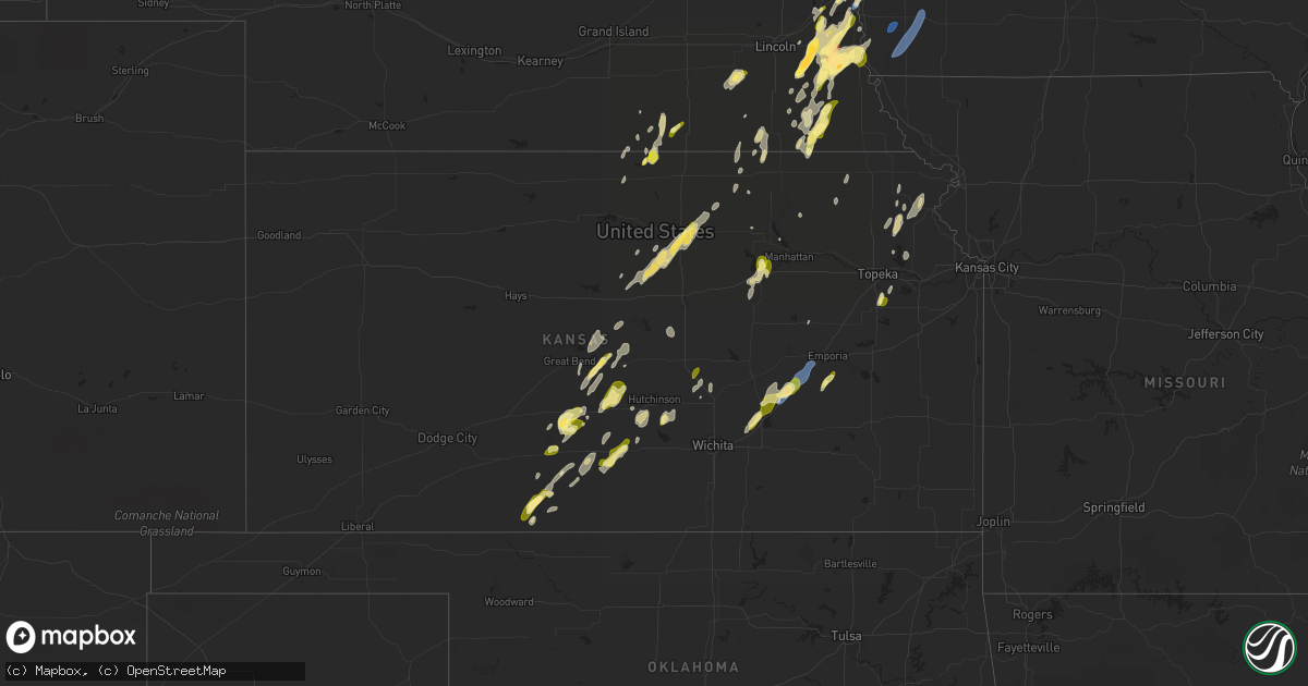
Hail Map in Kansas on April 14, 2023
Get this storm
April 14 map
$229
one time, instant access
Download today. No call, no setup
Keep the $229
Bought the map and want the full workflow? Apply the entire $229 to a subscription within 7 days. None of it is wasted.
Every map, not just this one
This buys you this map. Subscription and you get every map we run, in the markets you choose from a few cities to whole states to nationwide. Plus real-time alerts the moment a storm fires.
Contact data
Name, contact info, occupancy, even credit band for addresses in the footprint. You go from where it hit to who to call.
Become the source they trust
Unlimited branding weather history reports on demand. You already have the documented answer ready for the property owner, and you are the one who showed up with it.
Property data and RoofTrace estimates
Pull up any address you have got, its value and the exact code rules for that jurisdiction, straight from One Click Code. Then RoofTrace estimates the squares, pitch, and roof value, priced the way you price.
Storm reports in Kansas
Kansas
| Date | Description |
|---|---|
| 04/14/20236:58 PM CDT | A local report indicates 1.00 inch wind near 12 W LYONS |
| 04/14/20236:35 PM CDT | Report via the media. Time estimated from radar. |
| 04/14/20235:54 PM CDT | A local report indicates 1.00 inch wind near COTTONWOOD FALLS |
| 04/14/20235:39 PM CDT | Ground white and winds gusting to 50 mph. |
| 04/14/20235:14 PM CDT | A local report indicates 1.00 inch wind near 5 WSW CASSODAY |
| 04/14/20235:10 PM CDT | Report relayed by emergency manager. |
| 04/14/202312:04 AM CDT | A local report indicates 1.00 inch wind near 2 N MOUNDRIDGE |
| 04/13/202310:54 PM CDT | Report from mping: 1-inch tree limbs broken; shingles blown off. |
| 04/13/202310:47 PM CDT | Estimated 40 to 50 mph wind gusts too. |
| 04/13/202310:34 PM CDT | Social media report. |
| 04/13/202310:33 PM CDT | Report from mping: quarter |
| 04/13/202310:31 PM CDT | A local report indicates 1.00 inch wind near 1 N JUNCTION CITY |
| 04/13/20239:29 PM CDT | 90 0round covered. |
| 04/13/20237:48 PM CDT | A local report indicates 1.50 inch wind near PRESTON |
| 04/13/20237:46 PM CDT | Social media post...time estimated based on radar. |
All States Impacted by Hail Map on April 14, 2023
Cities Impacted by Hail Map on April 14, 2023
- Maryville, TN
- New Hill, NC
- Moncure, NC
- Apex, NC
- Holly Springs, NC
- Sanford, NC
- Cary, NC
- Miami, FL
- Towanda, KS
- El Dorado, KS
- Mankato, KS
- Burns, KS
- Cassoday, KS
- Matfield Green, KS
- Webber, KS
- Courtland, KS
- Newport, TN
- Magnolia, NC
- Rolesville, NC
- Louisburg, NC
- Raleigh, NC
- Wake Forest, NC
- Thomasville, NC
- Winston Salem, NC
- Lexington, NC
- Garner, NC
- Longwood, FL
- Apopka, FL
- Altamonte Springs, FL
- Franklinton, NC
- Youngsville, NC
- Bear Creek, NC
- Fuquay Varina, NC
- Mount Olive, NC
- Cottonwood Falls, KS
- Emporia, KS
- Olpe, KS
- Pawnee City, NE
- Onaga, KS
- Elk Creek, NE
- Tecumseh, NE
- Americus, KS
- Allen, KS
- Belvue, KS
- Alma, KS
- Avoca, NE
- Cook, NE
- Otoe, NE
- Wamego, KS
- Centralia, KS
- Weeping Water, NE
- Baileyville, KS
- Adams, NE
- Douglas, NE
- Panama, NE
- Palmyra, NE
- Bennet, NE
- Murdock, NE
- Ashland, NE
- South Bend, NE
- Louisville, NE
- Springfield, NE
- Unadilla, NE
- Gretna, NE
- Elmwood, NE
- Eagle, NE
- Deshler, NE
- Hebron, NE
- Republic, KS
- Ellinwood, KS
- Hudson, KS
- Raymond, KS
- Chase, KS
- Papillion, NE
- Madison, KS
- Burchard, NE
- Summerfield, KS
- Beattie, KS
- Sterling, NE
- Burr, NE
- Syracuse, NE
- Murray, NE
- Nehawka, NE
- Plattsmouth, NE
- Steinauer, NE
- Hartford, KS
- Delphos, KS
- Dorchester, NE
- Crete, NE
- Council Bluffs, IA
- Underwood, IA
- McClelland, IA
- Aurora, KS
- Neola, IA
- Wilmore, KS
- Minden, IA
- Avoca, IA
- Shelby, IA
- Miltonvale, KS
- Concordia, KS
- Cunningham, KS
- Nashville, KS
- Kingman, KS
- Arlington, KS
- Dunbar, NE
- Percival, IA
- Nebraska City, NE
- Union, NE
- Griswold, IA
- Atlantic, IA
- Lewis, IA
- Brayton, IA
- Exira, IA
- Elk Horn, IA
- Byers, KS
- Iuka, KS
- St John, KS
- Stafford, KS
- Macksville, KS
- Ellsworth, KS
- Sun City, KS
- Turon, KS
- Glasco, KS
- Lyons, KS
- Geneseo, KS
- Alum Creek, WV
- Hollenberg, KS
- Endicott, NE
- Morrowville, KS
- Holyrood, KS
- Claflin, KS
- Bushton, KS
- Nelson, NE
- Treynor, IA
- Oak, NE
- Pittsboro, NC
- Davenport, NE
- Ruskin, NE
- Belleville, KS
- Hardy, NE
- Virginia, NE
- Blue Springs, NE
- Linn, KS
- Washington, KS
- High Point, NC
- Greenleaf, KS
- Enfield, NC
- Nashville, NC
- Hollister, NC
- Whitakers, NC
- Warrenton, NC
- Castalia, NC
- Littleton, NC
- Clifton, KS
- Superior, NE
- Coldwater, KS
- Offutt Afb, NE
- Bellevue, NE
- Haviland, KS
- Hanover, KS
- Odell, NE
- Filley, NE
- Lindsborg, KS
- Lincoln, NE
- Lincoln, KS
- Sylvan Grove, KS
- Minneapolis, KS
- Liberty, NE
- Chapman, KS
- Hardy, VA
- Vinton, VA
- Roanoke, VA
- Goodview, VA
- Zebulon, NC
- Wendell, NC
- Tescott, KS
- Beverly, KS
- Logan, IA
- Chapel Hill, NC
- Isabel, KS
- Beatrice, NE
- Diller, NE
- Lake City, KS
- Medicine Lodge, KS
- Sawyer, KS
- Axton, VA
- Elm City, NC
- Rocky Mount, NC
- Guide Rock, NE
- Chatham, VA
- La Vista, NE
- Omaha, NE
- Stoneville, NC
- Pratt, KS
- Plevna, KS
- Sylvia, KS
- Clyde, KS
- Barnard, KS
- Dry Fork, VA
- Blue Ridge, VA
- Mount Gilead, NC
- Wilber, NE
- Western, NE
- Friend, NE
- Keeling, VA
- Lewiston, NE
- Crab Orchard, NE
- Plymouth, NE
- Seven Springs, NC
- Dudley, NC
- Manley, NE
- Talmage, NE
- Ashford, WV
- South Charleston, WV
- Glade Hill, VA
- Hancock, IA
- Oakland, IA
- Coats, KS
- Council Grove, KS
- Belle Glade, FL
- Java, VA
- Gretna, VA
- Blairs, VA
- Cedar Point, KS
- Battleboro, NC
- Callands, VA
- Goldsboro, NC
- Pikeville, NC
- Beloit, KS
- Mayodan, NC
- Morrisville, NC
- Trinity, NC
- Fort Riley, KS
- Riley, KS
- Milford, KS
- Junction City, KS
- Moundridge, KS
- Galva, KS
- Canton, KS
- Sterling, KS
- Abbyville, KS
- Alden, KS
- Carbondale, KS
- Overbrook, KS
- Berryton, KS
- Farragut, IA
- Shenandoah, IA
- Imogene, IA
- Sidney, IA
- Red Oak, IA
- Essex, IA
- Emerson, IA
- Malvern, IA
- Hastings, IA
- Boerne, TX
- Comfort, TX
- Bandera, TX
- Pipe Creek, TX
- Haven, KS
- Bulverde, TX
- Bergheim, TX
- San Antonio, TX
- Spring Branch, TX
- Kendalia, TX
- Canyon Lake, TX
- New Braunfels, TX
- San Marcos, TX
- Kyle, TX
- Maxwell, TX
- Lockhart, TX
- Everest, KS
- Effingham, KS
- Seneca, KS
- Falun, KS
- Marquette, KS
- Hutchinson, KS
- Partridge, KS
- Carson, IA
- Ozawkie, KS
- Oskaloosa, KS
- Horton, KS
- Bridgewater, IA
- Leonardville, KS
- Meriden, KS
- Westmoreland, KS
- Brackettville, TX
- Atchison, KS
- Lancaster, KS
- Corning, KS
- Holton, KS
- Valley Falls, KS
- Cummings, KS
- Hiawatha, KS
- Woodbine, KS
- Hesston, KS
- Newton, KS
- Burrton, KS
- Barksdale, TX
- Uvalde, TX
- Camp Wood, TX
- Denison, KS
- Great Bend, KS
- Leakey, TX
- Rio Frio, TX
- Pretty Prairie, KS
- Manhattan, KS
- Rocksprings, TX
- Lorraine, KS
- Winchester, KS
- Walnut, IA
- Thurman, IA
- Nortonville, KS
- Muscotah, KS
- Fulshear, TX
- Wallis, TX
- Del Rio, TX
- Richmond, TX
- Halstead, KS
- Rosenberg, TX
- Houston, TX
- Sugar Land, TX


