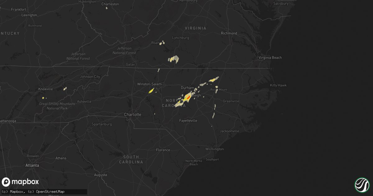
Hail Map on April 14, 2023
Get this storm
April 14 map
$229
one time, instant access
Download today. No call, no setup
Keep the $229
Bought the map and want the full workflow? Apply the entire $229 to a subscription within 7 days. None of it is wasted.
Every map, not just this one
This buys you this map. Subscription and you get every map we run, in the markets you choose from a few cities to whole states to nationwide. Plus real-time alerts the moment a storm fires.
Contact data
Name, contact info, occupancy, even credit band for addresses in the footprint. You go from where it hit to who to call.
Become the source they trust
Unlimited branding weather history reports on demand. You already have the documented answer ready for the property owner, and you are the one who showed up with it.
Property data and RoofTrace estimates
Pull up any address you have got, its value and the exact code rules for that jurisdiction, straight from One Click Code. Then RoofTrace estimates the squares, pitch, and roof value, priced the way you price.
States Impacted by Hail Map on April 14, 2023
Storm reports
Florida
| Date | Description |
|---|---|
| 04/14/20233:30 PM CDT | Social media report photo of a large tree uprooted/knocked down across the street from wesley mathews elementary school as a severe thunderstorm moved through the area. |
| 04/14/20233:24 PM CDT | Earthnetworks bpjsm belen jesuit preparatory school mesonet reported a wind gust of 61mph at 4:24pm as a severe thunderstorm moved through the area. Site elevation is 5 |
| 04/14/20232:16 PM CDT | Emergency manager reports a large tree down... Causing power line damage in longwood near the intersection of markham woods rd and ee williamson rd. Time estimated via |
| 04/14/20232:16 PM CDT | Public report of a tree down near the springwood village condo complex. Some fencing was also damaged. Time estimated via radar. |
Colorado
| Date | Description |
|---|---|
| 04/14/20234:10 PM CDT | Asos station kdro durango la plata cnty airport. |
| 04/14/20231:27 PM CDT | Mesonet station co101 082w023 basalt-holland hills. |
Tennessee
| Date | Description |
|---|---|
| 04/14/20232:35 PM CDT | A local report indicates 1.00 inch wind near NEWPORT |
| 04/14/202312:16 PM CDT | Social media report of 0.75-to-1.00-inch hail south of maryville. Time and location based on radar. |
Iowa
| Date | Description |
|---|---|
| 04/13/202310:15 PM CDT | A local report indicates 68 MPH wind near 4 E ESSEX |
| 04/13/202310:14 PM CDT | A local report indicates 63 MPH wind near 2 W RED OAK |
| 04/13/20239:57 PM CDT | Report from mping: 3-inch tree limbs broken; power poles broken. |
| 04/13/20239:57 PM CDT | Report from mping: 3-inch tree limbs broken; po |
| 04/13/20239:45 PM CDT | Personal weather station. |
| 04/13/20239:25 PM CDT | Personal weather station. |
Kansas
| Date | Description |
|---|---|
| 04/14/20236:58 PM CDT | A local report indicates 1.00 inch wind near 12 W LYONS |
| 04/14/20236:35 PM CDT | Report via the media. Time estimated from radar. |
| 04/14/20235:54 PM CDT | A local report indicates 1.00 inch wind near COTTONWOOD FALLS |
| 04/14/20235:39 PM CDT | Ground white and winds gusting to 50 mph. |
| 04/14/20235:14 PM CDT | A local report indicates 1.00 inch wind near 5 WSW CASSODAY |
| 04/14/20235:10 PM CDT | Report relayed by emergency manager. |
| 04/14/202312:04 AM CDT | A local report indicates 1.00 inch wind near 2 N MOUNDRIDGE |
| 04/13/202310:54 PM CDT | Report from mping: 1-inch tree limbs broken; shingles blown off. |
| 04/13/202310:47 PM CDT | Estimated 40 to 50 mph wind gusts too. |
| 04/13/202310:34 PM CDT | Social media report. |
| 04/13/202310:33 PM CDT | Report from mping: quarter |
| 04/13/202310:31 PM CDT | A local report indicates 1.00 inch wind near 1 N JUNCTION CITY |
| 04/13/20239:29 PM CDT | 90 0round covered. |
| 04/13/20237:48 PM CDT | A local report indicates 1.50 inch wind near PRESTON |
| 04/13/20237:46 PM CDT | Social media post...time estimated based on radar. |
Nebraska
| Date | Description |
|---|---|
| 04/14/20236:55 PM CDT | A local report indicates 1.00 inch wind near PAPILLION |
| 04/14/20236:50 PM CDT | Report from mping: quarter |
| 04/14/20236:44 PM CDT | A local report indicates 1.75 inch wind near 1 SSE PALMYRA |
| 04/14/20236:40 PM CDT | A local report indicates 1.75 inch wind near 3 SW PALMYRA |
| 04/14/20236:40 PM CDT | Report from mping: quarter |
| 04/14/20236:19 PM CDT | Report from mping: quarter |
| 04/14/20236:05 PM CDT | Corrects previous hail report from deshler. Fb report. |
| 04/13/20239:10 PM CDT | Semi truck blown off the road at the intersection of us 75 and nebraska highway 67. |
| 04/13/20239:01 PM CDT | A local report indicates 1.75 inch wind near 5 S SYRACUSE |
| 04/13/20239:00 PM CDT | A local report indicates 60 MPH wind near 2 SSE LORTON VILLAGE |
| 04/13/20238:37 PM CDT | Report from mping: 1-inch tree limbs broken; shingles blown off. |
| 04/13/20238:02 PM CDT | Tree trunks snapped sheds damaged and destroyed on plum road near s 108th rd.ar 108. |
| 04/13/20238:00 PM CDT | Car lifted and spun around near us 77 and nebraska highway 8. Signs blown down. Power lines down. |
| 04/13/20238:00 PM CDT | Part of a roof of a home blown off near hwy 8 and s 66th rd. |
| 04/13/20237:54 PM CDT | Report from mping: quarter |
| 04/13/20237:36 PM CDT | Wind gust to 58knots at offutt air force base. |
| 04/13/20237:28 PM CDT | A local report indicates 1.75 inch wind near 1 NNE SYRACUSE |
| 04/13/20237:23 PM CDT | A local report indicates 1.25 inch wind near 6.5 S BURCHARD |
| 04/13/20237:07 PM CDT | A local report indicates 1.00 inch wind near 6 S BURCHARD |
| 04/13/20237:04 PM CDT | Report from mping: half dollar |
North Carolina
| Date | Description |
|---|---|
| 04/14/20235:55 PM CDT | Railroad crossing arm damaged by thunderstorm wind gusts. |
| 04/14/20235:47 PM CDT | Report of a couple trees down in the hollister area. |
| 04/14/20234:33 PM CDT | Several reports of quarter to half dollar size hail relayed from media. |
| 04/14/20233:44 PM CDT | A large tree down along carbonton road. Time estimated by radar. |
| 04/14/20233:42 PM CDT | Large tree down near the intersection of steel bridge road and variety lane. Time estimated by radar. |
| 04/14/20233:24 PM CDT | Trained spotter reports multiple large branches down in a residential area. Time estimated via radar. |
| 04/14/20233:22 PM CDT | Ping pong ball-sized hail observed in cary... Nc. |
| 04/14/20233:10 PM CDT | Quarter size hail observed at boxcar way near apex... Nc. |
| 04/14/20233:10 PM CDT | Member of public measured up to 1.5 inch hail in sw cary. |
| 04/14/20233:08 PM CDT | Public report of estimated half dollar |
| 04/14/20233:03 PM CDT | Nws employee reports quarter sized hail on whistling quail rd in apex. Time estimated via radar. |
| 04/14/20233:02 PM CDT | Quarter size hail reported in downtown apex. |
| 04/14/20233:01 PM CDT | Trained spotter sent picture of golf ball sized hail measured with ruler. Time estimated by radar. |
| 04/14/20232:26 PM CDT | Photo of quarter sized hail on river forks rd posted on social media. Time estimated via radar. |
Cities Impacted by Hail Map on April 14, 2023
- Maryville, TN
- New Hill, NC
- Moncure, NC
- Apex, NC
- Holly Springs, NC
- Sanford, NC
- Cary, NC
- Miami, FL
- Towanda, KS
- El Dorado, KS
- Mankato, KS
- Burns, KS
- Cassoday, KS
- Matfield Green, KS
- Webber, KS
- Courtland, KS
- Newport, TN
- Magnolia, NC
- Rolesville, NC
- Louisburg, NC
- Raleigh, NC
- Wake Forest, NC
- Thomasville, NC
- Winston Salem, NC
- Lexington, NC
- Garner, NC
- Longwood, FL
- Apopka, FL
- Altamonte Springs, FL
- Franklinton, NC
- Youngsville, NC
- Bear Creek, NC
- Fuquay Varina, NC
- Mount Olive, NC
- Cottonwood Falls, KS
- Emporia, KS
- Olpe, KS
- Pawnee City, NE
- Onaga, KS
- Elk Creek, NE
- Tecumseh, NE
- Americus, KS
- Allen, KS
- Belvue, KS
- Alma, KS
- Avoca, NE
- Cook, NE
- Otoe, NE
- Wamego, KS
- Centralia, KS
- Weeping Water, NE
- Baileyville, KS
- Adams, NE
- Douglas, NE
- Panama, NE
- Palmyra, NE
- Bennet, NE
- Murdock, NE
- Ashland, NE
- South Bend, NE
- Louisville, NE
- Springfield, NE
- Unadilla, NE
- Gretna, NE
- Elmwood, NE
- Eagle, NE
- Deshler, NE
- Hebron, NE
- Republic, KS
- Ellinwood, KS
- Hudson, KS
- Raymond, KS
- Chase, KS
- Papillion, NE
- Madison, KS
- Burchard, NE
- Summerfield, KS
- Beattie, KS
- Sterling, NE
- Burr, NE
- Syracuse, NE
- Murray, NE
- Nehawka, NE
- Plattsmouth, NE
- Steinauer, NE
- Hartford, KS
- Delphos, KS
- Dorchester, NE
- Crete, NE
- Council Bluffs, IA
- Underwood, IA
- McClelland, IA
- Aurora, KS
- Neola, IA
- Wilmore, KS
- Minden, IA
- Avoca, IA
- Shelby, IA
- Miltonvale, KS
- Concordia, KS
- Cunningham, KS
- Nashville, KS
- Kingman, KS
- Arlington, KS
- Dunbar, NE
- Percival, IA
- Nebraska City, NE
- Union, NE
- Griswold, IA
- Atlantic, IA
- Lewis, IA
- Brayton, IA
- Exira, IA
- Elk Horn, IA
- Byers, KS
- Iuka, KS
- St John, KS
- Stafford, KS
- Macksville, KS
- Ellsworth, KS
- Sun City, KS
- Turon, KS
- Glasco, KS
- Lyons, KS
- Geneseo, KS
- Alum Creek, WV
- Hollenberg, KS
- Endicott, NE
- Morrowville, KS
- Holyrood, KS
- Claflin, KS
- Bushton, KS
- Nelson, NE
- Treynor, IA
- Oak, NE
- Pittsboro, NC
- Davenport, NE
- Ruskin, NE
- Belleville, KS
- Hardy, NE
- Virginia, NE
- Blue Springs, NE
- Linn, KS
- Washington, KS
- High Point, NC
- Greenleaf, KS
- Enfield, NC
- Nashville, NC
- Hollister, NC
- Whitakers, NC
- Warrenton, NC
- Castalia, NC
- Littleton, NC
- Clifton, KS
- Superior, NE
- Coldwater, KS
- Offutt Afb, NE
- Bellevue, NE
- Haviland, KS
- Hanover, KS
- Odell, NE
- Filley, NE
- Lindsborg, KS
- Lincoln, NE
- Lincoln, KS
- Sylvan Grove, KS
- Minneapolis, KS
- Liberty, NE
- Chapman, KS
- Hardy, VA
- Vinton, VA
- Roanoke, VA
- Goodview, VA
- Zebulon, NC
- Wendell, NC
- Tescott, KS
- Beverly, KS
- Logan, IA
- Chapel Hill, NC
- Isabel, KS
- Beatrice, NE
- Diller, NE
- Lake City, KS
- Medicine Lodge, KS
- Sawyer, KS
- Axton, VA
- Elm City, NC
- Rocky Mount, NC
- Guide Rock, NE
- Chatham, VA
- La Vista, NE
- Omaha, NE
- Stoneville, NC
- Pratt, KS
- Plevna, KS
- Sylvia, KS
- Clyde, KS
- Barnard, KS
- Dry Fork, VA
- Blue Ridge, VA
- Mount Gilead, NC
- Wilber, NE
- Western, NE
- Friend, NE
- Keeling, VA
- Lewiston, NE
- Crab Orchard, NE
- Plymouth, NE
- Seven Springs, NC
- Dudley, NC
- Manley, NE
- Talmage, NE
- Ashford, WV
- South Charleston, WV
- Glade Hill, VA
- Hancock, IA
- Oakland, IA
- Coats, KS
- Council Grove, KS
- Belle Glade, FL
- Java, VA
- Gretna, VA
- Blairs, VA
- Cedar Point, KS
- Battleboro, NC
- Callands, VA
- Goldsboro, NC
- Pikeville, NC
- Beloit, KS
- Mayodan, NC
- Morrisville, NC
- Trinity, NC
- Fort Riley, KS
- Riley, KS
- Milford, KS
- Junction City, KS
- Moundridge, KS
- Galva, KS
- Canton, KS
- Sterling, KS
- Abbyville, KS
- Alden, KS
- Carbondale, KS
- Overbrook, KS
- Berryton, KS
- Farragut, IA
- Shenandoah, IA
- Imogene, IA
- Sidney, IA
- Red Oak, IA
- Essex, IA
- Emerson, IA
- Malvern, IA
- Hastings, IA
- Boerne, TX
- Comfort, TX
- Bandera, TX
- Pipe Creek, TX
- Haven, KS
- Bulverde, TX
- Bergheim, TX
- San Antonio, TX
- Spring Branch, TX
- Kendalia, TX
- Canyon Lake, TX
- New Braunfels, TX
- San Marcos, TX
- Kyle, TX
- Maxwell, TX
- Lockhart, TX
- Everest, KS
- Effingham, KS
- Seneca, KS
- Falun, KS
- Marquette, KS
- Hutchinson, KS
- Partridge, KS
- Carson, IA
- Ozawkie, KS
- Oskaloosa, KS
- Horton, KS
- Bridgewater, IA
- Leonardville, KS
- Meriden, KS
- Westmoreland, KS
- Brackettville, TX
- Atchison, KS
- Lancaster, KS
- Corning, KS
- Holton, KS
- Valley Falls, KS
- Cummings, KS
- Hiawatha, KS
- Woodbine, KS
- Hesston, KS
- Newton, KS
- Burrton, KS
- Barksdale, TX
- Uvalde, TX
- Camp Wood, TX
- Denison, KS
- Great Bend, KS
- Leakey, TX
- Rio Frio, TX
- Pretty Prairie, KS
- Manhattan, KS
- Rocksprings, TX
- Lorraine, KS
- Winchester, KS
- Walnut, IA
- Thurman, IA
- Nortonville, KS
- Muscotah, KS
- Fulshear, TX
- Wallis, TX
- Del Rio, TX
- Richmond, TX
- Halstead, KS
- Rosenberg, TX
- Houston, TX
- Sugar Land, TX