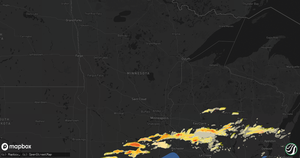
Hail Map in Minnesota on April 13, 2026
Get this storm
April 13 map
$229
one time, instant access
Download today. No call, no setup
Keep the $229
Bought the map and want the full workflow? Apply the entire $229 to a subscription within 7 days. None of it is wasted.
Every map, not just this one
This buys you this map. Subscription and you get every map we run, in the markets you choose from a few cities to whole states to nationwide. Plus real-time alerts the moment a storm fires.
Contact data
Name, contact info, occupancy, even credit band for addresses in the footprint. You go from where it hit to who to call.
Become the source they trust
Unlimited branding weather history reports on demand. You already have the documented answer ready for the property owner, and you are the one who showed up with it.
Property data and RoofTrace estimates
Pull up any address you have got, its value and the exact code rules for that jurisdiction, straight from One Click Code. Then RoofTrace estimates the squares, pitch, and roof value, priced the way you price.
Storm reports in Minnesota
Minnesota
| Date | Description |
|---|---|
| 04/13/20266:55 PM CDT | A local report indicates 2.50 inch wind near 2 ESE Hanska |
| 04/13/20266:54 PM CDT | Hail for about 5-10 minutes up to the size of ping pong balls... Most of them smaller. Moderate rain followed hail... And everything was done by about 715 pm. |
| 04/13/20266:50 PM CDT | A local report indicates 1.25 inch wind near Windom |
| 04/13/20266:46 PM CDT | Spotter report of golf ball sized hail. |
| 04/13/20266:45 PM CDT | A local report indicates 1.25 inch wind near 1 S Windom |
| 04/13/20266:45 PM CDT | A local report indicates 3.30 inch wind near Dennison |
| 04/13/20266:45 PM CDT | A local report indicates 1.75 inch wind near 5 NW La Salle |
| 04/13/20266:44 PM CDT | Report from mping: tennis ball |
| 04/13/20266:43 PM CDT | A local report indicates 1.00 inch wind near 6 S Fairmont |
| 04/13/20266:41 PM CDT | A local report indicates 1.50 inch wind near Hanska |
| 04/13/20266:40 PM CDT | A local report indicates 2.00 inch wind near 2 W Mountain Lake |
| 04/13/20266:34 PM CDT | Report from mping: golf ball |
| 04/13/20266:31 PM CDT | A local report indicates 1.50 inch wind near 3 SE Delft |
| 04/13/20266:26 PM CDT | A local report indicates 1.00 inch wind near 2 SE Wabasha |
| 04/13/20266:25 PM CDT | Multiple reports from storm chasers... Fire department... Law enforcement. Tornado still on ground at 632 pm. |
| 04/13/20266:25 PM CDT | Updates previous tornado report from 7 wsw amboy. Multiple reports from storm chasers... Fire department... Law enforcement. Tornado still on ground at 632 pm. Farm out |
| 04/13/20266:22 PM CDT | A local report indicates 1.00 inch wind near Delft |
| 04/13/20266:22 PM CDT | A local report indicates 1.00 inch wind near Wabasha |
| 04/13/20266:22 PM CDT | A local report indicates 1.50 inch wind near 1 NNE Wabasha |
| 04/13/20266:21 PM CDT | A local report indicates 2.00 inch wind near 4 N Windom |
| 04/13/20266:20 PM CDT | Social media report with pictures and ruler. |
| 04/13/20266:17 PM CDT | Report from mping: baseball |
| 04/13/20266:15 PM CDT | A local report indicates 2.00 inch wind near 5 NW Windom |
| 04/13/20266:13 PM CDT | Report from mping: tennis ball |
| 04/13/20266:12 PM CDT | Report from mping: ping pong ball |
| 04/13/20266:04 PM CDT | Report from mping: half dollar |
| 04/13/20266:04 PM CDT | A local report indicates 1.75 inch wind near Lewisville |
| 04/13/20266:03 PM CDT | Report from mping: quarter |
| 04/13/20266:00 PM CDT | A local report indicates 2.00 inch wind near Lake City |
| 04/13/20266:00 PM CDT | A local report indicates 1.50 inch wind near 1 NNW Dundee |
| 04/13/20265:59 PM CDT | A local report indicates 1.00 inch wind near 2 NW Dundee |
| 04/13/20265:59 PM CDT | Report from mping: quarter |
| 04/13/20265:54 PM CDT | A local report indicates 1.50 inch wind near 6 WSW Lewisville |
| 04/13/20265:52 PM CDT | Report from mping: hen egg |
| 04/13/20265:51 PM CDT | Report from mping: quarter |
| 04/13/20265:50 PM CDT | Mesonet station mn143 u.s.63 - lake city - mp 62.9. |
| 04/13/20265:50 PM CDT | A local report indicates 2.00 inch wind near 2 SSW Frontenac Station |
| 04/13/20265:48 PM CDT | A local report indicates 2.00 inch wind near 3 E Nicollet |
| 04/13/20265:45 PM CDT | A local report indicates 2.00 inch wind near 8 W Lake City |
| 04/13/20265:43 PM CDT | . |
| 04/13/20265:43 PM CDT | A local report indicates 2.50 inch wind near 4 ENE Bellechester |
| 04/13/20265:38 PM CDT | A local report indicates 1.75 inch wind near 2 N Ormsby |
| 04/13/20265:35 PM CDT | A local report indicates 1.75 inch wind near Odin |
| 04/13/20265:34 PM CDT | Report from mping: tennis ball |
| 04/13/20265:33 PM CDT | Report from mping: hen egg |
| 04/13/20264:45 PM CDT | Delayed report relayed with a photo via nwschat. |
| 04/13/20264:25 PM CDT | A local report indicates 1.50 inch wind near 2 NE Dennison |
| 04/13/20264:00 PM CDT | Reported relayed via slack. |
| 04/13/20263:57 PM CDT | Report from mping: quarter |
| 04/13/20263:56 PM CDT | Report from mping: ping pong ball |
| 04/13/20263:55 PM CDT | Report from mping: ping pong ball |
| 04/13/20263:53 PM CDT | A local report indicates 3.00 inch wind near 4 NNE Faribault |
| 04/13/20263:48 PM CDT | A local report indicates 2.00 inch wind near 4 NE Faribault |
| 04/13/20263:39 PM CDT | A local report indicates 1.50 inch wind near 1 SW Faribault |
| 04/13/20263:35 PM CDT | Egg sized hail reported via slack. Time estimated via radar. |
| 04/13/20263:27 PM CDT | Report from mping: ping pong ball |
| 04/13/20263:25 PM CDT | A local report indicates 1.00 inch wind near 1 SW Faribault |
| 04/13/20263:25 PM CDT | Corrects previous hail report from 2 wsw faribault. Egg sized hail reported via slack. Time estimated via radar. |
| 04/12/20269:47 PM CDT | A local report indicates 59 MPH wind near 1 NW Carimona |
| 04/12/20269:24 PM CDT | A local report indicates 58 MPH wind near 1 W Spring Valley |
| 04/12/20268:50 PM CDT | A local report indicates 1.00 inch wind near 1 N Jackson |
| 04/12/20268:49 PM CDT | A local report indicates 1.00 inch wind near 2 N Jackson |
| 04/12/20268:32 PM CDT | Lots of dime to quarter size hail. |
| 04/12/20268:29 PM CDT | Most hail stones were penny to quarter sized... But some as big as hen eggs. |
| 04/12/20268:28 PM CDT | A local report indicates 3.00 inch wind near Lake Crystal |
| 04/12/20268:21 PM CDT | A local report indicates 1.00 inch wind near 5 S Okabena |
| 04/12/20268:20 PM CDT | A local report indicates 1.25 inch wind near 5 S Okabena |
| 04/12/20268:09 PM CDT | Report from mping: ping pong ball |
| 04/12/20268:05 PM CDT | Trained spotter relayed tornado video via social media. Location and time estimated by radar. |
| 04/12/20268:05 PM CDT | Corrects previous tornado report from 3 ese matawan. Trained spotter relayed tornado video via social media. Location and time estimated by radar and from spotter damag |
| 04/12/20268:04 PM CDT | A local report indicates 1.50 inch wind near 5 W West Concord |
| 04/12/20267:46 PM CDT | A local report indicates 1.00 inch wind near 7 WNW Brewster |
| 04/12/20267:45 PM CDT | Report from mping: hen egg+ |
| 04/12/20267:40 PM CDT | Report from mping: quarter |
| 04/12/20267:39 PM CDT | A local report indicates 1.50 inch wind near 3 SSW Skyline |
| 04/12/20267:35 PM CDT | A local report indicates 1.00 inch wind near Goodhue |
| 04/12/20267:34 PM CDT | Time estimated from radar. |
| 04/12/20267:29 PM CDT | A local report indicates 1.50 inch wind near 6 NNE Rushmore |
| 04/12/20267:20 PM CDT | Tornado on video. Location and time approximate. |
| 04/12/20267:18 PM CDT | A local report indicates 2.00 inch wind near 6 WSW Lewisville |
| 04/12/20267:17 PM CDT | Report from mping: golf ball |
| 04/12/20267:16 PM CDT | A local report indicates 3.50 inch wind near Lake Crystal |
| 04/12/20267:15 PM CDT | A local report indicates 3.00 inch wind near Lake Crystal |
| 04/12/20267:15 PM CDT | Photo with measured hail. |
| 04/12/20267:15 PM CDT | A local report indicates 2.75 inch wind near 4 WNW Lake Crystal |
| 04/12/20267:10 PM CDT | A local report indicates 2.00 inch wind near 2 SW Judson |
| 04/12/20267:02 PM CDT | A local report indicates 2.75 inch wind near 4 N Madelia |
All States Impacted by Hail Map on April 13, 2026
Cities Impacted by Hail Map on April 13, 2026
- Hamilton, IL
- Nauvoo, IL
- Bradford, IL
- Wyoming, IL
- Henry, IL
- Sparland, IL
- Clinton, IA
- Bryant, IA
- Wenona, IL
- Putnam, IL
- Streator, IL
- Magnolia, IL
- Lacon, IL
- Hennepin, IL
- Sabula, IA
- McNabb, IL
- Granville, IL
- Sterling, IL
- Peru, IL
- Standard, IL
- Oglesby, IL
- Ottawa, IL
- Cabery, IL
- Dwight, IL
- Buckingham, IL
- Odell, IL
- Emington, IL
- Campus, IL
- Utica, IL
- Marseilles, IL
- Reddick, IL
- Herscher, IL
- Gardner, IL
- Union Hill, IL
- Bonfield, IL
- Essex, IL
- Wilmington, IL
- Kankakee, IL
- Chebanse, IL
- Martinton, IL
- Saint Anne, IL
- Papineau, IL
- Beaverville, IL
- Weston, WY
- Grant Park, IL
- Momence, IL
- Broadus, MT
- Hammond, MT
- Bourbonnais, IL
- Moorcroft, WY
- Hulett, WY
- Lowell, IN
- Alzada, MT
- Watseka, IL
- Donovan, IL
- Dryden, TX
- Hillpoint, WI
- Loganville, WI
- La Valle, WI
- Lime Ridge, WI
- Reedsburg, WI
- Morocco, IN
- Richland Center, WI
- Pembroke Township, IL
- Cazenovia, WI
- Faribault, MN
- Capitol, MT
- Northfield, MN
- Nerstrand, MN
- Fort Stockton, TX
- Ekalaka, MT
- Dennison, MN
- Rensselaer, IN
- Fair Oaks, IN
- Mount Ayr, IN
- Kenyon, MN
- Cannon Falls, MN
- Tripp, SD
- Olivet, SD
- Baraboo, WI
- Camp Crook, SD
- Goodhue, MN
- Portage, WI
- Burns, KS
- Menno, SD
- Freeman, SD
- Cedar Point, KS
- Anson, TX
- Red Wing, MN
- Welch, MN
- Stevens Point, WI
- Stockholm, WI
- Pepin, WI
- Buffalo, SD
- Midkiff, TX
- Sweetwater, TX
- Roby, TX
- Sylvester, TX
- McCaulley, TX
- Custer, WI
- Rosholt, WI
- Cottonwood Falls, KS
- Hatley, WI
- Howe, IN
- Plum City, WI
- Spencer, WI
- Loyal, WI
- Granton, WI
- Wittenberg, WI
- Eland, WI
- Sturgis, MI
- Neillsville, WI
- Marshfield, WI
- Big Lake, TX
- Maiden Rock, WI
- Nelson, WI
- Strong City, KS
- Durand, WI
- Marion, SD
- Constantine, MI
- Three Rivers, MI
- Emporia, KS
- Centreville, MI
- Mendon, MI
- Bowler, WI
- Burr Oak, MI
- Merrillan, WI
- Wisconsin Rapids, WI
- Pittsville, WI
- Stratford, WI
- Tigerton, WI
- Vesper, WI
- Hamlin, TX
- Haskell, TX
- Wheeler, WI
- Weinert, TX
- Chili, WI
- Garden City, TX
- Eleva, WI
- Strum, WI
- Kingsley, IA
- Moville, IA
- Cornell, WI
- Bronson, MI
- Birnamwood, WI
- Parker, SD
- Holcombe, WI
- Odin, MN
- Lake City, MN
- Humbird, WI
- Bloomer, WI
- Lonsdale, MN
- New Prague, MN
- Zumbrota, MN
- Montgomery, MN
- Kilkenny, MN
- Throckmorton, TX
- Americus, KS
- Arpin, WI
- Sterling City, TX
- Columbia City, IN
- Roanoke, IN
- Fort Wayne, IN
- Arcola, IN
- Gilman, WI
- Saint James, MN
- Butterfield, MN
- Ormsby, MN
- Union Center, SD
- Nicollet, MN
- Le Mars, IA
- Remsen, IA
- Hinton, IA
- Marathon, WI
- Mosinee, WI
- Mondovi, WI
- Rudolph, WI
- Fulda, MN
- Mankato, MN
- Boyd, WI
- Osseo, WI
- Frontenac, MN
- Marcus, IA
- Stamford, TX
- Reading, KS
- Saint Peter, MN
- Sheldon, WI
- Wausau, WI
- Lewisville, MN
- Ruthven, IA
- Dickens, IA
- Pierson, IA
- Le Center, MN
- Seymour, TX
- Heron Lake, MN
- Comfrey, MN
- Darfur, MN
- Estherville, IA
- Granville, IA
- Paullina, IA
- Avoca, TX
- Medford, WI
- Sioux Falls, SD
- Tea, SD
- Lennox, SD
- Kasota, MN
- Ossian, IN
- Yoder, IN
- Decatur, IN
- Hoagland, IN
- Monroeville, IN
- New Haven, IN
- Woodburn, IN
- Grabill, IN
- Wabasha, MN
- Reads Landing, MN
- Amboy, MN
- Truman, MN
- Vernon Center, MN
- Hanska, MN
- Sleepy Eye, MN
- Auburndale, WI
- Webster, MN
- Windom, MN
- Edgar, WI
- Plainwell, MI
- Armstrong, IA
- Schofield, WI
- Dundas, MN
- Plover, WI
- Osage City, KS
- Westboro, WI
- Archer, IA
- Graettinger, IA
- Cleveland, MN
- Amherst Junction, WI
- Amherst, WI
- Scandinavia, WI
- Nelsonville, WI
- Iola, WI
- Convoy, OH
- Antwerp, OH
- Payne, OH
- Paulding, OH
- Scott, OH
- Haviland, OH
- Cecil, OH
- Alma, WI
- Fall Creek, WI
- Kellogg, MN
- Westbrook, TX
- Melvin, IA
- Ocheyedan, IA
- Arkansaw, WI
- Delton, MI
- Council Grove, KS
- Dolliver, IA
- Emmetsburg, IA
- Valley Springs, SD
- Fountain City, WI
- Cochrane, WI
- Elmdale, KS
- Loraine, TX
- Colorado City, TX
- Lyndon, KS
- Sanborn, IA
- Primghar, IA
- Vassar, KS
- Hastings, MI
- Grover Hill, OH
- Cloverdale, OH
- Oakwood, OH
- Latty, OH
- Melrose, OH
- Defiance, OH
- Good Thunder, MN
- Madelia, MN
- Roscoe, TX
- Whitehall, WI
- Altura, MN
- Morristown, MN
- Waseca, MN
- Brandon, SD
- Chancellor, SD
- Admire, KS
- Cleghorn, IA
- Bingham Lake, MN
- Mountain Lake, MN
- Augusta, WI
- Janesville, MN
- Allen, KS
- Beaver Creek, MN
- Milladore, WI
- Madison Lake, MN
- Lake Park, IA
- Harris, IA
- Arcadia, WI
- Hartford, SD
- Fairchild, WI
- Cherokee, IA
- Meriden, IA
- Spencer, IA
- Royal, IA
- Fairmont, MN
- Wallingford, IA
- Ceylon, MN
- Lebo, KS
- Melvern, KS
- Lake Crystal, MN
- Quenemo, KS
- Waterville, MN
- Elysian, MN
- Ashton, IA
- Sibley, IA
- Medford, MN
- Owatonna, MN
- Alma Center, WI
- Marion, WI
- Manawa, WI
- Ogdensburg, WI
- Hartley, IA
- Junction City, WI
- Larrabee, IA
- Independence, WI
- Peterson, IA
- Athens, WI
- Mapleton, MN
- Swea City, IA
- Granada, MN
- Humboldt, KS
- Ringsted, IA
- Springfield, MN
- Terril, IA
- Milford, IA
- Luverne, MN
- Eskridge, KS
- Piqua, KS
- Bear Creek, WI
- Clintonville, WI
- Continental, OH
- Freeport, MI
- Woodland, MI
- Lake Odessa, MI
- Vermontville, MI
- Hermleigh, TX
- Stanley, WI
- Willard, WI
- Garden City, MN
- New London, WI
- Spalding, NE
- New Ulm, MN
- Spirit Lake, IA
- Arnolds Park, IA
- Winnebago, MN
- Hixton, WI
- Scranton, KS
- Burlingame, KS
- Magnolia, MN
- Iola, KS
- Elmore, MN
- Blue Earth, MN
- Pomona, KS
- Sutherland, IA
- Embarrass, WI
- Aurelia, IA
- Linn Grove, IA
- Overbrook, KS
- Everly, IA
- Sunfield, MI
- Portland, MI
- Ottawa, KS
- Minnesota Lake, MN
- Shiocton, WI
- Blair, WI
- Ettrick, WI
- Ledyard, IA
- Rushmore, MN
- Rotan, TX
- Adrian, MN
- Merrill, WI
- La Harpe, KS
- Moran, KS
- Wanamingo, MN
- Primrose, NE
- Oregon, OH
- Carbondale, KS
- McComb, OH
- Lismore, MN
- Wilmont, MN
- Westphalia, MI
- Pewamo, MI
- Williamsburg, KS
- Waldorf, MN
- Green Bay, WI
- Kincaid, KS
- Blue Mound, KS
- Claremont, MN
- West Concord, MN
- Reading, MN
- Burt, IA
- Lone Rock, IA
- Taylor, WI
- Webb, IA
- Sioux Rapids, IA
- Greenville, IA
- De Pere, WI
- Buffalo Center, IA
- Mazeppa, MN
- Oneida, WI
- Bonduel, WI
- Black Creek, WI
- Baldwin City, KS
- Curtice, OH
- Greenwood, WI
- Bancroft, IA
- Fenton, IA
- Bronson, KS
- Galesville, WI
- Seymour, WI
- Caroline, WI
- Leopolis, WI
- Pemberton, MN
- Worthington, MN
- Brewster, MN
- Melrose, WI
- Black River Falls, WI
- Lawrence, KS
- Saint Johns, MI
- Fowler, MI
- Pulaski, WI
- Hewitt, WI
- New Franken, WI
- Millbury, OH
- Frost, MN
- Bricelyn, MN
- Rake, IA
- Thompson, IA
- Ayrshire, IA
- Gillett Grove, IA
- Titonka, IA
- Aspermont, TX
- Eagle, MI
- Grand Ledge, MI
- Wellsville, KS
- Trimont, MN
- Lyons, MI
- Luxemburg, WI
- Round Lake, MN
- Hospers, IA
- Dodge Center, MN
- Shawano, WI
- Toledo, OH
- Rantoul, KS
- Paola, KS
- Edgerton, KS
- Wells, MN
- Kiester, MN
- Eagle Lake, MN
- Millville, MN
- Mound City, KS
- Okabena, MN
- Curlew, IA
- Spring Hill, KS
- Laurens, IA
- Delavan, MN
- Zumbro Falls, MN
- Warsaw, MN
- Scarville, IA
- Lakefield, MN
- Emmons, MN
- Alden, MN
- Louisburg, KS
- Bucyrus, KS
- Sparta, WI
- Pine Island, MN
- Gardner, KS
- Pleasanton, KS
- Suamico, WI
- Twin Lakes, MN
- Hayward, MN
- Glenville, MN
- Northwood, IA
- Albert Lea, MN
- Lake Mills, IA
- Conger, MN
- Eudora, KS
- Hollandale, MN
- Austin, MN
- Old Glory, TX
- Cleveland, MO
- Stilwell, KS
- Lyle, MN
- Saint Ansgar, IA
- Foster, MO
- Tomah, WI
- Warrens, WI
- Bangor, WI
- Mindoro, WI
- Oakley, MI
- Chesaning, MI
- Mantorville, MN
- Amoret, MO
- Belton, MO
- Jackson, MN
- Lansing, MN
- Waltham, MN
- Rose Creek, MN
- Brownsdale, MN
- Peculiar, MO
- Freeman, MO
- Butler, MO
- Raymore, MO
- Pleasant Hill, MO
- Kansas City, MO
- Grandview, MO
- Lees Summit, MO
- Greenwood, MO
- Hayfield, MN
- Blooming Prairie, MN
- Kasson, MN
- Sargeant, MN
- Byron, MN
- Dexter, MN
- Elkton, MN
- Adams, MN
- Grand Meadow, MN
- Stewartville, MN
- Saint Charles, MI
- Montrose, MI
- Joice, IA
- Woden, IA
- Burt, MI
- Birch Run, MI
- Saginaw, MI
- Bridgeport, MI
- Alpha, MN
- Kingsville, MO
- Strasburg, MO
- Lone Jack, MO
- Wesley, IA
- Nekoosa, WI
- Port Edwards, WI
- Nichols, WI
- Minnesota City, MN
- Forest City, IA
- Britt, IA
- Warrensburg, MO
- Holden, MO
- Centerview, MO
- Bates City, MO
- Odessa, MO
- Oak Grove, MO
- Mayview, MO
- Higginsville, MO
- Wellington, MO
- Lexington, MO
- Grain Valley, MO
- Garner, IA
- Denmark, WI
- Greenleaf, WI
- Camp Douglas, WI
- Winona, MN
- Bancroft, WI
- Plainfield, WI
- Kewaunee, WI
- Necedah, WI
- Trempealeau, WI
- Norwalk, WI
- Friendship, WI
- Almond, WI
- Caro, MI
- Vassar, MI
- Reese, MI
- Fairgrove, MI
- Waupaca, WI
- Leland, IA
- Crystal Lake, IA
- Ventura, IA
- Fertile, IA
- Clear Lake, IA
- Weyauwega, WI
- Holmen, WI
- Cass City, MI
- Standish, MI
- Bentley, MI
- Urich, MO
- Blairstown, MO
- Clinton, MO
- Chilhowee, MO
- Arkdale, WI
- Waverly, MO
- Alma, MO
- Concordia, MO
- Corder, MO
- Malta Bend, MO
- Blackburn, MO
- Carrollton, MO
- Sweet Springs, MO
- Miami, MO
- Knob Noster, MO
- Marshall, MO
- Calhoun, MO
- Windsor, MO
- Harrisonville, MO
- Omer, MI
- Au Gres, MI
- Hancock, WI
- Mason City, IA
- Lanesboro, MN
- Sterling, MI
- Lincoln, MO
- Warsaw, MO
- Walkerville, MI
- Hart, MI
- Twining, MI
- Turner, MI
- Ludington, MI
- Whittemore, MI
- East Lynne, MO
- Wautoma, WI
- Free Soil, MI
- Manistee, MI
- Scottville, MI
- Garden City, MO
- National City, MI
- Tawas City, MI
- New Lisbon, WI
- Branch, MI
- Bitely, MI
- Cole Camp, MO
- Baldwin, MI
- Idlewild, MI
- Charles City, IA
- Ripon, WI
- Pickett, WI
- Edwards, MO
- Stover, MO
- Gravois Mills, MO
- Versailles, MO
- Eldorado, WI
- Oshkosh, WI
- McIntire, IA
- Riceville, IA
- Manitowoc, WI
- Reedsville, WI
- Chase, MI
- Reed City, MI
- Colwell, IA
- Ionia, IA
- Alta Vista, IA
- Luther, MI
- Leroy, MI
- Tustin, MI
- Glenbeulah, WI
- Plymouth, WI
- Wellston, MI
- Le Roy, MN
- Chester, IA
- Marion, MI
- McBain, MI
- Cadillac, MI
- Sheboygan Falls, WI
- Boon, MI
- Harrietta, MI
- Ionia, MI
- Cambria, WI
- Markesan, WI
- Randolph, WI
- Muir, MI
- Mesick, MI
- Orleans, MI
- Fenwick, MI
- Waupun, WI
- Brandon, WI
- Stoughton, WI
- Rosendale, WI
- Taopi, MN
- Fox Lake, WI
- Oakfield, WI
- Irons, MI
- Harrison, MI
- Gladwin, MI
- Brant, MI
- Fountain, MI
- Ashley, MI
- Coon Valley, WI
- Higbee, MO
- Huntsville, MO
- Lannon, WI
- Menomonee Falls, WI
- Sussex, WI
- Moberly, MO
- Madison, MO
- Jacksonville, MO
- Cairo, MO
- Bay City, MI
- Munger, MI
- Essexville, MI
- Waukesha, WI
- Pewaukee, WI
- Brookfield, WI
- Elm Grove, WI
- Milwaukee, WI
- Akron, MI
- Unionville, MI
- Atlanta, MO
- Sebewaing, MI
- Clarence, MO
- Excello, MO
- Leonard, MO
- Owendale, MI
- Gagetown, MI
- Shelbina, MO
- Bethel, MO
- Novelty, MO
- Shelbyville, MO
- Edina, MO
- Rutledge, MO
- Hurdland, MO
- Newark, MO
- Knox City, MO
- Hunnewell, MO
- Paris, MO
- Lewistown, MO
- La Belle, MO
- Palmyra, MO
- Monroe City, MO
- Ewing, MO
- Wyaconda, MO
- Kahoka, MO
- Williamstown, MO
- Saint Patrick, MO
- Monticello, MO
- Quincy, IL
- Barnett, MO
- Camp Point, IL
- Fowler, IL
- Orion, IL
- Osco, IL
- Rothschild, WI
- Geneseo, IL
- Atkinson, IL
- Ostrander, MN
- Spring Valley, MN
- Racine, MN
- Oconomowoc, WI
- Hartland, WI
- Nashotah, WI
- Okauchee, WI
- Sullivan, WI
- Jefferson, WI
- Delafield, WI
- Watertown, WI
- Helenville, WI
- Johnson Creek, WI
- Fort Atkinson, WI
- Dousman, WI
- Palmyra, WI
- Wales, WI
- Eagle, WI
- North Prairie, WI
- Mukwonago, WI
- New Berlin, WI
- Butler, WI
- Mendota, IL
- Troy Grove, IL
- Kewanee, IL
- Toulon, IL
- Neponset, IL
- Morris, IL
- Tonica, IL
- Lostant, IL
- Waunakee, WI
- Middleton, WI
- Cross Plains, WI
- Green Ridge, MO
- Sedalia, MO
- Ionia, MO
- Mora, MO
- Smithton, MO
- Fortuna, MO
- Florence, MO
- Lake Mills, WI
- Cambridge, WI
- Waterloo, WI
- Cottage Grove, WI
- Deerfield, WI
- Marshall, WI
- Sun Prairie, WI
- Madison, WI
- Deforest, WI
- Windsor, WI
- Arlington, WI
- Lodi, WI
- Dane, WI
- Morrisonville, WI
- Columbus, WI
- Rio, WI
- Poynette, WI
- Merrimac, WI
- North Freedom, WI
- Pardeeville, WI
- Ubly, MI
- Bad Axe, MI
- Rock Springs, WI
- Wisconsin Dells, WI
- Wyocena, WI
- Doylestown, WI
- Fall River, WI
- Juneau, WI
- Burnett, WI
- Beaver Dam, WI
- Lowell, WI
- Reeseville, WI
- Iron Ridge, WI
- Horicon, WI
- Allenton, WI
- Rubicon, WI
- Mayville, WI
- Neosho, WI
- Clyman, WI
- Hustisford, WI
- Hartford, WI
- Lebanon, WI
- Jackson, WI
- Slinger, WI
- Richfield, WI
- West Bend, WI
- Ixonia, WI
- Ashippun, WI
- Germantown, WI
- Mequon, WI
- Cedarburg, WI
- Colgate, WI
- Hubertus, WI
- Friesland, WI
- Theresa, WI
- Lomira, WI
- Brownsville, WI
- Campbellsport, WI
- Kewaskum, WI
- Fredonia, WI
- Random Lake, WI
- Cedar Grove, WI
- Port Washington, WI
- Grafton, WI
- Belgium, WI
- Saukville, WI
- Prairie Du Sac, WI
- Sauk City, WI
- Mazomanie, WI
- Oregon, WI
- Mcfarland, WI
- Edgerton, WI
- Whitewater, WI
- East Troy, WI
- Elkhorn, WI
- Burlington, WI
- Waterford, WI
- Big Bend, WI
- Salem, WI
- Kansasville, WI
- Rochester, WI
- Kenosha, WI
- Muskego, WI
- Union Grove, WI
- Bristol, WI
- Sturtevant, WI
- Franksville, WI
- Pleasant Prairie, WI
- Caledonia, WI
- Franklin, WI
- Racine, WI
- Oak Creek, WI
- Greendale, WI
- Hales Corners, WI
- South Milwaukee, WI
- Cudahy, WI
- Saint Francis, WI
- Plain, WI
- Olathe, KS
- Overland Park, KS
- Dover, MO
- Dodgeville, WI
- Blue River, WI
- Hollandale, WI
- Mineral Point, WI
- Avoca, WI
- Muscoda, WI
- Cobb, WI
- Highland, WI
- Boscobel, WI
- Brook, IN
- Union Mills, IN
- Wanatah, IN
- Westville, IN
- Hanna, IN
- Valparaiso, IN
- Fond Du Lac, WI
- Kenneth, MN
- Coldwater, MI
- New Richland, MN


