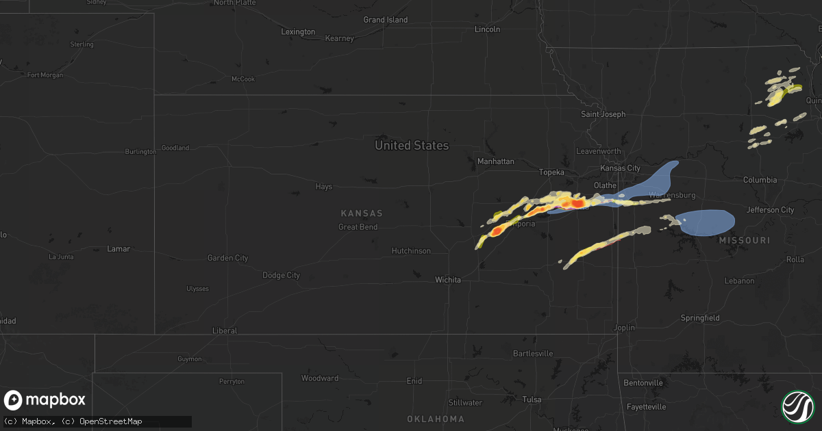
Hail Map in Kansas on April 13, 2026
Get this storm
April 13 map
$229
one time, instant access
Download today. No call, no setup
Keep the $229
Bought the map and want the full workflow? Apply the entire $229 to a subscription within 7 days. None of it is wasted.
Every map, not just this one
This buys you this map. Subscription and you get every map we run, in the markets you choose from a few cities to whole states to nationwide. Plus real-time alerts the moment a storm fires.
Contact data
Name, contact info, occupancy, even credit band for addresses in the footprint. You go from where it hit to who to call.
Become the source they trust
Unlimited branding weather history reports on demand. You already have the documented answer ready for the property owner, and you are the one who showed up with it.
Property data and RoofTrace estimates
Pull up any address you have got, its value and the exact code rules for that jurisdiction, straight from One Click Code. Then RoofTrace estimates the squares, pitch, and roof value, priced the way you price.
Storm reports in Kansas
Kansas
| Date | Description |
|---|---|
| 04/13/20266:35 PM CDT | A local report indicates 1.25 inch wind near Lyndon |
| 04/13/20266:32 PM CDT | A local report indicates 1.25 inch wind near 1 S Lyndon |
| 04/13/20266:30 PM CDT | A local report indicates 2.00 inch wind near 5 S Osage City |
| 04/13/20266:30 PM CDT | A local report indicates 2.00 inch wind near 5 S Osage City |
| 04/13/20266:05 PM CDT | Report from mping: hen egg |
| 04/13/20265:58 PM CDT | A local report indicates 1.75 inch wind near 4 W Reading |
| 04/13/20265:58 PM CDT | A local report indicates 1.25 inch wind near 4 W Reading |
| 04/13/20265:32 PM CDT | Emporia city manager reported quarter to half dollar size hail. |
| 04/13/20265:29 PM CDT | A local report indicates 1.00 inch wind near 4 SSE Americus |
| 04/13/20265:20 PM CDT | A local report indicates 1.00 inch wind near 3 NNE Saffordville |
| 04/13/20265:00 PM CDT | Corrects previous hail report from 6 n matfield green. Relayed via social media with picture. |
| 04/13/20265:00 PM CDT | Relayed via social media with picture. |
| 04/13/20265:00 PM CDT | Reported via ksn-tv and law enforcement. |
| 04/13/20264:55 PM CDT | A local report indicates 2.75 inch wind near 4 S Cottonwood Falls |
| 04/12/20269:38 PM CDT | Private weather sensor. |
| 04/12/20268:58 PM CDT | Downed tree limbs and wires near 263rd street. Time confirmed from radar. |
| 04/12/20268:44 PM CDT | Measured from mounted vehicle anemometer. Social media reports confirm damage in the area... With multiple trees downed... Roof damage to a property... And fence damage |
| 04/12/20268:42 PM CDT | Downed tree limbs and wires near 206th street. Time estimated from radar. |
| 04/12/20268:41 PM CDT | Downed trees and wires near rockville road. Time estimated from radar. |
| 04/12/20268:37 PM CDT | Private weather sensor. |
| 04/12/20268:36 PM CDT | Several social media reports of wind damage from the 215th and pflumm area... With multiple downed trees and minor property damage. Time estimated from radar. |
| 04/12/20268:36 PM CDT | Several reports of downed wires... Tree limbs... And power poles east of spring hill. Time estimated from radar. |
| 04/12/20268:36 PM CDT | Social media report of uprooted trees and several tree limbs down north of louisburg. Time estimated from radar. |
| 04/12/20268:33 PM CDT | Social media report of several trees downed east of webster and south of 215th. Time estimated from radar. |
| 04/12/20268:33 PM CDT | Social media report of severe damage to a chicken coop. Multiple trees down at the property as well. Time estimated from radar. |
| 04/12/20268:30 PM CDT | Multiple trees and fence posts downed as well as property damage to multiple residences near main street. Time estimated from radar. |
| 04/12/20268:30 PM CDT | Social media report of a damaged outbuilding and fence at a residence as well as multiple trees downed. Time estimated from radar. |
| 04/12/20268:30 PM CDT | Spotter reported a tornado crossing the road just south of pleasanton. |
| 04/12/20268:29 PM CDT | Downed tree limbs and wires near route 52. Possible tornado damage. Time confirmed from radar. |
| 04/12/20268:27 PM CDT | Several trees down with property damage near south street. Time estimated from radar. |
| 04/12/20268:27 PM CDT | Downed tree limbs and wires near foster street. Time estimated from radar. |
| 04/12/20268:24 PM CDT | Downed wires and power outages near 223rd street. Time estimated from radar. |
| 04/12/20268:23 PM CDT | Downed wires and power outages near clare road. Time estimated from radar. |
| 04/12/20268:22 PM CDT | Downed wires near 207th street. Time estimated from radar. |
| 04/12/20268:20 PM CDT | Damage in spring hill reported by em. Several trees and power poles down. Time estimated by radar. |
| 04/12/20268:20 PM CDT | *** 1 inj *** shortly before 820 pm cdt on monday april 13th... 2026... A supercell thunderstorm... That had previously resulted in an ef- 2 tornado in ottawa... Ks... |
| 04/12/20268:19 PM CDT | *** 2 inj *** corrects previous tornado report from 2 se mound city. Around 8 pm on 13 april 2026... An ef-1 tornado associated with a supercell developed in far southw |
| 04/12/20268:18 PM CDT | Downed wires near farm lane. Time estimated from radar. |
| 04/12/20268:18 PM CDT | Photo shared of a tornado on the ground... Looking northwest at the storm by a spotter. |
| 04/12/20268:16 PM CDT | Social media photo shows a tornado on the ground... Location is approximately sw of spring hill. |
| 04/12/20268:09 PM CDT | A brief tornado was observed via videos taken by a drone and storm spotters north of the much longer track tornado. Location was estimated via video evidence and radar |
| 04/12/20268:09 PM CDT | Reported roping out tornado as storm passed through blue mound. |
| 04/12/20268:08 PM CDT | Downed trees and wires near route 31. Possible tornado damage. Time estimated from radar. |
| 04/12/20268:02 PM CDT | Downed wires near 350th road. Time estimated from radar. |
| 04/12/20267:49 PM CDT | Downed wires near waverly road. Time estimated from radar. |
| 04/12/20267:42 PM CDT | A local report indicates 2.75 inch wind near 1 N Ottawa |
| 04/12/20267:38 PM CDT | Observed moving east. |
| 04/12/20267:35 PM CDT | Damage to the roof and a wall of the t-mobile store on south main street in ottawa. |
| 04/12/20267:35 PM CDT | Reports of damage in southern ottawa... On main street between 15th and 23rd... Including wall and rood damage to a hotel... Roof damage and wall down at a gas station. |
| 04/12/20267:30 PM CDT | Delayed report of 2 inch hail stones across the street from ottawa high school. Photos sent via email. |
| 04/12/20267:15 PM CDT | Spotter confirmed he was seeing debris but is about 15 miles south so can not fully see the actual tornado. |
| 04/12/20267:10 PM CDT | Hail was observed on the ground behind the storm. |
| 04/12/20267:07 PM CDT | Delayed report. Storm chaser reported a tornado occurred just southwest of town. Was on the ground approximately two minutes and damaged a sheet metal shed. |
All States Impacted by Hail Map on April 13, 2026
Cities Impacted by Hail Map on April 13, 2026
- Hamilton, IL
- Nauvoo, IL
- Bradford, IL
- Wyoming, IL
- Henry, IL
- Sparland, IL
- Clinton, IA
- Bryant, IA
- Wenona, IL
- Putnam, IL
- Streator, IL
- Magnolia, IL
- Lacon, IL
- Hennepin, IL
- Sabula, IA
- McNabb, IL
- Granville, IL
- Sterling, IL
- Peru, IL
- Standard, IL
- Oglesby, IL
- Ottawa, IL
- Cabery, IL
- Dwight, IL
- Buckingham, IL
- Odell, IL
- Emington, IL
- Campus, IL
- Utica, IL
- Marseilles, IL
- Reddick, IL
- Herscher, IL
- Gardner, IL
- Union Hill, IL
- Bonfield, IL
- Essex, IL
- Wilmington, IL
- Kankakee, IL
- Chebanse, IL
- Martinton, IL
- Saint Anne, IL
- Papineau, IL
- Beaverville, IL
- Weston, WY
- Grant Park, IL
- Momence, IL
- Broadus, MT
- Hammond, MT
- Bourbonnais, IL
- Moorcroft, WY
- Hulett, WY
- Lowell, IN
- Alzada, MT
- Watseka, IL
- Donovan, IL
- Dryden, TX
- Hillpoint, WI
- Loganville, WI
- La Valle, WI
- Lime Ridge, WI
- Reedsburg, WI
- Morocco, IN
- Richland Center, WI
- Pembroke Township, IL
- Cazenovia, WI
- Faribault, MN
- Capitol, MT
- Northfield, MN
- Nerstrand, MN
- Fort Stockton, TX
- Ekalaka, MT
- Dennison, MN
- Rensselaer, IN
- Fair Oaks, IN
- Mount Ayr, IN
- Kenyon, MN
- Cannon Falls, MN
- Tripp, SD
- Olivet, SD
- Baraboo, WI
- Camp Crook, SD
- Goodhue, MN
- Portage, WI
- Burns, KS
- Menno, SD
- Freeman, SD
- Cedar Point, KS
- Anson, TX
- Red Wing, MN
- Welch, MN
- Stevens Point, WI
- Stockholm, WI
- Pepin, WI
- Buffalo, SD
- Midkiff, TX
- Sweetwater, TX
- Roby, TX
- Sylvester, TX
- McCaulley, TX
- Custer, WI
- Rosholt, WI
- Cottonwood Falls, KS
- Hatley, WI
- Howe, IN
- Plum City, WI
- Spencer, WI
- Loyal, WI
- Granton, WI
- Wittenberg, WI
- Eland, WI
- Sturgis, MI
- Neillsville, WI
- Marshfield, WI
- Big Lake, TX
- Maiden Rock, WI
- Nelson, WI
- Strong City, KS
- Durand, WI
- Marion, SD
- Constantine, MI
- Three Rivers, MI
- Emporia, KS
- Centreville, MI
- Mendon, MI
- Bowler, WI
- Burr Oak, MI
- Merrillan, WI
- Wisconsin Rapids, WI
- Pittsville, WI
- Stratford, WI
- Tigerton, WI
- Vesper, WI
- Hamlin, TX
- Haskell, TX
- Wheeler, WI
- Weinert, TX
- Chili, WI
- Garden City, TX
- Eleva, WI
- Strum, WI
- Kingsley, IA
- Moville, IA
- Cornell, WI
- Bronson, MI
- Birnamwood, WI
- Parker, SD
- Holcombe, WI
- Odin, MN
- Lake City, MN
- Humbird, WI
- Bloomer, WI
- Lonsdale, MN
- New Prague, MN
- Zumbrota, MN
- Montgomery, MN
- Kilkenny, MN
- Throckmorton, TX
- Americus, KS
- Arpin, WI
- Sterling City, TX
- Columbia City, IN
- Roanoke, IN
- Fort Wayne, IN
- Arcola, IN
- Gilman, WI
- Saint James, MN
- Butterfield, MN
- Ormsby, MN
- Union Center, SD
- Nicollet, MN
- Le Mars, IA
- Remsen, IA
- Hinton, IA
- Marathon, WI
- Mosinee, WI
- Mondovi, WI
- Rudolph, WI
- Fulda, MN
- Mankato, MN
- Boyd, WI
- Osseo, WI
- Frontenac, MN
- Marcus, IA
- Stamford, TX
- Reading, KS
- Saint Peter, MN
- Sheldon, WI
- Wausau, WI
- Lewisville, MN
- Ruthven, IA
- Dickens, IA
- Pierson, IA
- Le Center, MN
- Seymour, TX
- Heron Lake, MN
- Comfrey, MN
- Darfur, MN
- Estherville, IA
- Granville, IA
- Paullina, IA
- Avoca, TX
- Medford, WI
- Sioux Falls, SD
- Tea, SD
- Lennox, SD
- Kasota, MN
- Ossian, IN
- Yoder, IN
- Decatur, IN
- Hoagland, IN
- Monroeville, IN
- New Haven, IN
- Woodburn, IN
- Grabill, IN
- Wabasha, MN
- Reads Landing, MN
- Amboy, MN
- Truman, MN
- Vernon Center, MN
- Hanska, MN
- Sleepy Eye, MN
- Auburndale, WI
- Webster, MN
- Windom, MN
- Edgar, WI
- Plainwell, MI
- Armstrong, IA
- Schofield, WI
- Dundas, MN
- Plover, WI
- Osage City, KS
- Westboro, WI
- Archer, IA
- Graettinger, IA
- Cleveland, MN
- Amherst Junction, WI
- Amherst, WI
- Scandinavia, WI
- Nelsonville, WI
- Iola, WI
- Convoy, OH
- Antwerp, OH
- Payne, OH
- Paulding, OH
- Scott, OH
- Haviland, OH
- Cecil, OH
- Alma, WI
- Fall Creek, WI
- Kellogg, MN
- Westbrook, TX
- Melvin, IA
- Ocheyedan, IA
- Arkansaw, WI
- Delton, MI
- Council Grove, KS
- Dolliver, IA
- Emmetsburg, IA
- Valley Springs, SD
- Fountain City, WI
- Cochrane, WI
- Elmdale, KS
- Loraine, TX
- Colorado City, TX
- Lyndon, KS
- Sanborn, IA
- Primghar, IA
- Vassar, KS
- Hastings, MI
- Grover Hill, OH
- Cloverdale, OH
- Oakwood, OH
- Latty, OH
- Melrose, OH
- Defiance, OH
- Good Thunder, MN
- Madelia, MN
- Roscoe, TX
- Whitehall, WI
- Altura, MN
- Morristown, MN
- Waseca, MN
- Brandon, SD
- Chancellor, SD
- Admire, KS
- Cleghorn, IA
- Bingham Lake, MN
- Mountain Lake, MN
- Augusta, WI
- Janesville, MN
- Allen, KS
- Beaver Creek, MN
- Milladore, WI
- Madison Lake, MN
- Lake Park, IA
- Harris, IA
- Arcadia, WI
- Hartford, SD
- Fairchild, WI
- Cherokee, IA
- Meriden, IA
- Spencer, IA
- Royal, IA
- Fairmont, MN
- Wallingford, IA
- Ceylon, MN
- Lebo, KS
- Melvern, KS
- Lake Crystal, MN
- Quenemo, KS
- Waterville, MN
- Elysian, MN
- Ashton, IA
- Sibley, IA
- Medford, MN
- Owatonna, MN
- Alma Center, WI
- Marion, WI
- Manawa, WI
- Ogdensburg, WI
- Hartley, IA
- Junction City, WI
- Larrabee, IA
- Independence, WI
- Peterson, IA
- Athens, WI
- Mapleton, MN
- Swea City, IA
- Granada, MN
- Humboldt, KS
- Ringsted, IA
- Springfield, MN
- Terril, IA
- Milford, IA
- Luverne, MN
- Eskridge, KS
- Piqua, KS
- Bear Creek, WI
- Clintonville, WI
- Continental, OH
- Freeport, MI
- Woodland, MI
- Lake Odessa, MI
- Vermontville, MI
- Hermleigh, TX
- Stanley, WI
- Willard, WI
- Garden City, MN
- New London, WI
- Spalding, NE
- New Ulm, MN
- Spirit Lake, IA
- Arnolds Park, IA
- Winnebago, MN
- Hixton, WI
- Scranton, KS
- Burlingame, KS
- Magnolia, MN
- Iola, KS
- Elmore, MN
- Blue Earth, MN
- Pomona, KS
- Sutherland, IA
- Embarrass, WI
- Aurelia, IA
- Linn Grove, IA
- Overbrook, KS
- Everly, IA
- Sunfield, MI
- Portland, MI
- Ottawa, KS
- Minnesota Lake, MN
- Shiocton, WI
- Blair, WI
- Ettrick, WI
- Ledyard, IA
- Rushmore, MN
- Rotan, TX
- Adrian, MN
- Merrill, WI
- La Harpe, KS
- Moran, KS
- Wanamingo, MN
- Primrose, NE
- Oregon, OH
- Carbondale, KS
- McComb, OH
- Lismore, MN
- Wilmont, MN
- Westphalia, MI
- Pewamo, MI
- Williamsburg, KS
- Waldorf, MN
- Green Bay, WI
- Kincaid, KS
- Blue Mound, KS
- Claremont, MN
- West Concord, MN
- Reading, MN
- Burt, IA
- Lone Rock, IA
- Taylor, WI
- Webb, IA
- Sioux Rapids, IA
- Greenville, IA
- De Pere, WI
- Buffalo Center, IA
- Mazeppa, MN
- Oneida, WI
- Bonduel, WI
- Black Creek, WI
- Baldwin City, KS
- Curtice, OH
- Greenwood, WI
- Bancroft, IA
- Fenton, IA
- Bronson, KS
- Galesville, WI
- Seymour, WI
- Caroline, WI
- Leopolis, WI
- Pemberton, MN
- Worthington, MN
- Brewster, MN
- Melrose, WI
- Black River Falls, WI
- Lawrence, KS
- Saint Johns, MI
- Fowler, MI
- Pulaski, WI
- Hewitt, WI
- New Franken, WI
- Millbury, OH
- Frost, MN
- Bricelyn, MN
- Rake, IA
- Thompson, IA
- Ayrshire, IA
- Gillett Grove, IA
- Titonka, IA
- Aspermont, TX
- Eagle, MI
- Grand Ledge, MI
- Wellsville, KS
- Trimont, MN
- Lyons, MI
- Luxemburg, WI
- Round Lake, MN
- Hospers, IA
- Dodge Center, MN
- Shawano, WI
- Toledo, OH
- Rantoul, KS
- Paola, KS
- Edgerton, KS
- Wells, MN
- Kiester, MN
- Eagle Lake, MN
- Millville, MN
- Mound City, KS
- Okabena, MN
- Curlew, IA
- Spring Hill, KS
- Laurens, IA
- Delavan, MN
- Zumbro Falls, MN
- Warsaw, MN
- Scarville, IA
- Lakefield, MN
- Emmons, MN
- Alden, MN
- Louisburg, KS
- Bucyrus, KS
- Sparta, WI
- Pine Island, MN
- Gardner, KS
- Pleasanton, KS
- Suamico, WI
- Twin Lakes, MN
- Hayward, MN
- Glenville, MN
- Northwood, IA
- Albert Lea, MN
- Lake Mills, IA
- Conger, MN
- Eudora, KS
- Hollandale, MN
- Austin, MN
- Old Glory, TX
- Cleveland, MO
- Stilwell, KS
- Lyle, MN
- Saint Ansgar, IA
- Foster, MO
- Tomah, WI
- Warrens, WI
- Bangor, WI
- Mindoro, WI
- Oakley, MI
- Chesaning, MI
- Mantorville, MN
- Amoret, MO
- Belton, MO
- Jackson, MN
- Lansing, MN
- Waltham, MN
- Rose Creek, MN
- Brownsdale, MN
- Peculiar, MO
- Freeman, MO
- Butler, MO
- Raymore, MO
- Pleasant Hill, MO
- Kansas City, MO
- Grandview, MO
- Lees Summit, MO
- Greenwood, MO
- Hayfield, MN
- Blooming Prairie, MN
- Kasson, MN
- Sargeant, MN
- Byron, MN
- Dexter, MN
- Elkton, MN
- Adams, MN
- Grand Meadow, MN
- Stewartville, MN
- Saint Charles, MI
- Montrose, MI
- Joice, IA
- Woden, IA
- Burt, MI
- Birch Run, MI
- Saginaw, MI
- Bridgeport, MI
- Alpha, MN
- Kingsville, MO
- Strasburg, MO
- Lone Jack, MO
- Wesley, IA
- Nekoosa, WI
- Port Edwards, WI
- Nichols, WI
- Minnesota City, MN
- Forest City, IA
- Britt, IA
- Warrensburg, MO
- Holden, MO
- Centerview, MO
- Bates City, MO
- Odessa, MO
- Oak Grove, MO
- Mayview, MO
- Higginsville, MO
- Wellington, MO
- Lexington, MO
- Grain Valley, MO
- Garner, IA
- Denmark, WI
- Greenleaf, WI
- Camp Douglas, WI
- Winona, MN
- Bancroft, WI
- Plainfield, WI
- Kewaunee, WI
- Necedah, WI
- Trempealeau, WI
- Norwalk, WI
- Friendship, WI
- Almond, WI
- Caro, MI
- Vassar, MI
- Reese, MI
- Fairgrove, MI
- Waupaca, WI
- Leland, IA
- Crystal Lake, IA
- Ventura, IA
- Fertile, IA
- Clear Lake, IA
- Weyauwega, WI
- Holmen, WI
- Cass City, MI
- Standish, MI
- Bentley, MI
- Urich, MO
- Blairstown, MO
- Clinton, MO
- Chilhowee, MO
- Arkdale, WI
- Waverly, MO
- Alma, MO
- Concordia, MO
- Corder, MO
- Malta Bend, MO
- Blackburn, MO
- Carrollton, MO
- Sweet Springs, MO
- Miami, MO
- Knob Noster, MO
- Marshall, MO
- Calhoun, MO
- Windsor, MO
- Harrisonville, MO
- Omer, MI
- Au Gres, MI
- Hancock, WI
- Mason City, IA
- Lanesboro, MN
- Sterling, MI
- Lincoln, MO
- Warsaw, MO
- Walkerville, MI
- Hart, MI
- Twining, MI
- Turner, MI
- Ludington, MI
- Whittemore, MI
- East Lynne, MO
- Wautoma, WI
- Free Soil, MI
- Manistee, MI
- Scottville, MI
- Garden City, MO
- National City, MI
- Tawas City, MI
- New Lisbon, WI
- Branch, MI
- Bitely, MI
- Cole Camp, MO
- Baldwin, MI
- Idlewild, MI
- Charles City, IA
- Ripon, WI
- Pickett, WI
- Edwards, MO
- Stover, MO
- Gravois Mills, MO
- Versailles, MO
- Eldorado, WI
- Oshkosh, WI
- McIntire, IA
- Riceville, IA
- Manitowoc, WI
- Reedsville, WI
- Chase, MI
- Reed City, MI
- Colwell, IA
- Ionia, IA
- Alta Vista, IA
- Luther, MI
- Leroy, MI
- Tustin, MI
- Glenbeulah, WI
- Plymouth, WI
- Wellston, MI
- Le Roy, MN
- Chester, IA
- Marion, MI
- McBain, MI
- Cadillac, MI
- Sheboygan Falls, WI
- Boon, MI
- Harrietta, MI
- Ionia, MI
- Cambria, WI
- Markesan, WI
- Randolph, WI
- Muir, MI
- Mesick, MI
- Orleans, MI
- Fenwick, MI
- Waupun, WI
- Brandon, WI
- Stoughton, WI
- Rosendale, WI
- Taopi, MN
- Fox Lake, WI
- Oakfield, WI
- Irons, MI
- Harrison, MI
- Gladwin, MI
- Brant, MI
- Fountain, MI
- Ashley, MI
- Coon Valley, WI
- Higbee, MO
- Huntsville, MO
- Lannon, WI
- Menomonee Falls, WI
- Sussex, WI
- Moberly, MO
- Madison, MO
- Jacksonville, MO
- Cairo, MO
- Bay City, MI
- Munger, MI
- Essexville, MI
- Waukesha, WI
- Pewaukee, WI
- Brookfield, WI
- Elm Grove, WI
- Milwaukee, WI
- Akron, MI
- Unionville, MI
- Atlanta, MO
- Sebewaing, MI
- Clarence, MO
- Excello, MO
- Leonard, MO
- Owendale, MI
- Gagetown, MI
- Shelbina, MO
- Bethel, MO
- Novelty, MO
- Shelbyville, MO
- Edina, MO
- Rutledge, MO
- Hurdland, MO
- Newark, MO
- Knox City, MO
- Hunnewell, MO
- Paris, MO
- Lewistown, MO
- La Belle, MO
- Palmyra, MO
- Monroe City, MO
- Ewing, MO
- Wyaconda, MO
- Kahoka, MO
- Williamstown, MO
- Saint Patrick, MO
- Monticello, MO
- Quincy, IL
- Barnett, MO
- Camp Point, IL
- Fowler, IL
- Orion, IL
- Osco, IL
- Rothschild, WI
- Geneseo, IL
- Atkinson, IL
- Ostrander, MN
- Spring Valley, MN
- Racine, MN
- Oconomowoc, WI
- Hartland, WI
- Nashotah, WI
- Okauchee, WI
- Sullivan, WI
- Jefferson, WI
- Delafield, WI
- Watertown, WI
- Helenville, WI
- Johnson Creek, WI
- Fort Atkinson, WI
- Dousman, WI
- Palmyra, WI
- Wales, WI
- Eagle, WI
- North Prairie, WI
- Mukwonago, WI
- New Berlin, WI
- Butler, WI
- Mendota, IL
- Troy Grove, IL
- Kewanee, IL
- Toulon, IL
- Neponset, IL
- Morris, IL
- Tonica, IL
- Lostant, IL
- Waunakee, WI
- Middleton, WI
- Cross Plains, WI
- Green Ridge, MO
- Sedalia, MO
- Ionia, MO
- Mora, MO
- Smithton, MO
- Fortuna, MO
- Florence, MO
- Lake Mills, WI
- Cambridge, WI
- Waterloo, WI
- Cottage Grove, WI
- Deerfield, WI
- Marshall, WI
- Sun Prairie, WI
- Madison, WI
- Deforest, WI
- Windsor, WI
- Arlington, WI
- Lodi, WI
- Dane, WI
- Morrisonville, WI
- Columbus, WI
- Rio, WI
- Poynette, WI
- Merrimac, WI
- North Freedom, WI
- Pardeeville, WI
- Ubly, MI
- Bad Axe, MI
- Rock Springs, WI
- Wisconsin Dells, WI
- Wyocena, WI
- Doylestown, WI
- Fall River, WI
- Juneau, WI
- Burnett, WI
- Beaver Dam, WI
- Lowell, WI
- Reeseville, WI
- Iron Ridge, WI
- Horicon, WI
- Allenton, WI
- Rubicon, WI
- Mayville, WI
- Neosho, WI
- Clyman, WI
- Hustisford, WI
- Hartford, WI
- Lebanon, WI
- Jackson, WI
- Slinger, WI
- Richfield, WI
- West Bend, WI
- Ixonia, WI
- Ashippun, WI
- Germantown, WI
- Mequon, WI
- Cedarburg, WI
- Colgate, WI
- Hubertus, WI
- Friesland, WI
- Theresa, WI
- Lomira, WI
- Brownsville, WI
- Campbellsport, WI
- Kewaskum, WI
- Fredonia, WI
- Random Lake, WI
- Cedar Grove, WI
- Port Washington, WI
- Grafton, WI
- Belgium, WI
- Saukville, WI
- Prairie Du Sac, WI
- Sauk City, WI
- Mazomanie, WI
- Oregon, WI
- Mcfarland, WI
- Edgerton, WI
- Whitewater, WI
- East Troy, WI
- Elkhorn, WI
- Burlington, WI
- Waterford, WI
- Big Bend, WI
- Salem, WI
- Kansasville, WI
- Rochester, WI
- Kenosha, WI
- Muskego, WI
- Union Grove, WI
- Bristol, WI
- Sturtevant, WI
- Franksville, WI
- Pleasant Prairie, WI
- Caledonia, WI
- Franklin, WI
- Racine, WI
- Oak Creek, WI
- Greendale, WI
- Hales Corners, WI
- South Milwaukee, WI
- Cudahy, WI
- Saint Francis, WI
- Plain, WI
- Olathe, KS
- Overland Park, KS
- Dover, MO
- Dodgeville, WI
- Blue River, WI
- Hollandale, WI
- Mineral Point, WI
- Avoca, WI
- Muscoda, WI
- Cobb, WI
- Highland, WI
- Boscobel, WI
- Brook, IN
- Union Mills, IN
- Wanatah, IN
- Westville, IN
- Hanna, IN
- Valparaiso, IN
- Fond Du Lac, WI
- Kenneth, MN
- Coldwater, MI
- New Richland, MN


