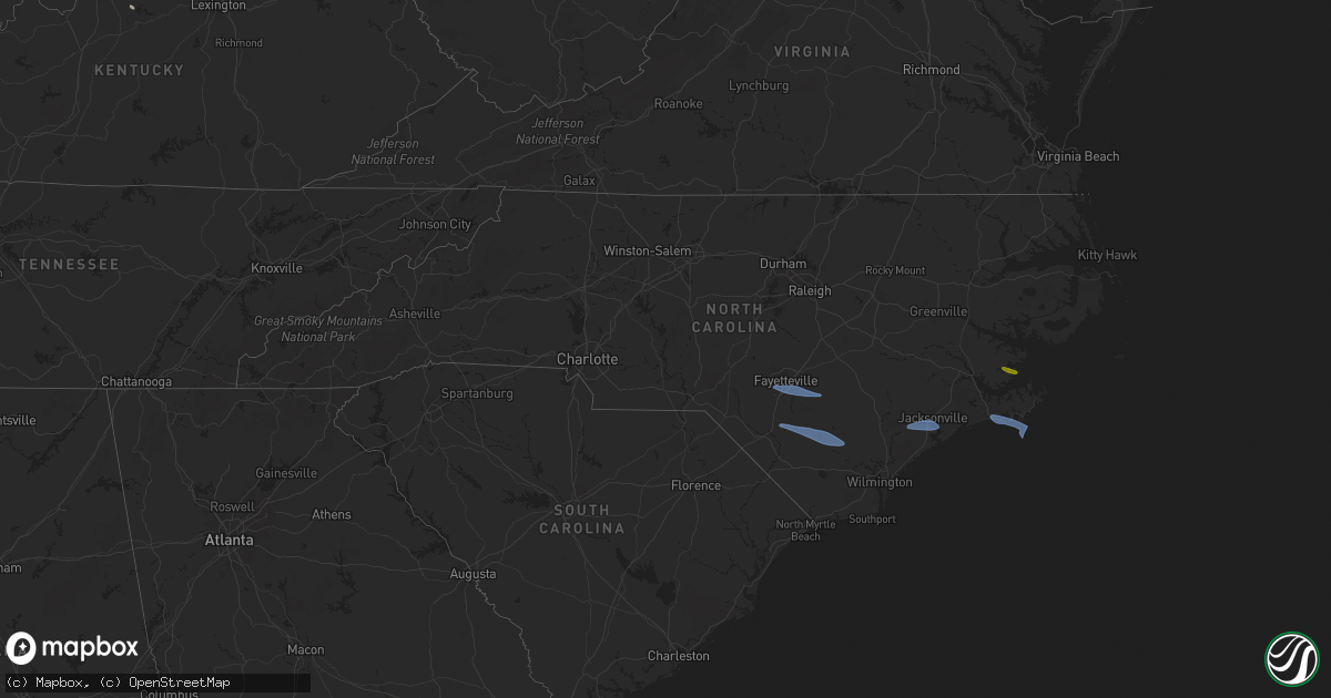
Hail Map in North Carolina on April 12, 2024
Get this storm
April 12 map
$229
one time, instant access
Download today. No call, no setup
Keep the $229
Bought the map and want the full workflow? Apply the entire $229 to a subscription within 7 days. None of it is wasted.
Every map, not just this one
This buys you this map. Subscription and you get every map we run, in the markets you choose from a few cities to whole states to nationwide. Plus real-time alerts the moment a storm fires.
Contact data
Name, contact info, occupancy, even credit band for addresses in the footprint. You go from where it hit to who to call.
Become the source they trust
Unlimited branding weather history reports on demand. You already have the documented answer ready for the property owner, and you are the one who showed up with it.
Property data and RoofTrace estimates
Pull up any address you have got, its value and the exact code rules for that jurisdiction, straight from One Click Code. Then RoofTrace estimates the squares, pitch, and roof value, priced the way you price.
Storm reports in North Carolina
North Carolina
| Date | Description |
|---|---|
| 04/12/20246:53 PM CDT | Power line damage reported in warsaw. |
| 04/12/20246:30 PM CDT | Trees reported down in lenoir county. Time estimated based on radar. |
| 04/12/20246:15 PM CDT | Large tree down and nc 41 closed |
| 04/12/20246:15 PM CDT | Report from mping: trees uprooted or snapped. |
| 04/12/20246:15 PM CDT | Report from mping: trees |
| 04/12/20246:12 PM CDT | A few trees were reported down in the turkey area between turkey highway and old warsaw rd. Time estimated. |
| 04/12/20246:10 PM CDT | A local report indicates 61 MPH wind near Elizabethtown Arpt |
| 04/12/20246:05 PM CDT | Large tree down |
| 04/12/20245:52 PM CDT | Half dozen trees down and powerlines as well. |
| 04/12/20245:47 PM CDT | Multiple trees were reported down in the salemburg area... Especially along salemburg highway. Time estimated. |
| 04/12/20245:45 PM CDT | Reports of multiple large trees and power lines down. |
| 04/12/20245:41 PM CDT | Multiple trees were reported down in the autryville area... Especially along yellow skin rd. Time estimated. |
| 04/12/20245:28 PM CDT | Pk wnd 28051/2228. |
| 04/12/20245:28 PM CDT | Trees were reported down along doc bennett rd. Time estimated. |
| 04/12/20245:20 PM CDT | Trees down along crystal springs rd. Time estimated. |
| 04/12/20245:15 PM CDT | A tree was blown down near the intersection of arabia rd. And mcgougan rd. Time estimated. |
| 04/12/20245:14 PM CDT | A tree was blown down on n. Old wire rd. Time estimated. |
| 04/12/20245:12 PM CDT | Trees were blown down near the intersection of walter gibson rd. And blue springs rd. In red springs. Time estimated. |
| 04/12/20245:04 PM CDT | Corrects previous tstm wnd dmg report time from 5 s wagram. Report from mping: trees uprooted or snapped. |
| 04/12/20245:04 PM CDT | A tree was blown down onto the 500 block of e. Edinborough ave. In raeford. Time estimated. |
| 04/12/20245:00 PM CDT | Trees were blown down along old wire road. Numerous other trees and powerlines were reported down across the county... Including along turnpike rd. And aberdeen rd. Tim |
| 04/12/20245:00 PM CDT | A tree was blown down on the 300 block of n fulton st. In raeford. Time estimated. |
| 04/12/20244:46 PM CDT | A tree was blown down onto powerlines along george dawkins rd. North of n nc highway 177. Time estimated. Numerous other trees were reported down in hamlet... Including |
| 04/12/20244:46 PM CDT | A tree was blown down onto a residence along hide away ln. In hamlet. Time estimated. |
| 04/12/20244:41 PM CDT | Multiple trees were blown down in the area of safie 3rd st. And safie 4th st. In east rockingham. Time estimated. |
| 04/12/20244:37 PM CDT | Trees and powerlines were reported down along s. And n. Randolph st.... N. Lee st.... And rockingham rd. In rockingham. Time estimated. |
| 04/11/20247:58 PM CDT | Kmrh reported a gust of 51 knots. |
| 04/11/20247:56 PM CDT | Fort macon wxflow reported gust of 50 kts. |
| 04/11/20247:28 PM CDT | Social media report of heavy damage to chicken coop. |
| 04/11/20247:18 PM CDT | 55 kt gust reported at knca asos. |
| 04/11/20247:17 PM CDT | Numerous power outages reported by duke energy in the half moon area north of jacksonville. |
| 04/11/20247:08 PM CDT | Report from mping: 3-inch tree limbs broken; power poles broken. |
| 04/11/20247:05 PM CDT | Tree down on power lines along bannermans mill rd in richlands. |
| 04/11/20247:04 PM CDT | Social media report of tree falling on road... Covering two lanes and the median. Branches hit cars and went through windshields. Richlands hwy & fox creek dr. |
All States Impacted by Hail Map on April 12, 2024
Cities Impacted by Hail Map on April 12, 2024
- Prairie City, OR
- Lovelock, NV
- Fallon, NV
- Taylorsville, KY
- Fayetteville, NC
- Hope Mills, NC
- Stedman, NC
- Autryville, NC
- Roseboro, NC
- Falmouth, KY
- Lumberton, NC
- Bladenboro, NC
- Elizabethtown, NC
- Tar Heel, NC
- Clarkton, NC
- Council, NC
- Kelly, NC
- Ivanhoe, NC
- Jacksonville, NC
- Maple Hill, NC
- Camp Lejeune, NC
- Merritt, NC
- Bayboro, NC
- Oriental, NC
- Newport, NC
- Morehead City, NC
- Atlantic Beach, NC
- Beaufort, NC
- Harkers Island, NC
- Maysville, KY
- Springdale, MT
- Big Timber, MT
- McLeod, MT
- Livingston, MT


