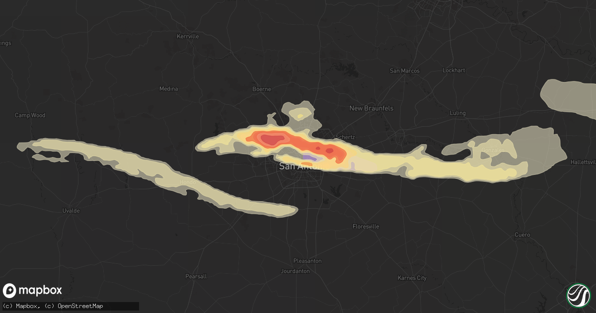
Hail Map in San Antonio, TX on April 12, 2016
Get this storm
April 12 map
$229
one time, instant access
Download today. No call, no setup
Keep the $229
Bought the map and want the full workflow? Apply the entire $229 to a subscription within 7 days. None of it is wasted.
Every map, not just this one
This buys you this map. Subscription and you get every map we run, in the markets you choose from a few cities to whole states to nationwide. Plus real-time alerts the moment a storm fires.
Contact data
Name, contact info, occupancy, even credit band for addresses in the footprint. You go from where it hit to who to call.
Become the source they trust
Unlimited branding weather history reports on demand. You already have the documented answer ready for the property owner, and you are the one who showed up with it.
Property data and RoofTrace estimates
Pull up any address you have got, its value and the exact code rules for that jurisdiction, straight from One Click Code. Then RoofTrace estimates the squares, pitch, and roof value, priced the way you price.
Storm reports in San Antonio, TX
San Antonio, TX
| Date | Description |
|---|---|
| 04/11/201610:14 PM CDT | Golfball hail or slightly larger with 1.34 inches of rain in 10 minutes |
| 04/11/201610:00 PM CDT | A local report indicates 2.75 inch wind near 1 NE TERRELL HILLS |
| 04/11/20169:55 PM CDT | 2.5 inch hail reported near shamrock and wheatland in kirby |
| 04/11/20169:48 PM CDT | 3 inch diameter hail reported at the intersection of austin highway and north new braunfels road in the alamo heights area. |
| 04/11/20169:46 PM CDT | Got a delayed hail report with a picture on facebook. Ruler showing hail measured 4 inches. Time estimated via radar. |
| 04/11/20169:43 PM CDT | 1.5 inch hail reported near jackson keller and shalimar by a trained spotter |
| 04/11/20169:42 PM CDT | Teacup size hail reported near n new braunfels and eisenhauer |
| 04/11/20169:40 PM CDT | A local report indicates 62 MPH wind near SAN ANTONIO INT AP |
| 04/11/20169:40 PM CDT | A local report indicates 2.00 inch wind near SAN ANTONIO INT AP |
| 04/11/20169:39 PM CDT | Twitter report of 3.5 inch hail measured at bandera rd and huebner road north of san antonio. |
| 04/11/20169:35 PM CDT | Three inch diameter hail reported on the campus of the university of the incarnate word. |
| 04/11/20169:31 PM CDT | 1.5 inch hail leaving dents in cars |
| 04/11/20169:29 PM CDT | 2 inch hail measured near bandera rd and guilbeau rd |
| 04/11/20169:28 PM CDT | 1 inch hail near de zavala and vance jackson intersection |
| 04/11/20169:26 PM CDT | A local report indicates 2.00 inch wind near 3 S FIESTA TEXAS |
| 04/11/20169:24 PM CDT | Hail reported on pioneer gold road near helotes. Between golf ball and tennis ball sized via trained spotter. |
| 04/11/20169:20 PM CDT | Photo received of hail near tezel rd and bandera rd measuring 4.5 in diameter...softball sized. |
| 04/11/20169:18 PM CDT | Golf ball sized hail reported near talley road and culebra road in western bexar county. |
| 04/11/20169:18 PM CDT | Delayed hail report received on facebook with picture of measured 4 inch hail in the bandera rd and 1604 area. Time estimated via radar. |
All States Impacted by Hail Map on April 12, 2016
All Cities Impacted by Hail Map on April 12, 2016
- Beasley, TX
- Danbury, TX
- Brookshire, TX
- Rosenberg, TX
- Galveston, TX
- Wharton, TX
- South Houston, TX
- Houston, TX
- Liverpool, TX
- La Marque, TX
- Richmond, TX
- Freeport, TX
- Kemah, TX
- Boling, TX
- Guy, TX
- Bacliff, TX
- Friendswood, TX
- Seabrook, TX
- West Columbia, TX
- East Bernard, TX
- Katy, TX
- Baytown, TX
- League City, TX
- El Campo, TX
- Wallis, TX
- Angleton, TX
- Webster, TX
- Santa Fe, TX
- Needville, TX
- Damon, TX
- Hitchcock, TX
- Rosharon, TX
- Texas City, TX
- Pearland, TX
- Pasadena, TX
- Fulshear, TX
- Deer Park, TX
- Sealy, TX
- Alvin, TX
- Manvel, TX
- Sugar Land, TX
- Dickinson, TX
- Cotulla, TX
- Liberty, SC
- Labadieville, LA
- Thibodaux, LA
- Napoleonville, LA
- Rocksprings, TX
- Asherton, TX
- Lake Jackson, TX
- Clute, TX
- Kaplan, LA
- Gueydan, LA
- Kyle, TX
- San Marcos, TX
- Mico, TX
- Pipe Creek, TX
- Bandera, TX
- Shiner, TX
- San Antonio, TX
- Bell City, LA
- Lacassine, LA
- Lake Arthur, LA
- Brackettville, TX
- Uvalde, TX
- Helotes, TX
- Big Wells, TX
- Midkiff, TX
- Del Rio, TX
- Comstock, TX
- Lytle, TX
- Natalia, TX
- Devine, TX
- Utopia, TX
- Hondo, TX
- Des Allemands, LA
- Medina, TX
- Tarpley, TX
- Quemado, TX
- Eagle Pass, TX
- Carrizo Springs, TX
- Catarina, TX
- La Grange, TX
- Muldoon, TX
- Flatonia, TX
- Weimar, TX
- Schulenburg, TX
- Saint Hedwig, TX
- La Vernia, TX
- Marion, TX
- Seguin, TX
- Gonzales, TX
- D Hanis, TX
- Cost, TX
- Nixon, TX
- Leesville, TX
- Williamston, SC
- Pendleton, SC
- Anderson, SC
- Belton, SC
- Abbeville, LA
- Port Bolivar, TX
- Glidden, TX
- Columbus, TX
- Cat Spring, TX
- Alleyton, TX
- Moulton, TX
- Kendalia, TX
- Boerne, TX
- Crystal City, TX
- Converse, TX
- Jbsa Ft Sam Houston, TX
- Schertz, TX
- Adkins, TX
- Barnhart, TX
- Big Lake, TX
- Morgan City, LA
- Bay City, TX
- Louise, TX
- Markham, TX
- Van Vleck, TX
- San Angelo, TX
- Edna, TX
- Bloomington, TX
- Sweeny, TX
- Pierre Part, LA
- Duson, LA
- Rayne, LA
- Somerset, TX
- Atascosa, TX
- Sabinal, TX
- Von Ormy, TX
- Concan, TX
- Broussard, LA
- Lolita, TX
- Universal City, TX
- Wrightsboro, TX
- Jbsa Randolph, TX
- Smiley, TX
- Stockdale, TX
- Jeanerette, LA
- Fischer, TX
- Wimberley, TX
- Port Lavaca, TX
- Lake Charles, LA
- Cibolo, TX
- Dale, TX
- Red Rock, TX
- Lockhart, TX
- Pickens, SC
- Mertzon, TX
- Rio Medina, TX
- Cameron, LA
- Iowa, LA
- Brazoria, TX
- Jennings, LA
- Hackberry, LA
- Baldwin, LA
- Franklin, LA
- Mountain Home, TX
- Hunt, TX
- Leakey, TX
- Rosanky, TX
- Blanco, TX
- Easley, SC
- Castroville, TX
- Junction, TX
- Spring Branch, TX
- Missouri City, TX
- Fresno, TX
- Ozona, TX
- Beaumont, TX
- Vidor, TX
- Waelder, TX
- Hallettsville, TX
- Raceland, LA
- Vacherie, LA
- Nederland, TX
- Anahuac, TX
- Mason, TX
- Maurice, LA
- Eagle Lake, TX
- Garwood, TX
- Galena Park, TX
- Glen Flora, TX
- Channelview, TX
- La Porte, TX
- Fredericksburg, TX
- Yorktown, TX
- Meyersville, TX
- Maxwell, TX
- Palacios, TX
- Lafitte, LA
- Marrero, LA
- Barataria, LA
- Harper, TX
- La Coste, TX


