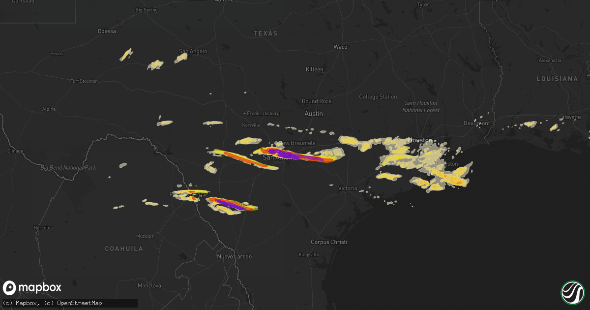
Hail Map on April 12, 2016
Get this storm
April 12 map
$229
one time, instant access
Download today. No call, no setup
Keep the $229
Bought the map and want the full workflow? Apply the entire $229 to a subscription within 7 days. None of it is wasted.
Every map, not just this one
This buys you this map. Subscription and you get every map we run, in the markets you choose from a few cities to whole states to nationwide. Plus real-time alerts the moment a storm fires.
Contact data
Name, contact info, occupancy, even credit band for addresses in the footprint. You go from where it hit to who to call.
Become the source they trust
Unlimited branding weather history reports on demand. You already have the documented answer ready for the property owner, and you are the one who showed up with it.
Property data and RoofTrace estimates
Pull up any address you have got, its value and the exact code rules for that jurisdiction, straight from One Click Code. Then RoofTrace estimates the squares, pitch, and roof value, priced the way you price.
States Impacted by Hail Map on April 12, 2016
Storm reports
Louisiana
| Date | Description |
|---|---|
| 04/12/20168:48 AM CDT | Numerous jagged stones near quarter size. Relayed by emergency management. |
| 04/12/20166:15 AM CDT | Public picture via social media reported ping pong ball sized hail in chackbay. |
| 04/12/20166:10 AM CDT | Public picture via twitter revealed golfball size hail. |
Texas
| Date | Description |
|---|---|
| 04/12/20162:35 AM CDT | Minor wind damge along wolfglen estates drive. Utility pole blown down. Evidence of lots of hail with area covered with green tree leaves. |
| 04/12/20162:35 AM CDT | An already damaged barn was leveled. Tree damage from winds. Just south of highway 35 and cr 46. |
| 04/12/20162:33 AM CDT | Oil well work-over rig blown on its side |
| 04/12/20162:32 AM CDT | 3 rice silos damaged at rice tech. Large tank blown into a ditch. |
| 04/12/20162:30 AM CDT | Significant roof damge to a home. |
| 04/12/20162:30 AM CDT | Rv blown over |
| 04/12/20162:30 AM CDT | Large storage shed had roof torn off. Parked stock car semi trailer full with a car... Tools... Engines and air compressors partially blown off driveway. |
| 04/12/20162:29 AM CDT | Metal rood from shed and barn blown off. Calf killed by flying debris. Two other calfs injured. |
| 04/12/20162:20 AM CDT | A local report indicates 1.00 inch wind near WEBSTER |
| 04/12/20162:06 AM CDT | A local report indicates 1.00 inch wind near FRIENDSWOOD |
| 04/12/20161:44 AM CDT | A local report indicates 1.00 inch wind near SUGAR LAND |
| 04/12/20161:22 AM CDT | A local report indicates 1.25 inch wind near NEEDVILLE |
| 04/12/20161:00 AM CDT | Media twitter report of nickel to quarter size hail in needville. |
| 04/12/201612:38 AM CDT | Tree down at fm 949 at lehrman rd |
| 04/12/201612:35 AM CDT | Tree down at fm 949 at deitrich lane |
| 04/12/201612:34 AM CDT | Tree down at fm 949 at nelson lane |
| 04/12/201612:10 AM CDT | Tree blown down |
| 04/12/201612:10 AM CDT | Tree limbs and possible roof damage in weimar. |
| 04/12/201612:10 AM CDT | Tree down |
| 04/12/201612:07 AM CDT | Tree limbs down. Highway 90 at fm 155 |
| 04/11/201611:50 PM CDT | A local report indicates 1.00 inch wind near CATARINA |
| 04/11/201611:50 PM CDT | Trees uprooted by thunderstorm winds. Time estimated with radar. |
| 04/11/201611:35 PM CDT | Tree branches blown down |
| 04/11/201611:14 PM CDT | Ping pong sized hail reported at the intersection of fm 1116 and cr 195 south of gonzales |
| 04/11/201611:09 PM CDT | Quarter sized hail reported in the town of somerset. |
| 04/11/201610:51 PM CDT | Report from bigs travel center off of i-35 in cotulla |
| 04/11/201610:50 PM CDT | Ping pong sized hail in cotulla. Damage to plants. Images shown on nws facebook page. |
| 04/11/201610:45 PM CDT | Hen egg sized hail broke out windows on homes and vehicles. |
| 04/11/201610:25 PM CDT | Golf ball sized hail reported at the lucky eagle casino in eagle pass. |
| 04/11/201610:21 PM CDT | Golf ball sized hail in the city of new berlin |
| 04/11/201610:14 PM CDT | Golfball hail or slightly larger with 1.34 inches of rain in 10 minutes |
| 04/11/201610:10 PM CDT | Trees damaged by thunderstorm winds |
| 04/11/201610:03 PM CDT | Quarter sized hail in hondo reported by emergency manager |
| 04/11/201610:00 PM CDT | A local report indicates 2.75 inch wind near 1 NE TERRELL HILLS |
| 04/11/201610:00 PM CDT | A local report indicates 1.75 inch wind near 2 W BIG WELLS |
| 04/11/20169:55 PM CDT | 2.5 inch hail reported near shamrock and wheatland in kirby |
| 04/11/20169:51 PM CDT | 2 inch hail is leaving dents in cars |
| 04/11/20169:48 PM CDT | 3 inch diameter hail reported at the intersection of austin highway and north new braunfels road in the alamo heights area. |
| 04/11/20169:47 PM CDT | 3.5 inch hail reported at the intersection of foster road and interstate 10. |
| 04/11/20169:46 PM CDT | Got a delayed hail report with a picture on facebook. Ruler showing hail measured 4 inches. Time estimated via radar. |
| 04/11/20169:46 PM CDT | Baseball sized hail reported north of carrizo springs via twitter. |
| 04/11/20169:43 PM CDT | 1.5 inch hail reported near jackson keller and shalimar by a trained spotter |
| 04/11/20169:42 PM CDT | Teacup size hail reported near n new braunfels and eisenhauer |
| 04/11/20169:40 PM CDT | A local report indicates 62 MPH wind near SAN ANTONIO INT AP |
| 04/11/20169:40 PM CDT | A local report indicates 2.00 inch wind near SAN ANTONIO INT AP |
| 04/11/20169:39 PM CDT | Twitter report of 3.5 inch hail measured at bandera rd and huebner road north of san antonio. |
| 04/11/20169:35 PM CDT | Three inch diameter hail reported on the campus of the university of the incarnate word. |
| 04/11/20169:31 PM CDT | 1.5 inch hail leaving dents in cars |
| 04/11/20169:29 PM CDT | 2 inch hail measured near bandera rd and guilbeau rd |
| 04/11/20169:28 PM CDT | 1 inch hail near de zavala and vance jackson intersection |
| 04/11/20169:26 PM CDT | A local report indicates 2.00 inch wind near 3 S FIESTA TEXAS |
| 04/11/20169:26 PM CDT | Three inch sized hail reported in the city of helotes. |
| 04/11/20169:24 PM CDT | Hail reported on pioneer gold road near helotes. Between golf ball and tennis ball sized via trained spotter. |
| 04/11/20169:20 PM CDT | Photo received of hail near tezel rd and bandera rd measuring 4.5 in diameter...softball sized. |
| 04/11/20169:18 PM CDT | Delayed hail report received on facebook with picture of measured 4 inch hail in the bandera rd and 1604 area. Time estimated via radar. |
| 04/11/20169:18 PM CDT | Golf ball sized hail reported near talley road and culebra road in western bexar county. |
| 04/11/20168:40 PM CDT | Em reported golf ball sized hail just north of eagle pass. Time and location estimated with radar |
| 04/11/20168:37 PM CDT | Quarter sized hail reported in the city of reagan wells |
South Carolina
| Date | Description |
|---|---|
| 04/12/20164:32 PM CDT | Up to 1 inch hail just north of downtown anderson... Sc. |
| 04/12/20164:17 PM CDT | Up to 1 inch hail reported nnw of anderson just off i-85. |
| 04/12/20163:30 PM CDT | Significant damage to vegetation |
| 04/12/20163:20 PM CDT | Up to 1 inch hail reported sse of pickens... Sc. |
| 04/12/20163:14 PM CDT | 1 inch hail at hwy 178 and east jones ave. |
| 04/12/20163:10 PM CDT | Quarter inch hail covered parking lot. |
| 04/12/20162:55 PM CDT | Hail has been falling for at least ten minutes and much of the hail is quarter sized. Wind gusts estimated at 50 mph at garvin street which is just off main street. At |
Colorado
| Date | Description |
|---|---|
| 04/12/20164:02 PM CDT | Short lived weak landspout |
| 04/12/20164:02 PM CDT | Short lived weak landspout in greeley with no damage reported. Also reported by weld county emergency manager. |
Cities Impacted by Hail Map on April 12, 2016
- Beasley, TX
- Danbury, TX
- Brookshire, TX
- Rosenberg, TX
- Galveston, TX
- Wharton, TX
- South Houston, TX
- Houston, TX
- Liverpool, TX
- La Marque, TX
- Richmond, TX
- Freeport, TX
- Kemah, TX
- Boling, TX
- Guy, TX
- Bacliff, TX
- Friendswood, TX
- Seabrook, TX
- West Columbia, TX
- East Bernard, TX
- Katy, TX
- Baytown, TX
- League City, TX
- El Campo, TX
- Wallis, TX
- Angleton, TX
- Webster, TX
- Santa Fe, TX
- Needville, TX
- Damon, TX
- Hitchcock, TX
- Rosharon, TX
- Texas City, TX
- Pearland, TX
- Pasadena, TX
- Fulshear, TX
- Deer Park, TX
- Sealy, TX
- Alvin, TX
- Manvel, TX
- Sugar Land, TX
- Dickinson, TX
- Cotulla, TX
- Liberty, SC
- Labadieville, LA
- Thibodaux, LA
- Napoleonville, LA
- Rocksprings, TX
- Asherton, TX
- Lake Jackson, TX
- Clute, TX
- Kaplan, LA
- Gueydan, LA
- Kyle, TX
- San Marcos, TX
- Mico, TX
- Pipe Creek, TX
- Bandera, TX
- Shiner, TX
- San Antonio, TX
- Bell City, LA
- Lacassine, LA
- Lake Arthur, LA
- Brackettville, TX
- Uvalde, TX
- Helotes, TX
- Big Wells, TX
- Midkiff, TX
- Del Rio, TX
- Comstock, TX
- Lytle, TX
- Natalia, TX
- Devine, TX
- Utopia, TX
- Hondo, TX
- Des Allemands, LA
- Medina, TX
- Tarpley, TX
- Quemado, TX
- Eagle Pass, TX
- Carrizo Springs, TX
- Catarina, TX
- La Grange, TX
- Muldoon, TX
- Flatonia, TX
- Weimar, TX
- Schulenburg, TX
- Saint Hedwig, TX
- La Vernia, TX
- Marion, TX
- Seguin, TX
- Gonzales, TX
- D Hanis, TX
- Cost, TX
- Nixon, TX
- Leesville, TX
- Williamston, SC
- Pendleton, SC
- Anderson, SC
- Belton, SC
- Abbeville, LA
- Port Bolivar, TX
- Glidden, TX
- Columbus, TX
- Cat Spring, TX
- Alleyton, TX
- Moulton, TX
- Kendalia, TX
- Boerne, TX
- Crystal City, TX
- Converse, TX
- Jbsa Ft Sam Houston, TX
- Schertz, TX
- Adkins, TX
- Barnhart, TX
- Big Lake, TX
- Morgan City, LA
- Bay City, TX
- Louise, TX
- Markham, TX
- Van Vleck, TX
- San Angelo, TX
- Edna, TX
- Bloomington, TX
- Sweeny, TX
- Pierre Part, LA
- Duson, LA
- Rayne, LA
- Somerset, TX
- Atascosa, TX
- Sabinal, TX
- Von Ormy, TX
- Concan, TX
- Broussard, LA
- Lolita, TX
- Universal City, TX
- Wrightsboro, TX
- Jbsa Randolph, TX
- Smiley, TX
- Stockdale, TX
- Jeanerette, LA
- Fischer, TX
- Wimberley, TX
- Port Lavaca, TX
- Lake Charles, LA
- Cibolo, TX
- Dale, TX
- Red Rock, TX
- Lockhart, TX
- Pickens, SC
- Mertzon, TX
- Rio Medina, TX
- Cameron, LA
- Iowa, LA
- Brazoria, TX
- Jennings, LA
- Hackberry, LA
- Baldwin, LA
- Franklin, LA
- Mountain Home, TX
- Hunt, TX
- Leakey, TX
- Rosanky, TX
- Blanco, TX
- Easley, SC
- Castroville, TX
- Junction, TX
- Spring Branch, TX
- Missouri City, TX
- Fresno, TX
- Ozona, TX
- Beaumont, TX
- Vidor, TX
- Waelder, TX
- Hallettsville, TX
- Raceland, LA
- Vacherie, LA
- Nederland, TX
- Anahuac, TX
- Mason, TX
- Maurice, LA
- Eagle Lake, TX
- Garwood, TX
- Galena Park, TX
- Glen Flora, TX
- Channelview, TX
- La Porte, TX
- Fredericksburg, TX
- Yorktown, TX
- Meyersville, TX
- Maxwell, TX
- Palacios, TX
- Lafitte, LA
- Marrero, LA
- Barataria, LA
- Harper, TX
- La Coste, TX