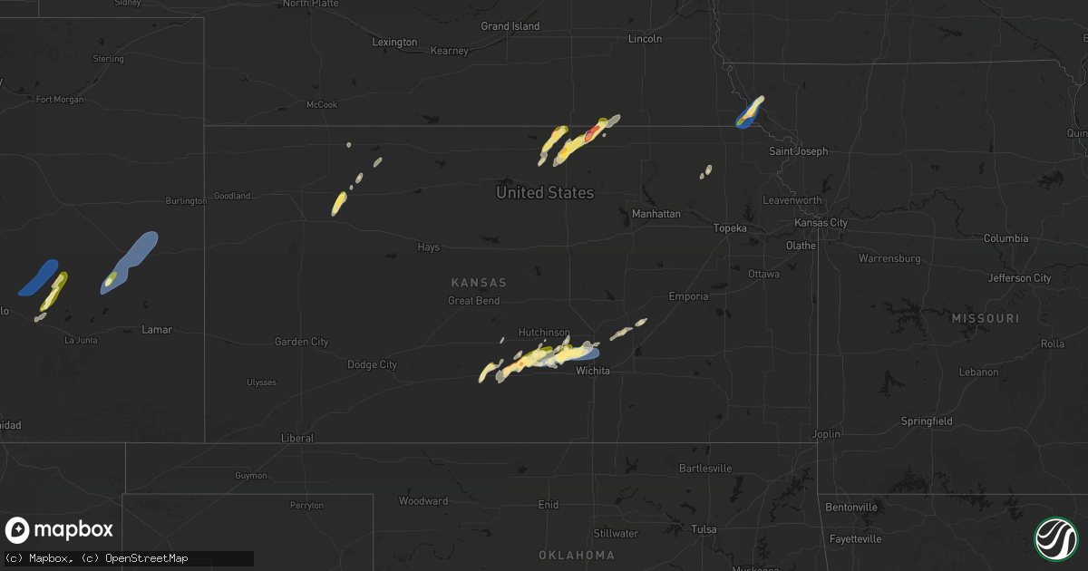
Hail Map in Kansas on April 11, 2026
Get this storm
April 11 map
$229
one time, instant access
Download today. No call, no setup
Keep the $229
Bought the map and want the full workflow? Apply the entire $229 to a subscription within 7 days. None of it is wasted.
Every map, not just this one
This buys you this map. Subscription and you get every map we run, in the markets you choose from a few cities to whole states to nationwide. Plus real-time alerts the moment a storm fires.
Contact data
Name, contact info, occupancy, even credit band for addresses in the footprint. You go from where it hit to who to call.
Become the source they trust
Unlimited branding weather history reports on demand. You already have the documented answer ready for the property owner, and you are the one who showed up with it.
Property data and RoofTrace estimates
Pull up any address you have got, its value and the exact code rules for that jurisdiction, straight from One Click Code. Then RoofTrace estimates the squares, pitch, and roof value, priced the way you price.
Storm reports in Kansas
Kansas
| Date | Description |
|---|---|
| 04/11/20266:30 PM CDT | A local report indicates 60 MPH wind near 4 NE Valley Center |
| 04/11/20266:20 PM CDT | Nickel hail was also reported. |
| 04/11/20265:31 PM CDT | A local report indicates 70 MPH wind near Mount Hope |
| 04/11/20265:30 PM CDT | A local report indicates 79 MPH wind near Mount Hope |
| 04/11/20265:26 PM CDT | A local report indicates 1.50 inch wind near Mount Hope |
| 04/11/20265:26 PM CDT | Delayed report... Four power poles snapped and lines down across 295th w at 93rd st. North. |
| 04/11/20265:21 PM CDT | Power lines knocked down near intersection of east parallel rd and victory rd. |
| 04/11/20265:05 PM CDT | Semi rolled over near k14 and parallel road. Another separate vehicle damaged nearby. |
| 04/11/20264:55 PM CDT | Semi truck and trailer blown over. |
| 04/11/20264:51 PM CDT | Report from mping: half dollar |
| 04/11/20264:50 PM CDT | A local report indicates 1.00 inch wind near 6 SSW Belleville |
| 04/11/20264:33 PM CDT | Mping report. |
| 04/11/20264:30 PM CDT | Corrects previous non-tstm wnd dmg report from 2 wsw oakley. Delayed report. 1/2 mile west of oakley on county road a... Time estimated. Bin for ground cane storage was |
| 04/11/20264:04 PM CDT | A local report indicates 1.00 inch wind near 1 ESE Republic |
| 04/10/20268:39 PM CDT | Kkssaint20 wxunderground. |
| 04/10/20268:21 PM CDT | Ksyf awos reported a 76 mph gust. |
| 04/10/20268:20 PM CDT | Delayed report of an older shed/barn with a tin roof blown off and roof support damaged. Report did state that tires and cinder blocks were holding down the tin roof be |
| 04/10/20268:18 PM CDT | Kkssaint20 |
| 04/10/20268:09 PM CDT | Kkskanor6 |
All States Impacted by Hail Map on April 11, 2026
Cities Impacted by Hail Map on April 11, 2026
- Brigham City, UT
- Pratt, KS
- Turon, KS
- Las Vegas, NM
- Ribera, NM
- Wellsville, UT
- Mendon, UT
- Cunningham, KS
- Logan, UT
- Garden City, UT
- Courtland, KS
- Formoso, KS
- Belleville, KS
- Jewell, KS
- Scandia, KS
- Republic, KS
- Honeyville, UT
- Norton, TX
- Arlington, KS
- Hyrum, UT
- Norway, KS
- Winters, TX
- Kingman, KS
- Pretty Prairie, KS
- Partridge, KS
- Hutchinson, KS
- Fowler, CO
- Olney Springs, CO
- Concordia, KS
- Jamestown, KS
- Hoxie, KS
- Cheney, KS
- Ordway, CO
- Cuba, KS
- Haven, KS
- Mount Hope, KS
- Narka, KS
- Munden, KS
- Burrton, KS
- Winifred, MT
- Big Sandy, MT
- Haddam, KS
- Mahaska, KS
- Reynolds, NE
- Fairbury, NE
- Selden, KS
- Morrowville, KS
- Oberlin, KS
- Billings, MT
- Shepherd, MT
- Snyder, TX
- Karval, CO
- Lloyd, MT
- Morland, KS
- Andale, KS
- Colwich, KS
- Sedgwick, KS
- Bentley, KS
- Valley Center, KS
- Sylvia, KS
- Norcatur, KS
- Endicott, NE
- Wichita, KS
- Diller, NE
- Steele City, NE
- Lenora, KS
- Maize, KS
- Soldier, KS
- Havensville, KS
- Norton, KS
- Goff, KS
- Newton, KS
- Whitewater, KS
- Boone, CO
- Rush, CO
- Yoder, CO
- Haswell, CO
- Kit Carson, CO
- Burns, KS
- Eads, CO
- Albany, TX
- Cedar Point, KS
- Falls City, NE
- Rulo, NE
- Moran, TX
- Craig, MO
- Hiawatha, KS
- Baird, TX
- Mound City, MO
- Fairfax, MO
- Sonora, TX
- Comstock, TX
- Del Rio, TX
- Rocksprings, TX
- Roscoe, SD
- Hosmer, SD
- Leola, SD
- Lone Rock, IA
- Fenton, IA
- Bancroft, IA
- Swea City, IA
- Lakota, IA
- Ledyard, IA
- Blue Earth, MN
- Elmore, MN
- Buffalo Center, IA
- Thompson, IA
- Bricelyn, MN
- Frost, MN
- Leland, IA
- Lake Mills, IA
- Scarville, IA
- Wells, MN
- Emmons, MN
- Alden, MN
- New Richland, MN
- Amery, WI
- Turtle Lake, WI
- Brackettville, TX


