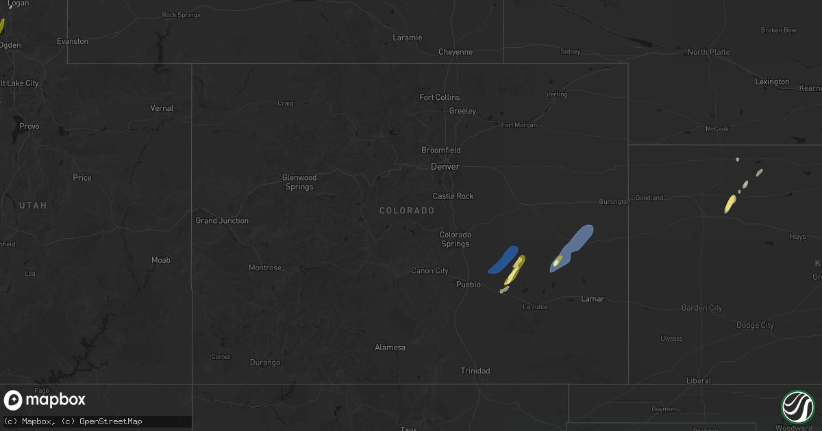
Hail Map in Colorado on April 11, 2026
Get this storm
April 11 map
$229
one time, instant access
Download today. No call, no setup
Keep the $229
Bought the map and want the full workflow? Apply the entire $229 to a subscription within 7 days. None of it is wasted.
Every map, not just this one
This buys you this map. Subscription and you get every map we run, in the markets you choose from a few cities to whole states to nationwide. Plus real-time alerts the moment a storm fires.
Contact data
Name, contact info, occupancy, even credit band for addresses in the footprint. You go from where it hit to who to call.
Become the source they trust
Unlimited branding weather history reports on demand. You already have the documented answer ready for the property owner, and you are the one who showed up with it.
Property data and RoofTrace estimates
Pull up any address you have got, its value and the exact code rules for that jurisdiction, straight from One Click Code. Then RoofTrace estimates the squares, pitch, and roof value, priced the way you price.
Storm reports in Colorado
Colorado
| Date | Description |
|---|---|
| 04/11/20266:54 PM CDT | Kitr reported a 72 mph gust. |
| 04/11/20266:46 PM CDT | Asos station keeo meeker airport. |
| 04/11/20266:39 PM CDT | Mesonet station co068 040w460 u40-firstview. |
| 04/11/20266:14 PM CDT | Up729 |
| 04/11/20266:10 PM CDT | Chaser recorded 70 mph winds and 2 mile visibility in blowing dust. Wind speed measure via handheld anemometer. |
| 04/11/20265:35 PM CDT | Personal weather station measured a 61 mph wind gust. |
| 04/11/20265:15 PM CDT | Local resident reported an outflow wind blew the roof off of his rv barn. An approximately 40ft x 20ft section. |
| 04/11/20261:42 PM CDT | A local report indicates 58 MPH wind near 3 E Rifle |
| 04/10/20268:45 PM CDT | Tt563 site reported a 68 mph gust. |
| 04/10/20268:00 PM CDT | Corrects previous tstm wnd gst report from hale. Tt563 site reported a 68 mph gust. |
| 04/10/20267:57 PM CDT | Mesonet station dhoc2 dead horse... Buford 14ene. |
| 04/10/20267:40 PM CDT | Asos station kitr burlington co airport. |
| 04/10/20267:38 PM CDT | Kcoidali9 |
| 04/10/20267:37 PM CDT | Public report of blowing dust with visibility to 1/2 mile with 60 mph wind gust. |
| 04/10/20267:11 PM CDT | Kcostrat21 |
| 04/10/20267:11 PM CDT | Sevenfarms |
All States Impacted by Hail Map on April 11, 2026
Cities Impacted by Hail Map on April 11, 2026
- Brigham City, UT
- Pratt, KS
- Turon, KS
- Las Vegas, NM
- Ribera, NM
- Wellsville, UT
- Mendon, UT
- Cunningham, KS
- Logan, UT
- Garden City, UT
- Courtland, KS
- Formoso, KS
- Belleville, KS
- Jewell, KS
- Scandia, KS
- Republic, KS
- Honeyville, UT
- Norton, TX
- Arlington, KS
- Hyrum, UT
- Norway, KS
- Winters, TX
- Kingman, KS
- Pretty Prairie, KS
- Partridge, KS
- Hutchinson, KS
- Fowler, CO
- Olney Springs, CO
- Concordia, KS
- Jamestown, KS
- Hoxie, KS
- Cheney, KS
- Ordway, CO
- Cuba, KS
- Haven, KS
- Mount Hope, KS
- Narka, KS
- Munden, KS
- Burrton, KS
- Winifred, MT
- Big Sandy, MT
- Haddam, KS
- Mahaska, KS
- Reynolds, NE
- Fairbury, NE
- Selden, KS
- Morrowville, KS
- Oberlin, KS
- Billings, MT
- Shepherd, MT
- Snyder, TX
- Karval, CO
- Lloyd, MT
- Morland, KS
- Andale, KS
- Colwich, KS
- Sedgwick, KS
- Bentley, KS
- Valley Center, KS
- Sylvia, KS
- Norcatur, KS
- Endicott, NE
- Wichita, KS
- Diller, NE
- Steele City, NE
- Lenora, KS
- Maize, KS
- Soldier, KS
- Havensville, KS
- Norton, KS
- Goff, KS
- Newton, KS
- Whitewater, KS
- Boone, CO
- Rush, CO
- Yoder, CO
- Haswell, CO
- Kit Carson, CO
- Burns, KS
- Eads, CO
- Albany, TX
- Cedar Point, KS
- Falls City, NE
- Rulo, NE
- Moran, TX
- Craig, MO
- Hiawatha, KS
- Baird, TX
- Mound City, MO
- Fairfax, MO
- Sonora, TX
- Comstock, TX
- Del Rio, TX
- Rocksprings, TX
- Roscoe, SD
- Hosmer, SD
- Leola, SD
- Lone Rock, IA
- Fenton, IA
- Bancroft, IA
- Swea City, IA
- Lakota, IA
- Ledyard, IA
- Blue Earth, MN
- Elmore, MN
- Buffalo Center, IA
- Thompson, IA
- Bricelyn, MN
- Frost, MN
- Leland, IA
- Lake Mills, IA
- Scarville, IA
- Wells, MN
- Emmons, MN
- Alden, MN
- New Richland, MN
- Amery, WI
- Turtle Lake, WI
- Brackettville, TX


