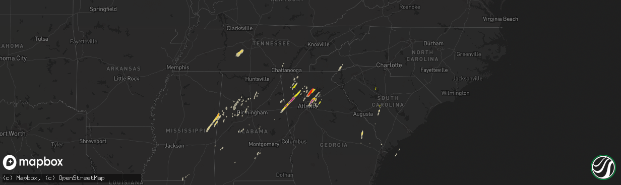
Hail Map on April 11, 2013
The weather event on April 11, 2013 includes Hail map. 8 states and 159 cities were impacted and suffered possible damage. The total estimated number of properties impacted is 71,692.
Want more than just the map?
Turn this storm into a full workflow.
- Owner + property data so you know who to knock
- OnDemand branded weather history reports to win the "did we even have hail?" argument
- RoofTrace estimate so reps stop guessing numbers at the door
Bought this map? Upgrade within 7 days and we'll credit the $230. (10-15 min setup call)
Hail
71,692
Estimated number of impacted properties by a 1.00" hail or larger36,346
Estimated number of impacted properties by a 1.75" hail or larger2,737
Estimated number of impacted properties by a 2.50" hail or largerStates Impacted by Hail Map on April 11, 2013
Storm reports
Georgia
| Date | Description |
|---|---|
| 04/11/20136:55 PM CDT | Multiple large trees down...one against a house. |
| 04/11/20136:55 PM CDT | Numerous trees down in fort oglethorpe. |
| 04/11/20136:45 PM CDT | Tree reported down on house by em on witherow bridge road. |
| 04/11/20136:40 PM CDT | Numerous trees down in the chatsworth area...particularly on the south side of town |
| 04/11/20136:40 PM CDT | This report was received near i75 at exit 315. |
| 04/11/20136:37 PM CDT | Trees down in several locations in the town of dalton. N tibbs road...college dr...crossplains. |
| 04/11/20136:36 PM CDT | Numerous trees reported down with power outages in dawnville. |
| 04/11/20136:25 PM CDT | This report was sent in by a skywarn spotter. |
| 04/11/20136:01 PM CDT | A brief ef1 tornado touched down south of rockmart. The path was approximately 3 tenths of a mile long. About 50 trees were snapped and another 25 or so were uprooted. |
| 04/11/20135:59 PM CDT | Ham radio operator reported quarter sized hail 4 miles south of rockmart. |
| 04/11/20135:58 PM CDT | Baseball sized hail reported at a gas station in rockmart. |
| 04/11/20135:54 PM CDT | Roof blown off small buidling in rome off glen milner and 2nd ave. Small fence downed as well. Eyewitness reports strong gust of wind. |
| 04/11/20135:50 PM CDT | An amateur radio operator reported baseball sized hail in this area. |
| 04/11/20135:41 PM CDT | Tree down at lambert road and highway 25 south. |
| 04/11/20135:35 PM CDT | A tree was reported down in the city on east washington street. |
| 04/11/20135:31 PM CDT | A nws survey confirms that a high end ef0 tornado touched down just south of i20 near chandler rd...continued ne crossing king gin rd and along thomas rd. Three homes s |
| 04/11/20135:30 PM CDT | Tree down on southbound highway 100 at mountain home loop. |
| 04/11/20135:28 PM CDT | Tree down along highway 23 south. |
| 04/11/20135:26 PM CDT | Public reported golf ball sized hail on hwy 100 north of tallapoosa. |
| 04/11/20135:13 PM CDT | Tree down at lambert road and highway 25 south. |
| 04/10/201310:15 PM CDT | A tree was blown down onto highway 520 at fort benning. |
| 04/10/201310:00 PM CDT | Two trees were blown down across highway 116 in harris county. |
| 04/10/20139:56 PM CDT | Report by the public of multiple trees down on power lines on south davis road and highway 27. |
| 04/10/20138:42 PM CDT | Quarter sized hail reported at stone mountain road and rockbridge road. |
| 04/10/20138:29 PM CDT | Quarter sized hail reported 1 mile north of downtown duluth. |
| 04/10/20138:23 PM CDT | The tornado started and ended in lumpkin county...but briefly crossed into hall county. Numerous hardwood and softwood trees were snapped and uprooted. Forty-one homes |
| 04/10/20138:23 PM CDT | Golf ball sized hail reported in duluth. |
| 04/10/20138:20 PM CDT | Spotter reported golfball sized hail on satellite blvd in duluth. |
| 04/10/20138:18 PM CDT | Golf ball sized hail was reported near norcross. |
| 04/10/20137:50 PM CDT | Tree blocking road near forsyth cherokee line. |
| 04/10/20137:45 PM CDT | Some hail stones may have been bigger than golf balls. |
| 04/10/20137:44 PM CDT | Golfball sized hail reported near heardsville road. |
| 04/10/20137:44 PM CDT | Golfball sized hail reported near heardsville road. This is a correction. |
| 04/10/20137:43 PM CDT | Also reported winds to 60 mph. |
Florida
| Date | Description |
|---|---|
| 04/10/201310:16 PM CDT | One tree down at alford rd. And rooks circle |
| 04/10/20139:30 PM CDT | Roof of workshop peeled back due to wind damage |
| 04/10/20139:15 PM CDT | Trees snapped or uprooted. |
| 04/10/20137:30 PM CDT | Measured at the navy whiting field asos. |
Mississippi
| Date | Description |
|---|---|
| 04/11/20132:45 PM CDT | Several large trees were knocked down on 5th avenue between 25th and 26th streets. There was also some fencing in that area that was blown down. |
| 04/11/20132:15 PM CDT | Trees blown over by severe thunderstorm winds. |
| 04/11/20131:55 PM CDT | Several trees blown down by severe thunderstorms winds...just northwest of the community of whister. |
| 04/11/20131:54 PM CDT | Several trees blown over by severe thunderstorm winds. |
| 04/11/20131:50 PM CDT | Trees down and roof of a home damaged in the beaverdam community. |
| 04/11/20131:42 PM CDT | Trees down on jasper county road 6 |
| 04/11/20131:30 PM CDT | Several tops of pine trees snapped off and metal panel roofing blown off of a workshop by severe thunderstorm winds. |
| 04/11/20131:30 PM CDT | Reports of trees down on monroe roads. Power outages on guthrie carter road. Also reports of a tree down in eastabutchie area. |
| 04/11/20131:27 PM CDT | Update...number of trees down...one house with huge pine tree through it...rollup door on fire station blown in...agricultural pivot blown over...outbuilding destroyed |
| 04/11/20131:27 PM CDT | Nickel to quarter sized hail along buchanan rd |
| 04/11/201312:53 PM CDT | A local report indicates 1.75 inch wind near 6 S NEW HOPE |
| 04/11/201312:48 PM CDT | Trees and power lines were blown down along pine grove road near the pine grove community. State police report damage to multiple homes. Numerous trees were also blown |
| 04/11/201312:20 PM CDT | Trained spotter reported tornado on the ground south of macon. |
| 04/11/201312:20 PM CDT | Reports of powerlines down...an 18 wheeler damaged and numerous pine trees snapped near the base. |
| 04/11/201312:10 PM CDT | Heavy damage reported by noxubee 911 near shuqualak. Unknown number of injuries. |
| 04/11/201312:02 PM CDT | Numerous trees down in area around cedar bluff along hwy 50...steeple blown off of a church... |
| 04/11/201311:48 AM CDT | Emergency manager reports path of damage from intersection of hwy 495 and old jackson road...northeast across highway 16 just east of hwy 493 to intersection of hwy 397 |
Tennessee
| Date | Description |
|---|---|
| 04/11/20136:39 PM CDT | One tree down on signal mountain. |
| 04/11/20136:20 PM CDT | 1 tree down. |
| 04/11/20136:10 PM CDT | Several trees down. |
| 04/11/20133:13 PM CDT | Trees and power lines down in northwest jackson county. |
| 04/10/201311:20 PM CDT | Several trees down around the piney flats area. |
| 04/10/20138:05 PM CDT | Trees down across county. |
| 04/10/20137:30 PM CDT | Around 1400 people without power. Likely due to gusty winds. |
| 04/10/20137:10 PM CDT | 1 tree down. |
Alabama
| Date | Description |
|---|---|
| 04/11/20135:51 PM CDT | E30+ trees down. Several snapped off above ground. At water treatment plant. |
| 04/11/20135:30 PM CDT | Multiple warehouses sustained roof damage. |
| 04/11/20135:15 PM CDT | Multiple trees were knocked down on county road 155 between county road 200 and county road 18 in montevallo. At least 10 trees blocked the roadway. |
| 04/11/20135:15 PM CDT | A tree was blown down along county road 37. Time estimated from radar. |
| 04/11/20135:15 PM CDT | A small outbuilding was destroyed due to fallen tree in the 18000 block of county road 49. |
| 04/11/20135:12 PM CDT | Pea size hail was reported. |
| 04/11/20135:00 PM CDT | A tree was knocked down along county road 10 near county road 41. |
| 04/11/20134:55 PM CDT | At least a dozen trees were blown down across a one mile area near timberline golf course along and near the intersection of highway 25 and interstate 65. Single tree d |
| 04/11/20134:51 PM CDT | Two to three dozen trees were blown down. Several were snapped off above ground at water treatment plant. |
| 04/11/20134:48 PM CDT | Tree reported down on house. |
| 04/11/20134:48 PM CDT | Several trees were blown down near the intersection of state highway 155 and county road 200. Winds were estimated at 50 mph. |
| 04/11/20134:45 PM CDT | Trees and powerlines reported down. |
| 04/11/20134:38 PM CDT | A building at marshall space flight center reported wind damage. |
| 04/11/20134:37 PM CDT | Multiple large trees reported down at the intersection of hickory hill road and four mile post road. |
| 04/11/20134:37 PM CDT | A tree was blown down on valley view drive. |
| 04/11/20134:34 PM CDT | Trees...multiple powerlines...and downed power poles at the north end of the intersection of whitesburg drive and lily flagg road. |
| 04/11/20134:32 PM CDT | A brief ef-1 tornado touched down along dug hill road near cheval blvd where large cedar trees were snapped and twisted along with several snapped wooden power poles. A |
| 04/11/20134:30 PM CDT | Roof damage to a barn was reported. |
| 04/11/20134:29 PM CDT | Damage was reported to a mini-store at the intersection of lily flagg road and whitesburg drive. |
| 04/11/20134:27 PM CDT | Trees were blown down along highway 82 near mile marker 93. The eastbound lanes were blocked for a short period of time. |
| 04/11/20134:25 PM CDT | A brief ef-1 tornado touched down on the west side of memorial parkway near the 9000 block of craigmont drive causing several large trees to be uprooted and snapped. It |
| 04/11/20134:22 PM CDT | More than a dozen trees snapped along state highway 219 a few miles south of centreville. The road was blocked for a short time. Time estimated from radar. Trees were a |
| 04/11/20134:18 PM CDT | Numerous trees were snapped off and uprooted along a 20 mile path from se of harrisburg to se of brierfield. One home suffered minor siding damage. |
| 04/11/20133:59 PM CDT | Power lines were blown down on peters road off highway 77. |
| 04/11/20133:30 PM CDT | A tree was reported blown down on cr 351. |
| 04/11/20133:30 PM CDT | Trees down across the road on cr 1051 in the sardis community. |
| 04/11/20133:26 PM CDT | *** 1 inj *** a brief tornado touched down near the intersection of county road 45 and county road 3734. This location is east southest of addison. Many trees were snap |
| 04/11/20133:26 PM CDT | *** 1 inj *** a brief tornado touched down near cr 6 and cr 3734. This location is east southest of addison. Many trees were snapped off or were uprooted along the shor |
| 04/11/20133:25 PM CDT | *** 1 inj *** unknown structural damage along county road 45 near countyroad 3734. At least one man was injured. Time estimated from radar. |
| 04/11/20133:11 PM CDT | A tornado touched down near the winston county airport. The tornado snapped off and uprooted numerous trees. Several homes were damaged by fallen trees. A few boathouse |
| 04/11/20133:10 PM CDT | A tornado touched down near the winston county airport. The tornado snapped off and uprooted numerous trees. Several homes were damaged by fallen trees. A few boathouse |
| 04/11/20133:03 PM CDT | Em reports trees down 1 w of pennington on hwy 156. |
| 04/11/20132:57 PM CDT | A tornado touched down near county road 21 and traveled northeast. It lifted just east of highway 195. Several trees were snapped off and uprooted along the path. At le |
| 04/11/20132:45 PM CDT | Time and lat/long corrected. Trees were blown down and blocked road near intersection of nauvoo and nix roads. Structure damage was also reported in this area. Time est |
| 04/11/20132:45 PM CDT | A tornado touched down near dogtown road and traveled northeast. The tornado lifted as it crossed slick lizzard road. Numerous trees were snapped or uprooted and a few |
| 04/11/20132:43 PM CDT | Trees were blwon down and blocked road near intersection of nauvoo and nix roads. Structure damage was also reported in this area. Time estimated from radar. |
| 04/11/20132:30 PM CDT | Several trees down along county road 35. One tree fell on a house. There was also roof damage to a barn and a small outbuilding was destroyed at the same residence. No |
| 04/11/20132:03 PM CDT | A tree and power pole blown were blown down on 7th street se. |
| 04/11/20132:00 PM CDT | A few trees and power lines were blown down along 7th street ne and also across from walmart. Time estimated from radar. |
| 04/11/20131:35 PM CDT | Trees were blown down along county road 49 south of kennedy. Time estimated from radar. |
| 04/11/201312:57 PM CDT | Trees and power lines were blown down along pine grove road near the pine grove community. State police report damage to multiple homes. Numerous trees were also blown |
| 04/10/201310:05 PM CDT | Numerous trees and powerlines reported down around dothan and northern houston county. |
| 04/10/201310:02 PM CDT | Tree down west of abbeville on highway 10. |
| 04/10/20139:32 PM CDT | A few trees were blown down along county road 89. |
| 04/10/20139:30 PM CDT | Tree down across the highway near ozark. Caused a vehicle accident. No injuries. |
| 04/10/20139:29 PM CDT | Tree down on a mobile home west of slocomb. |
| 04/10/20138:47 PM CDT | Several powerlines reported down near samson on cr 54. |
| 04/10/20138:44 PM CDT | *** 1 inj *** around one dozen structures were damaged or destroyed and hundreds of trees were blown down along the path.one person was injured by flying glass in a hom |
| 04/10/20138:42 PM CDT | Possible tornado. Unconfirmed- highway patrol reporting structural damage between notasulga and liberty city. Rescue is enroute. |
| 04/10/20138:34 PM CDT | *** 1 inj *** around one dozen structures were damaged or destroyed and hundreds of trees were blown down along the path.one person was injured by flying glass in a hom |
| 04/10/20137:28 PM CDT | A large tree were blown down and blocked the road near the intersection of mcinnis road and patterson road. Time estimated from radar. |
| 04/10/20137:20 PM CDT | Multiple trees were snapped and uprooted just off highway 331 behind sportsman deer processing. Time estimated from radar. |
Kentucky
| Date | Description |
|---|---|
| 04/11/20136:25 PM CDT | Tree blown down and blocking a portion of i-64 near mile marker 135. |
| 04/11/20136:19 PM CDT | A tree was blown down in the woodbine community. |
| 04/11/20136:18 PM CDT | Trees and powerlines were blown down on ky hwy 211 in moores ferry. |
| 04/11/20136:18 PM CDT | A power pole was blown down onto a home in the stulltown community near preston. |
| 04/11/20136:16 PM CDT | Two trees were blown down on us hwy 60 and moores ferry road in salt lick. |
| 04/11/20136:05 PM CDT | A power pole was blown down onto a home in the stulltown community near preston. |
| 04/11/20135:55 PM CDT | Numerous trees and powerlines were blown down between camrago and jeffersonville between 655 and 705 pm edt. Several barns were also destroyed and homes in the area suf |
| 04/11/20135:55 PM CDT | Carport and large tree blown down. |
| 04/11/20135:30 PM CDT | A few trees and limbs were reported down between broadhead and mount vernon along old us highway 150. |
| 04/11/20135:28 PM CDT | Awos reported 53 knot gust |
| 04/11/20135:18 PM CDT | Shallow rooted trees down. Pictures relayed via twitter |
| 04/11/20133:43 PM CDT | Local em director reported some cedar trees down as well as shingles blown off of a few houses and tin off of barns on free ferry and smith grove rds. |
Virginia
| Date | Description |
|---|---|
| 04/11/20134:50 AM CDT | Measured gust on spears mountain |
| 04/11/20134:00 AM CDT | A tree was blown down across sandy road. |
| 04/11/20133:55 AM CDT | A tree was blown down along anderson mill road. |
| 04/11/20133:18 AM CDT | Three homes damaged...two cars damamged...a garage destroyed...and several trees and powerlines down on chestnut oak drive. Also...a window blew out of a church on fair |
| 04/11/20131:40 AM CDT | Carroll county emergency management reported five buildings damaged and several trees down. A storage shed was pushed into one of the buildings. |
Louisiana
| Date | Description |
|---|---|
| 04/11/20131:21 PM CDT | Trees down on the west side of the town of pearl river. |
| 04/11/20131:18 PM CDT | Roof blown off of a house in the community of pine. |
| 04/11/20131:08 PM CDT | Trees blown down near the intersection of highway 1072 and highway 60. |
| 04/11/20131:08 PM CDT | A power line was knocked down. |
| 04/11/20131:08 PM CDT | Roof damage to a house. |
| 04/11/20131:05 PM CDT | Thunderstorm wind damage in the oakmont subdivision off airport road in slidell. Several trees were snapped...a number of roofs received minor damage...fences were blow |
| 04/11/20131:05 PM CDT | Nws survey finds a ef0 tornado in slidell. Survey team is still out finding the point of touchdown. |
| 04/11/20131:05 PM CDT | A weak tornado touched down on a intermittent path just south of the slidell airport. A few large trees were snapped or uprooted...large tree limbs snapped...and power |
| 04/11/20131:05 PM CDT | A weak tornado touched down on a intermittent path just south of the slidell airport. A few large trees were snapped or uprooted...large tree limbs snapped...and power |
| 04/11/20131:05 PM CDT | National weather service employee estimated wind gusts of 70 mph on airport road in slidell. Siding was blown off of a house. |
| 04/11/201312:52 PM CDT | Nws survey finds a ef0 tornado in slidell. Survey team is still out finding the point of touchdown. |
| 04/11/201312:52 PM CDT | National weather service employee estimated wind gusts of 70 mph on airport road in slidell. Siding was blown off of a house. |
| 04/11/201312:52 PM CDT | Thunderstorm wind damage in the oakmont subdivision off airport road in slidell. Several trees were snapped...a number of roofs received minor damage...fences were blow |
| 04/11/201312:50 PM CDT | Measured at the drawbridge on the causeway. |
| 04/11/201312:25 PM CDT | Trees were blown down between folsom and covington. |
South Carolina
| Date | Description |
|---|---|
| 04/11/20135:30 PM CDT | Public reported quarter sized hail in pelion |
| 04/11/20135:12 PM CDT | Highway patrol reported two trees down near salley. |
| 04/10/20137:25 PM CDT | Public reported quarter size hail along stevenson road. Also power out in the area. |
| 04/10/20137:10 PM CDT | Quarter sized hail reported along sc 34 near the broad river. |
| 04/10/20137:05 PM CDT | Reported trees down near the intersection of mount pleasant road and sc highway 34. |
North Carolina
| Date | Description |
|---|---|
| 04/11/20136:25 AM CDT | A tree was blown down along rascoe dameron road. |
| 04/11/20134:40 AM CDT | Trees down on holly springs rd and hinshaw town rd. Radar estimated time. |
| 04/11/20134:40 AM CDT | Large tree down on nc705 at jasper road and ashwood road. Time approximated from radar signature. |
| 04/11/20134:35 AM CDT | Trees completely blocking little bean store rd. Radar estimated time. |
| 04/11/20134:35 AM CDT | A tree was blown down across highway 86n. A truck traveling the highway struck the fallen tree. |
| 04/11/20134:35 AM CDT | Trees down on picketmill rd. Radar estimated time. |
| 04/11/20134:33 AM CDT | Tree blown down at tommy cox road and hinshaw town road. Time estimated. |
| 04/11/20134:30 AM CDT | Large trees down in the 300-400 block of little river rd. Radar estimated time. |
| 04/11/20134:30 AM CDT | Tree blown down on piney ridge church road. Time estimated. |
| 04/11/20134:24 AM CDT | Tree blown down on a house on little river road. Time estimated. |
| 04/11/20134:20 AM CDT | A tree was blown down along highway 700. |
| 04/11/20133:30 AM CDT | A few trees and powerlines were blown down along highway 311. |
| 04/11/20133:25 AM CDT | A tree was blown down near the intersection of stone mountain road and ponderosa road. |
| 04/11/20133:20 AM CDT | Large tree down on red bank road. Time approximate by radar signature. |
| 04/11/20133:15 AM CDT | One tree down on baux mountain road. Time approximated by radar. |
| 04/11/20133:10 AM CDT | Tree blown down along highway 66. Time estimated. |
| 04/11/20133:10 AM CDT | Tree blown down along providence church road. Time estimated. |
| 04/11/20132:35 AM CDT | A large tree was blown down and was blocking highway 268. |
| 04/11/20132:30 AM CDT | A large tree was blown down near the intersection of little mountain church road and creed road. |
| 04/10/20139:04 PM CDT | Trees down near the intersection of old mountain road and us highway 70. |
| 04/10/20138:58 PM CDT | Reports of trees down near maiden |
| 04/10/20138:39 PM CDT | Up to 1 inch hail around lake toxaway. |
Cities Impacted by Hail Map on April 11, 2013
- Chatsworth, GA
- Ethelsville, AL
- Columbus, MS
- Macon, MS
- Brooksville, MS
- Blackville, SC
- Springfield, SC
- Dunlap, TN
- Garfield, GA
- Millen, GA
- Twin City, GA
- Portal, GA
- Carrollton, AL
- Aliceville, AL
- Tallapoosa, GA
- Peachtree Corners, GA
- Decatur, GA
- Lawrenceville, GA
- Tucker, GA
- Duluth, GA
- Suwanee, GA
- Norcross, GA
- Lilburn, GA
- Atlanta, GA
- Piedmont, AL
- Loganville, GA
- Woodstock, GA
- Canton, GA
- Ball Ground, GA
- Dawsonville, GA
- Cumming, GA
- Alpharetta, GA
- Salley, SC
- North, SC
- Neeses, SC
- Northport, AL
- Rockmart, GA
- Muscadine, AL
- Buchanan, GA
- Brent, AL
- Lake Toxaway, NC
- Sapphire, NC
- Shuqualak, MS
- De Kalb, MS
- Preston, MS
- Rincon, GA
- Cedartown, GA
- Stone Mountain, GA
- Clarkston, GA
- Pine Lake, GA
- Marietta, GA
- Columbia, MS
- Balsam Grove, NC
- Santa Fe, TN
- Hohenwald, TN
- Williamsport, TN
- Mount Pleasant, TN
- Duck River, TN
- Hampshire, TN
- Centerville, TN
- Flowery Branch, GA
- Gainesville, GA
- Oakwood, GA
- Buford, GA
- Bremen, AL
- Taylorsville, GA
- Rome, GA
- Kingston, GA
- Letohatchee, AL
- Fort Deposit, AL
- White, GA
- Millport, AL
- Reform, AL
- Calhoun, GA
- Blountsville, AL
- Hanceville, AL
- Holly Pond, AL
- Baileyton, AL
- Hayden, AL
- Cullman, AL
- Brooklet, GA
- Ward, AL
- Pennington, AL
- Butler, AL
- Jasper, AL
- Roswell, GA
- Berry, AL
- Nauvoo, AL
- Townley, AL
- Carbon Hill, AL
- Arley, AL
- Double Springs, AL
- Houston, AL
- Ashland, AL
- Aragon, GA
- Montevallo, AL
- Winder, GA
- Dalton, GA
- Gordo, AL
- Covington, LA
- Madisonville, LA
- Plainville, GA
- Resaca, GA
- Adairsville, GA
- Sugar Valley, GA
- Heflin, AL
- Cartersville, GA
- Swansea, SC
- Pelion, SC
- Golden Meadow, LA
- Adger, AL
- Bessemer, AL
- Whitwell, TN
- Fruithurst, AL
- Jasper, GA
- Greenville, AL
- Braselton, GA
- Hoschton, GA
- Conyers, GA
- Gardendale, AL
- Graysville, AL
- Dora, AL
- Bankston, AL
- Fayette, AL
- Mulga, AL
- Quinton, AL
- Adamsville, AL
- Monroe, GA
- Dacula, GA
- Waleska, GA
- Foxworth, MS
- Sandy Hook, MS
- Snellville, GA
- Brookwood, AL
- Tuscaloosa, AL
- Martin, SC
- Kennedy, AL
- Parrish, AL
- Franklin, AL
- Ponchatoula, LA
- Metter, GA
- Marion, AL
- Pomaria, SC
- Blair, SC
- Lakeview, TX
- Childress, TX
- Memphis, TX
- Silverton, TX
- Quitaque, TX
- Tulia, TX
- Clarendon, TX
- Happy, TX
- Plainview, TX
- Hale Center, TX
- Matador, TX
- Turkey, TX
- Cee Vee, TX
- Paducah, TX
- Quanah, TX