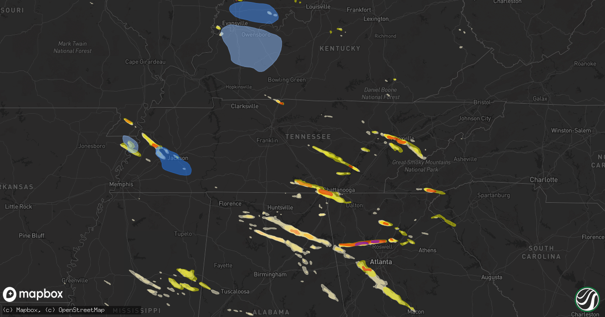
Hail Map in Tennessee on April 10, 2025
Get this storm
April 10 map
$229
one time, instant access
Download today. No call, no setup
Keep the $229
Bought the map and want the full workflow? Apply the entire $229 to a subscription within 7 days. None of it is wasted.
Every map, not just this one
This buys you this map. Subscription and you get every map we run, in the markets you choose from a few cities to whole states to nationwide. Plus real-time alerts the moment a storm fires.
Contact data
Name, contact info, occupancy, even credit band for addresses in the footprint. You go from where it hit to who to call.
Become the source they trust
Unlimited branding weather history reports on demand. You already have the documented answer ready for the property owner, and you are the one who showed up with it.
Property data and RoofTrace estimates
Pull up any address you have got, its value and the exact code rules for that jurisdiction, straight from One Click Code. Then RoofTrace estimates the squares, pitch, and roof value, priced the way you price.
Storm reports in Tennessee
Tennessee
| Date | Description |
|---|---|
| 04/10/20256:35 PM CDT | A few trees down on hickman rd. Time estimated. |
| 04/10/20256:28 PM CDT | Time estimated from radar. |
| 04/10/20255:48 PM CDT | Large tree down at greenfield and rogana road. |
| 04/10/20255:45 PM CDT | Smyrna awos. |
| 04/10/20255:41 PM CDT | Bna asos. |
| 04/10/20255:40 PM CDT | Covered the roadway. |
| 04/10/20255:40 PM CDT | Tree down in triune. |
| 04/10/20255:40 PM CDT | A local report indicates 1.00 inch wind near 3 NE Wears Valley |
| 04/10/20255:30 PM CDT | Trees and power lines down. |
| 04/10/20255:30 PM CDT | Tree on house. |
| 04/10/20255:30 PM CDT | Part of thousand hills cowboy church roof removed. |
| 04/10/20255:30 PM CDT | Mesonet station 0679w vanderbilt university. |
| 04/10/20255:24 PM CDT | Tree on house. Time estimated from radar. |
| 04/10/20255:22 PM CDT | Power lines across buffalo road. |
| 04/10/20255:20 PM CDT | A local report indicates 1.00 inch wind near Maryville |
| 04/10/20255:20 PM CDT | Tree across road holly tree gap south of manly road. |
| 04/10/20255:17 PM CDT | Multiple trees down on railroad bed road. |
| 04/10/20255:16 PM CDT | Tree down on donelson pike. |
| 04/10/20255:15 PM CDT | Hail odd and slushy... Lasted for three to four minutes. |
| 04/10/20255:15 PM CDT | Tree across road and power lines. |
| 04/10/20255:14 PM CDT | At john c tune airport. |
| 04/10/20255:14 PM CDT | Power line down near hillsboro hs. |
| 04/10/20255:13 PM CDT | Tree blocking woodlawn drive. |
| 04/10/20255:13 PM CDT | Multiple trees down on old hickory blvd in bells bend. |
| 04/10/20255:10 PM CDT | Large tree snapped on kimpalong dr. |
| 04/10/20255:09 PM CDT | Tree on house. |
| 04/10/20255:05 PM CDT | A local report indicates 1.50 inch wind near 2 SE Lake Forest |
| 04/10/20254:55 PM CDT | A local report indicates 1.00 inch wind near 1 NNW Bearden |
| 04/10/20254:54 PM CDT | Reports of trees and powerlines down along hwy 12 between henrietta and ashland city. A brush fire was started from downed powerlines near saddle tree rd. |
| 04/10/20254:42 PM CDT | A local report indicates 1.25 inch wind near 3 SSE Karns |
| 04/10/20254:41 PM CDT | Several trees down on jones hollow rd. Time estimated. |
| 04/10/20254:40 PM CDT | Hail just under two inches wide fell just south of dayton tn. Report relayed via social media. |
| 04/10/20254:40 PM CDT | Time adjusted for radar... 1.5 inch hail measured just south of dayton... Tn. |
| 04/10/20254:40 PM CDT | A local report indicates 1.25 inch wind near 3 NNE Soddy-Daisy |
| 04/10/20254:40 PM CDT | A local report indicates 1.00 inch wind near 1 ENE Finger |
| 04/10/20254:38 PM CDT | Golf ball sized hail reported by 2 different people in hardin valley area. |
| 04/10/20254:37 PM CDT | Lots of small hail... Largest was up to one inch in diameter. |
| 04/10/20254:35 PM CDT | Time adjusted by radar... Report relayed by ham. |
| 04/10/20254:34 PM CDT | A local report indicates 1.00 inch wind near 2 WSW Henderson |
| 04/10/20254:32 PM CDT | A local report indicates 1.00 inch wind near 2 SW South Pittsburg |
| 04/10/20254:30 PM CDT | A local report indicates 1.00 inch wind near 1 SSW Ten Mile |
| 04/10/20254:20 PM CDT | Golf ball sized hail reported near solway... Video from report shows fairly slushy hail impacting and disintegrating against car windshield. |
| 04/10/20254:18 PM CDT | Nickel to quarter sized hail falling on us-127 south of pikeville. |
| 04/10/20254:16 PM CDT | Trees down on lee hollow rd. Time estimated. |
| 04/10/20254:15 PM CDT | Corrects previous hail report from 2 sw south pittsburg. |
| 04/10/20254:13 PM CDT | Hail up to 1.75 inches. |
| 04/10/20254:13 PM CDT | A local report indicates 1.00 inch wind near 1 NW Old Cumberland |
| 04/10/20254:11 PM CDT | A local report indicates 1.00 inch wind near 2 NNW Oak Ridge |
| 04/10/20254:10 PM CDT | Up to 1 inch hail observed near airways/hwy45. |
| 04/10/20254:07 PM CDT | Asos station kmkl jackson. |
| 04/10/20254:06 PM CDT | Report from mping: quarter |
| 04/10/20254:06 PM CDT | A local report indicates 1.00 inch wind near 2 N Oak Ridge |
| 04/10/20254:05 PM CDT | Ham spotter reports quarter sized hail on brocdell road northwest of the mt glen rv park. |
| 04/10/20254:05 PM CDT | Report from mping: quarter |
| 04/10/20254:05 PM CDT | Hail ranged from quarter to golf ball sized in south pittsburg. |
| 04/10/20254:02 PM CDT | Large tree limbs downed in the purdy area. |
| 04/10/20254:02 PM CDT | Tree and power pole fell on a mobile home. Time estimated. |
| 04/10/20253:58 PM CDT | Reports of hail up to golf ball size on the west side of portland... Including college st. Pictures on social media confirm. |
| 04/10/20253:55 PM CDT | Trees down. |
| 04/10/20253:38 PM CDT | A local report indicates 1.25 inch wind near 1 E Maury City |
| 04/10/20253:36 PM CDT | Report from mping: half dollar |
| 04/10/20253:33 PM CDT | A local report indicates 1.75 inch wind near 3 S Chestnut Bluff |
| 04/10/20253:32 PM CDT | Quarter to half dollar sized hail. |
| 04/10/20253:31 PM CDT | Metal roof blown off on concord rd at wilkes outside of gates... Tn. |
| 04/10/20253:31 PM CDT | Report from mping: quarter |
| 04/10/20253:30 PM CDT | A local report indicates 1.00 inch wind near Halls |
| 04/10/20253:30 PM CDT | A local report indicates 1.00 inch wind near Gates |
| 04/10/20253:30 PM CDT | Spotter confirmed quarter sized hail along the crockett/lauderdale county line. |
| 04/10/20253:25 PM CDT | A local report indicates 1.25 inch wind near 4 S Winchester |
| 04/10/20253:20 PM CDT | A local report indicates 1.00 inch wind near 1 N Dyersburg |
| 04/10/20253:18 PM CDT | A local report indicates 1.00 inch wind near 1 N Dyersburg |
| 04/09/20258:15 PM CDT | A local report indicates 1.25 inch wind near 5 W Pikeville |
| 04/09/20257:15 PM CDT | Corrects previous hail report from 5 w pikeville. Corrected for time. |
All States Impacted by Hail Map on April 10, 2025
Cities Impacted by Hail Map on April 10, 2025
- Hawk Point, MO
- Warrenton, MO
- Troy, MO
- Wright City, MO
- Moscow Mills, MO
- Foristell, MO
- Wentzville, MO
- Lake Saint Louis, MO
- O'Fallon, MO
- Saint Peters, MO
- Saint Charles, MO
- Labadie, MO
- Villa Ridge, MO
- Gray Summit, MO
- Pacific, MO
- Chesterfield, MO
- Wildwood, MO
- Ballwin, MO
- Hilham, TN
- Gainesboro, TN
- Whitleyville, TN
- Dittmer, MO
- Olmstead, KY
- Cookeville, TN
- Mill Shoals, IL
- Burnt Prairie, IL
- Mount Vernon, IN
- Carmi, IL
- Grayville, IL
- Crossville, IL
- Winchester, TN
- Belvidere, TN
- Adairville, KY
- Ewing, IL
- Macedonia, IL
- Benton, IL
- Fairfield, IL
- Finley, TN
- Golden Gate, IL
- Dyersburg, TN
- Halls, TN
- Blytheville, AR
- Luxora, AR
- Dell, AR
- Russellville, KY
- Princeton, IN
- Oliver Springs, TN
- Sunbright, TN
- Deer Lodge, TN
- Uniontown, KY
- Morganfield, KY
- Decherd, TN
- Cowan, TN
- Sewanee, TN
- Wartburg, TN
- Harriman, TN
- Ripley, TN
- Friendship, TN
- Alamo, TN
- Bells, TN
- Osceola, AR
- Waverly, KY
- Gates, TN
- Sherwood, TN
- Mulberry, TN
- Patoka, IN
- Francisco, IN
- South Pittsburg, TN
- Henning, TN
- Brownsville, TN
- Spencer, TN
- Rock Island, TN
- Hanson, KY
- Manitou, KY
- Nebo, KY
- Madisonville, KY
- Sacramento, KY
- Bremen, KY
- White Plains, KY
- Earlington, KY
- Mortons Gap, KY
- Sebree, KY
- Slaughters, KY
- Utica, KY
- Calhoun, KY
- Rumsey, KY
- Owensboro, KY
- Island, KY
- Greenville, KY
- Central City, KY
- Philpot, KY
- Graham, KY
- Livermore, KY
- Centertown, KY
- Jasper, TN
- Guild, TN
- Bryant, AL
- Trenton, GA
- Spring City, TN
- Grandview, TN
- Rockwood, TN
- Gadsden, TN
- Oakdale, TN
- Oak Ridge, TN
- Ten Mile, TN
- Jackson, TN
- Humboldt, TN
- Denmark, TN
- Whiteville, TN
- Mercer, TN
- Medon, TN
- Beech Bluff, TN
- Pinson, TN
- Henderson, TN
- Toone, TN
- Dixon, KY
- Providence, KY
- Robards, KY
- Corydon, KY
- Poseyville, IN
- Evansville, IN
- Wadesville, IN
- Henderson, KY
- New Harmony, IN
- Haubstadt, IN
- Owensville, IN
- Cynthiana, IN
- Fort Branch, IN
- Reed, KY
- Spottsville, KY
- Boonville, IN
- Chandler, IN
- Newburgh, IN
- Elberfeld, IN
- Oakland City, IN
- Lynnville, IN
- Chrisney, IN
- Dale, IN
- Winslow, IN
- Tennyson, IN
- Stendal, IN
- Spurgeon, IN
- Gentryville, IN
- Huntingburg, IN
- Velpen, IN
- Richland, IN
- Rockport, IN
- Lincoln City, IN
- Grandview, IN
- Holland, IN
- Santa Claus, IN
- Maceo, KY
- Lamar, IN
- Whitesville, KY
- Hawesville, KY
- Hartford, KY
- Lewisport, KY
- Reynolds Station, KY
- Powderly, KY
- Beaver Dam, KY
- Rockport, KY
- Beech Creek, KY
- Drakesboro, KY
- Knoxville, TN
- Rossville, GA
- Flintstone, GA
- Lookout Mountain, GA
- Lookout Mountain, TN
- Chattanooga, TN
- Pikeville, TN
- Ferdinand, IN
- Evanston, IN
- Wildwood, GA
- Rising Fawn, GA
- Finger, TN
- Bethel Springs, TN
- McHenry, KY
- Dundee, KY
- Rosine, KY
- Falls Of Rough, KY
- Belton, KY
- Beechmont, KY
- Browder, KY
- Caneyville, KY
- Olaton, KY
- Cromwell, KY
- Horse Branch, KY
- Fordsville, KY
- Cloverport, KY
- Rochester, KY
- Morgantown, KY
- Dunmor, KY
- Chickamauga, GA
- Fort Oglethorpe, GA
- Bloomfield, KY
- Soddy Daisy, TN
- Graysville, TN
- Dunlap, TN
- Saint Meinrad, IN
- Bristow, IN
- Birdseye, IN
- Leopold, IN
- Troy, IN
- Tell City, IN
- Ringgold, GA
- Rock Spring, GA
- Rockford, TN
- Louisville, TN
- Lenoir City, TN
- Bridgeport, AL
- Attalla, AL
- Steele, AL
- Gadsden, AL
- Tunnel Hill, GA
- Rocky Face, GA
- Seymour, TN
- Farragut, TN
- Etowah, TN
- Springfield, KY
- Bardstown, KY
- Willisburg, KY
- Piedmont, AL
- Iuka, IL
- Sevierville, TN
- Walland, TN
- Decatur, AL
- Savannah, TN
- Lutts, TN
- Maryville, TN
- Friendsville, TN
- Tanner, AL
- Pigeon Forge, TN
- Somerville, AL
- Gatlinburg, TN
- Moulton, AL
- Courtland, AL
- Hillsboro, AL
- Town Creek, AL
- Marshall, NC
- Guntersville, AL
- Madison, AL
- Russellville, AL
- Ellijay, GA
- Hartselle, AL
- Trinity, AL
- Union Grove, AL
- Laceys Spring, AL
- Valhermoso Springs, AL
- Albertville, AL
- Estillfork, AL
- Talking Rock, GA
- Boaz, AL
- Como, MS
- Jasper, GA
- Crossville, AL
- Arab, AL
- Dawsonville, GA
- Cedartown, GA
- Aragon, GA
- Rockmart, GA
- Mcminnville, TN
- Vinemont, AL
- Danville, AL
- Addison, AL
- Otto, NC
- Marble Hill, GA
- Mount Hope, AL
- Woodbury, TN
- Ball Ground, GA
- Lula, GA
- Pekin, IN
- Salem, IN
- Gainesville, GA
- Tate, GA
- Collinsville, AL
- Cave Spring, GA
- Dallas, GA
- Taylorsville, GA
- Cartersville, GA
- Scottsboro, AL
- Henryville, IN
- Underwood, IN
- Scaly Mountain, NC
- Falkville, AL
- Highlands, NC
- Franklin, NC
- Valley Head, AL
- Leesburg, AL
- Cullman, AL
- Centre, AL
- Eastanollee, GA
- Toccoa, GA
- Fair Play, SC
- Westminster, SC
- Lavonia, GA
- Martin, GA
- Holly Pond, AL
- Otisco, IN
- Eva, AL
- Baileyton, AL
- Sweetwater, TN
- Philadelphia, TN
- Maysville, GA
- Commerce, GA
- Cumming, GA
- Memphis, IN
- London, KY
- Byhalia, MS
- Hartwell, GA
- Marysville, IN
- Lily, KY
- Corbin, KY
- Acworth, GA
- Woodstock, GA
- Emerson, GA
- Oakwood, GA
- Dana, KY
- Blountsville, AL
- Cornelia, GA
- Alpharetta, GA
- Horton, AL
- Altoona, AL
- Henagar, AL
- Pisgah, AL
- Sylvania, AL
- Fort Payne, AL
- Mentone, AL
- Roswell, GA
- Portland, TN
- Ivel, KY
- Betsy Layne, KY
- Harold, KY
- Banner, KY
- Cross Plains, TN
- Orlinda, TN
- Dacula, GA
- Tomahawk, KY
- Boons Camp, KY
- Paintsville, KY
- Cottontown, TN
- Talmo, GA
- Pendergrass, GA
- Kennesaw, GA
- Hoschton, GA
- Marietta, GA
- Springfield, TN
- Braselton, GA
- Jefferson, GA
- Starr, SC
- Anderson, SC
- Oneonta, AL
- Gallant, AL
- Auburn, GA
- Buford, GA
- Ashville, AL
- Buchanan, GA
- Wilsondale, WV
- Kermit, WV
- Williamsburg, KY
- Suwanee, GA
- Rainbow City, AL
- Ragland, AL
- Ohatchee, AL
- Bremen, GA
- Debord, KY
- Crum, WV
- Temple, GA
- Lincoln, AL
- Anniston, AL
- Alexandria, AL
- Ripley, WV
- Villa Rica, GA
- Warfield, KY
- Winston, GA
- Douglasville, GA
- Palmetto, GA
- Fairburn, GA
- Talladega, AL
- Munford, AL
- Oxford, AL
- Eastaboga, AL
- Sharpsburg, GA
- Union City, GA
- Roopville, GA
- Newnan, GA
- Woodland, AL
- Graham, AL
- Delta, AL
- Carrollton, GA
- Heflin, AL
- Whitesburg, GA
- Tyrone, GA
- Bowdon, GA
- Fayetteville, GA
- Bragg City, MO
- Hayti, MO
- Caruthersville, MO
- Kennett, MO
- Hanceville, AL
- Cedarbluff, MS
- Starkville, MS
- West Point, MS
- Columbus, MS
- Lineville, AL
- Senoia, GA
- Peachtree City, GA
- Brooks, GA
- Hampton, GA
- Wedowee, AL
- Eupora, MS
- Griffin, GA
- Cragford, AL
- Clinton, TN
- Williamson, GA
- Milner, GA
- Barnesville, GA
- Jackson, GA
- Wadley, AL
- Roanoke, AL
- Flat Rock, AL
- Maben, MS
- Sturgis, MS
- Zebulon, GA
- Forsyth, GA
- Ethelsville, AL
- Carrollton, AL
- Crawford, MS
- Brooksville, MS
- Decatur, TN
- Dayton, TN
- Lafayette, AL
- Five Points, AL
- Carrollton, MS
- Holcomb, MS
- Itta Bena, MS
- Louisville, MS
- Macon, GA
- Juliette, GA
- Macon, MS
- Winona, MS
- Kilmichael, MS
- Alcoa, TN
- McCarley, MS
- Aliceville, AL
- Gordo, AL
- Weir, MS
- Ackerman, MS
- French Camp, MS
- Lake Village, AR
- McCool, MS
- Ethel, MS
- Moundville, AL
- Marion, AL
- Centreville, AL
- Stewart, MS
- Jeffersonville, GA
- Dry Branch, GA
- Akron, AL
- Greensboro, AL
- Cleveland, GA
- Dahlonega, GA
- Noxapater, MS
- Danville, GA
- Yazoo City, MS
- Vaughan, MS
- Canton, MS
- Brandon, MS
- Lena, MS
- Huntsville, AL
- New Market, AL
- Hazel Green, AL
- Madison, MS
- Flowery Branch, GA
- Flowood, MS
- Pelahatchie, MS
- Morton, MS
- Ider, AL
- Hayesville, NC
- Dillard, GA
- Clayton, GA
- New Salisbury, IN
- Ramsey, IN
- Marengo, IN
- Milltown, IN
- Depauw, IN
- Owens Cross Roads, AL
- New Hope, AL
- Gurley, AL
- Mountain Rest, SC
- Sale Creek, TN


