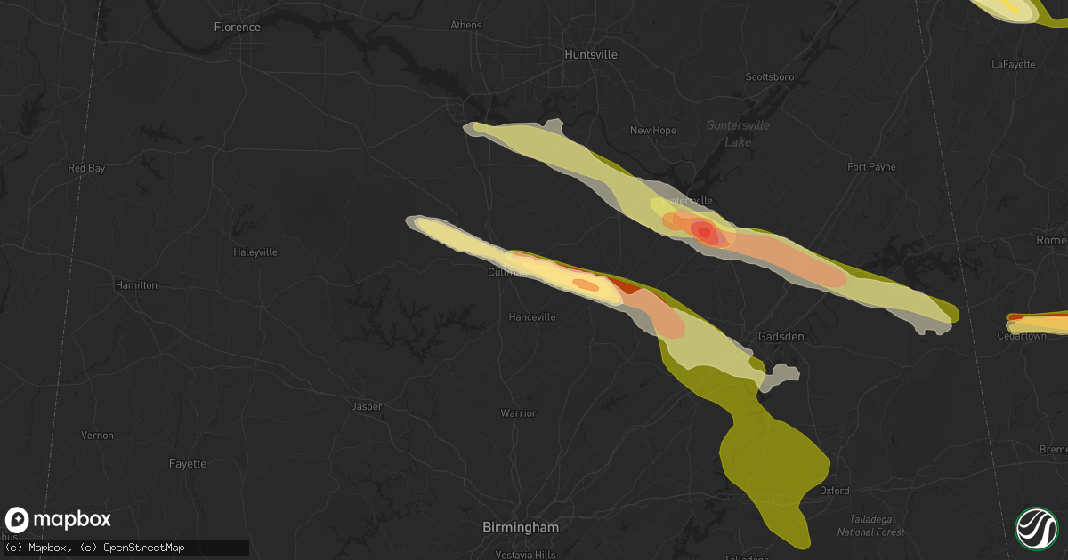
Hail Map in Cullman, AL on April 10, 2025
Get this storm
April 10 map
$229
one time, instant access
Download today. No call, no setup
Keep the $229
Bought the map and want the full workflow? Apply the entire $229 to a subscription within 7 days. None of it is wasted.
Every map, not just this one
This buys you this map. Subscription and you get every map we run, in the markets you choose from a few cities to whole states to nationwide. Plus real-time alerts the moment a storm fires.
Contact data
Name, contact info, occupancy, even credit band for addresses in the footprint. You go from where it hit to who to call.
Become the source they trust
Unlimited branding weather history reports on demand. You already have the documented answer ready for the property owner, and you are the one who showed up with it.
Property data and RoofTrace estimates
Pull up any address you have got, its value and the exact code rules for that jurisdiction, straight from One Click Code. Then RoofTrace estimates the squares, pitch, and roof value, priced the way you price.
Storm reports in Cullman, AL
Cullman, AL
| Date | Description |
|---|---|
| 04/10/20256:59 PM CDT | Tree down across road at 300 cr 1435... Ne of the city of cullman al. |
| 04/10/20256:59 PM CDT | Corrects previous tstm wnd dmg report from 2 se west point. Tree reported down blocking the roadway at 1259 cr 1184 in cullman county. |
| 04/10/20256:59 PM CDT | Tree down over road way at 424 wallace rd in cullman al. |
| 04/10/20256:59 PM CDT | Tree down blocking the roadway at 977 cr 1184 in cullman county. |
| 04/10/20256:55 PM CDT | Corrects previous tstm wnd dmg report from 1 sw holly pond. Tree reported down across the roadway at cr 795 and lick creek rd... Se of holly pond. |
| 04/10/20256:50 PM CDT | Corrects previous tstm wnd dmg report from 2 se west point. Tree reported down at 1429 cr 1184 in cullman county. |
| 04/10/20256:45 PM CDT | Tree down across roadway. Brooklyn area north of holly pond. |
| 04/10/20256:40 PM CDT | A local report indicates 1.50 inch wind near 5 E Cullman |
| 04/10/20256:35 PM CDT | Tree and power lines down over the road se of eva at 2462 cr 1492. |
| 04/09/20257:55 PM CDT | Tree reported down across the roadway at cr 795 and lick creek rd... Se of holly pond. |
| 04/09/20257:54 PM CDT | Tree reported down blocking the roadway at 1259 cr 1184 in cullman county. |
| 04/09/20257:10 PM CDT | Tree reported down at 690 cr 1541 in cullman county. |
| 04/09/20257:10 PM CDT | Tree reported down on 2290 cr 1682 near the new hope baptist church. |
| 04/09/20257:09 PM CDT | Tree reported down at 1429 cr 1184 in cullman county. |
| 04/09/20257:00 PM CDT | Golf ball size hiail. |
All States Impacted by Hail Map on April 10, 2025
All Cities Impacted by Hail Map on April 10, 2025
- Hawk Point, MO
- Warrenton, MO
- Troy, MO
- Wright City, MO
- Moscow Mills, MO
- Foristell, MO
- Wentzville, MO
- Lake Saint Louis, MO
- O'Fallon, MO
- Saint Peters, MO
- Saint Charles, MO
- Labadie, MO
- Villa Ridge, MO
- Gray Summit, MO
- Pacific, MO
- Chesterfield, MO
- Wildwood, MO
- Ballwin, MO
- Hilham, TN
- Gainesboro, TN
- Whitleyville, TN
- Dittmer, MO
- Olmstead, KY
- Cookeville, TN
- Mill Shoals, IL
- Burnt Prairie, IL
- Mount Vernon, IN
- Carmi, IL
- Grayville, IL
- Crossville, IL
- Winchester, TN
- Belvidere, TN
- Adairville, KY
- Ewing, IL
- Macedonia, IL
- Benton, IL
- Fairfield, IL
- Finley, TN
- Golden Gate, IL
- Dyersburg, TN
- Halls, TN
- Blytheville, AR
- Luxora, AR
- Dell, AR
- Russellville, KY
- Princeton, IN
- Oliver Springs, TN
- Sunbright, TN
- Deer Lodge, TN
- Uniontown, KY
- Morganfield, KY
- Decherd, TN
- Cowan, TN
- Sewanee, TN
- Wartburg, TN
- Harriman, TN
- Ripley, TN
- Friendship, TN
- Alamo, TN
- Bells, TN
- Osceola, AR
- Waverly, KY
- Gates, TN
- Sherwood, TN
- Mulberry, TN
- Patoka, IN
- Francisco, IN
- South Pittsburg, TN
- Henning, TN
- Brownsville, TN
- Spencer, TN
- Rock Island, TN
- Hanson, KY
- Manitou, KY
- Nebo, KY
- Madisonville, KY
- Sacramento, KY
- Bremen, KY
- White Plains, KY
- Earlington, KY
- Mortons Gap, KY
- Sebree, KY
- Slaughters, KY
- Utica, KY
- Calhoun, KY
- Rumsey, KY
- Owensboro, KY
- Island, KY
- Greenville, KY
- Central City, KY
- Philpot, KY
- Graham, KY
- Livermore, KY
- Centertown, KY
- Jasper, TN
- Guild, TN
- Bryant, AL
- Trenton, GA
- Spring City, TN
- Grandview, TN
- Rockwood, TN
- Gadsden, TN
- Oakdale, TN
- Oak Ridge, TN
- Ten Mile, TN
- Jackson, TN
- Humboldt, TN
- Denmark, TN
- Whiteville, TN
- Mercer, TN
- Medon, TN
- Beech Bluff, TN
- Pinson, TN
- Henderson, TN
- Toone, TN
- Dixon, KY
- Providence, KY
- Robards, KY
- Corydon, KY
- Poseyville, IN
- Evansville, IN
- Wadesville, IN
- Henderson, KY
- New Harmony, IN
- Haubstadt, IN
- Owensville, IN
- Cynthiana, IN
- Fort Branch, IN
- Reed, KY
- Spottsville, KY
- Boonville, IN
- Chandler, IN
- Newburgh, IN
- Elberfeld, IN
- Oakland City, IN
- Lynnville, IN
- Chrisney, IN
- Dale, IN
- Winslow, IN
- Tennyson, IN
- Stendal, IN
- Spurgeon, IN
- Gentryville, IN
- Huntingburg, IN
- Velpen, IN
- Richland, IN
- Rockport, IN
- Lincoln City, IN
- Grandview, IN
- Holland, IN
- Santa Claus, IN
- Maceo, KY
- Lamar, IN
- Whitesville, KY
- Hawesville, KY
- Hartford, KY
- Lewisport, KY
- Reynolds Station, KY
- Powderly, KY
- Beaver Dam, KY
- Rockport, KY
- Beech Creek, KY
- Drakesboro, KY
- Knoxville, TN
- Rossville, GA
- Flintstone, GA
- Lookout Mountain, GA
- Lookout Mountain, TN
- Chattanooga, TN
- Pikeville, TN
- Ferdinand, IN
- Evanston, IN
- Wildwood, GA
- Rising Fawn, GA
- Finger, TN
- Bethel Springs, TN
- McHenry, KY
- Dundee, KY
- Rosine, KY
- Falls Of Rough, KY
- Belton, KY
- Beechmont, KY
- Browder, KY
- Caneyville, KY
- Olaton, KY
- Cromwell, KY
- Horse Branch, KY
- Fordsville, KY
- Cloverport, KY
- Rochester, KY
- Morgantown, KY
- Dunmor, KY
- Chickamauga, GA
- Fort Oglethorpe, GA
- Bloomfield, KY
- Soddy Daisy, TN
- Graysville, TN
- Dunlap, TN
- Saint Meinrad, IN
- Bristow, IN
- Birdseye, IN
- Leopold, IN
- Troy, IN
- Tell City, IN
- Ringgold, GA
- Rock Spring, GA
- Rockford, TN
- Louisville, TN
- Lenoir City, TN
- Bridgeport, AL
- Attalla, AL
- Steele, AL
- Gadsden, AL
- Tunnel Hill, GA
- Rocky Face, GA
- Seymour, TN
- Farragut, TN
- Etowah, TN
- Springfield, KY
- Bardstown, KY
- Willisburg, KY
- Piedmont, AL
- Iuka, IL
- Sevierville, TN
- Walland, TN
- Decatur, AL
- Savannah, TN
- Lutts, TN
- Maryville, TN
- Friendsville, TN
- Tanner, AL
- Pigeon Forge, TN
- Somerville, AL
- Gatlinburg, TN
- Moulton, AL
- Courtland, AL
- Hillsboro, AL
- Town Creek, AL
- Marshall, NC
- Guntersville, AL
- Madison, AL
- Russellville, AL
- Ellijay, GA
- Hartselle, AL
- Trinity, AL
- Union Grove, AL
- Laceys Spring, AL
- Valhermoso Springs, AL
- Albertville, AL
- Estillfork, AL
- Talking Rock, GA
- Boaz, AL
- Como, MS
- Jasper, GA
- Crossville, AL
- Arab, AL
- Dawsonville, GA
- Cedartown, GA
- Aragon, GA
- Rockmart, GA
- Mcminnville, TN
- Vinemont, AL
- Danville, AL
- Addison, AL
- Otto, NC
- Marble Hill, GA
- Mount Hope, AL
- Woodbury, TN
- Ball Ground, GA
- Lula, GA
- Pekin, IN
- Salem, IN
- Gainesville, GA
- Tate, GA
- Collinsville, AL
- Cave Spring, GA
- Dallas, GA
- Taylorsville, GA
- Cartersville, GA
- Scottsboro, AL
- Henryville, IN
- Underwood, IN
- Scaly Mountain, NC
- Falkville, AL
- Highlands, NC
- Franklin, NC
- Valley Head, AL
- Leesburg, AL
- Cullman, AL
- Centre, AL
- Eastanollee, GA
- Toccoa, GA
- Fair Play, SC
- Westminster, SC
- Lavonia, GA
- Martin, GA
- Holly Pond, AL
- Otisco, IN
- Eva, AL
- Baileyton, AL
- Sweetwater, TN
- Philadelphia, TN
- Maysville, GA
- Commerce, GA
- Cumming, GA
- Memphis, IN
- London, KY
- Byhalia, MS
- Hartwell, GA
- Marysville, IN
- Lily, KY
- Corbin, KY
- Acworth, GA
- Woodstock, GA
- Emerson, GA
- Oakwood, GA
- Dana, KY
- Blountsville, AL
- Cornelia, GA
- Alpharetta, GA
- Horton, AL
- Altoona, AL
- Henagar, AL
- Pisgah, AL
- Sylvania, AL
- Fort Payne, AL
- Mentone, AL
- Roswell, GA
- Portland, TN
- Ivel, KY
- Betsy Layne, KY
- Harold, KY
- Banner, KY
- Cross Plains, TN
- Orlinda, TN
- Dacula, GA
- Tomahawk, KY
- Boons Camp, KY
- Paintsville, KY
- Cottontown, TN
- Talmo, GA
- Pendergrass, GA
- Kennesaw, GA
- Hoschton, GA
- Marietta, GA
- Springfield, TN
- Braselton, GA
- Jefferson, GA
- Starr, SC
- Anderson, SC
- Oneonta, AL
- Gallant, AL
- Auburn, GA
- Buford, GA
- Ashville, AL
- Buchanan, GA
- Wilsondale, WV
- Kermit, WV
- Williamsburg, KY
- Suwanee, GA
- Rainbow City, AL
- Ragland, AL
- Ohatchee, AL
- Bremen, GA
- Debord, KY
- Crum, WV
- Temple, GA
- Lincoln, AL
- Anniston, AL
- Alexandria, AL
- Ripley, WV
- Villa Rica, GA
- Warfield, KY
- Winston, GA
- Douglasville, GA
- Palmetto, GA
- Fairburn, GA
- Talladega, AL
- Munford, AL
- Oxford, AL
- Eastaboga, AL
- Sharpsburg, GA
- Union City, GA
- Roopville, GA
- Newnan, GA
- Woodland, AL
- Graham, AL
- Delta, AL
- Carrollton, GA
- Heflin, AL
- Whitesburg, GA
- Tyrone, GA
- Bowdon, GA
- Fayetteville, GA
- Bragg City, MO
- Hayti, MO
- Caruthersville, MO
- Kennett, MO
- Hanceville, AL
- Cedarbluff, MS
- Starkville, MS
- West Point, MS
- Columbus, MS
- Lineville, AL
- Senoia, GA
- Peachtree City, GA
- Brooks, GA
- Hampton, GA
- Wedowee, AL
- Eupora, MS
- Griffin, GA
- Cragford, AL
- Clinton, TN
- Williamson, GA
- Milner, GA
- Barnesville, GA
- Jackson, GA
- Wadley, AL
- Roanoke, AL
- Flat Rock, AL
- Maben, MS
- Sturgis, MS
- Zebulon, GA
- Forsyth, GA
- Ethelsville, AL
- Carrollton, AL
- Crawford, MS
- Brooksville, MS
- Decatur, TN
- Dayton, TN
- Lafayette, AL
- Five Points, AL
- Carrollton, MS
- Holcomb, MS
- Itta Bena, MS
- Louisville, MS
- Macon, GA
- Juliette, GA
- Macon, MS
- Winona, MS
- Kilmichael, MS
- Alcoa, TN
- McCarley, MS
- Aliceville, AL
- Gordo, AL
- Weir, MS
- Ackerman, MS
- French Camp, MS
- Lake Village, AR
- McCool, MS
- Ethel, MS
- Moundville, AL
- Marion, AL
- Centreville, AL
- Stewart, MS
- Jeffersonville, GA
- Dry Branch, GA
- Akron, AL
- Greensboro, AL
- Cleveland, GA
- Dahlonega, GA
- Noxapater, MS
- Danville, GA
- Yazoo City, MS
- Vaughan, MS
- Canton, MS
- Brandon, MS
- Lena, MS
- Huntsville, AL
- New Market, AL
- Hazel Green, AL
- Madison, MS
- Flowery Branch, GA
- Flowood, MS
- Pelahatchie, MS
- Morton, MS
- Ider, AL
- Hayesville, NC
- Dillard, GA
- Clayton, GA
- New Salisbury, IN
- Ramsey, IN
- Marengo, IN
- Milltown, IN
- Depauw, IN
- Owens Cross Roads, AL
- New Hope, AL
- Gurley, AL
- Mountain Rest, SC
- Sale Creek, TN


