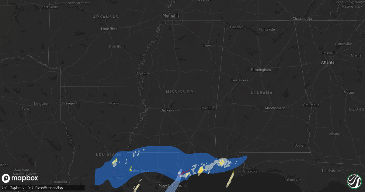
Hail Map in Mississippi on April 10, 2024
Get this storm
April 10 map
$229
one time, instant access
Download today. No call, no setup
Keep the $229
Bought the map and want the full workflow? Apply the entire $229 to a subscription within 7 days. None of it is wasted.
Every map, not just this one
This buys you this map. Subscription and you get every map we run, in the markets you choose from a few cities to whole states to nationwide. Plus real-time alerts the moment a storm fires.
Contact data
Name, contact info, occupancy, even credit band for addresses in the footprint. You go from where it hit to who to call.
Become the source they trust
Unlimited branding weather history reports on demand. You already have the documented answer ready for the property owner, and you are the one who showed up with it.
Property data and RoofTrace estimates
Pull up any address you have got, its value and the exact code rules for that jurisdiction, straight from One Click Code. Then RoofTrace estimates the squares, pitch, and roof value, priced the way you price.
Storm reports in Mississippi
Mississippi
| Date | Description |
|---|---|
| 04/10/20241:00 PM CDT | Flash flooding occurred near the intersection of stout rd and lakeshire cir. Flooding had subsided from peak but was still occurring at 430 pm. |
| 04/10/202411:43 AM CDT | George county ema reports trees down on barton-agricola rd and marshall smith rd... On agricola-latonia rd... River road near ellis hodge rd... And on hwy 26 near pasca |
| 04/10/202411:16 AM CDT | Report from mping: quarter |
| 04/10/202411:16 AM CDT | Report from mping: 1-inch tree limbs broken; shingles blown off. |
| 04/10/202411:06 AM CDT | Report from mping: 1-inch tree limbs broken; shingles blown off. |
| 04/10/202411:04 AM CDT | Report of multiple power lines downed in shady grove community. |
| 04/10/202411:02 AM CDT | Mesonet statio |
| 04/10/202411:02 AM CDT | Mesonet station xbil biloxi. |
| 04/10/202410:53 AM CDT | Asos station kgpt gulfport-biloxi intl airport. |
| 04/10/202410:52 AM CDT | Report from mping: trees uprooted or snapped; roof blown off. |
| 04/10/202410:51 AM CDT | Tree on house on timberwood ln in picayune. |
| 04/10/202410:50 AM CDT | Half dollar size hail reported in biloxi. |
| 04/10/202410:50 AM CDT | Picture of estimated golf ball sized hail in woolmarket. |
| 04/10/202410:48 AM CDT | Report from mping: half dollar |
| 04/10/202410:40 AM CDT | Damage reported at the rouses in diamondhead. |
| 04/10/202410:40 AM CDT | Trees down on elmer ladner rd. |
| 04/10/202410:39 AM CDT | Report from mping: quarter |
| 04/10/202410:39 AM CDT | Trees down on edwin ladner rd. |
| 04/10/202410:33 AM CDT | Gpt asos measured 52 kts. |
| 04/10/202410:32 AM CDT | Report from mping: 1-inch tree limbs broken; shingles blown off. |
| 04/10/202410:32 AM CDT | Report from mping: quarter |
| 04/10/202410:30 AM CDT | Nws storm survey confirms damage in harrison county... Ms consistent with an ef-1 tornado. The tornado touched down on cleveland ladner rd and river rd... Where it tore |
| 04/10/202410:27 AM CDT | Tree down across old hwy 11. |
| 04/10/202410:20 AM CDT | Nws storm survey assessed the damage in hancock county at stennis space center and near kiln... Ms. There is evidence of strong wind damage... Which is possibly tornadi |
| 04/10/202410:19 AM CDT | Numerous vehicles damaged at stennis by thrown container. |
| 04/10/202410:15 AM CDT | A co |
| 04/10/202410:15 AM CDT | A couple of trees down in the county. |
| 04/10/202410:14 AM CDT | Tree down across old salt rd. |
| 04/10/202410:07 AM CDT | Tree down on wille buckley road. |
| 04/10/202410:07 AM CDT | Tree down on washington trail. |
| 04/10/202410:03 AM CDT | Debris blocking hwy 11 in picayune. |
| 04/10/20249:55 AM CDT | Trees down on mapp turner road. |
| 04/10/20249:54 AM CDT | Trees down on progress road. |
| 04/10/20249:54 AM CDT | Tree down on highway 42. |
| 04/10/20249:50 AM CDT | Trees down on dan walker road. |
| 04/10/20249:48 AM CDT | Tree fell on car along ten mile creek road. |
| 04/10/20249:36 AM CDT | Tree down on nursing home. No injuries. |
| 04/10/20249:36 AM CDT | Numerous trees and powerlines down across monticello. |
| 04/10/20249:35 AM CDT | Trees down on several homes along mary street. |
| 04/10/20249:32 AM CDT | Tree down on a home. |
| 04/10/20249:25 AM CDT | Multiple trees down in the county with several roads blocked. Roads are being cleared now. |
| 04/10/20249:20 AM CDT | Power lines down near bogue chitto and a couple trees down in se part of the county. |
| 04/10/20248:40 AM CDT | Tree limbs down causing power outages in centreville. Relayed via social media. |
All States Impacted by Hail Map on April 10, 2024
Cities Impacted by Hail Map on April 10, 2024
- Kinder, LA
- Elton, LA
- Welsh, LA
- Jennings, LA
- Roanoke, LA
- Lake Arthur, LA
- Maringouin, LA
- Rosedale, LA
- Gueydan, LA
- Iota, LA
- Basile, LA
- Lottie, LA
- Livonia, LA
- Oscar, LA
- Mermentau, LA
- Morse, LA
- Evangeline, LA
- Eunice, LA
- Egan, LA
- Opelousas, LA
- Washington, LA
- Bunkie, LA
- Morrow, LA
- Estherwood, LA
- Crowley, LA
- Mamou, LA
- Branch, LA
- Rayne, LA
- Church Point, LA
- Ville Platte, LA
- Scott, LA
- Duson, LA
- Sunset, LA
- Carencro, LA
- Lafayette, LA
- Kaplan, LA
- Maurice, LA
- Abbeville, LA
- Port Barre, LA
- Cottonport, LA
- Simmesport, LA
- Palmetto, LA
- Evergreen, LA
- Plaucheville, LA
- Moreauville, LA
- Breaux Bridge, LA
- Fordoche, LA
- Youngsville, LA
- Batchelor, LA
- Morganza, LA
- Krotz Springs, LA
- Arnaudville, LA
- Lettsworth, LA
- Melville, LA
- Broussard, LA
- New Iberia, LA
- Saint Martinville, LA
- Erath, LA
- Grosse Tete, LA
- Delcambre, LA
- Loreauville, LA
- Saint Francisville, LA
- Woodville, MS
- Angola, LA
- Monterey, LA
- New Roads, LA
- Jarreau, LA
- Ventress, LA
- Port Allen, LA
- Erwinville, LA
- Glynn, LA
- Lakeland, LA
- Rougon, LA
- Jackson, LA
- Brusly, LA
- Plaquemine, LA
- Baton Rouge, LA
- Addis, LA
- Baker, LA
- Slaughter, LA
- Centreville, MS
- Norwood, LA
- Zachary, LA
- Ethel, LA
- Pride, LA
- Wilson, LA
- Liberty, MS
- Gloster, MS
- Clinton, LA
- Greenwell Springs, LA
- Denham Springs, LA
- Bay Saint Louis, MS
- Walker, LA
- Greensburg, LA
- Holden, LA
- Amite, LA
- Pine Grove, LA
- Kentwood, LA
- Osyka, MS
- Livingston, LA
- Magnolia, MS
- Independence, LA
- Springfield, LA
- Albany, LA
- Hammond, LA
- Roseland, LA
- Tickfaw, LA
- Fluker, LA
- Summit, MS
- Mccomb, MS
- Smithdale, MS
- Loranger, LA
- Ponchatoula, LA
- Folsom, LA
- Mount Hermon, LA
- Franklinton, LA
- Robert, LA
- Husser, LA
- Tylertown, MS
- New Orleans, LA
- Slidell, LA
- Saint Bernard, LA
- Meraux, LA
- Chalmette, LA
- Violet, LA
- Braithwaite, LA
- Lafitte, LA
- Arabi, LA
- Harvey, LA
- Ama, LA
- Marrero, LA
- Belle Chasse, LA
- Westwego, LA
- Gretna, LA
- Cut Off, LA
- Barataria, LA
- Madisonville, LA
- Covington, LA
- Columbia, MS
- Kokomo, MS
- Foxworth, MS
- Jayess, MS
- Monticello, MS
- Ruth, MS
- Sandy Hook, MS
- Angie, LA
- Bush, LA
- Bogalusa, LA
- Mandeville, LA
- Pearl River, LA
- Lacombe, LA
- Abita Springs, LA
- Poplarville, MS
- Picayune, MS
- Carriere, MS
- Gautier, MS
- Lumberton, MS
- Stennis Space Center, MS
- Pearlington, MS
- Ocean Springs, MS
- Kiln, MS
- Perkinston, MS
- Diamondhead, MS
- Pass Christian, MS
- Waveland, MS
- Saucier, MS
- McHenry, MS
- Gulfport, MS
- Long Beach, MS
- Biloxi, MS
- Wiggins, MS
- Brooklyn, MS
- Diberville, MS
- Vancleave, MS
- McLain, MS
- Lucedale, MS
- Pascagoula, MS
- Moss Point, MS
- Gulf Shores, AL
- Grand Bay, AL
- Mobile, AL
- Wilmer, AL
- Franklin, LA
- Jeanerette, LA
- Morgan City, LA
- Semmes, AL
- Theodore, AL
- Irvington, AL
- Eight Mile, AL
- Pierre Part, LA
- Coden, AL
- Bayou La Batre, AL
- Saraland, AL
- Foley, AL
- White Castle, LA
- Magnolia Springs, AL
- Fairhope, AL
- Daphne, AL
- Bay Minette, AL
- Stapleton, AL
- Silverhill, AL
- Loxley, AL
- Robertsdale, AL
- McDavid, FL
- Molino, FL
- Century, FL
- Panama City Beach, FL
- Inlet Beach, FL
- Chunchula, AL
- Pensacola, FL


