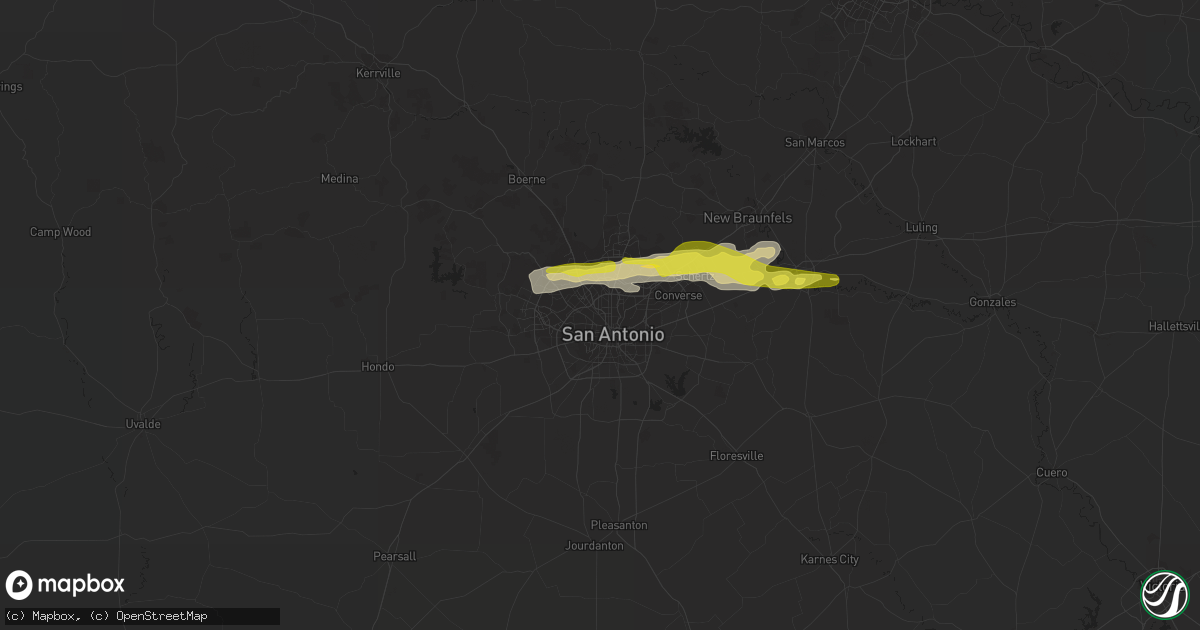
Hail Map in San Antonio, TX on April 10, 2022
Get this storm
April 10 map
$229
one time, instant access
Download today. No call, no setup
Keep the $229
Bought the map and want the full workflow? Apply the entire $229 to a subscription within 7 days. None of it is wasted.
Every map, not just this one
This buys you this map. Subscription and you get every map we run, in the markets you choose from a few cities to whole states to nationwide. Plus real-time alerts the moment a storm fires.
Contact data
Name, contact info, occupancy, even credit band for addresses in the footprint. You go from where it hit to who to call.
Become the source they trust
Unlimited branding weather history reports on demand. You already have the documented answer ready for the property owner, and you are the one who showed up with it.
Property data and RoofTrace estimates
Pull up any address you have got, its value and the exact code rules for that jurisdiction, straight from One Click Code. Then RoofTrace estimates the squares, pitch, and roof value, priced the way you price.
Storm reports in San Antonio, TX
San Antonio, TX
| Date | Description |
|---|---|
| 04/09/202211:15 PM CDT | A local report indicates 1.00 inch wind near 3 WNW LIVE OAK |
| 04/09/202211:08 PM CDT | Public report relayed via social media of quarter size hail at the intersection of de zavala road and interstate 10. |
All Cities Impacted by Hail Map on April 10, 2022
- Cleveland, OK
- Prue, OK
- Pawnee, OK
- Barnsdall, OK
- Hominy, OK
- Pawhuska, OK
- Morrison, OK
- Wynona, OK
- Fairfax, OK
- Ralston, OK
- Osage, OK
- Skiatook, OK
- Stockton, MO
- Tilden, TX
- Ash Grove, MO
- Everton, MO
- Willard, MO
- Brighton, MO
- Hillsboro, MO
- Fletcher, MO
- Blackwell, MO
- De Soto, MO
- Potosi, MO
- Richwoods, MO
- Sullivan, MO
- Bolivar, MO
- Buffalo, MO
- Half Way, MO
- Morrisville, MO
- Oronogo, MO
- Jasper, MO
- Asbury, MO
- Garber, OK
- Enid, OK
- Kremlin, OK
- Bastrop, TX
- San Marcos, TX
- Seguin, TX
- Marion, TX
- Fowlerton, TX
- Cotulla, TX
- Cibolo, TX
- Schertz, TX
- San Antonio, TX
- Hunter, OK
- Steelville, MO
- New Braunfels, TX
- McQueeney, TX
- Universal City, TX
- Helotes, TX
- Alma, MI
- Saint Louis, MI
- Delaware, OK
- Bois D Arc, MO
- Pleasant Hope, MO
- Elkland, MO
- Walnut Grove, MO
- Nowata, OK
- Bartlesville, OK
- Lenapah, OK
- Bourbon, MO
- Wheatland, MO
- Pittsburg, MO
- Weaubleau, MO
- Flemington, MO
- Humansville, MO
- Urbana, MO
- Polk, MO
- Louisburg, MO
- Hermitage, MO
- Sparta, IL
- Evansville, IL
- Baldwin, IL
- Pipe Creek, TX
- Festus, MO
- Fair Play, MO
- Ponca City, OK
- Rolla, MO
- Newburg, MO
- Osage Beach, MO
- Sunrise Beach, MO
- Jerico Springs, MO
- Lockwood, MO
- Arcola, MO
- Fairmont, OK
- Carthage, MO
- Diamond, MO
- Sarcoxie, MO
- Reeds, MO
- Webb City, MO
- Miller, MO
- Duenweg, MO
- Riverton, KS
- La Russell, MO
- Avilla, MO
- Golden City, MO
- Baxter Springs, KS
- Joplin, MO
- Columbus, KS
- Carterville, MO
- Galena, KS
- Long Lane, MO
- Lebanon, MO
- Windyville, MO
- Wheeler, MI
- Breckenridge, MI
- Sumner, MI
- Riverdale, MI
- Elwell, MI
- Greenfield, MO
- Frankford, MO
- Chetopa, KS
- Ramona, OK
- Pinckneyville, IL
- Collins, MO
- Prairie Du Rocher, IL
- Chelsea, MI
- Grass Lake, MI
- Cook Sta, MO
- Saint James, MO
- Perry, OK
- Fults, IL
- Red Bud, IL
- Tamaroa, IL
- Cadet, MO
- Dittmer, MO
- Holts Summit, MO
- Ochelata, OK
- Coulterville, IL
- Valmeyer, IL
- Cedar Creek, TX
- Nash, OK
- Carrier, OK
- Pond Creek, OK
- Dunnegan, MO
- Marissa, IL
- Modoc, IL
- Westphalia, MO
- Saint Thomas, MO
- Jefferson City, MO
- Weir, KS
- Pittsburg, KS
- Shidler, OK
- Converse, IN
- Amboy, IN
- Waynesville, MO
- Fort Leonard Wood, MO
- Cherryville, MO
- Davisville, MO
- Hermann, MO
- South Greenfield, MO
- Carl Junction, MO
- Welch, OK
- Jackson, MI
- Clarklake, MI
- Brooklyn, MI
- Burbank, OK
- Blanco, TX
- Edgar Springs, MO
- Claremore, OK
- Laredo, TX
- Charlotte, TX
- Jourdanton, TX
- Bandera, TX
- Mico, TX
- Springfield, MO
- Conway, MO
- Niangua, MO
- Grovespring, MO
- Herculaneum, MO
- Crystal City, MO


